Showing 2773 items
matching no. 35
-
 Warrnambool and District Historical Society Inc.
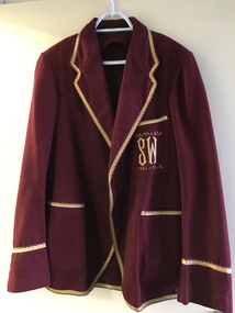
Clothing - Blazer, Blazer South Warrnambool cricket Club, 1930s
This blazer belonged to Gordon Burleigh (1888-1956) who lived at ‘Macken Hill’ in Mepunga. He was the ninth child of James and Janet Burleigh who were early settlers in the Nullawarre area. Gordon Burleigh was a prominent and successful sportsman playing football and cricket in the local area and playing one game in 1914 in the Victorian Football League for Geelong. The blazer indicates that the cricket team he played for was the Premier team for 1934, 1935, and 1936 and the ‘S.W.’ on the blazer pocket may indicate South Warrnambool but it is more likely to be ‘South West’, perhaps the name of the district the team played in. This blazer is of considerable interest as it belonged to Gordon Burleigh, a prominent sportsman in the district in the early decades of the 20th century.This is a maroon-coloured blazer which belonged to Gordon Burleigh of Mepunga. It has gold-coloured edging and piping on the sleeves, pockets and edges (collar etc) of the blazer. It has two material-covered buttons and stitched buttonholes and gold stitching on the pocket. There is a tag on the collar but no writing is visible. Pocket: ‘Premiers, S.W., 1934-35-36’gordon burleigh, local cricket in the 1930s, warrnambool, cricket blazer -
 Greensborough Historical Society
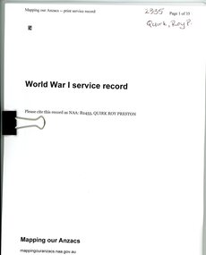
Document, World War I Service Record: Roy Preston Quirk, 1914-1923
This collection of information on Roy Preston Quirk was used in the GHS World War I Project to compile a biography of Quirk.35 p. war service record and 3p. news clippings.roy preston quirk, world war 1 project -
 Federation University Historical Collection
Book, Toni Woolley et al, Port Fairy Community and Organisational Plan, 1999
Port Fairy Community and Organisational Plan. University of Ballarat Students' Project.White bound book of 35 pages plus 6 appendices.port fairy, toni woolley, tamara lang, janelle gilbert, ben balshaw, grant caromody, executive summary, introduction, background to port fairy, methodology, limitations, appraisal of tourism planning and development to date, assessment of local community issues, attitudes and involvement in tourism, roles of local and regional tourism associations, effectiveness of local & regional tourism associations, analysis of services and service quality, moyne shire council, friends of port fairy, tourism victoria, country victoria tourism, great ocean road marketing, shipwreck coast tourism, port fairy tourism association inc, moyne shire, department of natural resources and environment, the western coastal board, tourism accreditation board of victoria, george borg, craig delahoy, michael hearn, jodie honan, judith kershaw, andrea lowenthal, neil martin, john ploenges, james purcell, peter strickland, mark thompson, libby wilson, michael pearlman, battle of the moyne, tourism planning, great ocean road -
 Bendigo Historical Society Inc.
Book - CHINESE AND THE LAW, THE GOLDEN DRAGON MUSEUM, 2001
Chinese and The Law, the Golden Dragon Museum 35 page bookletBrian Barrow.victoria, history, chinese, gold mines and mining, chinese - history - australia. -
 Ruyton Girls' School
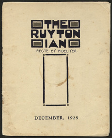
Magazine, Ruyton Girls' School, The Ruytonian, 1928
In July 1909, a modest 12-page booklet was put together by members of the fledgling Old Ruytonians Association (ORA) and distributed to the Ruyton Girls' School community. It was one of their first projects, and their aim was to nurture continuing interest in the School among former and current students. They named it "The Ruytonian." At first, The Ruytonian was produced twice yearly, and always bore a plain cover with a simple name banner. Initially, it was the work of volunteer editors from the ORA, but in 1913 they handed the publication over to the first student editors, Esther Gibson and Lucy Tickell. Since that time, the style and content of The Ruytonian has continuously evolved. The biggest shifts occurred in 1942 when it transitioned to a yearly publication, and in 1969 when it moved to a larger A4 format with a cover image specifically selected for that year.The record has strong historic significance as it pertains to the fourth oldest girls' school in Victoria, Australia. Ruyton was founded in 1878 in the Bulleen Road, Kew, home of newly widowed Mrs Charlotte Anderson (now High Street South). Due to the age of the record dating back to 1928, we can infer it is one of the few remaining complete, intact and original examples of The Ruytonian from this period. Therefore, it can be considered an outstanding representation of its type, and is a reference example for research in early Victorian school history. The record's significance is further enhanced by its exceptionally well-documented provenance, having remained the property of Ruyton Girls' School since its production.Colour publication printed on papyrus coloured paper. 35 pages.Front Cover: THE / RUYTON / IAN / RECTE ET FIDELITER. / DECEMBER, 1928 /ruyton girls' school, the ruytonian, kew, old ruytonians association, yearbook, school, publication, girls school, junior school, senior school, journal, students, teacher -
 Ruyton Girls' School
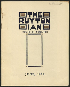
Magazine, Ruyton Girls' School, The Ruytonian, 1929
In July 1909, a modest 12-page booklet was put together by members of the fledgling Old Ruytonians Association (ORA) and distributed to the Ruyton Girls' School community. It was one of their first projects, and their aim was to nurture continuing interest in the School among former and current students. They named it "The Ruytonian." At first, The Ruytonian was produced twice yearly, and always bore a plain cover with a simple name banner. Initially, it was the work of volunteer editors from the ORA, but in 1913 they handed the publication over to the first student editors, Esther Gibson and Lucy Tickell. Since that time, the style and content of The Ruytonian has continuously evolved. The biggest shifts occurred in 1942 when it transitioned to a yearly publication, and in 1969 when it moved to a larger A4 format with a cover image specifically selected for that year.The record has strong historic significance as it pertains to the fourth oldest girls' school in Victoria, Australia. Ruyton was founded in 1878 in the Bulleen Road, Kew, home of newly widowed Mrs Charlotte Anderson (now High Street South). Due to the age of the record dating back to 1929, we can infer it is one of the few remaining complete, intact and original examples of The Ruytonian from this period. Therefore, it can be considered an outstanding representation of its type, and is a reference example for research in early Victorian school history. The record's significance is further enhanced by its exceptionally well-documented provenance, having remained the property of Ruyton Girls' School since its production.Colour publication printed on papyrus coloured paper. 35 pages.Front Cover: M. Wenmoth. / THE / RUYTON / IAN / RECTE ET FIDELITER. / JUNE, 1929 /ruyton girls' school, the ruytonian, kew, old ruytonians association, yearbook, school, publication, girls school, junior school, senior school, journal, students, teacher -
 Ruyton Girls' School
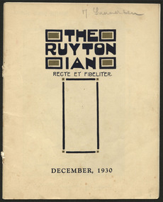
Magazine, Ruyton Girls' School, The Ruytonian, 1930
In July 1909, a modest 12-page booklet was put together by members of the fledgling Old Ruytonians Association (ORA) and distributed to the Ruyton Girls' School community. It was one of their first projects, and their aim was to nurture continuing interest in the School among former and current students. They named it "The Ruytonian." At first, The Ruytonian was produced twice yearly, and always bore a plain cover with a simple name banner. Initially, it was the work of volunteer editors from the ORA, but in 1913 they handed the publication over to the first student editors, Esther Gibson and Lucy Tickell. Since that time, the style and content of The Ruytonian has continuously evolved. The biggest shifts occurred in 1942 when it transitioned to a yearly publication, and in 1969 when it moved to a larger A4 format with a cover image specifically selected for that year.The record has strong historic significance as it pertains to the fourth oldest girls' school in Victoria, Australia. Ruyton was founded in 1878 in the Bulleen Road, Kew, home of newly widowed Mrs Charlotte Anderson (now High Street South). Due to the age of the record dating back to 1930, we can infer it is one of the few remaining complete, intact and original examples of The Ruytonian from this period. Therefore, it can be considered an outstanding representation of its type, and is a reference example for research in early Victorian school history. The record's significance is further enhanced by its exceptionally well-documented provenance, having remained the property of Ruyton Girls' School since its production.Colour publication printed on papyrus coloured paper. 35 pages.Front Cover: J. Gunnersen / THE / RUYTON / IAN / RECTE ET FIDELITER. / DECEMBER, 1930 /ruyton girls' school, the ruytonian, kew, old ruytonians association, yearbook, school, publication, girls school, junior school, senior school, journal, students, teacher -
 Ruyton Girls' School
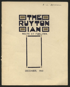
Magazine, Ruyton Girls' School, The Ruytonian, 1942
In July 1909, a modest 12-page booklet was put together by members of the fledgling Old Ruytonians Association (ORA) and distributed to the Ruyton Girls' School community. It was one of their first projects, and their aim was to nurture continuing interest in the School among former and current students. They named it "The Ruytonian." At first, The Ruytonian was produced twice yearly, and always bore a plain cover with a simple name banner. Initially, it was the work of volunteer editors from the ORA, but in 1913 they handed the publication over to the first student editors, Esther Gibson and Lucy Tickell. Since that time, the style and content of The Ruytonian has continuously evolved. The biggest shifts occurred in 1942 when it transitioned to a yearly publication, and in 1969 when it moved to a larger A4 format with a cover image specifically selected for that year.The record has strong historic significance as it pertains to the fourth oldest girls' school in Victoria, Australia. Ruyton was founded in 1878 in the Bulleen Road, Kew, home of newly widowed Mrs Charlotte Anderson (now High Street South). Due to the age of the record dating back to 1942, we can infer it is one of the few remaining complete, intact and original examples of The Ruytonian from this period. Therefore, it can be considered an outstanding representation of its type, and is a reference example for research in early Victorian school history. The record's significance is further enhanced by its exceptionally well-documented provenance, having remained the property of Ruyton Girls' School since its production.Colour publication printed on papyrus coloured paper. 35 pages.Front Cover: D. L. Derham / THE / RUYTON / IAN / RECTE ET FIDELITER. / DECEMBER, 1942 /ruyton girls' school, the ruytonian, kew, old ruytonians association, yearbook, school, publication, girls school, junior school, senior school, journal, students, teacher -
 National Wool Museum
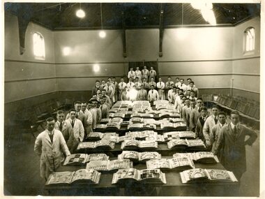
Photograph
Depicts students of the Gordon Technical College wool classing course displaying their sample books, c.1920. This photo is possibly an old copy print of a photo which hangs at the Gordon.Gordon Technical College woolclassing students, c.1920-35.woolclassing, gordon technical college - woolclassing department -
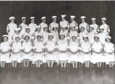 Northern District School of Nursing. Managed by Bendigo Historical Society Inc.
Photograph - Preliminary Training School 35
The Northern District School of Nursing opened in 1950 in to address the issues around nurse recruitment, training and education that had previously been hospital based. The residential school was to provide theoretical and in-house education and practical training over three years. The students would also receive practical hands-on training in the wards of associated hospitals. The Northern District School of Nursing operated from Lister House, Rowan Street, Bendigo. It was the first independent school of nursing in Victoria and continued until it closed in 1989.Preliminary training School black and white photo - School 35 - 30 students - 7th August 1957Photo of Preliminary Training School 35, 7th August 1957 -
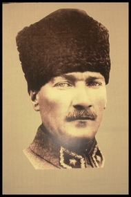 Camberwell RSL Sub-Branch
Photo, Mustafa Kemal Ataturk, 1st President of Turkey 1923 - 1938
Photo taken in 1916 when he was 35 years old. -
Federation University Historical Collection
Booklet - Walking Guide, Ballarat Heritage Walking Guide, c2015
35 page booklet with a detail from the Mining Exchange on the front. ballarat, walking trail, statues, gold monument, sturt street, unicorn hotel, ballarat town hall, sugg light, ballarat post office, camp street, summerscales building, state offices, police court, huyghue house, pratt's building, ymca, ballarat trades hall, ana hall, maps, lydiard street, ballarat gaol, ballarat school of mines, wesleyan church, ansonia, lynn's chambers, craig's royal hotel, her majesty's theatre, union bank building, bank of australasia, national bank, colonial bank of australasia, bank of new south wales, george hotel, old colonists' hall, art gallery of ballarat, union fidelity hall, goller's warehouse, dunn's warehouse, ludbrook house, reid's coffe police, ballarat railway station, cenotaph, queen victoria fountain, boer war memorial, burke and wills founitain, titanic memorial bandstand -
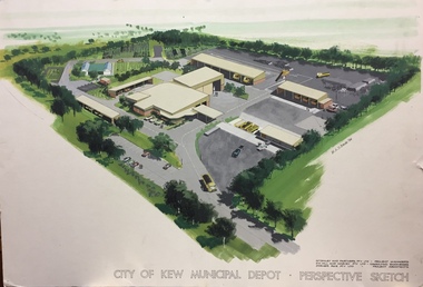 Kew Historical Society Inc
Plan, Dorner Rice Pty Ltd, City of Kew Municipal Depot, 1984
There have been a number of municipal depots in the former City of Kew (now part of the City of Boroondara). This perspective sketch by Dorner Rice Pty Ltd represents the original design of the depot at 31-35 Hutchinson Drive, on the grounds of the former Kew Mental Hospital. The large perspective drawing by W.A.D. Brodie in 1984 is an important record of the depot as originally designed.This architectural sketch is a key piece of evidence about public infrastructure developed in the former City of Kew. The facility has been modified from the original design.Large colour perspective drawing of the new Kew Municipal Depot at 31-35 Hutchinson Street, Kew. The drawing was completed by W.A.D. Brodie in 1984 on behalf of the project consortium. In addition to the projected layout of the depot, the drawing includes details of the consortium drawn together to bid for the project: project managers - McGinley & Partners; consulting engineers - D. G. Hill & Harvey Pty Ltd; and project architects - Dorner Rice Pty Ltd.Architectural Perspective Sketch : City of Kew Municipal Depot: Perspective sketch : W.A.D. Brodie 1984 : McGinley & Partners Pty Ltd Project Managers : D.G. Hill & Harvey Pty Ltd Project Engineers : Dorner Rice Pty Ltd Project Architectscity of kew (vic) - municipal depot, w.a.d. brodie, mcginley & partners pty ltd, d. g. hill & harvey pty ltd, dorner rice pty ltd -
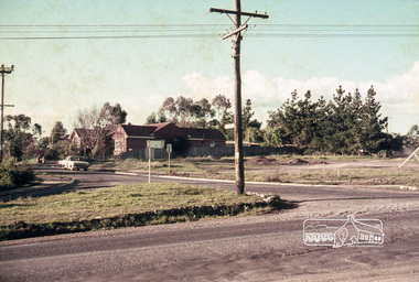 Eltham District Historical Society Inc
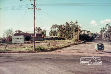
Slide, Site for the new Apex-Diamond Valley Ambulance Station, corner of Main Road and Looker Road, Montmorency, July 1969, 1969
Looking northwest from Main Road towards Looker Road at the new site for the Apex-Diamond Valley Ambulance Station before construction of Apex Way, July 1969. The Eltham Apex Club conducted a Community Service Project (1965-1968) to raise funds for a new Ambulance Station to service the community. A site bounded by the intersection of Main Road, Grand Boulevard and Looker Road at Montmorency was purchased in 1969. In 1970, Eltham Shire Council undertook roadworks to construct Apex Way in preparation for the new station as well as duplicate Main Road, Lower Plenty, east of Grand Boulevard including the new Lower Plenty Bridge, which had been opened in November 1966, bordering with the City of Heidelberg.35 mm colour positive transparency Mount - Agfacolor Service (Blue)1969-07, ambulance station, apex way, apex-diamond valley ambulance station, eltham ambulance station, looker road, lower plenty, main road, montmorency, eltham apex club -
 Eltham District Historical Society Inc
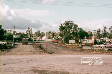
Slide, Site for the new Apex-Diamond Valley Ambulance Station, corner of Main Road and Grand Boulevard, Montmorency, July 1969, 1969
View looking west along Grand Boulevard from the intersection with Main Road and Panorama Avenue, Montmorency showing the site for the new Apex-Diamond Valley Ambulance Station and before construction of Apex Way, July 1969. The Eltham Apex Club conducted a Community Service Project (1965-1968) to raise funds for a new Ambulance Station to service the community. A site bounded by the intersection of Main Road, Grand Boulevard and Looker Road at Montmorency was purchased in 1969. In 1970, Eltham Shire Council undertook roadworks to construct Apex Way in preparation for the new station as well as duplicate Main Road, Lower Plenty, east of Grand Boulevard including the new Lower Plenty Bridge, which had been opened in November 1966, bordering with the City of Heidelberg.35 mm colour positive transparency Mount - Agfacolor Service (Blue)1969-07, ambulance station, apex way, grand boulevard, lower plenty, main road, montmorency, eltham ambulance station, apex-diamond valley ambulance station, eltham apex club -
 Eltham District Historical Society Inc
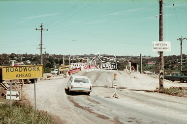
Slide, Reconstruction of Grand Boulevard viewed from Panorama Avenue, Montmorency, 18 August 1970, 1970
The Eltham Apex Club conducted a Community Service Project (1965-1968) to raise funds for a new Ambulance Station to service the community. A site bounded by the intersection of Main Road, Grand Boulevard and Looker Road at Montmorency was purchased in 1969. In 1970, Eltham Shire Council undertook roadworks to construct Apex Way in preparation for the new station as well as duplicate Main Road, Lower Plenty, east of Grand Boulevard including the new Lower Plenty Bridge, which had been opened in November 1966, bordering with the City of Heidelberg.35 mm colour positive transparency Mount - Agfacolor Service (Blue)1970-08-18, apex-diamond valley ambulance station, eltham ambulance station, eltham apex club, grand boulevard, montmorency -
 Eltham District Historical Society Inc
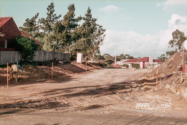
Slide, Construction of Apex Way between Looker Road and Grand Boulevard, Montmorency, 18 August 1970, 1970
The Eltham Apex Club conducted a Community Service Project (1965-1968) to raise funds for a new Ambulance Station to service the community. A site bounded by the intersection of Main Road, Grand Boulevard and Looker Road at Montmorency was purchased in 1969. In 1970, Eltham Shire Council undertook roadworks to construct Apex Way in preparation for the new station as well as duplicate Main Road, Lower Plenty, east of Grand Boulevard including the new Lower Plenty Bridge, which had been opened in November 1966, bordering with the City of Heidelberg.35 mm colour positive transparency Mount - Agfacolor Service (Blue)1970-08-18, apex-diamond valley ambulance station, eltham ambulance station, eltham apex club, grand boulevard, looker road, montmorency -
 Eltham District Historical Society Inc
Slide, Sherbourne Road overpass, Briar Hill, c.Oct 1970
Construction of new realigned Sherbourne Road railway overpass following realignment construction works for intersection of Sherbourne Road and Para Road.35 mm colour positive transparency Mount - Agfacolor Service (Blue)briar hill, bridge construction, overpass, railway bridge, sherbourne road, para road, road construction -
 Eltham District Historical Society Inc
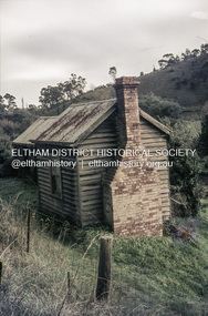
Slide, Pills Cottage, Heidelberg-Kinglake Road, Cottles Bridge, Vic, c.1970
Pills Cottage about halfway from Cottles Bridge to St Andrews near 1575 Heidelberg-Kinglake Road, St Andrews. William John "Bill" Pill was born on 19th June 1894 at Diamond Creek He was brutally murdered on 21st December 1958 age 64, in his cottage. His father was John Henry Pill, born 24 November 1856, Lalone, Perranzabuloe, Cornwall, England, He died 21 December 1930 at Cottles Bridge, His mother was Jessie Ann Whatmough, born 6th June 1870. She died 21 August 1921. William John "Bill '' Pill, grew tomatoes on his rich two and a half acres. In 2024 his second cousin Steve Whatmough recalled visiting Bill in 1957 with his parents (Eric and Nancy Whatmough) and Bill showing them his tomatoes. He had a very large aeroplane propeller set up at one end on his tomato crop. He would run the propeller on frosty mornings to keep away the frost damage. His tomatoes would ripen early and would receive a premium price for them. The cottage consisted of two buildings. The one closest in the right side of the photo was the kitchen. The second building that also has a chimney was his bedroom and living room.35 mm colour positive transparency Mount - Agfacolor Service (Blue)heidelberg-kinglake road, pills cottage, st andrews, william john pill, bill pill, john henry pill, jessie ann pill (nee whatmough), market gardener, murder, cottles bridge (vic.), tomato farm, mount - agfacolor service (blue), scan - 35mm positive -
 Eltham District Historical Society Inc
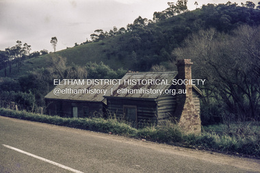
Slide, Pills Cottage, Heidelberg-Kinglake Road, Cottles Bridge, Vic, c.1970
Pills Cottage about halfway from Cottles Bridge to St Andrews near 1575 Heidelberg-Kinglake Road, St Andrews. William John "Bill" Pill was born on 19th June 1894 at Diamond Creek He was brutally murdered on 21st December 1958 age 64, in his cottage. His father was John Henry Pill, born 24 November 1856, Lalone, Perranzabuloe, Cornwall, England, He died 21 December 1930 at Cottles Bridge, His mother was Jessie Ann Whatmough, born 6th June 1870. She died 21 August 1921. William John "Bill '' Pill, grew tomatoes on his rich two and a half acres. In 2024 his second cousin Steve Whatmough recalled visiting Bill in 1957 with his parents (Eric and Nancy Whatmough) and Bill showing them his tomatoes. He had a very large aeroplane propeller set up at one end on his tomato crop. He would run the propeller on frosty mornings to keep away the frost damage. His tomatoes would ripen early and would receive a premium price for them. The cottage consisted of two buildings. The one closest in the right side of the photo was the kitchen. The second building that also has a chimney was his bedroom and living room.35 mm colour positive transparency Mount - Agfacolor Service (Blue)bill pill, cottles bridge (vic.), heidelberg-kinglake road, jessie ann pill (nee whatmough), john henry pill, market gardener, mount - agfacolor service (blue), murder, pills cottage, scan - 35mm positive, st andrews, tomato farm, william john pill -
 Eltham District Historical Society Inc
Slide, Shire of Eltham War Memorial Tower, Eltham-Yarra Glen Road, Kangaroo Ground, 24 Jul 1973
Looking east towards the tower across the western title of land purchased by Council 16 Feb. 1973 upon which the Moor-rul viewing platform and grasslands now stand.35 mm colour positive transparency Mount - Agfacolor Service (Blue)kangaroo ground, shire of eltham, war memorial tower, eltham-yarra glen road, shire of eltham war memorial -
 Eltham District Historical Society Inc
Slide, Memorial Park facilities, Shire of Eltham War Memorial, Kangaroo Ground, 24 Jul 1973
The toilet block facilities for the park and war memorial were constructed in 196535 mm colour positive transparency Mount - Agfacolor Service (Blue)kangaroo ground, shire of eltham, war memorial tower, eltham-yarra glen road, shire of eltham war memorial -
 Eltham District Historical Society Inc
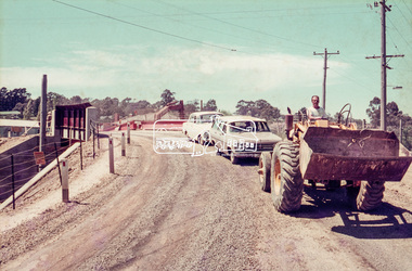
Slide, Pryor Street, Eltham, 25 Jul 1973
Looking east across Pryor Street towards the Eltham Police Station. The Police purchased the residence at 23 Pryor Street in 1959 to move from the old town centre of the late 1800s to be closer to the new town centre that shifted as a result of the railway opening in 1901. The residential house was renovated to Police requirements and operations commenced from this location in 1961. Diretly opposite and to the left of the Police Station is now a busy shopping centre car park.35 mm colour positive transparency Mount - Agfacolor Service (Blue)eltham, eltham police station, pryor street, streets, houses -
 Eltham District Historical Society Inc
Slide, Pryor Street carpark, Eltham, 25 Jul 1973
View through the Pryor Street carpark which ran between Luck and Pryor streets. The original Safeway supermarket is visible in the background off Pryor Street. Cars in the immediate vicinity are a Morris 100, and HD/HR Holden wagon and an HQ Holden35 mm colour positive transparency Mount - Agfacolor Service (Blue)eltham, pryor street, carparks, hd holden, hq holden, morris 1100, safeway supermarket, shopping centre, streets, hr holden, luck street -
 Eltham District Historical Society Inc
Slide, Luck Street, Eltham, 25 Jul 1973
Shows the entrance to the carpark which ran through to Pryor Street. A Chrysler S series Valiant at the entrance35 mm colour positive transparency Mount - Agfacolor Service (Blue)eltham, carparks, shopping centre, streets, valiant s, luck street, houses -
 Eltham District Historical Society Inc
Slide, Luck Street, Eltham, 25 Jul 1973
View looking east up Luck street from opposite the carpark entrance35 mm colour positive transparency Mount - Agfacolor Service (Blue)eltham, shopping centre, streets, luck street, houses -
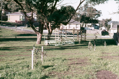
 Eltham District Historical Society Inc
Slide, Fernside Avenue Playground, Briar Hill, 25 Jul 1973
Construction of the playground in progress, viewed from Toorac Drive looking up to Fernside Avenue35 mm colour positive transparency Mount - Agfacolor Service (Blue)briar hill, fernside avenue, playground, toorac drive -
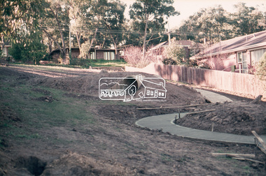
 Eltham District Historical Society Inc
Slide, Briar Valley Reserve Playground, 11 Porter Street, Briar Hill, 25 Jul 1973
Looking east through the playground to Porter Street35 mm colour positive transparency Mount - Agfacolor Service (Blue)briar hill, playground, briar valley reserve playground, 11 porter street -
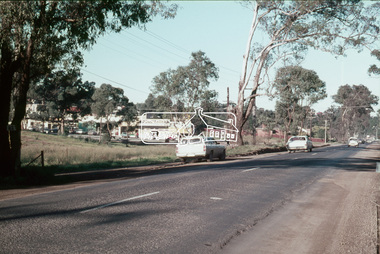 Eltham District Historical Society Inc
Slide, Main Road at Bolton Street, Eltham, 25 Jul 1973
Looking east along Main Road towards Bolton Street. Bolton street shops visible. Prior to duplication of Main Road35 mm colour positive transparency Mount - Agfacolor Service (Blue)bolton steet, bolton steet shops, eltham, main road