Showing 293 items
matching nyora
-
 Poowong Historical Group
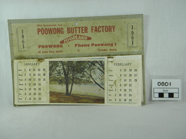
calendar, 1961 Poowong Butter Factory calendar, 1960 (estimated)
This calendar was found in a shed and is interesting because of the phone number being Poowong 1, when the telephone exchange was at the local post office. the Butter factory is no longer operating nor is the Foodland grocery store that was part of the same business.Only known calendar in existence.grubby cardboard calendar 1961 front page hanging off. centre colour picture has a small hole in it. Staples are rusted. The months January and Feb. dates printed either side of picture. Five of pictures depict seaside views and one is of a waterfall.1961, calendar, poowong butter factory, poowong foodland calendar complimentary calendar -
 Poowong Historical Group
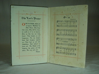
The Methodist Hymn Book, Novello and Company Limited, December 1933
This Hymn book was used at the Poowong Methodist Church that was later bought in 1984 from the Uniting Church of Australia and became the Poowong Pioneer Chapel held in trust by the Poowong Historical Group The hymn book was used by organist Cedric Hartnell at the Poowong Methodist Church from ? to 1977 when the church became part of the Uniting Church of Australia1066 pages. Worn Heavy Cardboard Bound cover. Colour grey. Spinal repair in Black velvet. Title in fading gold printInside front cover stamped "Poowong Methodist Church 1939" 2nd page in hand written script "Poowong Methodist Church 1939"book, poowong, methodist, hymn -
 Poowong Historical Group
"Pack Tracks to Pastures", The DCP Group, 2009
A valued historic publication of the Poowong area the first edition written by Ross Hartnell was no longer available.This second edition was published by the Poowong Historical Group with the inclusion of additional photos and also names to previously unnamed photographs. Some corrections to earlier text was also made. The editing and proof reading was carried out by PHG life member and brother of the author Rex Motton with the assistance of PHG life member Heather Gregg who also typeset the second edition.Second edition published 2009 by Poowong Historical Group Inc. Hard back publication. Typeset from the First edition by Heather C Gregg. Copies of this publication are still available for purchase from PHG members @ $30. pack, to, poowong, tracks, pastures -
Poowong Historical Group
"POOWONG HOME" sheet music, "POOWONG HOME"
Original Sheet Music of "Poowong Home" composed by Gladys Sandlant published ? by L.F. Collin Pty. Ltd. Melbourne.Donated to Poowong Historical Group by C Hartnell -
Poowong Historical Group
'Arthur Henry's Memoirs', 'Arthur Henry's Memoirs' The writing of an old man with a young man's mind, Published NOVEMBER 2003
20cm wide by 29cm long -
Poowong Historical Group
Poowong Consolidated School book, 'The New School on The Hill' Poowong Consolidated School 50 Years-1958-2008
Front cover and Title page by Rachel Notman Rachel's colourful picture depicts her then school, school ground, students and a backdrop of the green rolling hills of Poowong. -
 Poowong Historical Group
McDonald's Track Trek 5 April 2010 File, McDonald's Track
4 page overview of the McDonald's Track Trek 5 April 2010. Includes a map and an historical description of the track construction and the Trek notes by Rex Motton. -
 Poowong Historical Group
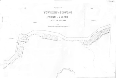
Poowong Township Map 1
Photocopy of original map - fair quality41584 pencilled on top left corner -
Poowong Historical Group
Land Title Amy Burchett and James Stroud Burchett
Land Title Amy Burchett and James Stroud Burchett 12 January 1903 4 pages2538/507545 LT L/H 3 Part of CA No. 7 Parish of Poowong -
Poowong Historical Group
'Poowong The First 30 Years' by Joseph White
-
Poowong Historical Group
'Poowong The First 30 Years' by Joseph White second edition
-
 Poowong Historical Group
Pioneer Park Images
-
 Poowong Historical Group
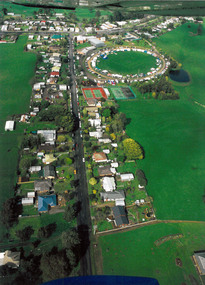
Aerial Photos of Poowong Township 200?
Aerial photograph of poowong Football Groung looking North East -
 Poowong Historical Group
School Photos
-
 Poowong Historical Group
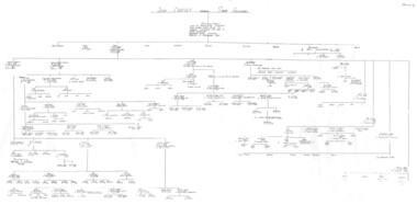
John Chaffey Family Tree
Photocopy of handwritten John Chaffey Family Tree. Some sections illegible on copy and scan. -
Poowong Historical Group
PROPOSED RAILWAY TO POOWONG. 1881, PROPOSED RAILWAY TO POOWONG
-
 Poowong Historical Group
Holy Bible
-
 Poowong Historical Group
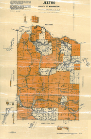
Jeetho Shire Map 6 1939
-
 Poowong Historical Group
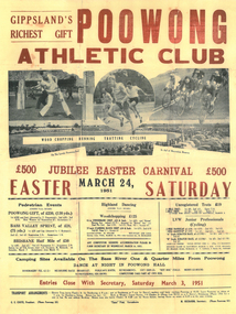
Poowong Gift 1951 Flyer
-
Glen Eira Historical Society
Letter - MARRIOTT FAMILY
This file contains three items of this family’s correspondence 1/A Carbon copy page giving details of Robert and John Marriott and John Long, from their arrival in Victoria. Includes brief history of their lives becoming councillors for the city of Caulfield. Also Robert’s early market garden business in the area, and how he established Camden Town Methodist Church. 2/A handwritten letter to Mr. Murray from Catherine Marriott dated 29th Oct (no year) 3/A Two handwritten pages of working notes in Peter Murray’s writing, author for ‘Sand, Swamp and Heath’.marriot robert, long john, gold, caulfield, councillors, st. kilda, hawthorn road, alexandra hospital, hospitals, flowers street, laura street, glen huntly road, marriot john, bambra road, field street, goe street, market gardeners, bentleigh, marriott thomas, methodist church, sunday schools, camden, hawthorn road, indoor bowling club, sporting clubs, lewis bobby, jockeys, marriott catherine, marriott arthur, hughes d, blanche mrs., stables, kooyong road, ricketson h, mallinson j, kunney m, evans john, grange road, millar w, nyora road, rate book -
Federation University Historical Collection
Plan, Plan of Mount Helen, 7/7/1964
Plan of Subdivisions to Mount Helen, Shire of Buninyong, Sheet 1 and Sheet 2 Scale 200 feet to one inchmidland highway, gear avenue, eddy avenue, shire avenue, boak avenue, moss avenue, rathkeale avenue, ingliston avenue, chatham avenue, mardango drive, nyora grove, yarana drive, shakespeare avenue, marina avenue, landale avenue, lylia avenue, recreation road, olympic avenue, the gums, heather avenue, dallas avenue, jones avenue, sebastopol mount clear road -
 Kew Historical Society Inc
Plan - Subdivision Plan, Boulevard Estate - Boulevard Section, 1930-1936
Pru Sanderson, in her groundbreaking ‘City of Kew Urban Conservation Study : Volume 2 - Development History’ (1988), summarised the periods of urban development and subdivisions of land in Kew. The periods that she identified included 1845-1880, 1880-1893, 1893-1921, 1921-1933, 1933-1943, and Post-War Development. These periods were selected as they represented periods of rapid growth or decline in urban development. An obvious starting point for Sanderson’s groupings involved population growth and the associated economic cycles. These cycles also highlighted urban expansion onto land that was predominantly rural, although in other cases it represented the decline and breakup of large estates. A number of the plans in the Kew Historical Society’s collection can also be found in other collections, such as those of the State Library of Victoria and the Boroondara Library Service. A number are however unique to the collection.The Kew Historical Society collection includes almost 100 subdivision plans pertaining to suburbs of the City of Melbourne. Most of these are of Kew, Kew East or Studley Park, although a smaller number are plans of Camberwell, Deepdene, Balwyn and Hawthorn. It is believed that the majority of the plans were gifted to the Society by persons connected with the real estate firm - J. R. Mathers and McMillan, 136 Cotham Road, Kew. The Plans in the collection are rarely in pristine form, being working plans on which the agent would write notes and record lots sold and the prices of these. The subdivision plans are historically significant examples of the growth of urban Melbourne from the beginning of the 20th Century up until the 1980s. A number of the plans are double-sided and often include a photograph on the reverse. This plan shows a subdivision with two sections: the ‘Boulevard Section’ and the ‘Riverside Section’. The first of these sections bordered Burke Road between Kilby Road and the farm beside the Yarra. Kilby Road, Munro Road, Burke Road and Old Burke Road bordered the 102 lots in the Boulevard Section of the plan. The streets within the Section included Walbundry Avenue, Inverness Way, Riverside Avenue, Cascade Street and Kyora Parade. These street names, at least in this subdivision plan linked the two Sections of the subdivision. At a later date, the City of Kew decided to alter the street names. Walbundry, Inverness, Riverside, Cascade and Kyora were all renamed as ‘Drives’ (e.g. Kyora Drive). The subdivision plan is of interest in that it names High Street in Kew as Doncaster Road. It also shows the location of the wooden church that was later removed to Yarraville on the corner of Kilby Road and High Street. The plan predates later developments such as the S. E. Dickens Supermarket.subdivision plans - east kew, boulevard estate, munro road -- kew east (vic.), kilby road -- kew east (vic.), burke road -- kew east (vic.), walbundry avenue -- kew east (vic.), inverness way -- kew east (vic.), riverside avenue -- kew east (vic.), cascade drive -- kew east (vic.), nyora parade -- kew east (vic.) -
 Victorian Railway History Library
Cauchi, Mark, Rails by the sea, 2021
The remarkable story of Kilcunda's railway history on the Nyora to Wonthaggi branch line in Victoria.index, ill, maps, p.63.non-fictionThe remarkable story of Kilcunda's railway history on the Nyora to Wonthaggi branch line in Victoria.railroad construction - victoria - history, railroad bridges - victoria - history