Showing 2735 items
matching otway-reef
-
 Otway Districts Historical Society
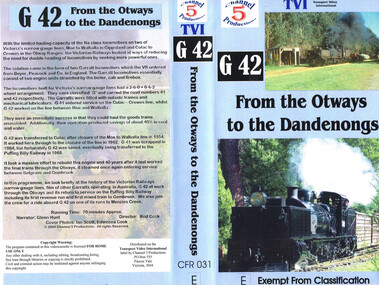
VHS Video, Channel 5 Productions, G42 From the Otways to Dandenongs, 2004
Shows footage of G42 at work in the Otways.Brief history of Australian narrow gauge lines including G42. Film of G42 at work through the Otways.g41 narrow guage railway -
 Bendigo Historical Society Inc.
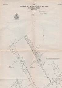
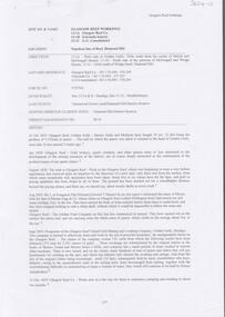
Map - STRUGNELL COLLECTION: HUSTLER'S LINE OF REEFS, September 1913
Map, Hustler's Line of Reefs, Hustler's Reef & Hustler's Reef No1 Mines Plan, Bendigo.Plate No. XV11 (17).Bulletin No 33 Signed H.A.Whitelaw.Underground Survey Office, Bendigo.map, bendigo, hustler's reef & hustler's reef 1 -
 Otway Districts Historical Society
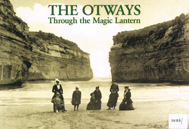
Book, Colac and District Historical Society, The Otways through the magic lantern, 2013
George Sydenham was appointed as Colac Shire Valuer and rate collector in 1890 which threw him into direct contact with the Otway people at a time when the first selectors were suffering badly. He would have heard their frustrations and grievances in great detail. When Secretary to the Colac Committee for the Railway Extension to Beech Forest he used his magic lantern slide shows from 1896 to support his case for a railway, by lauding the place and its potential, both for settlement and for timber production.The Otways through the magic lantern: commentary and glass slides of George Sydenham - lecture held in 1896. George Francis Sydenham. 1st ed. Colac (Vic); Colac and District Historical Society; 2013. iv, 118 p.; illus., map. ISBN 9780 6469 122 02 Soft cover.colac: otway ranges; history; coasts; -
 Bendigo Historical Society Inc.
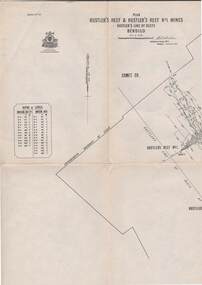
Map - HUSTLER'S REEF & HUSTLER'S REEF NO 1 MINES - PLAN OF THE HUSTLER'S REEF & HUSTLER'S REEF NO 1 MINES
Plan of the Hustler's Reef & Hustler's Reef No 1 Mines on the Hustler's Line of Reefs, Bendigo Bulletin No 33, Plate No XIV. No 8 connecting No 10 (Hustler's Reef), No 11 connecting No 13 (Hustler's Reef), No 13 (Hustler's Reef No 1) connecting No 15 (Hustler's Reef) and No 10 Hustler's Reef No 1 rise to Comet Mine. Map shows different levels in relation to the two shafts, the lines of the Hustler's Line of Reefs and the Lightning Hill Line of Reefs, the approximate Boundary of Lease and the Comet Co., the adjoining lease. Table on the left shows the levels and their depths of the two mines. Signed by H A Whitelaw, Underground Survey Office, Bendigo, September 1913. Geological Survey of Victoria emblem. mining, parish map, hustler's reef & hustler's reef no 1 mines, hustler's line of reefs lightning hill line of reefs, comet co., h a whitelaw, underground survey office bendigo, geological survey of victoria -
 Bendigo Historical Society Inc.
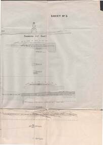
Map - STRUGNELL COLLECTION: UNDERGROUND SURVEY OF MINES BENDIGO
Map, Underground Survey of Mines, Bendigo, New Chum Railway Reef, Shenandoah Co's Shaft, Shamrock Co's Shaft.Young Chum Reef, Thorpe's Reef, Shenandoah Reef, Consolidated Reef, Sheet 3.Survey under the Supervision of H.Herman. Drawing shows mine shafts to over 3100 feet deepmap, bendigo, shamrock & shenandoah co's -
 Bendigo Historical Society Inc.
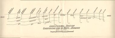
Document - AUSTIN COLLECTION: SHEEPSHEAD LINE OF REEF PLAN
BHS CollectionLongitudinal plan of the Sheepshead line of reefs, showing the mines and their sites and depths, along the reef line. Reefs marked on plan: Central Blue Reef, Freehold Reef, Big Blue Slates, Central Clue Reef and Hercules Reef. From the south of the reef : Red, White & Blue Extended, South Blue Consolidated, Old Central Blue, True Blue, Blue consolidated South Shaft, No. 3 Shaft, Blue Consolidated, North Blue, Blue United, sheepshead, Central Blue, Little 180, Ironbark South, Ironbark, Hercules. Written on bottom of plan: ' Longitudinal Section Sheepshead Line of Reefs - Bendigo'.bendigo, mining, sheepshead reef -
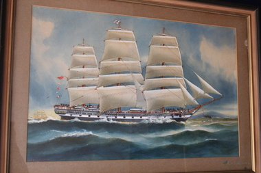 Queenscliffe Maritime Museum
Painting - Water colour painting of The Lord Warden, The Lord Warden, 1917
Arthur V Gregory b.1867, d.1957 worked from studio at 326 Albert Road South Melbourne established by his father G F Gregory in 1852Water colour painting in wooden frameThe Lord Warden passing Cape Otway 1870 A.V. Gregory-17-lord warden, a.v. gregory, water colour -
 Bendigo Historical Society Inc.
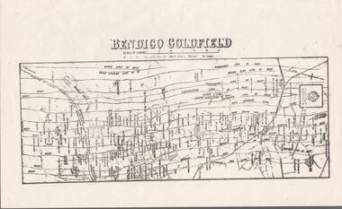
Map - BENDIGO GOLDFIELD MAP
Two not very clear copies of the Bendigo Goldfield Map. Streets, Railway Line, Lines of Reefs and mines are shown. Dept. of Mines, Victoria printed on the map. Shows reefs from Bird's Line of Reefs to Lightning Hill Line of Reef.map, bendigo, goldfields, bendigo goldfield map, lines of reefs, dept. of mines victoria -
 Bendigo Historical Society Inc.
Document - BOOKLET NOTES - SADDLE REEFS AND SPURS
Handwritten notes titled 'Saddle Reefs and Spurs'. The notes were written to replace 'The Reefs' in a previous booklet. Notes describe saddle reefs and spurs, the different terminology relating to them, why some reefs were richer than others, where the shaft was positioned relating to the reef and the description of spurs and where they occur.document, gold, booklet notes, mining, booklet notes, saddle reefs and spurs, j n macartney, bendigo goldfield registry 1870, collman, lancashire line, nell gwynne line, new chum line, sheepshead line, garden gully line, collman and tacchi, great extended hustlers, a r -
Tarnagulla History Archive
Newspaper clipping: Tarnagulla Shimmers In Golden Light, Tarnagulla Shimmers In Golden Light, August 1st, 1996
Donald Clark CollectionA clipping from the Bendigo Advertiser newspaper, article with title 'Tarnagulla Shimmers In Golden Light'. Discusses discovery of a new gold reef in South Poverty Reef by Reef Mining. tarnagulla, gold, mining, poverty reef, reef mining company -
 Bendigo Historical Society Inc.
Map - STRUGNELL COLLECTION: HUSTLER'S LINE OF REEF, September 1913
Map, Hustler's Line of Reefs, Hustler's Reef & Hustler's Reef No.1 Mines Bendigo.Plate No. X1V (14) Comet Co. .Bulletin No 33 Signed H.A.Whitelaw. Drawing shows reef boundary lines .There is an explanatory box showing depth in feet and inches of the mines .Underground Survey Office, Bendigo.map, bendigo, hustler's reef & hustler's reef 1 -
Glenelg Shire Council Cultural Collection
Accessory - Matchbook - N. L. & L. Repacholi, n.d
Matchbook, cardboard, red and white VISCOUNT advertising on front, N.L. & L. REPACHOLI, 45 OTWAY ST, PORTLAND on reverse.local industry, business, advertising, matchbook -
Bendigo Historical Society Inc.
Archive - MCCOLL, RANKIN AND STANISTREET COLLECTION: NELL GWYNNE REEF - MINING BOX
Mining Box. Metal painted green with Nell Gwynne Reef painted on the lid. Nell Gwynne Reef Box number 486, now Nell Gwynne Reef Box 10mining, mining box, mccoll, ranking & stanistreet -
Bendigo Historical Society Inc.
Document - CARSHALTON REEF, DIAMOND HILL MINES
Table of information regarding the mines situated along the Carshalton line of Reef, includes Stafford Reef mine.bendigo, mining, carshalton reef line -
Glenelg Shire Council Cultural Collection
Clothing - Collar box and collars, n.d
a) Brown, rectangular cardboard box, marked 'Collars and ties'. Leather straps, inside black and white check. b - v) 21 collars, plain, striped and checked Identification numbers 7480 a - vFront: 'Betty Vivian, 22 Otway Street Portland' handwritten inside lid -
Glenelg Shire Council Cultural Collection
Award - Trophy - Syd Cuffe, Town Crier, n.d
Syd Cuffe was the Portland Town Crier from 1983 to 2013. The role of Town Crier was created for Syd Cuffe in 1983 in the lead up to Portland’s 150th anniversary celebrations held in 1984-85. 200 items from Mr. Cuffe’s estate were donated to the Glenelg Shire Cultural Collection. The items relate to his town crying activities and community work across the Shire and further afield.Trophy, clear perspex, Colac Otway Shire 3rd place, 10th Victorian Town Crier Championships, 4 Nov 2001. -
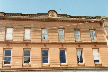 Stawell Historical Society Inc
Photograph, McKellar Building in Upper Main Street Stawell in c 1992
Coloured photo McKellar Building c 1876. The colour photo was taken in 1992. The information in Album 4 page 40 states the building was built after fires of c 1866 & 1874. Mr. George Inskip was the architect of the McKellar building.Two colour copies of the McKellar building taken by Geoff Oates in 1992. The two identical photos just show the upper two stories of the building. Stawell 1876 Building Gold Reef Mall. Nov 1992 stawell business -
Stawell Historical Society Inc
Map, Gold Mines of Australia, Stawell Investment Geological Plan. Mine Area showing Mineshafts
The Reefs Mine shaft locationsGold Mines of Australia Ltd mining, gold, map -
 Bendigo Historical Society Inc.
Map - STRUGNELL COLLECTION: HUSTLER'S LINE OF REEFS, September 1913
Map, Hustler's Line of Reefs, Hustler's Reef & Hustler's Reef No.1 Mines Plan.Plate No. XV1.(16) Sheet 2 .Bulletin No 33 Signed H.A.Whitelaw.Underground Survey Office, Bendigo, September,1913. Included is the emblem of the Geological Survey of Victoria. Drawing shows a plan view of reefs and shaft locations .Underground Survey Office, Bendigomap, bendigo, hustler's reef & hustler's reef 1 -
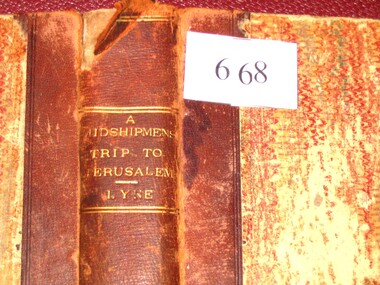 Stawell Historical Society Inc
Book, Augustus A. Lyne R.N, A Midshipman’s Trip to Jerusalem, 1871
This book at one time belonged to the Pleasant Creek Library and Mechanic Insititute, Quartz Reefs. The Adventures of a cavalcade of British Naval Officers in the Holy Land. Dedicated by permission to: Captain George Lethbridge R.N. and the Officers of H.M.S. TrafalgarBrown Spine and Cornors, front and back patterned paper cover, part missing, clear tape on spine top and bottom. Top Right Inside Cover J.W. Evans & Co. Binders 11A Flinders Way. Notice pasted on inside of front Cover. No. 1313. Pleasant Creek Library and Mechanics Institute Quartz Reef. Members will be held responsible for any damage done to books in their possession.stawell education -
Stawell Historical Society Inc
Book, Stawell Mining Co
Town Western Reefs Tyne Co. Township Reefs. Newspaper Reports from the Pleasant Creek News 1868 -1909gold mining -
 Bendigo Historical Society Inc.
Photograph - JOHN HALL COLLECTION: PHOTO OF THE ORIGINAL WATER COLOUR PAINTING: HUSTLERS REEF
JOHN HALL COLLECTION: PHOTO OF THE ORIGINAL WATER COLOUR PAINTING: Hustlers Reef Written on the rear Hustlers Reef 2John Hallartwork, water colour, gold mines -
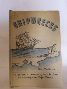 Flagstaff Hill Maritime Museum and Village
Book, Shipwrecks
Margaret MacKenzie had first hand knowledge of many shipwrecks along Victoria's treacherous 'shipwreck' coast. In her later years her failing sight caused her to attend the nearby eye specialist Dr W.R. Angus in Warrnambool. Dr Angus designed the cover for Margate's book. Margaret's daughter assisted in the writing due to her mother's failing sight.Shipwrecks by M.E. MacKenzie, part of the W.R. Angus Collection. An authentic account of wrecks from Peterborough to Cape Otway, Victoria. Cover printed in blue, black and white, depicts sailing ship approaching cliffs, and a map of the coast of south west Victoria, showing Peterborough and Cape Otway. Art work for cover was done by Dr. W.R. Angusflagstaff hill, warrnambool, shipwrecked-coast, flagstaff-hill, flagstaff-hill-maritime-museum, maritime-museum, shipwreck-coast, flagstaff-hill-maritime-village, shipwrecks, m e mackenzie, peterborough, cape otway, shipwreck coast, book, w.r. angus -
 Otway Districts Historical Society
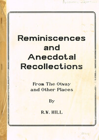
Book, R.W. Hill, Reminiscences and anecdotal recollections. R.W. Hill
Reminiscences and anecdotal recollections from the Otways and other places. R.W. Hill. 1st Ed. No imprint. iii, 49 p. Soft cover.Letter from R.W. Hill to Anthony Zappelli of Beech Forest.reminiscences; anecdotes; recollections; otways; beech forest; the ridge; -
 Bendigo Historical Society Inc.
Document - ALBERT RICHARDSON COLLECTION: VICTORIA HILL
Sixteen-page document with details about Victoria Hill, Victoria Spurs, East Victoria Reef, Try Me Well Reef and Hercules Reef. (ref: Dicker's Mining Record 23rd November 1861) Wittschiebe & Co's Claim Victoria Hill, Victoria Reef Gold Mining Company and Victoria Quartz are mentioned.bendigo, mining, victoria hill -
 Bendigo Historical Society Inc.
Document - WILSON'S REEF STATE SCHOOL, 1/10/1873
Document, Wilson's Reef State School, Welcome Back Brochure. Wilson's Reef was about 3 - 5 kilometers from Marong.document, invitations, wilson's reef -
Stawell Historical Society Inc
Map, Special Allotments, Reefs, Pleasant Creek
Special Allotments, Reefs, Pleasant Creekstawell -
 Bendigo Historical Society Inc.
Map - REEF MAP OF BENDIGO
Large coloured map of reefs in Bendigo.bendigo, mining -
 Bendigo Historical Society Inc.
Document - GLASGOW REEF WORKINGS DIAMOND HILL
One page document detailing the Glasgow Reef workings on the Napoleon Reef, Diamond Hill. Report prepared by David Bannear. Mining companies mentioned in the report are Glasgow Reef Co., Golconda Battery and the Glasgow Golconda Consolidated Mine.bendigo, mining, glasgow reef workings -
 Halls Gap & Grampians Historical Society
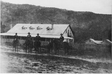
Photograph - B/W, C 1918
Men in front of Myrtlebank Guesthouse.Four men on horseback and one man standing, in front of guest house108 m CNNA 10A06 Dec 99 Gold reef Photosaccommodation, guesthouses, myrtlebank