Showing 22313 items
matching parks
-
 Kew Historical Society Inc
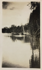
Photograph - Yarra River, Studley Park, 1924
Henry Beater Christian (1886-1962) , was a descendant of one of the earliest settler families in Kew. Employed at the Kew Asylum as a 'public servant', he was a skilled amateur photographer, photographing numerous scenes in Kew and on his travels around Victoria. The majority of his photographs date from 1916 to 1929. His finest photographs are housed in two photograph albums. Digital copy of a photograph from page 7 of the 47-page photograph album containing 261 gelatinous silver images, loaned by Diane Washfold with permission given to digitise and hold a copy in our collection. This photograph shows a covered tourist ferry moored on the river bank at Studley Park. Tourist cruises traversed the Yarra between Princess Bridge and Heidelberg, stopping at scenic points along the journey. "Studley Park / Kew"henry beater christian (1886-1962), landscape photography, kew (vic.) — yarra river, christian-washfold collection, photograph albums, kew, ferries, tourism, studley park -
 Clunes Museum
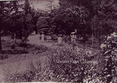
Photograph
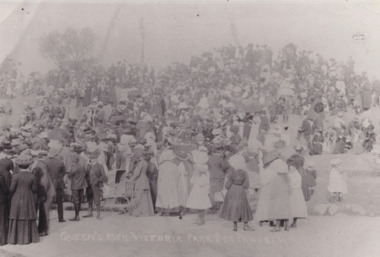
.1 ORIGINAL BLACK & WHITE PHOTOGRAPH, VIEW OF QUEEN'S PARK CLUNES. LADY AND TWO YOUNG GIRLS NEAR FOUNTAIN. ..2 REPRINT OF THE ORIGINAL PHOTOGRAPH .3 POSTCARD SIZE REPRINT OF THE ORIGINAL PHOTOGRAPHQUEENS PARK CLUNES IN WHITE WRITING IN THE MIDDLE OF THE IMAGElocal history, queen's park garden -
 Stawell Historical Society Inc
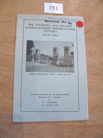
Book, N.A. McLennan, The Founders and Records, Marnoo Soldiers Memorial Park Victoria 1919 - 1965 by N A McLellan, 1965
About the founding of the Marnoo Soldiers' Park. THe Meaning of Marnoo, where Is Marnoo?, and the People involved.Pale blue Card with black Border inside of which is black text and b/w of a iron gate and four stone pillars.The Founders and records Marnoo Soldiers' Memorial Park Victoria 1919 -1995 Marnoo Memorial Park Gates Photo Taken 1963 Complied and written for the Marnoo Soldiers' Park Committee. by N.A. McLennan 9th September, 1965stawell ww1 ww2, mclennan family -
 Federation University Historical Collection
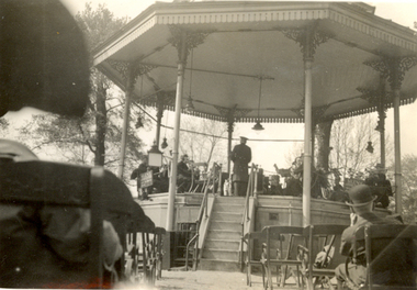
Photograph - Black and White, St Hilda's Band at Hyde Park, London, May 1934, May 1934
Frank Wright was a renown resident of Smeaton, where he was born. He lived at Laura Villa, and attended Smeaton State School. His father William was a gold miner and his mother's name was Sarah. Their family won many singing and instrumental awards. Frank was tutored by Percy Code and was awarded a gold medal for the highest marks in the ALCM examinations in the British Colonies at the age of seventeen years. He became the Australian Open Cornet Champion by the age of eighteen. A year later, Frank conducted the City of Ballarat Band, and later the Ballarat Soldiers’ Memorial Band. He formed the Frank Wright Frisco Band and Frank Wright and his Coliseum Orchestra. These bands won many South Street awards, and Frank as conductor won many awards in the Australian Band Championship contest. In 1933 Frank Wright sailed to England to conduct the famous St Hilda’s Band and was later appointed Musical Director of the London County Council, where he organized many amazing concerts in parks, in and around the London district. He was made Professor of Brass and Military Band Scoring and conducted at the Guildhall of Music and Drama. Frank was often invited to adjudicate Brass Band Championships around Europe, in Australia, including South Street and in New Zealand. The Frank Wright Medal at the Royal South Street competition is awarded to an individual recognized as making an outstanding contribution to brass music in Australia.Black and white photograph of a rotunda situated in Hyde Park, London. A band is seated within the rotunda with the conductor standing at the front. In the foreground are seats with a couple of spectators. The band is St Hilda's and the conductor is Frank Wright.Written in pencil on back - Frank Wright Conducting St Hilda's Band, Hyde Park, London, May 1934frank wright, cornet, conductor, london, rotunda, st hilda's band -
 University of Melbourne, Burnley Campus Archives
Plan - Photocopy, Horticultural Society of Victoria's Experimental Gardens, 1888, 1888
... parks ...Photocopy of Plan of Richmond stretching N past Barkers Rd., W to Stawell St. E past Power St and S below Richmond Park - takes in loop in river around the Horticultural Society's Garden and Richmond Park. This plan was used in the Burnley College Centenary display. richmond, parks, centenary, experimental gardens, hoticultural society of victoria -
 Vision Australia
Photograph - Image, Royal Blind Society of New South Wales
Colour photograph taken of the Royal Blind Society of New South Wales building in Enfield, as viewed from Henley Park. A red buildng with grey stairwells and window fixtures, surrounded by a concrete balcony that overlooks the park. Digital Image of Enfield building taken from parkroyal blind society of new south wales, buildings -
Lakes Entrance Historical Society
Book, Le Cheminant, Marion, Nyerimilang and its Neighbourhood, 1985
... Parks ...A history of Nyerimilang Homestead on the Gippsland Lakes at Kalimna West, from 1884 to 1985. Now the responsibility of National Parks.settlers, agriculture, timber industry, waterways, parks -
 Greensborough Historical Society
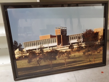
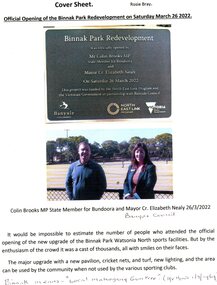
Article - Article and Leaflet, Rosie Bray et al, Official opening of the Binnak Park redevelopment on Saturday March 26 2022, July 2020 , November 2021 and March 2022
An upgrade at Binnak Park Watsonia will improve facilities for the Plenty Valley Cricket Club and Watsonia Sporting Club , which have been displaced from A K Lines Reserve by construction of the North East Link, Binnak Park to continue their activities5 p. comprising 4p. North East Link "Binnak Park Community Update" 2020, with Cover sheet by Rosie Bray and colour photograph of the park at openingbinnak park, banyule parks, binnak park watsonia, north east link -
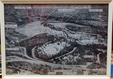 Kew Historical Society Inc
Photograph, Yarra Bend Park Trust, Yarra Bend Park Facilities, 1940s
Old aerial photograph of Yarra bend Park labelled with park facilitiesFramed annotated aerial photograph of Yarra Bend Park. The white frame is original to the work.yarra bend park, sports facilities - kew - fairfield, sir herbert olney oval, fairfield hospital, chandler bridge, deep rock swimming basin, kane's footbridge -
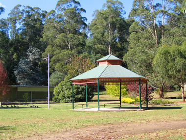 Marysville & District Historical Society
Photograph (Item) - Colour photograph, Travel Victoria, 2006
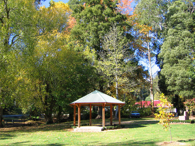
A colour photograph of the rotunda in Lions' Park in Marysville in Victoria.A colour photograph of the rotunda in Lions' Park in Marysville in Victoria.marysville, victoria, photograph -
 Marysville & District Historical Society
Photograph (Item) - Colour photograph, Travel Victoria, 2006
A colour photograph of the rotunda in Lions' Park in Marysville in Victoria.A colour photograph of the rotunda in Lions' Park in Marysville in Victoria.marysville, victoria, photograph -
 Marysville & District Historical Society
Postcard (item) - Advertising postcard, GREETINGS FROM Maryton Park MARYSVILLE, Unknown
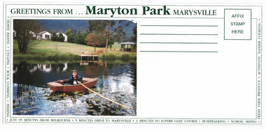
An advertising postcard from Maryton Park near Marysville.An advertising postcard from Maryton Park near Marysville.marysville, victoria, australia, maryton park, accommodation, advertising postcard -
 Marysville & District Historical Society
Postcard (item) - Advertising postcard, GREETINGS FROM Maryton Park MARYSVILLE, Unknown
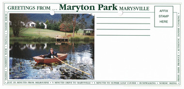
An advertising postcard from Maryton Park near Marysville.An advertising postcard from Maryton Park near Marysville.marysville, victoria, australia, maryton park, accommodation, advertising postcard -
 Marysville & District Historical Society
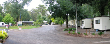
Document (Item) - List of rules, Larry and Margaret Richmond, MARYSVILLE CARAVAN PARK-RULE OF THE PARK, Unknown
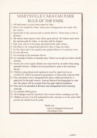
A list of rules for guests staying at the Marysville Caravan Park.A list of rules for guests staying at the Marysville Caravan Park.marysville, victoria, australia, marysville caravan park, rule of the park -
 Kiewa Valley Historical Society
Maps 3D - National Parks
Used by the employees of National Parks. The maps show the topography and contours in 3D when used with the stereoscope KVHS 0743. This enables the photographed area to be compared to previous photos and enables the planning of construction of eg. new roads etc. Digital information is now available.These photographs give the topography and contours of vast local areas eg. Mt Feathertop and Tawonga township.when used with a stereoscope. Black and white large aerial photos of the Bogong High Plains area. 14 to 20 of them all on thick paper and the same size as the brown wooden box which holds them. The box hasn't got a lid at the top.Identified and catalogued by National Parksmaps showing topography, national parks, stereoscope -
 Stawell Historical Society Inc
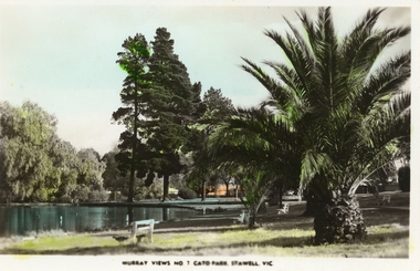
Photograph, Cato Lake -- with palms & trees -- Coloured
Coloured Postcard Murray Views No. 7. Cato Park Stawell Victoria. The three black and white photos are missing the larger palm tree on the right in the foreground. The view is of the lake surrounded by trees and bench seating. One colour post card Murray View No 7 Cato Park Stawell Victoria plus two similar black & white photos one smaller the other an enlargement. Also a small B&W photograph in Album 14, p28. The post card is a view of a section of the lake surrounded by willows, 2 tall pine trees and one large palm tree on the right. The lake is also surrounded by 3 concrete & wood bench seats with maybe a 4th in the distance. Murray View No 7 Cato Park Stawell Vic. On the back "Post Card Real Photograph produced in Australia by Murray View, Gympie, Q".stawell -
 Uniting Church Archives - Synod of Victoria
Photograph, c1910
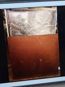
J. W. Stares was the pastor of the Prince of Wales Park Methodist Church, 1914 - 1918.Sepia toned studio head and shoulders portrait of Mr. Stares, aged between his late 20s and mid 30s. He is at a slight angle to the camera and is looking past it. His face is in half shadow.In pencil on the back: "MR STARES ?Prince of Wales Park"pastor j. w. stares methodist, prince of wales park methodist circuit, northcote (prince of wales park) -
 Rutherglen Historical Society
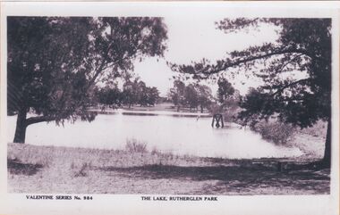
Image, c1900
"The Lake, Rutherglen Park" is now called Lake King, and was originally established as water storage for the town. The photograph is taken from the side of the lake that is currently occupied by the caravan park.One of three black and white photographs mounted on orange paper. This one is a view of Lake King.Printed at bottom of photo: "Valentine Series No. 984 The Lake, Rutherglen Park"lake king, rutherglen park -
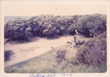 Port Fairy Historical Society Museum and Archives
Photograph, Battery Hill 1973
East Beach car park in the 1970’s Coloured photograph of Battery Hill car park surrounded by treesbattery hill, car park, east beach, tea tree -
Lakes Entrance Historical Society
Book, Discovering the Prom. on Foot, 1986
... Parks ...A guide to 22 walks including four nature walks in Wilson's Promontory National Park. Includes photographic reproductions, maps and sketches to assist in identification of flora and fauna.parks, natural history, topography, vegetation -
University of Melbourne, Burnley Campus Archives
Plan, City of Richmond Development of Old Burnley School Site, c. 1986
... parks ...Plan for Park - area bounded by Madden Grove, Parkville, Stawell and Gibdon Streets Richmond. Scale 1:200. CP-72047186.richmond, burnley, burnley school, parks, golden square bicentennial park -
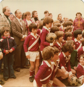 Ballarat Heritage Services
Photograph - Colour photograph, Opening of the Soccer Pavilion in Kew, 1980, 1980
In 1981 the South Melbourne United club moved away from Middle Park to Kew, becoming Kew Park Rangers, eventually merging with Moreland at the end of 1985 to form Moreland Park Rangers.A number of soccer players of the Kew Park Rangers Soccer Club and men at the opening of the soccer pavilion. city of kew, stranbroke park, alan hutchinson, john hogan gervasoni, jack gervasoni, rupert hamer -
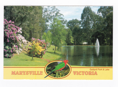 Marysville & District Historical Society
Postcard (item) - Colour postcard, Neil Cutts, Marysville Victoria-Gallipoli Park & Lake, Pre 2009
A postcard in a series produced by the Rose Stereograph Company in Victoria, Australia as a souvenir of Marysville.A colour photograph of Gallipoli Park and Darmody's Lake in Marysville, Victoria. Darmody was a prominent builder at one time in Marysville and this lake was named after him. The Rose Series postcard No. 3529.MARYSVILLE VICTORIA/ Gallipoli Park & Lake POST CARD The "Rose" Series/ De Luxe Proudly Printed in/ Australia Since 1880 AFFIX/ STAMP/ HERE/ Rose Series/ Post Card No./ 3529 ADDRESS/ POSTCODE Beautiful Gallipoli Park and Lake/ MARYSVILLE, VICTORIA, AUSTRALIA/ Photos Neil Cutts Copyright Rose Stereograph Co., Glen Waverley, Victoria (03) 9560 7772marysville, victoria, gallipoli park, postcard, souvenir, rose stereograph co, 3529, darmody's lake -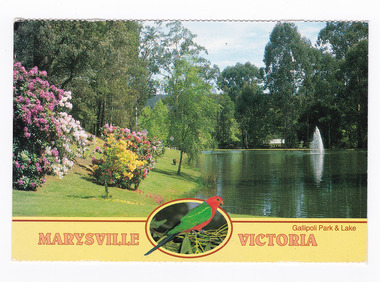
 The Beechworth Burke Museum
Postcard, c. 1903
Taken in c. 1903, depicted is a large group of adults and children dressed in formal attire gathered around and upon the granite rock in the centre of Queen Victoria Park.Originally known as the Beechworth Botanical Gardens, Queen Victoria Park features a extensive collection of historic trees and plants, which have been listed on the Indigo Shire’s Significant Tree Register.Black and white rectangular postcard printed on cardObverse: QUEEN'S ROCK VICTORIA PARK BEECHWORTH Reverse: 3701/ 3641 (this has been crossed out)/ Parks & Gardens/ 1998.00059/ entertainment album, burke museum, beechworth, queen victoria park, gardens & parks -
Kew Historical Society Inc
Badge, Kew Canoe Club, KCC Studley Park Kew, Twentieth Century
A small shield with overlapped KCC on a blue ground, mounted on a wider ribbon shaped banner containing Studley Park also on a blue ground either side of a pair of oars with Kew on a blue ground between the blades of the oars.KCC STUDLEY PARK KEW on reverse STOKES & SONS MELBbadges - rowing - kew (vic), sports - kew (vic), kew canoe club -
 Federation University Historical Collection
Document, History of the Ballarat Technology Park, Oakbank
The Ballarat Technology Park is associated with Federation University Australia. The first stage commenced on 03 August 1989 when the first sod was turned by Hon, David White, Minister for Industry, Technology and Resources. John Beaumont was the Director of the Ballarat Technology Research and Development Park in 1989.Twenty items relating to the History of the Ballarat Technology Park as collected by John Parkin. .1) Handwritten notes by John Parkin on the history of the Ballarat Technology Park .2) Letter from A.E. Helyar (Shire of Buninyong Secretary), 08 March 1988 .3) Shire of Buninyong Minutes 07 June 1988 .4) Development of High Technology Activity by Jack Barker .5) Definition of a Technology Park by Derek Woolley .6) Shire of Buninyong minutes 28 June 1988 .7) Shire of Buninyong minutes 19 July 1988 .8) Invitation to a reception to commemorate the inauguration of the Ballarat Technology Park (John Parkin) by Shire of Buninyong President Cr Judith Coull to be held on 03 August 1989. .9) Invitation to a reception to the Ballarat Technology Park (John Beaumont) .10) Ballarat Courier article 04 August 1989 .11) Draft letter to Professor Geoffrey Blainey from John Parkin .12) Letter to the Editor from John Parkin, 18 December 2000 .13) University of Ballarat Development Appeal, 04 November 1994 .14 & .15) Invitation to installment dinner to celebrate the installation of Professor Geoffrey Blainey as Chancellor of the University of Ballarat to be held in the Union Building (now Albert Coates Building), Mt Helen campus .16) Letter to the editor from John Parkin .17) Letter from John Beaumont, 25 November 1994 .18) Invitation to the opening of the ISSC Southern Region Data Centre to be held on 24 November 1995. .19) Letter from Barry Traynor, 13 December 1995 .20) Planning Scheme information relating to the LaTrobe Research and Development Zone. .1) 2nd May 2005 History of Technology Park (I.T. centre) The history of the Technology Park started back in the mid-1980s. At the time I was a Buninyong Shire Councilor and as such I was Buninyong's representative on the then Ballarat Development Committee. At one of our meetings we received a request for information on a suitable site for a technology park. The requirements were for a site adjacent to a tertiary institution, secluded for security purposes and large enough to contain such a development. The next morning I contacted our Shire Engineer at the time, Newell Barrett and we drove around the area we both agreed that the current site was the most suitable we saw to meet the requirements. At the time it was owned by George Morrison. however the original enquiry to the B.D.C. came to nothing but the Shire Council and the B.D.C. decided to investigate the possibility of the site becoming a technology Park and information was collected. At about this time Mr Morrison put the property on the market and it was bought by a Ballarat builder, Mr John Beaumont, with the idea of developing it as a residential area. Council then arranged a meeting with Messrs Morrison and Beaumont to discuss the matter. I remember Mr Morrison saying he did not care what was done with it he just wanted to sell it and move down to the coast. Mr Beaumont, on the other hand, said he wasn't ready to retire yet and the idea interested him. As a result a committee consisting of the B.C.A.E., B.D.C. and Buninyong Shire Council (and Mr Beaumont) was formed to plan the development and rezone the area to technology park. It was previously zoned residential land and would seem to have been suitable for sub-division and residential development - its close proximity to the College being a major factor in its favour. The point of this is if Mr Beaumont had insisted on pursuing his original plan and had opposed the rezoning, I am quite confident he would have won an appeal at the A.A.T . (Administrative Appeals Tribunal - forerunner of V.C.A.T.) and the I.T. centre would not have got off the ground and the area would be covered with houses. But Mr Beaumont did go into the project with enthusiasm and the first stage was commenced on the 3rd August 1989 when the first sod was turned by Hon. David White, the Minister for Industry, Technology and resources (See the Courier 4th August 1989) Mr Beaumont went overseas to study similar parks and look for tenants. Unfortunately government did not support the project as they have now and apparently Mr Beaumont was ahead of his time for the private sector so Mr Beaumont could not continue the development and the site eventually passed to the College. I personally think more could have been done ... The work done by the Buninyong Shire Council and Ballarat Development Committee seems to have been forgotten as according to the Courier December 21, 2000 we are told the Park opened in 1995 as a joint venture between the City and the University. As a former Councillor said to me on the day "What happened to the plaque David White unveiled in 1989!" If there is any other information you want, please contact me. You may use my file for reference. Kind regards John Parkin PS I always felt a bit guilty that I encouraged John Beaumont and he was left in the lurch. ballarat technology park, parkin, john parkin, helyar, barker, woolley, shire of buninyong, beaumont, blainey, geoffrey blainey, southern region data centre, greenhill enterprise centre, stan jeffrey, jeffrey, john beaumont, david white -
Federation University Historical Collection
BTV8, Ballarat Technology Park Approved, 1988, 1988-1990
David Wright turns the first sod for the Ballarat Technology Park.MP4 of a BTV6 newsclip of the approval of the Ballarat Technology Park Approved.ballarat technology park, john sharpham, beaumont, mt helen, david wright, ballarat regional board, john beaumont, ballarat college of advanced education, ballarat university, bob hawke -
 Marysville & District Historical Society
Photograph (Item) - Colour photograph, Unknown
A digital copy of a colour photograph of the entrance to the Marysville Caravan Park.A digital copy of a colour photograph of the entrance to the Marysville Caravan Park.marysville, victoria, australia, marysville caravan park, photograph -
 University of Melbourne, Burnley Campus Archives
Photograph - Colour prints, Photograph Collection of Potential Careers
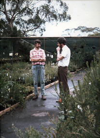
... parks ...Photographs mounted on heavy cardboard for a display. (1) Nursery with 2 men, "Nursery Trade" handwritten on reverse. (2) Nursery with man and child, "Nursery Trade" handwritten on reverse. (3) Construction site with 1 man, "Landscape Design" handwritten on reverse. (4) Park with 3 men, "Parks and Gardens" handwritten on reverse. (5) Private gardennursery, men, children, parks, gardens