Showing 278 items
matching plenty - maps
-
 Kiewa Valley Historical Society
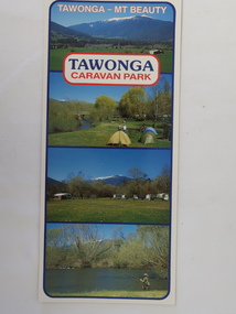
Brochure - Tawonga Caravan Park, Tawonga - Mt Beauty
Tawonga Caravan park is on the Kiewa River situated north of Mt Beauty and 30 km from Falls Creek. Tawonga Caravan park has always been popular for families and fishermen with plenty to do.Colored cardboard brochure with 3 small photos on the front and information printed on the back with a small map.tawonga caravan park, trout fishing -
 Eltham District Historical Society Inc
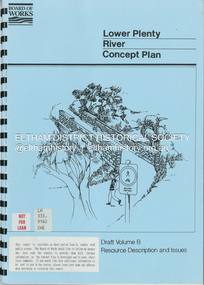
Book, Brett Cheatley et al, Lower Plenty River Concept Plan; Maroondah Pipetrack - Greensborough to Yarra/Plenty Confluence; Draft Volume B, Resource Description and Issues, February 1991
concept plan, melbourne metropolitan board of works, plenty river, report -
 Melbourne Tram Museum
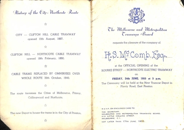
Ephemera - Invitation, Melbourne & Metropolitan Tramways Board (MMTB), "Official Opening of the Bourke Street - Northcote Electric Tramway", Jun. 1955
Printed invitation on off-white card with MMTB letter head invitation to the "Official Opening of the Bourke Street - Northcote Electric Tramway", Friday 24th June 1955 at 3pm at the new tramcar depot in Plenty Road Preston. Has been handwritten for "H. S. McComb Esq." in blue ink. Has a map of the route, the Nicholson St line show dotted and schedule for completion in 1956, details of the project and a brief history of the route.trams, tramways, opening, civic functions, bourke st, preston depot, northcote, cable trams -
 Ballarat Tramway Museum
Magazine - Australian Railway Enthusiast - Vol 31, No. 1, Jim Seletto, "Memories of the Railway Trams", March 1993
Contains a detailed article on both the VR lines by Jim Seletto, featuring photos of 39, 30, 53, 49, MMTB 675 and a colour photo of VR 49 on the rear. Contains maps and diagrams of St Kilda Station. Includes Sandringham and Black Rock line. Published by the ARE.Provides a light hearted record and view of the VR Railway trams with plenty of stories..Magazine - "Australian Railway Enthusiast - Vol 31, No. 1, March 1993", 24 pages, centre stapled,vr trams, st kilda - brighton tramway, sandringham, black rock, maps, st kilda, tramways, railways -
 Eltham District Historical Society Inc
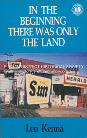
Book, Len Kenna, In the beginning there was only the land, 1988
A book, published as part of the Australian Bicentenary Celebrations on the history of the suburb of Bundoora. ... Includes photographs, maps and index. Local history of the outer Melbourne suburb of Bundoora, from the original Wurundjeri people through to its development as a thriving suburb in the 1980s ; section entitled "The Aborigines" (pp.14-21) discusses the traditional way of life of the Wurundjeri people prior to European settlement.bundoora, bundoora hall, hospitals, jane mckimmie, janefield, janefield church, john mckimmie, la trobe university, marvellous melbourne, mont park, mont park psychiatric hospital, plenty river, william shillinglaw, wurundjeri, yan yean reservoir -
 Melbourne Tram Museum
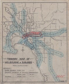
Drawing, H. S McComb, "Tramway Map of Melbourne & Suburbs", mid 1930's
Set of 19 drawings showing the development of the Melbourne tramway system between 1885 and 1921. Based on MMTB drawing "Tramway Map of Melbourne & Suburbs" P4609, 18 sheets showing year by year development of the cable and electric tram system, printed on off white paper. Mr. McComb had intended it would appear to do further work - with some 20 sheets printed on brown card paper but not used (.19 - same drawing) Each sheet has the year in red at the bottom right hand corner of the sheet. .1 - 1885 - with the Richmond line and main rail lines coloured in showing a catchment area. .2 - 1886 - shows the new cable line in Collins St and has a note that no suburban line constructed in 1886 .3 - 1887 - Bourke and northern lines and Brighton Beach to Sandringham and Hawthorn to Kew .4 - 1888 - Swanston St, Domain Road, Chapel and inner circle and towards Hurstbridge.\ .5 - 1889 - Rathdown St and Toorak Road .6 - 1890 - South and Port Melbourne, North Melbourne and Northcote. Rail lines - Ashburton and parts of the outer circle to Oakleigh. .7 - 1891 - St Kilda Esplanade and northern section of the outer circle. .8 - 1906 - NMETL .9 - 1910 - PMTT - High St and Wattletree Road .10 - 1911 - PMTT Dandenong Road .11 - 1913 - Glenferrie Road, Cotham Road, Balaclava and Glenhuntly Road .12 - 1914 - small extension in High St .13 - 1915 - Malvern Road and High St Kew .14 - 1916 - HTT and MBCTT lines and Whitehorse Road .15 - 1917 - Burke Road .16 - 1918 - Burke Road north of Camberwell station .17 - 1920 - FNPTT - St Georges Road and Plenty Road .18 - 1921 - Footscray lines .19 - base drawing only. Does not show the VR tramlines. See Reg Item 2154 for associated notes.See individual sheets.trams, tramways, times, cable trams, railways, tramways, melbourne, maps -
 Melbourne Tram Museum
Document - Report, Parliamentary Public Works Committee, "Parliamentary Public Works Committee Report Plenty Road, Preston, Tramway Extension Enquiry, 1967
... Committee Report (including map) on The Plenty Road, Preston... Committee Report (including map) on The Plenty Road, Preston ...Report contained within a light brown card folder, containing a photocopy of report titled "Parliamentary Public Works Committee Report (including map) on The Plenty Road, Preston, Tramway Extension Enquiry - 1967". Report stapled in top right hand corner, 15 pages examining the extension of the East Preston route to Bolderwood Parade. Map shows extension proposed, bus routes, railway lines, streets - folded into 4.AETA stamp on front and inside sheet and "4E6" in ink on front cover. AETA stamp on the bottom right hand corner of the map.trams, tramways, east preston, new tramway, bolderwood parade, proposals -
 Greensborough Historical Society
Pamphlet, Lower Plenty Shopping Centre, 2007
... with list of shops, map and 2008 Calendar lower plenty shopping ...Coloured pamphlet from Lower Plenty Shopping Centre with list of shops, map and 2008 CalendarColour pamphlet with calendar and maplower plenty shopping centre, calendars, lower plenty