Showing 632 items
matching river st
-
 Ballaarat Mechanics' Institute (BMI Ballarat)
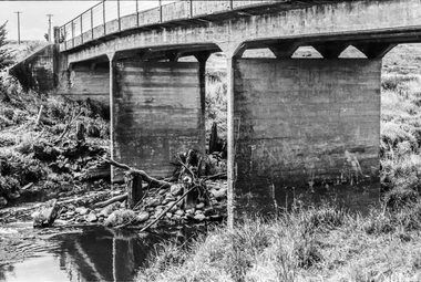
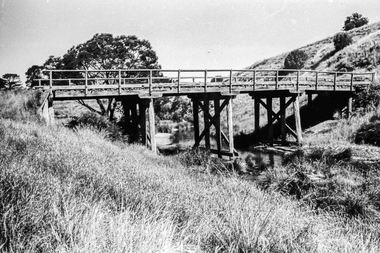
Film - Photograph by Herb Richmond. ca 1971, Scotchmans, Concrete Road Bridge Over the Yarrowee River, Between Napoleans and Buninyong
Ballarat History35mm B&W Kodak Plus X Pan Film.ballarat, ballaraat, scotchmans, bridge, yarrowee, river -
 Ballaarat Mechanics' Institute (BMI Ballarat)
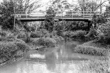
Film - Photograph by Herb Richmond. ca 1971, Yendon Blue Bridge- Road Bridge over the Moorabool River
Ballarat History35mm B&W Kodak Plus X Pan Film.ballarat, ballaraat, yendon, bridge, moorabool -
 Ballaarat Mechanics' Institute (BMI Ballarat)
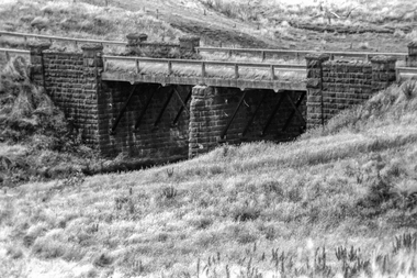
Film - Photograph by Herb Richmond. ca 1971, Pitfield Bridge- Over the Woady Yalloak River, South of Cape Clear. This bridge has been replaced by a modern bridge
Ballarat History35mm B&W Kodak Plus X Pan Film.ballarat, ballaraat, pitfield, bridge, woady, yalloak, river -
 Ballaarat Mechanics' Institute (BMI Ballarat)
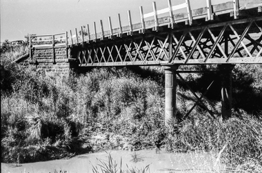
Film - Photograph by Herb Richmond. ca 1971, Devils Kitchen- Off the Scarsdale to Cape Clear Rd, Road Bridge over the Woady Yallok River
Ballarat History35mm B&W Kodak Plus X Pan Film.ballarat, ballaraat, devils, kitchen, bridge -
 Ballaarat Mechanics' Institute (BMI Ballarat)
Film - Photograph by Herb Richmond. ca 1971, Devils Kitchen- Off the Scarsdale to Cape Clear Rd, Road Bridge over the Woady Yallok River
Ballarat History35mm B&W Kodak Plus X Pan Film.ballarat, ballaraat, devils, kitchen, bridge -
 Ballaarat Mechanics' Institute (BMI Ballarat)
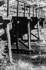
Film - Photograph by Herb Richmond. ca 1971, Hunts Bridge- On the Moorabool River, below Bungal Dam
Ballarat History35mm B&W Kodak Plus X Pan Film.ballarat, ballaraat, hunts, bridge, moorabool -
 Port Melbourne Historical & Preservation Society
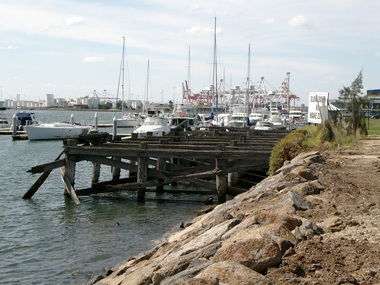
Photograph - Pier 35 marina, Lorimer Street, Fishermens Bend, Glen Stuart, 2002
Colour photo of Pier 35 marina on Lorimer St Fishermens Bend. Looking towards Coode Islandpiers and wharves, yarra river, pier 35 -
 Port Melbourne Historical & Preservation Society
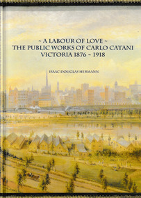
Book, Isaac Douglas Hermann, A Labour of Love The Public works of Carlo Catani Victoria 1876 - 1918, October 2021
The book covers all the Victorian Public Works projects of Carlo CATANI including the Catani Memorial Clock Tower & the Catani Gardens in St Kilda. Book, 'A Labour of love - the Public Works of Carlo Catani Victoria 1876 - 1918'. The front & back covers are from a 1905 painting by Laurence WILSON showing the southern approach to Melbourne and with Princes Bridge and the Yarra River.carlo catani, carlo catani memorial clock tower, catani gardens -
 Bendigo Historical Society Inc.
Postcard - GLADYS DEAN COLLECTION: POSTCARD, 1906 - 1908
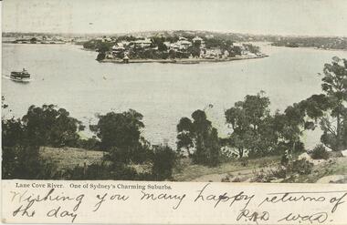
Coloured photographic postcard of Lane Cove River with 1.7cm white border on lower edge. The image depicts a bend of the Lane Cove River with many houses on the opposite shore at the apex of the bend and in the distance. A boat is on the far left, while trees and a person walking along a path are in the foreground. The words Lane Cove River. One of Sydney's Charming Suburbs are printed in black on the left hand side of the border. Handwritten across the border are the words Wishing you many happy returns of the day and a signature. On the reverse is a black and white image of an indigenous man lighting fire with a stick and the words Fire by friction printed across the image. Card is addressed to Miss Dean McKenzie St Golden Square. A one penny stamp is affixed and postmarked Bendigo.Symbol of artists palette with initials HB enclosedpostcard -
 Monbulk RSL Sub Branch
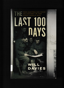
Book, Will Davies, Last one hundred days : the Australian road to victory in the First World War, 2018
... the river to Mont St Quentin, Péronne and on to the formidable ...In March 1918, with the fear of a one-million-man American army landing in France, the Germans attacked. In response, Australian soldiers were involved in a number of engagements, culminating in the Second Battle of Villers-Bretonneux and the saving of Amiens, and Paris, from German occupation. Then came General John Monash's first victory as the Commanding Officer of the newly formed Australian Corps at Hamel. This victory, and the tactics it tested, became crucial to the Allied victory after 8 August, the 'black day of the German Army'. On this day the major Allied counteroffensive began, with the AIF in the vanguard of the attack. The Australians, with the Canadians to the south and the British across the Somme to the north, drove the Germans back, first along the line of the Somme and then across the river to Mont St Quentin, Péronne and on to the formidable Hindenburg Line, before the last Australian infantry action at Montbrehain in early October. Fast-paced and tense, the story of The Last 100 Days is animated by the voices of Australian soldiers as they endured the war's closing stages with humour and stoicism; and as they fought a series of battles in which they played a pivotal role in securing Allied victory. Collapse summaryIndex, bibliography, notes, ill, p.340.non-fictionIn March 1918, with the fear of a one-million-man American army landing in France, the Germans attacked. In response, Australian soldiers were involved in a number of engagements, culminating in the Second Battle of Villers-Bretonneux and the saving of Amiens, and Paris, from German occupation. Then came General John Monash's first victory as the Commanding Officer of the newly formed Australian Corps at Hamel. This victory, and the tactics it tested, became crucial to the Allied victory after 8 August, the 'black day of the German Army'. On this day the major Allied counteroffensive began, with the AIF in the vanguard of the attack. The Australians, with the Canadians to the south and the British across the Somme to the north, drove the Germans back, first along the line of the Somme and then across the river to Mont St Quentin, Péronne and on to the formidable Hindenburg Line, before the last Australian infantry action at Montbrehain in early October. Fast-paced and tense, the story of The Last 100 Days is animated by the voices of Australian soldiers as they endured the war's closing stages with humour and stoicism; and as they fought a series of battles in which they played a pivotal role in securing Allied victory. Collapse summary world war 1914- 1918 - campaigns - western front, western front - australian participation - 1918 -
 Bendigo Historical Society Inc.
Document - MCCOLL, RANKIN AND STANISTREET COLLECTION: MAP OF MINE LEASES SYMONDS STREET, MCKENZIE ST WEST AREA BENDIGO, 2nd September, 1936
Blue waxed linen paper map. On top' Mining District of Bendigo' Parish of Sandhurst, County of Bendigo' Map shows lease 10135, area 32.1.19; lease 10371, area 30.0.23; lease 10179 area 41.3.4; lease 10370, area 49.0.1. Map indicates gully leading into and State Rivers and Water supply reservoir, water race; siphon, shaft, dam, residential area and some residential lots marked. Streets include Holly Street, MacKenzie Street West, Symonds Street, Aspinall Street, Emmett Street; Bendigo Creek marked at bottom of map. Scale 4 chains to one inch. Map is not dated.bendigo, mining, mccoll rankin & stanistreet -
 Bendigo Historical Society Inc.
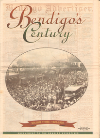
Newspaper - LONG GULLY HISTORY GROUP COLLECTION: BENDIGO'S CENTURY VOLUME THREE: 1920 - 1929
Newspaper supplement titled Bendigo's Century Volume Three: 1920 - 1929. Front page has a photo of The Duke and Duchess of York visit to Bendigo, 1927. Each year has heading of Who's Who, Weather, Sport and Business. First years are 1910 - 1919 titled The way we were. 1920 is titled Prince hailed. 1921 - City racks up a milestone. 1922 - Furore erupts. 1923 - Felons escape from city gaol. 1924 - Bid to finish RSL memorial. 1925 - Foul odour over sewerage plan. 1926 - Lest we forget Bendigo's fallen. 1927 - Royal Visit captures city. 1928 - Four shot in farm tragedy. 1929 - Billie's trip to remember.bendigo, history, long gully history group, the long gully history group - bendigo's century - volume three: 1920 - 1929, bendigo advertiser, duke and duchess of york, cr e m vains, r putnam, a j taylor, j h jackson, w crowley, sandhurst football club, george lansell, st peter's church, bendigo junior technical school, prince of wales, unity mine, mr w wilson, badak tin mining syndicate, mr t w ortonmr h scarborough, mr raleigh, general sir w r birdwood, the soldiers' memorial committee, bendigo city council, rsl memorial hall, captain g c wilson, lietenant r j parer, lieutenant j c mcintosh, cr j p carolin, h k morris, e a morris, turf tavern hotel, rev donald baker, all saints' pro--cathedral, keck's nursery, bendigo amalgamated goldfields, rising sun hotel, leanne mcdonnell, most rev john mccarthy, sir john quick, prime minister billy hughes, state rivers and water supply commission, diptheria, edna stevens, bendigo railway workshops, watson sustenance fund, sir joseph cook, dr lanza, bendigo amalgamated goldfields, bendigo benevolent asylum, miner's phthisis, bendigo gas company, electric light company, bendigo sewerage authority, commonwealth bank, cr curnow, the earl of stradbroke, dame nellie melba, princess theatre, lt-col g hurry, h sw lawson, countess of stradbroke, clunes woollen mills, girton college, mrs polglaise, mrs kennedy, gold discovery memorial, cr m g giudice, victorian co-operative freezing company, bendigo brick and tile company, mr lawson, soldiers' memorial, windermere hotel, toni riley pharmacy, bendigo gaol, mr a a dunstan mla, new red white and blue mine, claude de vere, walter osborne, sir john and lady quick, jonathan smalley, bendigo advertiser, st paul's bells, mr t cambridge, epsom public hall, bendigo school of mines, major lansell, mr h s w lawson, cr david andrew, colonel hurry, mr s bruce, bendigo sewerage authority, eppalock weir scheme, bendigo football league, r s l memorial, major g v lansell, lempriere, mr s m bruce, sandhurst hotel, market square, big hill tunnel, bendigo football league, bendigo united cricket club, south bendigo rex, sacred heart cathedral, hercules mine, gillies, aids & appliance shop, anne caudle centre, fizelle & mulqueen, south new moon mine, bendigo sewerage authority, mr a a kelley, epsom sewerage works, white hills botanical gardens, mr j sternberg mlc, bendigo book of remembrance, bendigo football league, senator general drake-brockman, captain dyett, school of mines, handschin and romus, hanro (aust.) bendigo knitting mills, charles handschin, farmers' union, andrew sunstan mla, country progressive party, john allan, captain g j c dyett, eahlehawk ufs dispensary, data fundamentals, the duke and duchess of york, the hercules mine, cr j a michelsen, lansell family, bendigo agricultural society, huntly shire council, bendigo creek trust, south african war memorial, cr j h curnow, st paul's church of england diamond jubilee, bendigo chamber of commerce, bendigo freezing works, bendigo pottery, bendigo trotting club, new red white and blue mine, the conservatory, cr e g batchelder, hercules mine, billie rigby, bendigo railway station, travellers' aid society, eppalock weir, the state rivers and water supply commission, bendigo railway workshops, frank grove, cr curnow, electric supply company, state electricity commission, australian aero club, bendigo preserving company, jardine, busbridge, feeman, mr h pearce, bfl, fred wood -
 Bendigo Historical Society Inc.
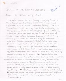
Document - ARTICLES FOR ROYAL HISTORICAL SOCIETY (BENDIGO BRANCH) NEWSLETTER TO MARCH 1973)
Articles for Royal Historical Society (Bendigo Branch) Newsletter - March 1973). 1. ''Bells in and around Bendigo - No. 4: A 'Schomberg Bell' '' - bell of Twin Rivers Presbyterian Camp, Eppalock with history from wreck of the 'Schomberg' (Warrnambool, 1855); mention of St. Andrews, Bendigo and Bendigo fire bell (pro tem). 2. Handwritten version of ''Bendigo City Coat of Arms'' (see Mosaic 6550 for description). 3. Typewritten version of 1. abovedocument -
 Bendigo Historical Society Inc.
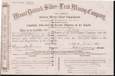
Document - KELLY AND ALLSOP COLLECTION: SHARE CERTIFICATES - MOUNT DEDDICK SILVER-LEAD MINING CO, 14/07/1898 to 09/02/1899
Document. KELLY & ALLSOP COLLECTION. Two share certificates issued by the Mount Deddick Silver-Lead Mining Company, No Liability, Snowy River, East Gippsland. Certificate No. 1851 for 20 fully paid up shares @ 1 Pound each issued on 14 July 1898 to M.Kelly. Certificate No. 2113 for 5 fully paid up shares @ 1 Pound each issued on 9 Feb.1899 to M.Kelly of Bendigo. Capital raised was 60,000 Pounds from 60,000 shares. Each certificate signed by the Manager (signature not readable). Registered office - 31 Queen St., Melbourne.Mount Deddick Silver-Lead Mining Co.business, stockbroker, kelly & allsop, kelly & allsop collection, share certificates, mount deddick silver-lead mining co., m.kelly. -
 Bendigo Historical Society Inc.
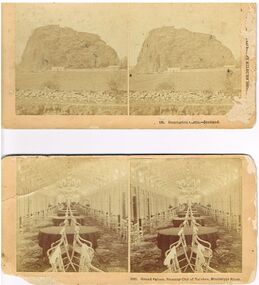
Photograph - 2 STEREOSCOPE PHOTO CARDS
2 x Stereoscope faded photos (circ. 1880's ?) on cream slightly damaged cards - Number 2532 , Grand Saloon , Steamer City of Natchez, Mississippi River showing tables , chairs and chandelier / Number 135. Dumbarton Castle - Scotland ,Photographed and published by Kilburn Brothers , Littleton N.H. / accompanying scrap paper states -'Antique photos -Stereoscope cards , Mr W. Ennis , 87 Harley St , Bendigo ,Kilburn Brothersphotograph, building, stereoscope photo cards /grand saloon , steamer city of natchez, mississippi river / dumbarton castle - scotland / kilburn brothers , littleton n.h /mr w. ennis , 87 harley st , bendigo -
 Man From Snowy River Museum operated by the Upper Murray Historical Society
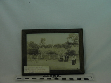
Framed Photo, The Bramley girls playing tennis at the Needles, Berringama, September 20th, 1902, Photograph taken 20th September, 1902
Photograph of Bramley family. Early residents of the Needles, Berringama, Victoria - 20th September, 1902Framed photograph of the Bramley girls playing tennis at the Needles, Berringama, Upper Murray. On back of frame - September 20th, 1902, at "The Needles" Berringama. Charles Bramley and sisters Minnie & Nellie - "The Bramley girls playing tennis."bramley, needles, berringama, tennis -
 Man From Snowy River Museum operated by the Upper Murray Historical Society
Stone Axe
Wasted Stone Axe Found at Lower Bringenbrong, New South Wales (On Murray Jarvis' Property) Cutting end relatively blunt (i.e. Not ground or polished). Large chip at top end -
Man From Snowy River Museum operated by the Upper Murray Historical Society
Newspapers, Corryong Courier 1953, 1953
Social & Commercial History of DistrictSocial & Commercial History of DistrictNavy Blue Bound Copies - Jan 1953 to Dec 1953Gold Letteringlocal newspaper -
Man From Snowy River Museum operated by the Upper Murray Historical Society
Newspapers, Corryong Courier 1954, 1954
Community & Commercial HistoryCommunity & Commercial HistoryNavy Blue Bound Copies - Jan 1954 to Dec 1954 Gold Letteringcorryong -
Man From Snowy River Museum operated by the Upper Murray Historical Society
Newspapers, Corryong Courier 1952, 1952
Social & Commercial History of DistrictSocial & Commercial History of DistrictNavy Blue Bound Copies - Jan 1952 to Dec 1952Gold Letteringlocal newspaper -
Man From Snowy River Museum operated by the Upper Murray Historical Society
Newspapers, Corryong Courier 1955, 1955
Social & Commercial HistorySocial & Commercial HistoryNavy Blue Bound Copies - Jan 1955 to Dec 1955Gold Letteringlocal newspaper -
Man From Snowy River Museum operated by the Upper Murray Historical Society
Newspapers, Corryong Courier 1956, 1956
Social & Commercial History of DistrictSocial & Commercial History of DistrictNavy Blue Bound Copies - Jan 1956 to Dec 1956Gold Letteringlocal newspaper -
Man From Snowy River Museum operated by the Upper Murray Historical Society
Newspapers, Corryong Courier 1957, 1956
Social & Commercial History of DistrictSocial & Commercial History of DistrictNavy Blue Bound Copies - Jan 1957 to Dec 1957Gold Letteringlocal newspaper -
Man From Snowy River Museum operated by the Upper Murray Historical Society
Newspapers, Corryong Courier 1958, 1958
Social & Commercial History of DistrictSocial & Commercial History of DistrictNavy Blue Bound Copies - Jan 1958 to Dec 1958Gold Letteringlocal newspaper -
Man From Snowy River Museum operated by the Upper Murray Historical Society
Newspapers, Corryong Courier 1959, 1959
Social & Commercial History of DistrictSocial & Commercial History of DistrictNavy Blue Bound Copies - Jan 1959 to Dec 1959Gold Letteringlocal newspaper -
Man From Snowy River Museum operated by the Upper Murray Historical Society
Newspapers, Corryong Courier 1960, 1960
Social & Commercial History of DistrictSocial & Commercial History of DistrictNavy Blue Bound Copies - Jan 1960 to Dec 1960Gold Letteringlocal newspaper -
Man From Snowy River Museum operated by the Upper Murray Historical Society
Newspapers, Corryong Courier 1961, 1961
Social & Commercial History of DistrictSocial & Commercial History of DistrictNavy Blue Bound Copies - Jan 1961 to Dec 1961Gold Letteringlocal newspaper -
Man From Snowy River Museum operated by the Upper Murray Historical Society
Newspapers, Corryong Courier 1962, 1962
Social & Community History of DistrictSocial & Community History of Districtlocal newspaper -
Man From Snowy River Museum operated by the Upper Murray Historical Society
Newspapers, Corryong Courier 1963, 1963
Social & Commercial History of DistrictSocial & Commercial History of DistrictNavy Blue Bound Copies - Jan 1963 to Dec 1963Gold Letteringlocal newspaper -
Man From Snowy River Museum operated by the Upper Murray Historical Society
Newspapers, Corryong Courier 1964, 1964
Social & Commercial History of DistrictSocial & Commercial History of DistrictNavy Blue Bound Copies - Jan 1964Gold Letteringlocal newspaper