Showing 3180 items
matching road map
-
 Eltham District Historical Society Inc
Negative - Photograph, J.A. McDonald, Sherbourne Road, Montmorency, c. July 1962
View looking west across Sherbourne Road to intersection of Rattray Road from present-day forecourt entrance to 7-Eleven Eltham service station The BP Service Station is now an Ampol Service Station (2022) Google Street View Apr.. 2022 https://goo.gl/maps/LM4APKCwj1ohBDPv5Record of various Shire of Eltham infrastructure works undertaken during the period of 1952-1962 involving bridge and road reconstruction projects, sometimes with Eltham Shire Council Project Reference numbers quoted. It was during this period that a number of significant improvements were made to roads and new bridges constructed within the shire that remain in place as of present day (2022). In many situations, the photos provide a tangible visible record of infrastructure that existed throughout the early days of the Shire. The album was put together by or under the direction of the Shire Engineer, J.A. McDonald.1962-07, ampol service station, bp service station, montmorency, rattray road, service station, sherbourne road, infrastructure, reconstruction works, road construction, shire of eltham -
 Eltham District Historical Society Inc
Slide - Photograph, Eltham Shire Council, Plan of Subdivision, Crown Allotment 8, Section 8A, Parish of Nillumbik,County of Evelyn, 1969
35mm colour positive transparency blue Agfacolour Service plastic mountC1, Pain, Sibbel and Carter, Research-Warrandyte Road, North Warrandyte, 4 August 1969carter, infrastructure, map, north warrandyte, pain, parish of nillumbik, plan of subdivision, planning, research-warrandyte road, sibbel, subdivison lots -
 Eltham District Historical Society Inc
Slide - Photograph, Eltham Shire Council, Plan of Subdivision of Part of Crown Allotment 4, Section 2 at Kangaroo Ground, Parish of Nillumbik, County of Evelyn, 1969
35mm colour positive transparency blue Agfacolour Service plastic mountC6, Kimse, Kangaroo Ground-St Andrews Road, 4 August 1969infrastructure, kangaroo ground, kangaroo ground-st andrews rd, kimse, map, plan of subdivision, planning, subdivison lots -
 Eltham District Historical Society Inc
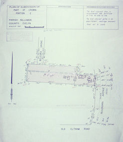
Slide - Photograph, Eltham Shire Council, Plan of Subdivision, Part of Crown Portion 3, Parish of Nillumbik, County of Bourke, 1969
... melbourne Infrastructure Map Montmorency planning Rattray Road ...35mm colour positive transparency blue Agfacolour Service plastic mountC5C, Delbridge, 4 lots, Rattray Road, 4 August 1969infrastructure, map, montmorency, planning, rattray road, subdivison lots, reichelt avenue -
 Eltham District Historical Society Inc
Slide - Photograph, Eltham Shire Council, Proposed plan of subdivision, Mrs Du Lee, Warrandyte, 1969
35mm colour positive transparency blue Agfacolour Service plastic mountB2, Du Lee Subdivision, Research-Warrandyte Road, 4 August 1969infrastructure, map, planning, subdivison lots, du lee, glynns road, research-warrandyte road -
 Eltham District Historical Society Inc
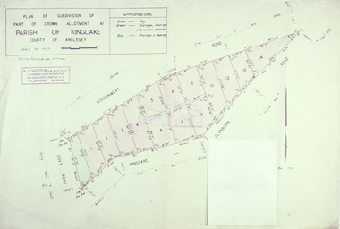
Slide - Photograph, Eltham Shire Council, Plan of subdivision of Part of Crown Allotment 41, Parish of Kinglake, County of Anglesey, 1969
35mm colour positive transparency blue Agfacolour Service plastic mountC8, N. Johnson, Kinglake-Glenburn Road, 4 August 1969infrastructure, map, planning, subdivison lots, n. johnson, kinglake-glenburn road, kinglake -
 Eltham District Historical Society Inc
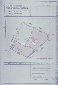
Slide - Photograph, Eltham Shire Council, Plan of subdivision of Part of Crown Portion 2, Parish of Nillumbik, County of Evelyn, 1969
35mm colour positive transparency blue Agfacolour Service plastic mountC4, Warton, Panorama and Beleura, 4 August 1969infrastructure, map, planning, subdivison lots, beleura grove, old eltham road -
 Eltham District Historical Society Inc
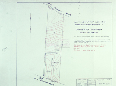
Slide - Photograph, Eltham Shire Council, Tentative Plan of Subdivision, Part of Crown Portion 2, Parish of Nillumbik, County of Evelyn, 1969
35mm colour positive transparency blue Agfacolour Service plastic mountB4, Fisher subdivision, Old Eltham Road and Main Road, 4 August 1969infrastructure, map, planning, subdivison lots, main road, old eltham road -
 Eltham District Historical Society Inc
Slide - Photograph, Eltham Shire Council, Tentative Plan of Subdivision, Part of Crown Allotment 20A and Part 20B, Parish of Nillumbik, County of Evelyn, 1969
35mm colour positive transparency blue Agfacolour Service plastic mountE2, N899, Young subdivision, Kangaroo Ground-Warrandyte Road, North Warrandyte, 4 August 1969infrastructure, map, planning, subdivison lots, kangaroo ground-warrandyte road, north warrandyte -
 Eltham District Historical Society Inc
Slide - Photograph, Eltham Shire Council, Proposed extension of Railway Road, Briar Hill, 1969
35mm colour positive transparency blue Agfacolour Service plastic mountA4, Railway Road intersection, 4 August 1969infrastructure, map, planning, subdivison lots, railway road, carter street bridge, para road, para road bridge, briar hill -
 Eltham District Historical Society Inc
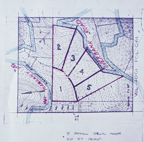
Slide - Photograph, Eltham Shire Council, Proposed subdivision of five approximately equal areas of 5 acres, Vol. 4061, Fol. 061, Overbank Road, North Warrandyte, 1969
35mm colour positive transparency blue Agfacolour Service plastic mountD4, 55341, Peck subdivision, Mount Pleasant Road, 4 August 1969infrastructure, map, planning, subdivison lots, overbank road, mount pleasant road, north warrandyte -
 Eltham District Historical Society Inc
Slide - Photograph, Eltham Shire Council, Plan of Subdivision, Part of Crown Allotments 5 & 6, Section 10, Parish of Nillumbik, County of Evelyn (Foster Road, Eltham East), 1969
35mm colour positive transparency blue Agfacolour Service plastic mountC5(a) DU (Vic) D/L Foster Road, Eltham East, 4 August 1969infrastructure, map, planning, subdivison lots, abersham court, ancona close, eltham east, floriston grove, foster road, frank street, gladwyn court -
 Eltham District Historical Society Inc
Slide - Photograph, Eltham Shire Council, Plan of Subdivision of Part of Crown Portion 2, Parish of Nillumbik, County of Evelyn, 1969
35mm colour positive transparency blue Agfacolour Service plastic mountC2, Grant of subdivision, Para and Glenauburn, 4 August 1969infrastructure, map, planning, subdivison lots, glenauburn road, para road -
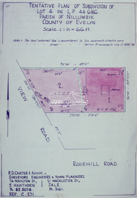 Eltham District Historical Society Inc
Slide - Photograph, Eltham Shire Council, Tentative Plan of Subdivision of Part of Lot 4 on L.P. 44 686, Parish of Nillumbik, County of Evelyn, 1969
35mm colour positive transparency blue Agfacolour Service plastic mountB3 Robinson prelim subdivision, View Road, 4 August 1969infrastructure, map, planning, subdivison lots, view road, rosehill road, lower plenty -
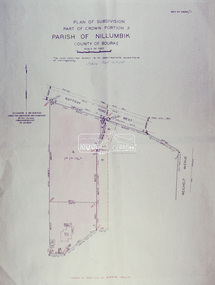 Eltham District Historical Society Inc
Slide - Photograph, Eltham Shire Council, Plan of Subdivision, Part of Crown Portion 3, Parish of Nillumbik, County of Bourke, 1969
35mm colour positive transparency blue Agfacolour Service plastic mountB3 Robinson prelim subdivision, View Road, 4 August 1969infrastructure, map, planning, subdivison lots, rattray road -
 Glen Eira Historical Society
Article - Trinity Congregational Church, Glen Huntly
Handwritten undated notes (refer History of Primitive Methodism in Victoria and Tasmania – Rev. M Clarke). Article includes style of church building, history of building and interior decoration. Also includes history of some monetary donations, purchasing of land and church opening , small handdrawn map showing where church was before removal to current site. Reprinted articles from The Victorian Independant dated January 1910 and November 1909 on the opening of the Glen Huntly venture and the Revs who participated, and then the beginning of some committees, & Fellowship groups. Also mentions the appointment of Ivan Stebbins for six months.trinity congregational church, glen huntly, tennis, grange road, mercy g.g., bevan dr., primitive methodist church, dovan a. p. rev., holley j. j. rev., eastern road., freeman w, jones j. w. rev., south melbourne, griffith a. j. rev., devenish a. s. rev., lord. t, gosman dr, jones alfred., bryant. s, stebbins ivan, orr mr., billinghurst mr, copper mr, tregaskis mr., davidson mr., congregational hall, halls, wharington mrs., pavell g., rosstown, holden mr., bishop mr., sunday schools, white a. f., cockfield mr., orr mrs., billinghurst mrs., davidson mrs., o’ donnell miss, watkins miss., billinghurst miss., davidson miss., griffith mr., newing mr. -
Glen Eira Historical Society
Map - Kilvington Baptist Girls Grammar School
... Schools Ormond Lillimur Road Walsh Street Ormond Girls School ...One hard copy and one photocopy of Kilvington Baptist Girls Grammar School Planning brief dated October 1982. The brief details the current needs of the school and has been written to spell out a forward plan for development in the foreseeable future. It includes data on the current forecast enrolments at primary and secondary levels as well as the current and future use and development of the buildings and their use. Author of the brief is unknown.kilvington baptist girls grammar school, schools, ormond, lillimur road, walsh street, ormond girls school, kilvington girls grammar school, leila road, katandra road, ulupna road -
Glen Eira Historical Society
Document - Murrumbeena State School No. 3449
Submission to Caulfield Council for the construction of a Community Education Facility/Multi- Purpose Room for Murrumbeena State School Prepared for submission April, 1981, Rationale for costing of Community Education/ Multi- Purpose facility. Contains Street maps of area, Plans for proposed new structuremurrumbeena state school, hobart road murrumbeena, school, caulfield city council, school council, howard and munro architects., community education, facility, site plans, murrumbeena primary school council, education department. -
Glen Eira Historical Society
Book - Murrumbeena State School No. 3449
This file contains a booklet celebrating Murrumbeena Primary School 75th Anniversary written and compiled by Brian Burgess. This book includes a written history with accompanying photos, maps and official papers, as well as lists of Principals, teachers and other staff, as well as personal recollections and a list of notable acknowledgements.murrumbeena primary school, william murray ross, oakleigh, caulfield times, celebrations, rosstown, certificate of title, brian burgess, carnegie, neerim road, mary scanlon (principal), hobart road., connie mc millan, caulfield, mary grant wilson, bert hunkler, malvern and caulfield gazette, mr. r. mcllroy, right reverend phillip newell – bishop of tasmania, robert spence, judith odger – evans, dora holmes, r. p. mclellan – director of primary education, dianne mierze jewski (nee greaves), head teachers/ principals, staff list -
Glen Eira Historical Society
Book - Murrumbeena State School No. 3449
This file contains 1 x 90th Anniversary booklet on Murrumbeena Primary School 1917 – 2007. The booklet contains copies of official papers, maps, building works and maintenance of significance, the certificate of Title, recollections of individual students and staff, notable newspaper articles, photos of building, staff and pupils, as well as the surrounding area, lists of head teachers/ principals, teachers and other staff and Murrumbeena Primary School logos. In addition to the 90th Anniversary booklet there is also a pamphlet in the form of a program to celebrate the events listed on 25/08/2007 and diagram of buildingsmurrumbeena primary school, carnegie, neerim road, celebrations, hobart road, connie mcmillan, william murray ross, oakleigh and caulfield times, caulfield, certificate of title, mr r. mcllroy, rosstown, malvern and caulfield gazette, john hancorne, right reverend phillip newell – bishop of tasmania, robert spence, judith odgers – evans, dora holmes, dianne mierzejewski (dianne greaves), staff photos, staff list, head teachers/ principals, murrumbeena primary school 50th, anniversary 1931 – 1981., class photos. -
Glen Eira Historical Society
Document - Bakewell Family
There are 3 items about this family of early European settlers in Victoria: 1/A photocopy of an extract “Early Pioneer Families of Victoria and Riverina” – Henderson Page 441-442 The Bakewell Family of Burnewang and Tooradin”. It includes a photo of John Bakewell (1807-1888). It contains two pages and describes Bakewell’s property expansion. 2/An original copy of handwritten, unsigned undated research notes on John Bakewell property holdings taken from St Kilda Rate Book (1859-1873). It describes the land allotment. 3/A typed, unsigned, undated extract from 'The Howitts in Australia by Mary Howitt' - Mary Howitt, Vic Hist Mag 1913 Vol 3 No. 1. Reference – Memoirs of a Stockman, Harry Peck, 1853 Map, Foot Plot CCXLVI at Kooyong & Glen Eira Road. It provides a brief outline of the lives of brothers Robert and John Bakewell.the bakewell family, early pioneer families, henderson, bakewell john, port phillip, burnewang, bakewell robert, howitt godfrey dr, lord goderich, tooradin, phoebe, friends' school ackworth, yorkshire, nottingham, shaw john wyberg, plenty river, businesses, goldsbrough richard, goldsbrough mort and company ltd., glaziers, squatters, burnewang, mantons, tooradin, red bluff, torbinurruck, great swamp, brenanah, westernport, numerella, snowy river, orbost, green hills b, caramut, lyall william, mickle john, buckland john, notts, england, balderton, weddings, jane emily, howitt emanuel, farnsfield, lever mary, howitt thomas, heanor, derbyshire, howitt godfrey, scales john, exeter college oxford, downing college cambridge, guerard von, wayne john, south warnborough manor, harrison robert, lord john, jamaica, mary alice, dr. miller, miller john francis compton, emmie joan, mary emily, clifton hotel welbeck street, phoebe alice, anne edith, british museum, land values, settlements, st. kilda, elsternwick, inkerman street, st. kilda east, kew, memoirs of a stockman, harry peck -
 Glen Eira Historical Society
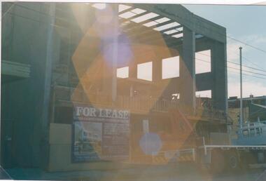
Photograph - Hawthorn Road, 342, Caulfield
Two items about this address: 1/Two colour photos of a commercial building under construction on Hawthorn Road in September 1987. Building is south of Glenhuntly Road on western side And was being built for Caulfield City Council. 2/Print of comment entered 03/03/2019 on Victorian Collections website for this file from reader Angus giving street number as '342'. Google map photo print done 04/04/2019 confirms this.hawthorn road, caulfield, caulfield city council, commercial buildings, council buildings -
Glen Eira Historical Society
Book - Uniting Church in Australia – Elsternwick/Caulfield South Parish
Two items about this subject: /A book written by Gwenda Mann (donator) about the coming together of Uniting Church Australia Elsternwick/Caulfield South Parish. There were previously nine churches before the union. The book includes short histories about all of the churches, their congregation ministers and some memories from the church members. There are twenty black and white photographs, three illustrations and a map of the churches in the book. Included at p32 is 1 1/2 pages of memories from Glen Eira Historical Society member Norma Ward. 2/The second document is an order of service for the Unity Church Australia on 09/08/1998. There are two illustrations in the pamphlett.balaclava methodist, caulfield – kooyong road methodist, caulfield – hawthorn road methodist, caulfield – bambra road methodist, caulfield – bundeera road methodist, caulfield west – ontario street methodist, elsternwick – orrong road methodist, elsternwick congregational – ex union church, elsternwick – st. john’s presbyterian, elsternwick methodist, camden primitive methodist, ontario street methodist, bundeera road methodist, bambra road methodist, kooyong road methodist, caulfield presbyterian church, caulfield union church, mann gwenda, gray gordon, wright joan rev., parish, church, ward norma -
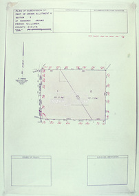
 Eltham District Historical Society Inc
Document - Photocopy, Survey Fleld Notes of Part of Crown Portion 13, Section 4 at Eltham, Parish of Nillumbik, County of Evelyn, 1902-1903
Main Road, Henry Street to Diamond Street; Silver Street to Bible Street Application No. 0337771902, 1903, arthur street, bible street, bird street, diamond creek (creek), diamond street, eltham, eltham railway station, henry street, main road, silver street, survey plan, vine street, application 33777, map -
Glen Eira Historical Society
Ephemera - Riddell Family
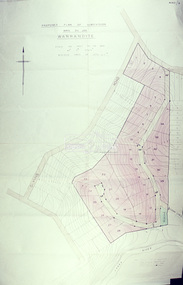
2 photocopied maps, one dated 1884 of the Gardenvale Estate and then named Riddell Estate, taken from the State Library of Victoria website. Research note by Claire Barton dated 16/04/2013 concerning Carre Street subdivision. Article from ‘Glen Eira Leader’ dated 13/11/2002 with advertisement for sale of an apartment in Renown Apartments.gardenvale estate, glen huntly road, elsternwick, \fraser and co., mcmillan street, brighton road, orrong road, rowan street, archibald street, hamilton street, downshire road, shoobra road, riddell mrs, elsternwick railway station, stanley street, gisborne street, carre street, muntz and muntz, ‘cave carre’, brighton railway, subdivisions, housenames -
Glen Eira Historical Society
Map - Orienteering
This file contains one item. A map/plan of the Bentleigh East Running Roulette for the Monday series on 21/03/2011.bayside kangaroos orienteering, bentleigh east, sedunary vic, leicester paul, sheahan jenny, clubs, sheahan john, tamblyn greg, centre road bentleigh, tucker road bentleigh, south road moorabbin, associations, nepean highway, bentleigh rsl club, orienteering, sports, recreations -
Glen Eira Historical Society
Plan - Chinese Community in Glen Eira
Three pages on Chinese in Glen Eira. One hand drawn map of residents living in surrounds of Murton Hall, Chinese Church from SANDS AND MCDOUGALLS 1914 edition by Claire Barton. Printed page from FILE 1234 on Thomson Memorial Church. Hand written Chinese gardeners and related associations from SANDS AND MCDOUGALLS. Page from PROV Book 2013 with a Victorian Garden License.ruby street, reeves william, murton hall, chinese church, malva street, beattie rev. j., ocean street, gould mrs. s., belmont, house names, munn harry, maud street, ormond hall, taylor herbert, raymond rev. h., north road -
Glen Eira Historical Society
Plan - Ristori
Real Estate leaflet for the subdivision sale of the Ristori Estate & Residence on 31/05/1919 by Yeo, Crosthwaite & Co. A map of the 24 subdivisions available plus a locality plan are included along with details of separate sale on 04/06/1919 of the weatherboard buildings, rooms, stables & glass house.house names, 'ristori', land sales, sewerage, glen eira road, brick houses, land subdivision, orrong road, glasshouses, yeo crosthwaite & co melbourne, ripponlea, stables, ristori estate, auctions, drainage, liscard street, st. georges road, balaclava road, glen huntly road, glenhuntly road, elsternwick station, hotham street, weatherboard buildings, elsternwick -
 Glen Eira Historical Society
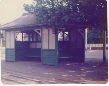
Article - Tram Shelter, Dandenong Road
National Trust of Australia, Victoria, report giving details of tram shelters on the tramways routes of Melbourne; history of cable car system and reasons for tramways amalgamations, includes architectural plan, map and photocopies of two photographs before restoration 1994. Includes bibliography. Two coloured photographs of tram shelter Dandenong Road opposite Hawthorn Road taken in 1978. Detailed history from the Trust News 2000 on history of Melbourne Tram Shelters, various architectural design features, where erected and who design by.dandenong road, hawthorn road, north caulfield, glen eira, flannagan l.s., prahran and malvern tramways trust, street furniture, tram shelters, edwardian style, architectural features, glenhuntly road, caulfield, orrong road, balaclava road, watson stephen, storey rohan, ward andrew -
Glen Eira Historical Society
Map - Brighton Cemetery, North Road, Caulfield South
... Cemeteries Grave yards Map Brighton Cemetery, North Road, Caulfield ...Photocopy of a typed letter from the National Trust (Victoria), dated 23/10/1997, to Brighton Cemetery Trust, notifying of the classification o the cemetery in the National Trust Register. An undated photocopy of a map and plan of Brighton Cemetery.brighton cemetery, north road, caulfield south, burke chris, brighton cemetery trust, sheffield road, hawthorn road, cemeteries, grave yards