Showing 10763 items
matching sites
-
 Kiewa Valley Historical Society
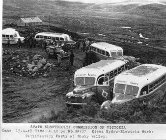
Photograph - Parlimentary Party visiting Rocky Valley Dam site, 15-4-1948
This photograph was taken during construction of the Rocky Valley Dam and wall. Work was commenced in early 1947 but had to be suspended during winter and then resumed in October. Work continued in 1948 with the establishment of work facilities and, at the dam site, the river was diverted through a temporary pipeline. Rocky Valley and associated spillway and outlet works were completed in 1959.A pictorial record of the construction of the rock and earth filled dam wall at Rocky Valley. Shows the extent of the project undertaken and the level of importance of the project as indicated by the large representation at the parliamentary party visit on 15/4/48.Photocopy of black and white photograph of parliamentary party visiting Rocky Valley Dam site 15/04/1948Typed on the bottom of photocopy - State Electricity Commission of Victoria. Date: 15-4-48 Time: 4.30pm No: K4397. Kiewa Hydro-Electric works. Parlimentary Party at Rocky Valleyrocky valley dam, parliamentary party, secv -
 Vision Australia
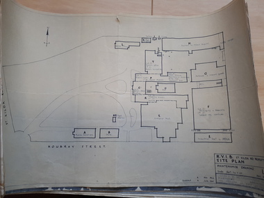
Plan - Image, RVIB Maintenance drawing, April 1963 - November 1966
A series of maintenance drawings were made or copied by an architectural firm. These plans include: 1 - St Kilda Road Property - a site map of the buildings and grounds with the names of the various areas added. 2 - St Kilda Road Central Building (copied from a RAAF drawing) showing rooms on the ground floor. 3 - St Kilda Road Central Building (copied from a RAAF drawing) showing rooms on the first floor. 4 - St Kilda Road Central Building roof plan. 5 - St Kilda Road Factories showing the layout on the ground floor. 6 - St Kilda Road Factories showing the layout on the first floor. 7 - St Kilda Road building showing all three floors of the building rented out to Alfred Hospital. 8 - St Kilda Road caretaker, factory, fundraising and rehabilitation training buildings. 9 - Raleigh Street, Prahran hostel layout for both girls and boys.9 pages of plans of buildings on St Kilda road siteVarious - see individual plansmyer house, royal victorian institute for the blind, plans, raleigh street hostel, alfred hospital -
 Whitehorse Historical Society Inc.
Document, Course land ownership documents, 1965
Plan and accompanying land transactions and survey documents.Plan and accompanying land transactions and survey documents and progression of ownership of property acquired by William Course in Nunawading from 1858 to 1883, including the Parkmore State School site.Plan and accompanying land transactions and survey documents.course family, course william, land titles, parkmore state school no 4881 -
Whitehorse Historical Society Inc.
Article, Station sells for $10.7m, 2016
BP Blackburn property on Whitehorse Road, Blackburn.BP Blackburn property on Whitehorse Road, Blackburn sold for 10.7 m. which equates to $2547 per square metre. The Lexus of Blackburn site sold for $18m in 2015.BP Blackburn property on Whitehorse Road, Blackburn.service stations, whitehorse road, blackburn, lexus of blackburn -
 Lakes Entrance Historical Society
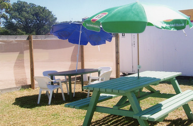
Photograph - Beer Garden Club Hotel Site, Lakes Post Newspaper, 2001c
Owners had to provide service of alcohol in order to retain their licence. Locals referred to site as 'The Porta Pub'Colour photograph of tables and umbrellas for beer garden, next to portable building on site of what was the Club Hotel, after the fire had destroyed the original building. Lakes Entrance Victoriarecreation, disasters, business -
 Kew Historical Society Inc
Document, Pru Sanderson Design Pty Ltd, History and Description of 'Glencara', Sackville Street, 1984-1988
History, description, site plan and house plan of 'Glencara' at 59 Sackville Street, Kew.2-page document with site plan and internal layout of Glencara (b.1893,) 59 Sackville Street, Kew. The text in the document is identical to that in Pru Sanderson's Kew Conservation Study (1988).glencara -- sackville street -- kew (vic), houses -- sackville street -- kew -
 Ringwood and District Historical Society
Book, Archaeological Assessment of Historical Orchard Site and Coach & Horses Hotel Site
Archaeological Assessment of Historical Orchard Site and Coach & Horses Hotel Site -
 St Kilda Historical Society
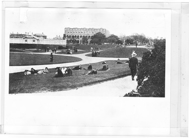
Photograph, West Beach and Catani Gardens, c. 1915-1916
c1915, site of the old bathing ship black and white photograph, unmountedMelbourne Suburbs St Kilda View of West Beach, improvement site of the Old Ship, St Kilda By the Sea Annual, p.63, season 1915-16, National Library of Australia -
 The Beechworth Burke Museum
Photograph, 2000
Woolshed is a small area about five kilometres north west of Beechworth, and almost about 225km north east of Melbourne. When gold was discovered at the nearby Spring Creek in February 1852, Woolshed was one of three settlements set up to house miners and their families. At its peak in 1857, Woolshed was also populated by 29 storekeepers and 14 hotels, as well as the Woolshed State School, which stood near where this photograph was taken. The school often played host to public meetings, as well as a public dance in 1897. The school was subject to some controversy in 1874 when one parent complained about the head of the school in the local newspaper, the Owens and Murray Advertiser, and at least three letters to the editor were exchanged between the two. According to the parent, C. O'Donoghue was not providing enough amusement for the children and was disrespectful to parents and staff. When the State Governor, Sir Reginald Talbot, visited Beechworth in 1906, the school organised a celebratory welcome. The Woolshed State School was ultimately closed in 1922 as miners had exhausted the Spring Creek gold supply and were moving elsewhere. This photograph, taken in about 2000, shows the trees that grew on or near the site of the original school. The Woolshed State School Honour Roll, with a list of the men from the school who served in the First World War, also still exists. It is stored in the Beechworth RSL as of 2015.This photograph is significant for its connection to an important site in Beechworth's gold mining history. Woolshed served a significant community of miners, with a population of at least 138 according to the 1911 census, with families that needed the school site to ensure their children's education. The image is also useful for prompting discussion about how Beechworth has changed over time, with the photograph taken 78 years after the school closed down.A colour rectangular photograph printed on glossy photographic paper.Woolshed State. / School site / 2000 / - remnant trees / / cobeechworth, burke museum, school, education, trees, nature, state school, woolshed, gold mining, teachers, over time, owens and murray advertiser, public meetings, public dance, c. o'donoghue, spring creek, state governor, sir reginald talbot, miners, honour roll, world war 1 -
 Whitehorse Historical Society Inc.
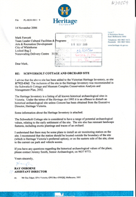
Letter - Correspondence, Schwerkolt Cottage and Orchard site, 14/11/2006 12:00:00 AM
Letter from Heritage Victoria to Mark Fawcett, City of Whitehorse, 16 November 2006 .Letter from Heritage Victoria to Mark Fawcett, City of Whitehorse, 16 November 2006 . Re. inclusion of Schwerkolt Cottage and orchard site in the Victorian Heritage Inventory, with plan and aerial photographLetter from Heritage Victoria to Mark Fawcett, City of Whitehorse, 16 November 2006 . fawcett, mark, schwerkolt cottage & museum complex, historic sites -
 Sunbury Family History and Heritage Society Inc.
Photograph, The Royal Hotel, c1939
The two storey building is the Royal Hotel which is sited on the corner of Brook and Evans Streets in Sunbury's main shopping strip.The photograph was taken sometime in 1939 after it was totally rebuilt. A fire had damaged the old single storey structure, which was built on the same site c1860 shortly after Sunbury had a rail service. The building still operates today on the same site.The Royal Hotel is one of four hotels that were built in Evans Street Sunbury between Brook and Station Streets ion the 1860s shortly after the rail service arrived in the town. They were They were the Railway Hotel (Olive Tree), White Horse Hotel, Royal Hotel and the Rupertswood Hotel, opposite the Royal Hotel. A non-digital black and white photograph with a cream border of a two storey brick hotel building with light concrete trimming around the windows and entrances sited on a corner. A large black sedan car is parked near the corner. royal hotel, hotels -
 Hume City Civic Collection
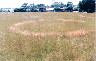
Photograph, early 1990's
This is one of a series of Aboriginal rings which are found in the Sunbury area. The former Shire of Bulla published a detailed study of the Aboriginal Ring sites in the early 1990's.A coloured photograph of a sacred site featuring an Aboriginal ring within the Sherwood Housing Estate. There is a cleared grassed area with a distinctive ring in the foreground with the housing estate in the background.sherwood estate, aboriginal ring sites, george evans collection -
Whitehorse Historical Society Inc.
Article, Shopping centre facelift, 1983
A new building for the south-west corner of Whitehorse Road and Station Street Mitcham.A new building for the south-west corner of Whitehorse Road and Station Street Mitcham. The upper floor offices are to be occupied by the legal firm, Mulcahy, Mendelson and Round. The site was originally that of the Hill Hotel.A new building for the south-west corner of Whitehorse Road and Station Street Mitcham. mitcham shopping centre, whitehorse road, mitcham, station street, mitcham, mendelson, roger, mulcahy, mendelson and round, hill hotel, mitcham -
 Bendigo Historical Society Inc.
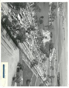
Photograph - ELMORE FIELD DAYS 1970
Elmore Field Days were first held in 1964.Black and white aerial photograph of Elmore Field Days site. Lines of exhibitors and vehicles on site. Anabranch of Campaspe River alongside site. On back of photo :' Robert Wallace Studios, 8 Ruth Street, Golden Square' Elmore Field Days site has been moved to purpose built site nearbye. The site pictured is now a camping reserve.event, agriculture, elmore field days -
 Tatura Irrigation & Wartime Camps Museum
Photograph, Casey Street, Tatura
Shows site of old Sacred Heart School, corner of Frances and Casey Streets, Tatura. Shows back of St Mary's and Convent.Colour photograph showing site of old Sacred Heart School, Casey Streets, Tatura. Shows back of St Mary's and Convent. Photograph stuck onto piece of white cardboard. hogan street tatura, casey street tatura, sacred heart convent tatura, sacred heart college tatura -
Whitehorse Historical Society Inc.
Drawing - Illustration, Annie Dines, 1992
Sketch from a photograph of Annie Dines house.Sketch from a photograph of Annie Dines house built 1889 and demolished 1949, site of Box Hill Town Hall - sketched by N. Jamieson. Also photocopy of the original photo.Sketch from a photograph of Annie Dines house. whitehorse road, box hill, dines, annie, box hill town hall -
Whitehorse Historical Society Inc.
Article, Plaques unveiled, 1970
Commemorative plaques were unveiled at Antonio Park.Commemorative plaques were unveiled at Antonio Park, dedicated to the Antonio Family who settled on the site and later bequeathed the property to the Nunawading City Council (Photo of niece of the Antonio brothers)Commemorative plaques were unveiled at Antonio Park.antonio park mitcham, dobie, dorothy, rotary club of nunawading, sheppard, harry, antonio family, city of nunawading -
 City of Moorabbin Historical Society (Operating the Box Cottage Museum)
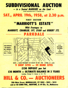
Flyer - Marriott's Estate, Parkdale, 1958
After WWII there was a decline in the market gardens in the City of Moorabbin, as the value of the land was more profitable than the crops.Example of the progress of the Municipality of MoorabbinPhotocopy of advertising flyer for auction of real estate sales - plan of building blocks for saleMarriott's Estate, Parkdale - Auction 19 April 1958 - 39 home sites - 9 shop sitesmarriott street, chandler st, ivy st, robert st, parkdale, real estate, auction -
 Bendigo Historical Society Inc.
Photograph - CASTLEMAINE GAS COMPANY COLLECTION: BUILDING SITE
Gas and Fuel building site - 2 workers on site - Date and location Unknownbuildings, commercial, gas and fuel -
 Bendigo Historical Society Inc.
Photograph - CASTLEMAINE GAS COMPANY COLLECTION: BUILDING SITE
Gas and Fuel Building site - 2 Workers on site - Date and Location UnknownFujicolorbuildings, commercial, gas and fuel -
Whitehorse Historical Society Inc.
Map, Applied for the Roman Catholic Church, 1848
Photocopy of manuscript map inscribed 'Reserve 40 Parish of Nunawading'.Photocopy of manuscript map inscribed 'Reserve 40 Parish of Nunawading'. Streets not named. Note on verso: Site reserved for Roman Catholic Church in Nunawading c1848 (Cr Riversdale and Warrigal Roads)Photocopy of manuscript map inscribed 'Reserve 40 Parish of Nunawading'. churches, catholic church, riversdale road, surrey hills, warrigal road, surrey hills -
 Slovenian Association Melbourne
Photo, Lojze Markic: building site
At the building site -
 Federation University Historical Collection
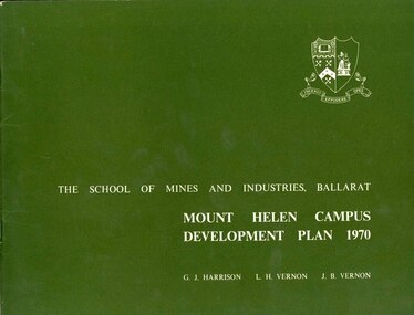
Book, Mount Helen campus Development Plan 1970, 1970
Green and white soft covered booklet of 48 pages. SMB Crest is on the front cover. The content include the Mt Helen site, site planning, student residences, sporting facilities, roads and parking, pedestrian circulation, engineering services, and landscaping. Illustrations include: Plan of Mt Helen Site (July 1969, existing buildings, Functional relationship, Roads and Parking, Pedestrian Circulation, engineering Services, Landscaping, Development Plan, Plan of Academic area, Library and union Courtyards, Birds Eye View of Academic Area from north-west, etc. the master plan projects student numbers.non-fictionuniversity of ballarat, ballarat institute of advanced education, mount helen, master plan, landscape, harrison, vernon, great hall, geoff harrison, john vernon, m.b. john, contour map, student accomodation, landscaping, development plan, campus plan -
 Whitehorse Historical Society Inc.
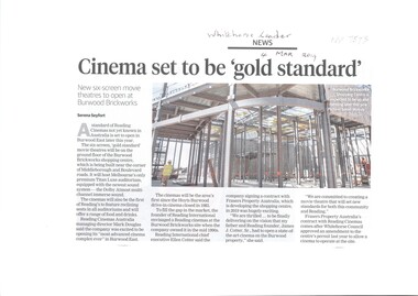
Article, Cinema To Be 'Gold Standard', 2019
A six-screen movie theatre is being built.A six-screen movie theatre is being built on the ground floor at 78 Middleborough Road. Burwood East by Reading Entertainment Australia Pty Ltd as part of the old Nubrick Brickworks site.A six-screen movie theatre is being built. brickworks, theatres, reading entertainment australia pty ltd, burwood east, shopping centres, middleborough road, burwood east, no. 78 -
Bialik College
Mixed media - Displays for the farewell to Shakespeare Grove, 1998, 1998
... sites ...Two boxes and several envelopes containing items from the archives that were displayed at the Farewell to Shakespeare Grove event, 1 December 1998. Inserted in 2024 was a handwritten document that contained quotes from kindergarten children of their experiences of the farewell event. Please contact [email protected] to request access to this record.1990s, campus, sites, history -
 Port Melbourne Historical & Preservation Society
Photograph - J Kitchen & Sons perimeter survey, Munro Street, Dec 2013
As the former j Kitchen & Sons site was being cleared, Lionel Layfield, who had worked at the site for many years undertook several pictorial perimeter surveys. These photos were taken in Dec 2013.Series 1 of colour photographs taken by Lionel Layfield as he walked around the perimeter of the J Kitchen & Sons Pty Ltd factory site during the early demolition of most of the buildings. .09-.15 - from Munro St entrance by the weighbridgeindustry - manufacturing, built environment - industrial, business and traders - soaps/candles, demolitions, j kitchen & sons pty ltd, symex holdings ltd, north port oval, port melbourne cricket and football oval -
 Federation University Historical Collection
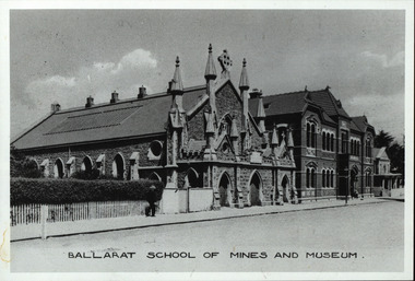
Photograph - Photograph - Black and White, Ballarat School of Mines, c1910, c1910
The Ballarat School of Mines was the earliest site of technical education in Australasia.Ballarat School of Mines from Lydiard Street South. From left to right - the Ballarat School of Mines (Former Wesleyan Church), New Classrooms and Adminsitration Building, Former Circuit Court (site of the first classes in Education in Australia.)ballarat school of mines, ballarat school of mines museum, former ballarat circuit court, former wesleyan church, lydiard street south -
 Melton City Libraries
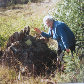
Photograph, The Cairn- Jimmy Melrose's plane crash site, 1988
Edna Barrie at the cairn, photo received from Graeme Minns in 1988. The cairn marks the site of Jimmy Melrose's plane crash in Melton South. The accident which happened on July 5th 1936. In 1934 Melrose made headlines with a series of spectacular flights. In July of that year, he set around Australia record and in that year established a new solo Australia England record when he flew to England to compete in the MacRoberston race with a De Havilland Puss Moth VH- YQO. The only Australian and the only solo pilot to complete the course within the time limit. He was seventh in finishing order and third in the handicap section making news again during the race with a dramatic landing in Darwin with empty fuel tanks. Late in 1935 Melrose imported the Phoenix for his “Adelaide to Anywhere” Charter Service. The previous year the Heston Aircraft Company had taken over the interests of the well known Comper Aircraft Company, and the first production of the new firm was the Phoenix, a single-engined all wooden five seater machine of sesquiplane configuration. The forward half of the fuselage was a streamlined rectangular section and the rear portion was a monocogue shell; the whole was of plywood fabric covered. The wing was built up of spruce box spars and lattice ribs, ply covered from the leading edge to the front spar and the fabric covered over the remainder. The tail surfaces were of similar construction. The most notable feature of the design was the lower stub wing which ran right across the fuselage embodying two box spars, plywood covered it housed the main undercarriage wheels when retracted and provided a substantial anchorage for the Nu form wing struts. The Dowty undercarriage retracted inwards, operated manually by hydraulic packs, Dual control fitted, with side by side seating for the pilots and three passenger seats behind. Power was a 200 h.p. De Havilland Gipsy VI 6 cylinder inverted in-line air-cooled engine. Six Phoenix were built; five of them registered in Great Britain and one of those was later sold abroad the remaining four were impressed into the R.A.F. in 1940. Specifications were: 40 feet 4 inches length 30 ft 2 ins height, 9ft 7ins, wing area 270 sq ft, Tare weight 2,600lbs loaded weight 3,300lbs; cruising speed 360 m.p.h. landing 50mph ceiling 14,000 ft range 700 miles. Melrose’s machine the first production aircraft was built early in 1936 and test flown of the 24th March. Painted green it carries the words “South Australian Centenary 1936” in silver of the fuselage and the name “Billing on the engine cowling in honor of Melrose’s uncle Noel Pemberton Billing, pioneer designer and founder of the Supermarine Aviation Company. The delivery flight was planned as a goodwill mission to publicise the forthcoming South Australian Centenary celebrations. Melrose left Dympne on the 9th April 1936, and flying via Marseilles, Naples, Athens, Baghdad, Basra, Karachi, Jodphur, Calcutta, Akyab, Penang, Singapore, Lombok, Darwin, Newcastle Waters and Alice Springs reached Adelaide on the 25th of April. Continuing the goodwill flight to other States, he visited Melbourne, Sydney, Newcastle, Grafton, Brisbane, Coff’s Harbour, Sydney again, Launceston, Hobart and Mount Gambier before returning to Adelaide on the 13th May. During June Jimmy made some charter flights and early in July was engaged by Mr. A.J. Campbell a director of several mining companies from Melbourne to Darwin to commence at Essendon on the4th July. However on that day low cloud and steady rain caused the postponement. There was little improvement and Melrose was advised to delay the departure again. However he wished to reach Oodnadatta that night, and when he observed the break in the clouds decided to leave. He planned to climb above the cloud and fly to Adelaide at 3,000 feet. The aircraft was airborne about 8.10 a.m. and was last seen from Essendon climbing above the clouds. At 8.45 people at Melton (30 miles West of Melbourne) heard an approaching aircraft. The engine noise increased abnormally and eye witnesses saw the machine fall out of control from the cloud base about 800 feet and then disintegrate, fragments were scattered for 1½ miles and both occupants were killed. Hand written carbon copy by Edna Barrie.Typed by Wendy Barrie March 2014 Last Flight of Jimmy Melrose by John Burke Parade Magazine July 1972 Page 2 –4 This article gives the take off time of 7.50 am from Essendon Airport Eyewitness account at the time Maisie Arthur’s description. Newspaper article. Edna Barrie at the site of the 'Cairn'local identities, local significant events -
 Stawell Historical Society Inc
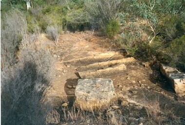
Photograph, Don Rickard, Black Range Quarry Site, 1999
Black Range Quarry SiteOn Reverse Bullocky Mary's House (Mary Honan) 1. Black Range. Campbell's Property Lot 14. Bullocky Mary Rd. quarry site Granite. Nr Cox's Fence. Don Rickard May 1999stawell -
Federation University Historical Collection
Document - Journal Article, Locating the Eureka Stockade: Use of a Geographical Information System (GIS) in a Historiographal Research Context, 2003
Jack Harvey conducted research into the site of the Eureka Stockade. the research was published in 'Eureka Rediscovered'. Jack Harvey is a long term employee at the University of Ballarat.Six pages from the journal Computers and the Humanities 37 229-234, 2003. The article is by J.T. (Jack) Harvey and discusses the use of a Geographical Information System in the search for the Eureka Stockade site.eureka stockade, site, jack harvey, eureka, geographical information system