Showing 532 items matching "south beach"
-
 Mission to Seafarers Victoria
Letter - Correspondence, 19th of March, 1947
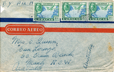
The letter was written by Allen Quinn to his mother. Allen started working as a seafarer when he was 16 years old, and frequently wrote to his mother during his travels. He also created an extensive photograph collection, which corresponds with the letters.The letter is part of an ongoing correspondence between Allan and his mother. In this letter, Allan talks about attending a carnival while in South America.Letter addressed to Mrs S. Quinn, "Sanlorenzo", 63 Ocean Beach, Manly, N.S.W, Australia, in three parts. Part 0156 Envelope Part 0155.1-2 Letter Pages. The envelope and letter pages are tissue-like air mail paper. The letter begins "My Dear Mum, This trip I enjoyed myself..." and concludes with "Your ever loving son, Allan..."In the top right hand corner of the first page is "M.I Ariston, At Sea" and is dated 19/3/47.Front of envelope: BY AIR M[AIL] handwritten in black ink in the top right hand corner, CORREO AEREO printed, MRS S QUINN / SAN LORENZO / 63 OCEAN BEACH / MANLY NSW / AUSTRALIA / AUSTRALIA handwritten in black ink. There are three international stamps, all valued at 10 cents.allan-quinn, letter, handwriting, south-america -
 Mission to Seafarers Victoria
Letter - Correspondence, 10th October, 1947
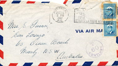
The letter was written by Allan Quinn to his mother. Allen started working as a seafarer when he was 16 years old, and frequently wrote to his mother during his travels. He also created an extensive photograph collection, which corresponds with the letters.The letter is part of an ongoing correspondence between Allan and his mother. In this letter, Allan talks about travelling from South America to Canada, and the ship being fumigated.Letter addressed to Mrs S. Quinn, "Sanlorenzo", 63 Ocean Beach, Manly, N.S.W, Australia, in four parts. Part 0157 Envelope Part 0157.1-3 Letter Pages. The letter pages are tissue-like air mail paper. The letter begins "My Dear Mum, This letter is very late..." and concludes with "Your ever loving son, Allan..." In the top right hand corner of the first page is "M/I Ariston, At Sea" and is dated 10/8/47.On front of envelope: MRS S QUINN / SAN LORENZO / 63 OCEAN BEACH / MANLY NSW / AUSTRALIA handwritten in black ink. VIA AIR MAIL is printed on the right hand side, and there are two Canadian stamps, both valued at 5 cents. There are three stamped postmarks, the first is round: MONTRAL / AUG 14 / 2 PM / 1947 / P.Q., the second is rectangle: -S / -OS / EPAR/ UTILISEZ LA POSTE AERIENNE, the third is also round: T / 60 / CENTIMES. On the back of the envelope: (indecipherable) / 7A6714 / OR 7AA6603 handwritten in pencil.allan-quinn, letter, handwriting, south-america, canada -
 Glenelg Shire Council Cultural Collection
Photograph - Copy Of Photograph - Julia Street - Front Of Old London Inn, Portland, Victoria, 1859
Vern Mc Callum CollectionDigital copy of monochrome photo. Taken in Portland in 1859. View from corner of Julia and Bentinck streets. Looking south. London Inn on right, man on ladder working on corner of building. Henty Beach, jetty, immigration depot, Battery Point. -
Glenelg Shire Council Cultural Collection
Booklet - Booklet - South Western Victoria, n.d
... , faded Forty-two page tourist brochure of South Western Victoria ...Forty-two page tourist brochure of South Western Victoria, produced by Victorian Railways. Contains black and white photos of cities and towns in the south west with a short description of each. Centre page full colour map of area. Blue cover, red print, image of man in bathers on a beach.Front: 'B.W. Vivian', ink, faded -
Glenelg Shire Council Cultural Collection
Photograph - Photograph - aerial view of Portland, c. 1954
Black and white aerial photograph of coastline around Portland. Black border, scale all sides, 5 rows of 3 't' at regular intervals. Half ocean, half land, separated by beach, further left than 8472Front: '607 - 91 ' - handwritten, white, border 'RUN - 6 PORTLAND', printed, white, borderaerial photography, central portland, portland harbour, south west coastline -
Glenelg Shire Council Cultural Collection
Photograph - Photograph - aerial view of Portland, c. 1954
Black and white aerial photograph of coastline around Portland. Black border, scale all sides, 5 rows of 3 't' at regular intervals. 75/25 land to ocean. Further left than 8475, ?end of beach.Front: '607 - 94 ' - handwritten, white, border 'RUN - 6 PORTLAND', printed, white, borderaerial photography, central portland, portland harbour, south west coastline -
Glenelg Shire Council Cultural Collection
Photograph - Photograph - Cape Bridgewater, n.d
Black and white photo of Cape Bridgewater, taken from beach.cape bridgewater, south west coastline, coastline -
Glenelg Shire Council Cultural Collection
Postcard - Postcard - Bentinck St, Portland, Victoria, n.d
Black and white photo postcard. view of Bentinck St. from south of Gawler St. intersection, looking north. Mac's Hotel on left.Back: Handwritten message 'Portland Bentinck (Beach) Street, Mac's Hotel -
Glenelg Shire Council Cultural Collection
Photograph - Photograph - Cape Bridgewater, n.d
Black and white photo of Cape Bridgewater, taken from beachcape bridgewater, seascape, coastline, south west coastline -
Glenelg Shire Council Cultural Collection
Photograph - Photograph - aerial view of Portland, c. 1954
Black and white aerial photograph of coastline around Portland. Black border, scale all sides, 5 rows of 3 't' at regular intervals. Bottom half ocean, top half land, separated by beach, further left than 8471Front: '607 - 90 ' - handwritten, white, borderaerial photography, central portland, portland harbour, south west coastline -
Glenelg Shire Council Cultural Collection
Photograph - Photograph - aerial view of Portland, c. 1954
Black and white aerial photograph of coastline around Portland. Black border, scale all sides, 5 rows of 3 't' at regular intervals. Bottom third is ocean, the rest is land, separated by beach.Front: '607 - 89 ' - handwritten, white, border 'RUN - 6 PORTLAND', printed, white, borderaerial photography, central portland, portland harbour, south west coastline -
Glenelg Shire Council Cultural Collection
Negative - Negative - Nun's Beach, Portland, c. 1934
NEGATIVE FOR BLACK AND WHITE PHOTOGRAPH. View taken from Nun's Beach looking towards Whaler's Bluff.negative, south west coastline, portland, nuns beach -
Glenelg Shire Council Cultural Collection
Photograph - Photograph - aerial view of Portland, c. 1954
Black and white aerial photograph of coastline around Portland. Black border, scale all sides, 5 rows of 3 't' at regular intervals. Bottom half ocean, top land, separated by beach.Front: '607 - 92 ' - handwritten, white, border 'RUN - 6 PORTLAND', printed, white, borderaerial photography, central portland, portland harbour, south west coastline -
Glenelg Shire Council Cultural Collection
Photograph - Photograph - Opening Deep Water Pier 13 Feb 1902, 1902
Black & white photo taken from shore to south pier. Squadron can be seen in background. Railway pier also visible to south of deep water pier. Town beach visible, with fishing fleet at anchor. Road to beach in foreground.Front: VANDA STUDIO, stamped bottom right. Back: EOC Cameron - red biro -
Glenelg Shire Council Cultural Collection
Map - Brochure/Map - Great South West Walk, Oct-83
Brochure/map. Great South West Walk. Track notes for the walk on one side, map showing Great South West Walk on the other, white with blue print and images; map multi-coloured. Front of brochure has photo of Shelley Beach, in blue and white, yellow print, yellow GSWW logo. Back cover yellow, black print. Contact details.great south west walk -
Glenelg Shire Council Cultural Collection
Print - Contact Print - Pastoral Scene, 1960-1979
... right: Dutton Way beach, looking towards south. Bottom left... bushland and beneath bridge. Top right: Dutton Way beach, looking ...Sheet of 4 contact prints from glass plate negatives. Top left: Stream running through bushland and beneath bridge. Top right: Dutton Way beach, looking towards south. Bottom left: Whalers Bluff with lighthouse from Dutton Way. Bottom right: 3 women sitting at small table, taking tea. Outdoor scene, ivy-clad wall behind them. They are dressed in late 19th, early 20th century fashion. -
Glenelg Shire Council Cultural Collection
Photograph - Sheet of 12 contact prints of rephotographed photographs - Various Portland land marks, c. 1970
Sheet of 12 contact prints of rephotographed photographs. Identifying numbers 5725 a, b, c, d, e, f, g, h, i, j, k, l (a) Bentinck Street from sea (b) James Robertson store (c) Bentinck Street south from All Saints (d) Fawthrop Lagoon (e) Henty Beach Cliffs (f) Bridge over Salt Creek (g) Res. Dr. C. Grier, Julia Street (h) Group of men sitting/standing outside wooden building (i) Henty Woolstores, Julia Street (j) S.S 'Dawn' tied up to railway pier (k) All Saints Catholic Church (l) Cliffs at Henty Streetfrom the front: (b) James Robertson store (c) Bentinck Street, Portland - Nicholls (e) Cliffs above Henty Street (f) Bridge over Portland drain (i) Henty Woolstore and Observer buildings, Julia Street -
 Warrnambool and District Historical Society Inc.
China, Spoon Rest, Early 21st century
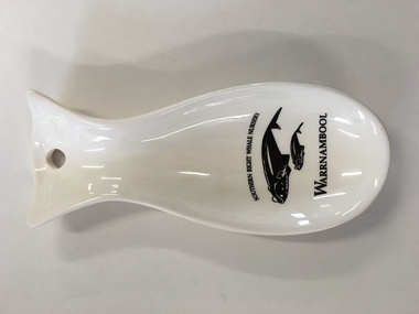
This spoon rest is a souvenir item for tourists to purchase. It is a souvenir of the presence of Southern Right whales at Logans Beach, a few kilometres from Warrnambool’s Central Business District. Each year Southern Right whales have been migrating from sub-Antarctic waters to the east coast of Australia during the winter months. Some whales have been coming each year from approximately May to October (since the 1980s) to have their calves at Logans Beach near Warrnambool. This area is now known as Warrnambool’s Southern Right Nursery. The whales calve about every three years and stay in the local waters along with other whales for about three months and over the past thirty years or so over 100 calves have been born at Logans Beach. The whales are now a winter tourist attraction (if an unpredictable one) as they can be viewed from a raised purpose-built platform area and they are often very close to the shore.This spoon rest is of interest as it is a souvenir of the Southern Right Whale Nursery at Logans Beach, Warrnambool and it has a practical use in the kitchen. It indicates the popularity of whale-viewing at Logans Beach and the importance of the presence of the whales, both scientifically and economically as the annual whale migration to our waters is now a vital aspect of tourism in Warrnambool. This is a Warrnambool souvenir cream-coloured china spoon rest in the shape of a whale or fish. It has a hole at the top for hanging the item on a hook and the printed material is in black and includes a sketch of a mother whale and calf. It has the distributor’s name on the back in yellow writing with an outline of a map of Victoria with a dot to show the location of Warrnambool.‘Southern Right Whale Nursery, Warrnambool’ ‘Lady Bay Creations, Warrnambool, Australia’ southern right whales, warrnambool’s southern right whale nursery, history of warrnambool -
 Warrnambool and District Historical Society Inc.
Booklet, Beyond the Point, 2007
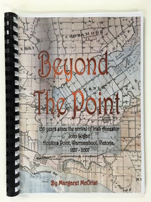
This book was written in 2007 by Margaret McOrist to mark the 150th anniversary of the arrival in the Warrnambool area of John Logan. It is a sequel to a 1991 book, ‘Clotted Cream and Mangels’ which told the story of John Logan and his wife Mary Gardner. They lived at Hopkins Point, Warrnambool and the book, ‘Beyond the Point’ tells the story of the Logan descendants. When the farm land was sub-divided and sold the nearby beach was named ‘Logans Beach’. This book is of considerable interest as it tells the story of the descendants of important early settlers, John Logan and Mary Gardner. The area where they first settled is now of major interest as Logans Beach (named for the Logan family) is the well-known whale watching area. Southern Right Whales return to this beach each year and the females calve and remain up to three months at this beach, making it an important ‘whale nursery’. This is a soft cover book with black plastic ring binding and clear plastic sheets covering the front and back paper covers. The front cover has a reproduction of an 1891 map of Warrnambool and district with the title of the book and other information superimposed on the map. The back cover is black. The book has 101 pages and contains information on the Logan families who lived at Tooram in Allansford and their descendants. There are many black and white and colour photographs, diagrams, maps and family trees. Front Cover: ‘Beyond the Point, 150 years since the arrival of Irish ancestor, John Logan, Hopkins Point, Warrnambool, Victoria, 1857-2007, by Margaret McOrist’. john logan and mary gardner, hopkins point, logans beach, tooram, history of warrnambool -
 Warrnambool and District Historical Society Inc.
Postcard - Views of Warrnambool
Pictures depicting scenes of Warrnambool & District. 9 pictures are, The Beach. Hopkins River. Thunder Point. Liebig St. Botanical Gardens. Breakwater and pier. Hopkins River. Soldiers Memorial. Hopkins Falls.A typical souvenir postcard from the 1930'sOblong postcard with flip down views of Warrnambool from a purse with two kittensValentine's Mail Novelty Post Card; Good Luck And a Bagful of Views from WARRNAMBOOLwarrnambool, hopkins river, warrnambool breakwater, warrnambool postcards, postcards, hopkins falls, thunder point, soldiers memorial -
 Warrnambool and District Historical Society Inc.
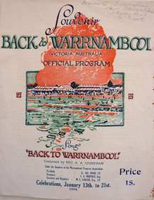
Programme - Back to Warrnambool Souvenir program, 1934
This program provides information for the week of festivities in 1934The Back to celebrations were an important event on the social calendar and this program gives an insight into the kinds of events which were prevalent during the early to mid 20th century. White cover printed in dark blue with red and green accents. Picture of Warrnambool main beach centre front. Back cover is in black and white, Black text at the top reads Warrnambool the Capital City of the West—The city Beautiful. Underneath is a large photo of the Hopkins Falls. The inside four pages contain a brief history of the city, the program for the week and words of the song Back to Warrnambool. A map is on the inside back cover.Particulars supplied by the W’bool Progress Association.warrnambool, back to warrnambool, 1934 official program, reg. a. a. stoneham., reginald alberto agrati stoneham, 1934, program, programme -
 Warrnambool and District Historical Society Inc.
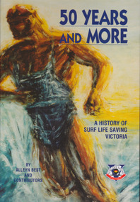
Book, BPA Print group Pty Ltd, 11 Evans St Burwood, Vic 3125, 50 Years and More A History of Surf Life Saving Victoria, First published 2002
History of Life Saving Victoria for over 50 yearsBlue and gold hard cover with stylized figure of life saver on front cover with multi coloured blue cover on back with small boxed copy of front cover figure. Taken from painting Beltman and Co by Brian St Alban Smith 1958. 548 pages followed by lists of award winners both individuals and clubs. Title and authors in dark blue text.History of Life Saving Victoria for over 50 yearswarrnambool, surf life saving victoria, surf championships, shark attacks, surf boats -
 Warrnambool and District Historical Society Inc.
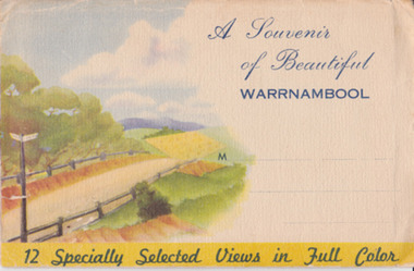
Souvenir - Post Card 12 views of Warrnambool, Nucolorvue Productions, 1950's
This type of folded postcards was popular with tourists in the 1940s, 50s, and 60s and often kept by them for many years afterwards. The views of Warrnambool here, taken about the 1950s, were typical of the Warrnambool postcards available at the time and were mass-produced as many examples survive today. They include photographs of Hopkins Falls, the beach and harbour, Liebig Street, Hopkins River, coastal scenery and the Botanical Gardens. These postcards are of some historical interest, though the photographs appear frequently in many publications. They also have a social significance showing what tourists bought 60 or more years ago.This is a packet in envelope form containing 12 coloured postcards of views of Warrnambool about the 1950s. The photographs are printed on buff-coloured paper and fold up to envelope size so that they can be sent by post. The front cover includes three dotted lines for the address and the back cover has a space to include the name of the sender. One page gives some general information on Warrnambool. Front cover: ‘A Souvenir of Beautiful Warrnambool’, ’12 Specially Selected Views in Full Color’ Back cover: ‘From…’ , ‘Published by Nucolorvue Productions, Elwood, Victoria’ tourism, warrnambool -
 Warrnambool and District Historical Society Inc.
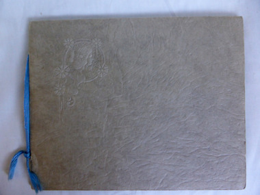
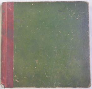
Album - Views of Warrnambool
The album contains postcards (photographs). The photographs (postcards) of Warrnambool and district in the 1930s/40s include views of the Botanic Gardens, the coast line, the main streets, the War Memorial and Hopkins Falls. The postcards from the 1890s include Wilmot, the Hopkins River, Hopkins Falls and Shelly Beach.The postcards in the album are in good condition and will be useful for reproduction. The 1930s/40s collection of photographs (also postcards) is a useful one also and a good example of how people preserved mementoes of their visit to a town. All the photographs are contained in other collections or albums held elsewhere in the Historical Society collection.This is a photograph album of ten pages with a buff-coloured cover of thickened card with a raised surface and an embossed image of a woman in the left corner of the front page. There are five postcards attached to the inside covers and 31 other photographs (postcards) in the slots provided. One photograph is missing from these slots. Embossed ornately decorated image of a woman on the front cover. postcards and photographs, warrnambool 1930s/1940s -
 Warrnambool and District Historical Society Inc.
Photograph - Album, Copies of photos, Circa mid 20th century
This album is possibly a collection printed from newspaper files. It has a wide variety of local scenes from haymaking, sports, social functions, beach scenes. Some names have been written in greylead, identifying some of the people in the photos and others are recognizable backgrounds such as the Peterborough Golf ClubWhile these images are not of true photographic quality, they do provide images of local scenes and activities which were relevant to the area in the mid 20th century. Some such as lifesaving carnivals, bike riding and golf continue to this day, others showing the hand raking of hay are long gone.Green card cover with red binding. This album contains printed copies of local scenes and people. The photos are numbered in purple pencil from1 to 312. The first photograph in the book is The Needle at Childers Cove and the last page is a group of people behind a picket fence.warrnambool, photographs of warrnambool, newspaper photographs warrnambool -
 Australian National Surfing Museum
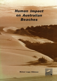
Document, Human Impact on Australian Beaches (Results from SOS95 Beach Survey), 1/5/1996 (estimated)
Human Impacts on Australian Beaches was a landmark environmental study which provided a 'snapshot' of the health of 1612 beach areas around Australia. This nationwide study (which built on the success of the 1994 State of Our Surf Report) was put together by the Surfrider Foundation Australia with the support of more then 340 individuals and 70 organisations around Australia. The report was authored by surfer/environmentalist/artist Michael Legge-Wilkinson from Newcastle, New South Wales. Human Impacts was launched officially by Peter Garrett, leader of Australian rock band Midnight Oil at the Bondi Pavilion, Bondi Beach in May 1996.Human Impacts built on the success of the 1994 State Of Our Surf Report, released by the Surfrider Foundation Australia in 1994. Human Impacts was the first major report to specifically examine the environmental health of 1612 of Australia's beaches. A limited 500 copies of this report were produced, the majority of which went to education institutions, libraries, community groups and government departments. The report generated national and international media interest with the BBC London reporting on its findings in the week after its launch.Beach Environmental Report. 168 page report which examines the health of 1612 beach areas around Australia. Sepia cover featuring a photograph of endangered sanddunes at Stockton Bight, north of Newcastle. 168 pagesSepia cover, Surfrider Foundation logo on report coverbeach, surfrider foundation australia, human impacts on beaches, sos95, michael legge wilkinson, coastal development, beach pollution -
 Australian National Surfing Museum
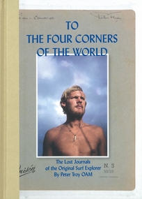
Book, Flying Pineapple Media, To The Four Corners Of The World, 1/1/2011 (estimated)
This book is the definitive history of the surf travels by Peter Troy. Troy's travels are the stuff of legends. An original and influential figure in the early days of surfing at Bells Beach, Troy left Australia in 1963 and roamed the planet with surfboard under arm from Europe to Hawaii, South America to South Africa, introducing surfing to Brazil and discovering untold perfect waves like Nias off the coast of Sumatra. He documented every step of this remarkable journey in letters home which were rediscovered after his untimely death in 2008.This book represents the major surf travel history of one of the great legends in world surfing Peter Troy from Torquay. In 1962 Troy was one of the founders of the Bells Beach Surf Contest, the longest running surf contest in the world. He was an intrepid surf traveller who during the period 1963-1966 introduced surfing to the country of Brazil and explored the four corners of the globe for waves. This book is a unique record of world travel by surfer(s)during this period.Full colour, hard bound travel surf book by Peter Troy OAM, edited by Brendan McAloon. Colour cover image of a young Peter Troy by Rennie Ellis.ISBN - 978-0-9808480-0-7torquay, rod brooks, surf, bells beach, peter troy, rennie ellis, hawaii, nias, vic tantau, terry wall, bells beach surf contest, brazil, world surfing championships, biarritz, european surfing championships, flying pineapple media, sean doherty -
 Flagstaff Hill Maritime Museum and Village
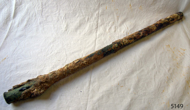
Nail
The iron-hulled, four-masted barque, the Falls of Halladale, was a bulk carrier of general cargo. She left New York in August 1908 on her way to Melbourne and Sydney. In her hold, along with 56,763 tiles of unusual beautiful green American slates (roofing tiles), 5,673 coils of barbed wire, 600 stoves, 500 sewing machines, 6500 gallons of oil, 14400 gallons of benzene, and many other manufactured items, were 117 cases of crockery and glassware. Three months later and close to her destination, a navigational error caused the Falls of Halladale to be wrecked on a reef off the Peterborough headland at 3 am on the morning of the 15th of November, 1908. The captain and 29 crew members all survived, but her valuable cargo was largely lost, despite two salvage attempts in 1908-09 and 1910. ABOUT THE ‘FALLS OF HALLADALE’ (1886 - 1908) Built: in1886 by Russell & Co., Greenock shipyards, River Clyde, Scotland, UK. The company was founded in 1870 (or 1873) as a partnership between Joseph Russell (1834-1917), Anderson Rodger and William Todd Lithgow. During the period 1882-92 Russell & Co., standardised designs, which sped up their building process so much that they were able to build 271 ships over that time. In 1886 they introduced a 3000 ton class of sailing vessel with auxiliary engines and brace halyard winches. In 1890 they broke the world output record. Owner: Falls Line, Wright, Breakenridge & Co, 111 Union Street, Glasgow, Scotland. Configuration: Four masted sailing ship; iron-hulled barque; iron masts, wire rigging, fore & aft lifting bridges. Size: Length 83.87m x Breadth 12.6m x Depth 7.23m, Gross tonnage 2085 ton Wrecked: the night of 14th November 1908, Curdies Inlet, Peterborough south west Victoria Crew: 29 The Falls of Halladale was a four-masted sailing ship built-in 1886 in Glasgow, Scotland, for the long-distance cargo trade and was mostly used for Pacific grain trade. She was owned by Wright, Breakenridge & Co of Glasgow and was one of several Falls Line ships, all of which were named after waterfalls in Scotland. The lines flag was of red, blue and white vertical stripes. The Falls of Halladale had a sturdy construction built to carry maximum cargo and able to maintain full sail in heavy gales, one of the last of the ‘windjammers’ that sailed the Trade Route. She and her sister ship, the Falls of Garry, were the first ships in the world to include fore and aft lifting bridges. Previous to this, heavily loaded vessels could have heavy seas break along the full length of the deck, causing serious injury or even death to those on deck. The new, raised catwalk-type decking allowed the crew to move above the deck stormy conditions. This idea is still used today on the most modern tankers and cargo vessels and has proved to be an important step forward in the safety of men at sea. On 4th August 1908, with new sails, 29 crew, and 2800 tons of cargo, the Falls of Halladale left New York, bound for Melbourne and Sydney via the Cape of Good Hope. The cargo on board was valued at £35,000 and included 56,763 tiles of American slate roofing tiles (roof slates), 5,673 coils of barbed wire, 600 stoves, 500 sewing machines, 6,500 gallons of oil, 14,400 gallons of benzene, plumbing iron, 117 cases of crockery and glassware and many other manufactured items. The Falls of Halladale had been at sail for 102 days when, at 3 am on the night of 14th November 1908, under full sail in calm seas with a six knots breeze behind and misleading fog along the coast, the great vessel rose upon an ocean swell and settled on top of a submerged reef near Peterborough on the south-west Victoria’s coast. The ship was jammed on the rocks and began filling with water. The crew launched the two lifeboats and all 29 crew landed safely on the beach over 4 miles away at the Bay of Islands. The postmistress at Peterborough, who kept a watch for vessels in distress, saw the stranding and sent out an alert to the local people. A rescue party went to the aid of the sailors and the Port Campbell rocket crew was dispatched, but the crew had all managed to reach shore safely by the time help arrived. The ship stayed in full sail on the rocky shelf for nearly two months, attracting hundreds of sightseers who watched her slowly disintegrate until the pounding seas and dynamiting by salvagers finally broke her back, and her remains disappeared back into deeper water. The valuable cargo was largely lost, despite two salvage attempts in 1908-09 and 1910. Further salvage operations were made from 1974-1986, during which time 22,000 slate tiles were recovered with the help of 14 oil drums to float them, plus personal artefacts, ship fittings, reams of paper and other items. The Court of Marine Inquiry in Melbourne ruled that the foundering of the ship was entirely due to Captain David Wood Thomson’s navigational error, not too technical failure of the Clyde-built ship. The shipwreck is a popular site for divers, about 300m offshore and in 3 – 15m of water. Some of the original cargo can be seen at the site, including pieces of roof slate and coils of barbed wire. The Falls of Halladale shipwreck is listed on the Victorian Heritage Register (No. S255). She was one of the last ships to sail the Trade Routes. She is one of the first vessels to have fore and aft lifting bridges. She is an example of the remains of an International Cargo Ship and also represents aspects of Victoria’s shipping industry. The wreck is protected as a Historic Shipwreck under the Commonwealth Historic Shipwrecks Act (1976).25½" of round solid copper nail. Recovered from "Falls of Halladale". Ship's nail.flagstaff hill, warrnambool, shipwrecked coast, flagstaff hill maritime museum, maritime museum, shipwreck coast, flagstaff hill maritime village, great ocean road, nail, copper nail, falls of halladale, ship's nail -
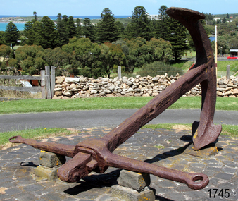 Flagstaff Hill Maritime Museum and Village
Equipment - Anchor, Circa 1886
The anchor is one of four that were carried by the FALLS OF HALLADALE when she was wrecked near Peterborough in 1908. This Rodger’s Anchor was raised from the wreck site by Flagstaff Hill divers (Peter Ronald, Colin Goodall and Gary Hayden) in 1974 and is on permanent outdoor display at the Maritime Village. The imposing 2-tonne artefact required a raft of fourteen 44-gallon drums to raise it from the seabed before it was towed by a crayfish boat to the wharf crane at Port Campbell for loading onto land transport. Following Lieutenant William Rodger’s patent in 1831, anchor design moved away from the separate attachment of straight arms and flat flutes to each side of a long shaft. Rodger’s innovation included the forging of both arms and their flutes as a single uniformly curved piece which was then attached to the crown of the shank by a thick horizontal bolt. The two-inch diameter hole for the securing through-bolt at the crown is clearly visible in this example, the bolt dislodged by corrosion and now missing. The FALLS OF HALLADALE was a four-masted, iron-hulled barque, built by Russell and Co at Greenock in 1866 for the Falls Line of Wright & Breakenridge, Glasgow. The ship was 275 feet long, 42 feet wide, with a 24 feet draft and weighed 2,085 tonnes. She was built to carry as much cargo as possible rather than for speed. Her unmistakably square bilge earned her the title of “warehouse-type” ship and her iron masts and wire rigging enabled her to maintain full sail even in gale conditions. In 1908, with new sails, 29 crew, and 2800 tons of cargo in her hold, the FALLS OF HALLADALE left New York, bound for Melbourne and Sydney via the Cape of Good Hope. 102 days later, at 3 am on the 14th of November, under full sail and in calm seas, with a six knots breeze behind and a misleading fog along the coast, the great vessel rose upon an ocean swell and settled on top of a shelf of rock near Peterborough. There she stayed for nearly two months until the pounding seas and dynamiting by salvagers finally broke her back, and her remains disappeared back into deeper water. The iron-hulled, four-masted barque, the Falls of Halladale, was a bulk carrier of general cargo. She left New York in August 1908 on her way to Melbourne and Sydney. In her hold, along with 56,763 tiles of unusual beautiful green American slates (roofing tiles), 5,673 coils of barbed wire, 600 stoves, 500 sewing machines, 6500 gallons of oil, 14400 gallons of benzene, and many other manufactured items, were 117 cases of crockery and glassware. Three months later and close to her destination, a navigational error caused the Falls of Halladale to be wrecked on a reef off the Peterborough headland at 3 am on the morning of the 15th of November, 1908. The captain and 29 crew members all survived, but her valuable cargo was lost, despite two salvage attempts in 1908-09 and 1910. ABOUT THE ‘FALLS OF HALLADALE’ (1886 - 1908) Built: in1886 by Russell & Co., Greenock shipyards, River Clyde, Scotland, UK. The company was founded in 1870 (or 1873) as a partnership between Joseph Russell (1834-1917), Anderson Rodger and William Todd Lithgow. During the period 1882-92 Russell & Co., standardised designs, which sped up their building process so much that they were able to build 271 ships over that time. In 1886 they introduced a 3000-ton class of sailing vessel with auxiliary engines and brace halyard winches. In 1890 they broke the world output record. Owner: Falls Line, Wright, Breakenridge & Co, 111 Union Street, Glasgow, Scotland. Configuration: Four-masted sailing ship; iron-hulled barque; iron masts, wire rigging, fore & aft lifting bridges. Size: Length 83.87m x Breadth 12.6m x Depth 7.23m, Gross tonnage 2085 ton Wrecked: the night of 14th November 1908, Curdies Inlet, Peterborough south west Victoria Crew: 29 The Falls of Halladale was a four-masted sailing ship built in 1886 in Glasgow, Scotland, for the long-distance cargo trade and was mostly used for the Pacific grain trade. She was owned by Wright, Breakenridge & Co of Glasgow and was one of several Falls Line ships, all of which were named after waterfalls in Scotland. The lines flag was of red, blue and white vertical stripes. The Falls of Halladale had a sturdy construction built to carry maximum cargo and able to maintain full sail in heavy gales, one of the last of the ‘windjammers’ that sailed the Trade Route. She and her sister ship, the Falls of Garry, were the first ships in the world to include fore and aft lifting bridges. Previous to this, heavily loaded vessels could have heavy seas break along the full length of the deck, causing serious injury or even death to those on deck. The new, raised catwalk-type decking allowed the crew to move above the deck in stormy conditions. This idea is still used today on the most modern tankers and cargo vessels and has proved to be an important step forward in the safety of men at sea. On 4th August 1908, with new sails, 29 crew, and 2800 tons of cargo, the Falls of Halladale left New York, bound for Melbourne and Sydney via the Cape of Good Hope. The cargo on board was valued at £35,000 and included 56,763 tiles of American slate roofing tiles (roof slates), 5,673 coils of barbed wire, 600 stoves, 500 sewing machines, 6,500 gallons of oil, 14,400 gallons of benzene, plumbing iron, 117 cases of crockery and glassware and many other manufactured items. The Falls of Halladale had been at sail for 102 days when, at 3 am on the night of 14th November 1908, under full sail in calm seas with a six knots breeze behind and misleading fog along the coast, the great vessel rose upon an ocean swell and settled on top of a submerged reef near Peterborough on the south-west Victoria’s coast. The ship was jammed on the rocks and began filling with water. The crew launched the two lifeboats and all 29 crew landed safely on the beach over 4 miles away at the Bay of Islands. The postmistress at Peterborough, who kept a watch for vessels in distress, saw the stranding and sent out an alert to the local people. A rescue party went to the aid of the sailors and the Port Campbell rocket crew was dispatched, but the crew had all managed to reach shore safely by the time help arrived. The ship stayed in full sail on the rocky shelf for nearly two months, attracting hundreds of sightseers who watched her slowly disintegrate until the pounding seas and dynamiting by salvagers finally broke her back, and her remains disappeared back into deeper water. The valuable cargo was largely lost, despite two salvage attempts in 1908-09 and 1910. Further salvage operations were made from 1974-1986, during which time 22,000 slate tiles were recovered with the help of 14 oil drums to float them, plus personal artefacts, ship fittings, reams of paper and other items. The Court of Marine Inquiry in Melbourne ruled that the foundering of the ship was entirely due to Captain David Wood Thomson’s navigational error, not too technical failure of the Clyde-built ship. The shipwreck is a popular site for divers, about 300m offshore and in 3 – 15m of water. Some of the original cargo can be seen at the site, including pieces of roof slate and coils of barbed wire.The shipwreck of the FALLS OF HALLADALE is of state significance – Victorian Heritage Register No. S255. She was one of the last ships to sail the Trade Routes. She is one of the first vessels to have fore and aft lifting bridges. She is an example of the remains of an International Cargo Ship and also represents aspects of Victoria’s shipping industry. The wreck is protected as a Historic Shipwreck under the Commonwealth Historic Shipwrecks Act (1976).A large iron Rodger’s anchor recovered from the wreck of the FALLS OF HALLADALE. It has a rounded crown, curved arms and moulded flutes. Heavy duty iron stock with round eyes at either end, fitted over shank and fixed into position by a wedge-shaped metal locking pin. Shackle missing but severed securing bolt remaining in shank. The presence of an empty bolthole at the crown junction of shank and arms confirms Rodger’s type. Corroded from 66 years submersion in seawater but otherwise structure is sound.warrnambool, shipwreck coast, flagstaff hill, shipwrecked coast, flagstaff hill maritime village, flagstaff hill maritime museum, shipwreck artefact, maritime museum, falls of halladale, rodger’s anchor, peterborough reef, 1908 shipwreck, anchor, last days of sail, great clipper ships -
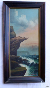 Flagstaff Hill Maritime Museum and Village
Painting - Oil painting, W. Langley-Taylor, Eagle Rock, Warrnambool, Vic, Late 19th to early 20th century
This painting is one of a pair of large paintings by W. Langley-Taylor in our collection. Currently, no further information has been found about the artist but research is ongoing. The subjects of these paintings are seascapes of notable areas of the coast on each side of Port Phillip Bay, south of Melbourne, Victoria. This painting is of Eagle Rock, Warrnambool, which is on the west of Port Phillip Bay. Eagle Rock is located about 400 metres west of Thunder Point, near Shelly Beach. The painting includes the rocky cliff formations looking east towards the Warrnambool Breakwater. The walk from the Thunder Point car park westwards to Shelly Beach has been popular over the decades with residents as well as tourists. Many photographs include the rock, with varying backgrounds depending on the angle of the camera. It is a popular dive site for locals and visitors, in calm weather! The site can be approached by boat from the open sea in favourable conditions, and there is plenty of native marine to be seen in this marine sanctuary. This part of Warrnambool’s rugged coastline is unprotected from the Southern Ocean with its wild icy winds and high seas. The painting’s crashing waves and the northerly direction of the smoke on the steamship sailing north show the effect of the southerly wind. INSCRIPTIONS “Mrs M Irby” and “980/Regency” The significance of the inscription “Mrs M Irby”, on the back of each of the two paintings, has not yet been discovered. Perhaps she was connected with the ship or shipping company “Irby”. A ship named “Irby”, built in Merseyside, Liverpool in 1881 by R & J Evans, Birkenhead. It was a four-masted iron ship built for the White Star Line. Henry Wilson Hewitt bought her in 1882, then later she was owned by Chadwick & Pritchard. In 1888 she was registered under the Irby Ship Co. Ltd. (trading as J. Joyce) in Liverpool. In 1912 Galgate Co. Ltd owned her. She traded between London, England and Australia, and is recorded as being in Melbourne and Hobart. In 1919 the Irby was destroyed by a mine when on her way to England. Or perhaps her name and the inscription in pencil “980/Regency” on the Eagle Rock Warrnambool, painting could be a delivery address for the paintings, perhaps an apartment in a hotel. This painting is significant geographically for its representation of the coastal scenery of Victoria, Australia. It is also significant as one of a pair of paintings of seascape, one at sites each side of Port Phillip Bay. The painting is significant historically as an example of late 19th and early 20th methods and materials used to construct a painting’s frame. Painting oil on board in a dark wooden frame, portrait orientation. Seascape of rock formation and cliffs, two yachts, a two-masted steamboat with red funnel and smoke, flying birds, high waves breaking onto rocks, blue sky with clouds, some tinted pink.. The title is painted on lower left corner and the artist, W. Langley-Taylor, has signed his name on lower right. The inscription on the back is a handwritten script in red crayon or thick red pencil. The board is held in place inside the timber frame with small, dark metal tacks around all sides. Metal eyes join the wire to the frame. Small round, dark metal nail heads are dispersed around the frame and there is a change of colour on both the board and the wood of the frame. Painted on front “W.LANGLEY-TAYLOR.” and “EAGLE ROCK, WARRNAMBOOL, VIC.” Handwritten on back “Mrs. M. Irby” and “980 [underlined] Regency”flagstaff hill, warrnambool, shipwrecked coast, flagstaff hill maritime museum, maritime museum, shipwreck coast, flagstaff hill maritime village, great ocean road, eagle rock warrnambool, w. langley-taylor, oil painting, wall decoration, seascape of victoria's coast, mrs m irby, art, seascape, pair of paintings