Showing 571 items
matching st just
-
 Stawell Historical Society Inc
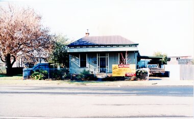
Photograph, House Removal. Victoria Street Rob Holloway, July 1996
7103 - House with auction removal sign. -1 The view across the road to central park -2 View from the side showing seedling house and Stawell Bowling club -3 Showing the house on the truck looking towards the cab of the truck. -4 Looking back towards the house on the truck -5 The house on the truck just before turning a corner6 colour photographs showing the parks and gardens superintendents house streetscape -
 Stawell Historical Society Inc
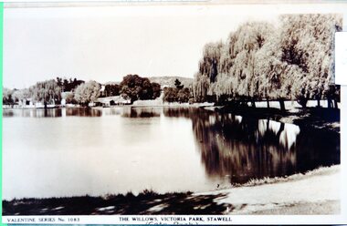
Photograph - View of Cato Lake, Black & White photo of Valentine Series No 1083 Willows Victoria/Cato Lake
View of Victoria/Cato Lake showing just a short section of the walking track and willows around the lake. Houses can be seen in the distance. The lake is very still as the trees are reflected in the water.Black & White photo of Valentine Series No 1083 Victoria/Cato lake. The photo is of a post card of Victoria/Cato Lake. Willow trees line the right side of the photograph. Valentine Series No 1083. The willows Victoria Park, Stawell. stawell -
 Stawell Historical Society Inc
Map - Laminated Map, Country Fire Authority, Mt Lubra and Deep Lead Fires Estimated Perimeters 2005 - 2006, 17/3/2006
Huge Fire Event in Grampians started by lightning strike at Mt Lubra on 19/1/2026 during a prolonged dry period. Stawell Deep Lead fire 31/12/2005 just three weeks earlier. Two people died on Moyston / Pomonal Road. Huge stork and feed loss.Coloured Laminated Map of Fire SpreadCFA GIS Services Community Safety -
 Stawell Historical Society Inc
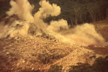
Slide, Ian McCann, JUst after Blasting on the Eastern sideof Lake Bellfield, 1965
Lake Bellfield Under ConstructionColour Slide: Jast After blasting on the Eastern Side of lake Bellfield with Debris still airbourne.grampians -
 Stawell Historical Society Inc
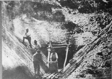
Photograph, Water Supply Tunnel -- during Construction with 4 men working at tunnel entrance
Water Supply Tunnel. Four men working at Tunnel entrance. Grampians Range near Pomonal. Two men are working on the side of the embankment and the other 2 are working just outside the tunnel entrance. Four men working at the water supply tunnel entrance in Grampians Range near Pomonal.stawell grampians -
 Stawell Historical Society Inc
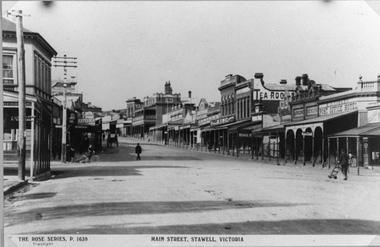
Photograph, Main Street Stawell looking East towards the Post Office
This photograph is of Main Street Stawell looking East around c 1920's. The photo was taken from just below Main & Wimmera Street corner. On the left side is the two story Post Office building. The photograph shows the telegraph poles in the street. Also Copley Post Office Hotel 1912- 22 and other business. On the road are a few people one pushing a trolly, one on a bike and two people in a horse drawn cart. Gustav Mahnke's Bakery is on right.Two Black & White photographs depicting the main street in Stawell's commercial business area in c 1920's. The view shows some two story buildings, shops with verandah's. One horse drawn vehicle, a person on a bike and a few people in the street. There is also a paper print of the photograph donated by Robyn Mackenzie Bacchus Marsh in 2009 The Rose series, P 1639 Main Street, Stawell, Victoriastawell business shops streetscape -
 Stawell Historical Society Inc
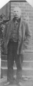
Photograph, Male portrait Charles Hunt Smith
Charles Hunt Smith (Court House Residence). This photograph taken around 1914 belongs to the Smith Family. Donated to the society by Mr. Bill Smith. The photo is of his father who was a builder and lived at Pleasant Creek Court house.Photograph of an elderly man dressed in jacket, waistcoat & tie. He is standing in front of a brick building and below 3 steps. The original photo is a sepia colour and cut down just to include the gentleman with an enlarged black and white copy on card with the photo.Dad's father Charles Hunt Smith.stawell -
 Stawell Historical Society Inc
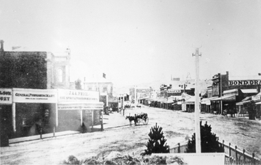
Photograph, Main Street looking East from Coffee Palace area 1880
Main Street Looking East 1880 from weigh bridge area, taken from Coffee Palace verandah. Two story buildings with veranda's. Horse drawn vehicle center of image. Post office and Town Hall visible in background. Bond Drapery. J & A Price Wine Spirits. Bond Draper sign on right. Two Poppet Heads on Big Hill are the No2 North Waterloo and the Waterloo and Argyle Mines.Black and white photograph looking East along Main Street from Weighbridge area where two streets join. Horse drawn buggy in center of street with buggy. Big Hill in distance with two poppet heads just visible.stawell businesses streetscape -
 Stawell Historical Society Inc
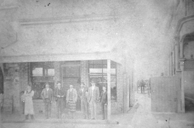
Photograph, Cooper Bros Butcher Shop in Main Street Stawell c1920
Cooper Bros. Butcher Shop Main Street Stawell c1920. Seven men standing under shop veranda. Down the lane way on the right is a horse and cart just visible with the wheel of another cart in front but behind the gate of the lane way. Black and white photograph of a business. Seven people standing under the veranda. Two of the people have aprons on one with horizontal stripes. There are carts in the lane way. stawell business -
 Stawell Historical Society Inc
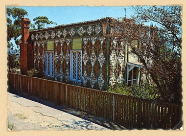
Photograph, Diamond House -- Coloured
Stawell Diamond House post cards by NucolorVue productions. Two colour postcards of the Diamond House. There is also a more recent colour photograph of the Diamond House in Album 8. The photo in Album 8 was taken from the road with a car just visible on the road it also has a Restaurant sign on the side of the building.A Nu-Color-Vue of Australia ST7- Nucolorvue Productions Pty. Ltd. Copyright stawell -
 Stawell Historical Society Inc
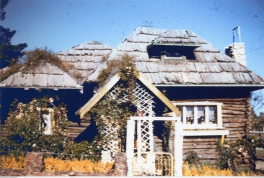
Photograph, Log Cabin c 1930's -- Coloured
Colour photo Log Cabin built by J Wharrie during 1930s. The photo was taken from a colour slide from Allan Howells Collection. Photo taken c 1960 -70.Log Cabin built by Mr. J. Wharrie during the 1930's. This photo is a front view of the house with vine growing over the porch and bark roof. A weather vane can be just made out on the roof. stawell dwelling -
 Stawell Historical Society Inc
Photograph, McKellar Building in Upper Main Street Stawell in c 1992
Coloured photo McKellar Building c 1876. The colour photo was taken in 1992. The information in Album 4 page 40 states the building was built after fires of c 1866 & 1874. Mr. George Inskip was the architect of the McKellar building.Two colour copies of the McKellar building taken by Geoff Oates in 1992. The two identical photos just show the upper two stories of the building. Stawell 1876 Building Gold Reef Mall. Nov 1992 stawell business -
 Stawell Historical Society Inc
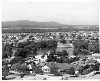
Photograph, Cato Lake from top of clock tower c 1965
Photo taken from top of clock tower c 1965 looking South West. Black Range in background. Stawell West State School is in the far top right just in front of a band of trees. The swimming pool is hidden by pine trees in the center of the lake and identified but a line of flag posts either side of the pool.Aerial black and white view of Cato lake. One photo is original and the other a copy. The photo was taken from the top of the clock tower looking South West. c 1965.stawell, streetscape -
 Stawell Historical Society Inc
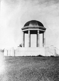
Photograph, Pioneers’ Memorial on Big Hill possibly just after construction
Pioneers’ Memorial possibly just after construction. The foundation stone was "laid" in 1935.Black and white photo of Pioneers' memorial at Big Hill possible just after completed as no scaffolding under dome. stawell -
 Stawell Historical Society Inc
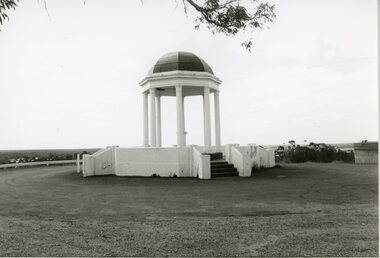
Photograph, Pioneer Memorial on Big Hill looking North
Pioneer Memorial Looking NorthBlack and White photograph of Pioneer Memorial Tree branch visible at top. Tin shed just visible on rightstawell -
 Stawell Historical Society Inc
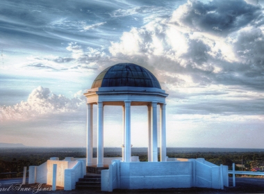
Photograph, Pioneer Memorial on Big Hill looking North West -- Coloured
Pioneer Memorial looking Northwest with a spectacular sky background. The foundation stone of the memorial was laid in c 1935.Colour photograph of the magnificent Pioneers Memorial on Big Hill. View is looking toward the Northwest just showing the edge of the Grampians. Photo shows the memorial with a spectacular sky background.Carol Anne Jonesstawell -
 Stawell Historical Society Inc
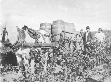
Photograph, Grape Picking in Great Western 1902
B/W photo of three men with a white horse pulling a cart with barrels of grapes just picked. Taken at Arrawatta Vineyard at Irvine's, Great western near Jonathon Gully and German Gully Roads. 1902win, wineries -
 Stawell Historical Society Inc
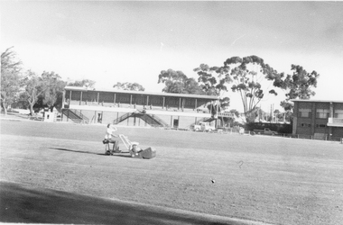
Photograph, Central Park Oval c 1980
c 1980 Parks and garden staff mowing Central Park Oval. No 2 Grandstand has its roof on. Also at the right end of the Grandstand is the Railway foot bridge which was demolished in 1991.. The Football Clubrooms built in mid 1960's is just in view on the right side. Photo of oval with garden staff mowing. No 2 Grandstand and just a section of the Football Clubhouse in view. c 1980'sstawell sports -
 Rutherglen Historical Society
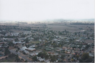
Photograph - Aerial Images, c2000
Colour aerial photograph of Rutherglen, viewed from the South West.Written on back of photo: "St Stevens lower left corner, State School just above | & Glenview, Silos mid left"rutherglen, st stephens church, saint stephens church, rutherglen winebottle, glenview nursing home, rutherglen state school -
 Rutherglen Historical Society
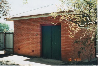
Image, 10/04/2003
Colour photograph of the Mortuary in Church Street, just prior to demolitionWritten on back of photo: "Mortuary, Church St, Rutherglen" At bottom right on photo: "10 4 '03"mortuary, buildings, church street -
 Rutherglen Historical Society
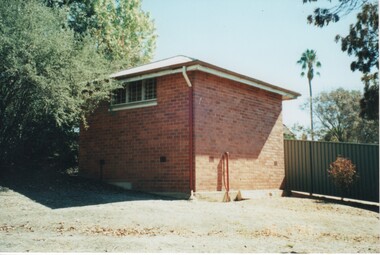
Photograph - Image, 10/04/2003
Colour photograph of the Mortuary in Church Street, just prior to demolitionWritten on back of photo: "Mortuary, Church St, Rutherglen" mortuary, buildings, church street -
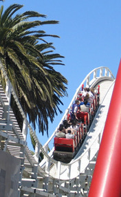 Ballarat Heritage Services
Digital Photograph Luna Park rollercoaster, Lisa Gervasoni, Luna Park rollercoaster St Kilda, early 2000s
Digital Photograph of a rollercoaster at Luna Park, St Kilda.luna park, rollercoaster, roller coaster, theme park, amusement, just for fun -
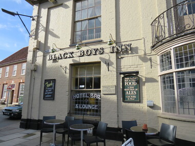 Ballarat Heritage Services
digital photographs, Inn, Aylesham, England, 2016
Black Boys Inn is in the market square of Aylesham, England. "Archaeological evidence shows that the site of the town has been occupied since prehistoric times. Aylsham is just over two miles (3 km) from a substantial Roman settlement at Brampton, linked to Venta Icenorum at Caistor St Edmund, south of Norwich, by a Roman road which can still be traced in places - that site was a bustling industrial centre with maritime links to the rest of the empire. Excavations in the 1970s provided evidence of several kilns, showing that this was an industrial centre, pottery and metal items being the main items manufactured. Aylsham is thought to have been founded around 500 AD by an Anglo Saxon thegn called Aegel, Aegel's Ham, meaning "Aegel's settlement". The town is mentioned in the Domesday Book of 1086 as Elesham and Ailesham, with a population of about 1,000. Until the 15th century, the linen and worsted industry was important here, as well as in North Walsham and Worstead and Aylsham webb or 'cloth of Aylsham' was supplied to the royal palaces of Edward II and III. John of Gaunt was lord of the manor from 1372 and Aylsham became the principal town of the Duchy of Lancaster. Although John of Gaunt probably never came to Aylsham, the townspeople enjoyed many privileges, including exemption from jury service outside the manor and from payment of certain taxes. The village sign depicts John of Gaunt. In 1519 Henry VIII granted a market on Saturdays and an annual fair to be held on 12 March, which was the eve of the feast of St Gregory the pope. Aylsham markets have always been an important feature of the town, and businesses developed to meet the needs of the town and the farming lands around it. Besides weekly markets there were cattle fairs twice a year and, in October, a hiring fair. The historic Black Boys Inn in the Market Place is one of Aylsham's oldest surviving buildings, and has been on the site since the 1650s, although the present frontage dates to between 1710 and 1720. There is a frieze of small black boys on the cornice and a good staircase and assembly room. The Black Boys was a stop for the post coach from Norwich to Cromer, had stabling for 40 horses, and employed three ostlers and four postboys. A thatched waterpump was built in 1911 at Carr's Corner in memory of John Soame by his uncle, a wealthy financier. An artesian well 170 feet (52 m) deep, its canopy is thatched in Norfolk reed. As with many of the other market towns in the county, the weaving of local cloth brought prosperity to the town in medieval times. Until the 15th century it was the manufacture of linen which was the more important, and Aylsham linens and Aylsham canvases were nationally known. From the 16th century linen manufacture declined and wool became more important, a situation that continued until the coming of the Industrial Revolution. Thereafter the principal trade of the town for the 19th century was grain and timber, together with the range of trades to be found in a town which supported local agriculture. Records show that Aylsham had markets and fairs, certainly from the 13th century. Such weekly and annual events were important for the trade that they brought. Annual horse fairs would bring many other traders to the town, and the weekly market would be the occasion for more local trade. The rights of the stallholders in the market place today date back to the rights established in medieval times." See wikipediaDigital photograph colouredinn, aylsham, england, black boys inn, market square -
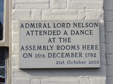 Ballarat Heritage Services
Photograph - Digital photograph, Lord Nelson Plaque, 2016
Black Boys Inn is in the market square of Aylsham, England. "Archaeological evidence shows that the site of the town has been occupied since prehistoric times. Aylsham is just over two miles (3 km) from a substantial Roman settlement at Brampton, linked to Venta Icenorum at Caistor St Edmund, south of Norwich, by a Roman road which can still be traced in places - that site was a bustling industrial centre with maritime links to the rest of the empire. Excavations in the 1970s provided evidence of several kilns, showing that this was an industrial centre, pottery and metal items being the main items manufactured. Aylsham is thought to have been founded around 500 AD by an Anglo Saxon thegn called Aegel, Aegel's Ham, meaning "Aegel's settlement". The town is mentioned in the Domesday Book of 1086 as Elesham and Ailesham, with a population of about 1,000. Until the 15th century, the linen and worsted industry was important here, as well as in North Walsham and Worstead and Aylsham webb or 'cloth of Aylsham' was supplied to the royal palaces of Edward II and III. John of Gaunt was lord of the manor from 1372 and Aylsham became the principal town of the Duchy of Lancaster. Although John of Gaunt probably never came to Aylsham, the townspeople enjoyed many privileges, including exemption from jury service outside the manor and from payment of certain taxes. The village sign depicts John of Gaunt. In 1519 Henry VIII granted a market on Saturdays and an annual fair to be held on 12 March, which was the eve of the feast of St Gregory the pope. Aylsham markets have always been an important feature of the town, and businesses developed to meet the needs of the town and the farming lands around it. Besides weekly markets there were cattle fairs twice a year and, in October, a hiring fair. The historic Black Boys Inn in the Market Place is one of Aylsham's oldest surviving buildings, and has been on the site since the 1650s, although the present frontage dates to between 1710 and 1720. There is a frieze of small black boys on the cornice and a good staircase and assembly room. The Black Boys was a stop for the post coach from Norwich to Cromer, had stabling for 40 horses, and employed three ostlers and four postboys. A thatched waterpump was built in 1911 at Carr's Corner in memory of John Soame by his uncle, a wealthy financier. An artesian well 170 feet (52 m) deep, its canopy is thatched in Norfolk reed. As with many of the other market towns in the county, the weaving of local cloth brought prosperity to the town in medieval times. Until the 15th century it was the manufacture of linen which was the more important, and Aylsham linens and Aylsham canvases were nationally known. From the 16th century linen manufacture declined and wool became more important, a situation that continued until the coming of the Industrial Revolution. Thereafter the principal trade of the town for the 19th century was grain and timber, together with the range of trades to be found in a town which supported local agriculture. Records show that Aylsham had markets and fairs, certainly from the 13th century. Such weekly and annual events were important for the trade that they brought. Annual horse fairs would bring many other traders to the town, and the weekly market would be the occasion for more local trade. The rights of the stallholders in the market place today date back to the rights established in medieval times." See wikipediaDigital photograph"Admiral Lord Nelson attended a dance at the Assembly rooms here on 15th December 1792 - 21st October 2005"aylsham, lord nelson, 1792, plaque -
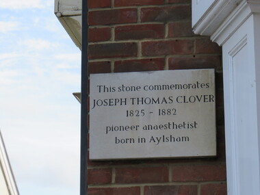 Ballarat Heritage Services
Photograph - Digital photograph, Dorothy Wickham, Plaque to Joseph Thomas Clover, ć2016
Lord Nelson plaque is in the town of Aylsham. "Archaeological evidence shows that the site of the town has been occupied since prehistoric times. Aylsham is just over two miles (3 km) from a substantial Roman settlement at Brampton, linked to Venta Icenorum at Caistor St Edmund, south of Norwich, by a Roman road which can still be traced in places - that site was a bustling industrial centre with maritime links to the rest of the empire. Excavations in the 1970s provided evidence of several kilns, showing that this was an industrial centre, pottery and metal items being the main items manufactured. Aylsham is thought to have been founded around 500 AD by an Anglo Saxon thegn called Aegel, Aegel's Ham, meaning "Aegel's settlement". The town is mentioned in the Domesday Book of 1086 as Elesham and Ailesham, with a population of about 1,000. Until the 15th century, the linen and worsted industry was important here, as well as in North Walsham and Worstead and Aylsham webb or 'cloth of Aylsham' was supplied to the royal palaces of Edward II and III. John of Gaunt was lord of the manor from 1372 and Aylsham became the principal town of the Duchy of Lancaster. Although John of Gaunt probably never came to Aylsham, the townspeople enjoyed many privileges, including exemption from jury service outside the manor and from payment of certain taxes. The village sign depicts John of Gaunt. In 1519 Henry VIII granted a market on Saturdays and an annual fair to be held on 12 March, which was the eve of the feast of St Gregory the pope. Aylsham markets have always been an important feature of the town, and businesses developed to meet the needs of the town and the farming lands around it. Besides weekly markets there were cattle fairs twice a year and, in October, a hiring fair. The historic Black Boys Inn in the Market Place is one of Aylsham's oldest surviving buildings, and has been on the site since the 1650s, although the present frontage dates to between 1710 and 1720. There is a frieze of small black boys on the cornice and a good staircase and assembly room. The Black Boys was a stop for the post coach from Norwich to Cromer, had stabling for 40 horses, and employed three ostlers and four postboys. A thatched waterpump was built in 1911 at Carr's Corner in memory of John Soame by his uncle, a wealthy financier. An artesian well 170 feet (52 m) deep, its canopy is thatched in Norfolk reed. As with many of the other market towns in the county, the weaving of local cloth brought prosperity to the town in medieval times. Until the 15th century it was the manufacture of linen which was the more important, and Aylsham linens and Aylsham canvases were nationally known. From the 16th century linen manufacture declined and wool became more important, a situation that continued until the coming of the Industrial Revolution. Thereafter the principal trade of the town for the 19th century was grain and timber, together with the range of trades to be found in a town which supported local agriculture. Records show that Aylsham had markets and fairs, certainly from the 13th century. Such weekly and annual events were important for the trade that they brought. Annual horse fairs would bring many other traders to the town, and the weekly market would be the occasion for more local trade. The rights of the stallholders in the market place today date back to the rights established in medieval times." See wikipediaDigital photograph"This stone commemorates JOSEPH THOMAS CLOVER 1825-1882 pioneer anaesthetist born in Aylsham"aylsham, joseph thomas clover, anaesthetist -
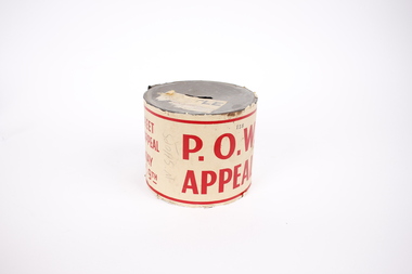 Dandenong/Cranbourne RSL Sub Branch
Memorabilia - Raffle tin, POW APPEAL, November 1945
NilHistory involved from just after WW11 for collection of funds for P.O.W's who had just returned form the conflict.P.O.W. Appeal raffle tin, street day appeal with white paper around with red writing, Silver tin compete with handle.Number 158 printed on paper. P.O.W. APPEAL printed on paper in red with address Room 11 7th Floor 340 Lt. Collins St. -
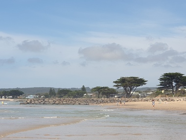 Ballarat Heritage Services
Photograph, Clare Gervasoni, Apollo Bay, Victoria, 24/01/2022
In 2021, the Department of Environment, Land, Water and Planning (DELWP) constructed two new groynes and a section of rock seawall at Apollo Bay to help manage the impacts of coastal erosion. The new 70-meter-long rock groynes run perpendicular to the shoreline and be located just south of the Milford St revetment and to the south of Milford Creek. Sections of rock seawall will be constructed between the two Groynes with an aim to protect the dune, walking path, cypress trees and road from erosion. Colour photograph of a coastal scene at Apollo Bay, featuring new rock groynes to protect the Great Ocean Road from erosion. apollo bay, beach, coast, groyne, rockwall -
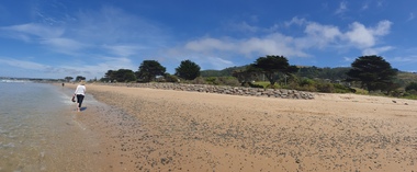 Ballarat Heritage Services
Photograph, Clare Gervasoni, Apollo Bay, Victoria, 24/01/2022
In 2021, the Department of Environment, Land, Water and Planning (DELWP) constructed two new groynes and a section of rock seawall at Apollo Bay to help manage the impacts of coastal erosion. The new 70-meter-long rock groynes run perpendicular to the shoreline and be located just south of the Milford St revetment and to the south of Milford Creek. Sections of rock seawall will be constructed between the two Groynes with an aim to protect the dune, walking path, cypress trees and road from erosion. Colour photograph of a coastal scene at Apollo Bay, featuring new rock wall and groynes to protect the Great Ocean Road from erosion. apollo bay, beach, coast, groyne, rockwall -
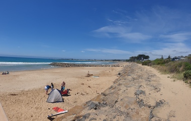
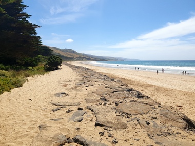 Ballarat Heritage Services
Photograph, Clare Gervasoni, Sea Wall at Apollo Bay, Victoria, 24/01/2022
In 2021, the Department of Environment, Land, Water and Planning (DELWP) constructed two new groynes and a section of rock seawall at Apollo Bay to help manage the impacts of coastal erosion. The new 70-meter-long rock groynes run perpendicular to the shoreline and be located just south of the Milford St revetment and to the south of Milford Creek. Sections of rock seawall will be constructed between the two Groynes with an aim to protect the dune, walking path, cypress trees and road from erosion. Colour photograph of a coastal scene at Apollo Bay, featuring new rock wall and groynes to protect the Great Ocean Road from erosion. apollo bay, beach, coast, groyne, rockwall, sea wall -
 Ballarat Heritage Services
Photograph, Clare Gervasoni, Sea Wall at Apollo Bay, Victoria, 24/01/2022
In 2021, the Department of Environment, Land, Water and Planning (DELWP) constructed two new groynes and a section of rock seawall at Apollo Bay to help manage the impacts of coastal erosion. The new 70-meter-long rock groynes run perpendicular to the shoreline and be located just south of the Milford St revetment and to the south of Milford Creek. Sections of rock seawall will be constructed between the two Groynes with an aim to protect the dune, walking path, cypress trees and road from erosion. Colour photograph of a coastal scene at Apollo Bay, featuring new rock wall and groynes to protect the Great Ocean Road from erosion. apollo bay, beach, coast, groyne, rockwall, sea wall