Showing 1378 items
matching state library victoria
-
 Bendigo Historical Society Inc.
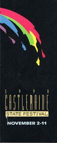
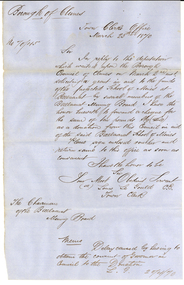
Document - CASTLEMAINE STATE FESTIVAL, CASTLEMAINE, 2 November 1990
... the Australian State Library of Victoria. The Festival...', Commissioned by the Latrobe Library, the Australian State Library... the Australian State Library of Victoria. The Festival Exhibition ...Castlemaine State Festival, Castlemaine. 2 November 1990. Programme. From the Chairmen - Mr Bereck Segan. Melbourne Committee: B R Segan, O.B.E. (Chairman), M Besen, A.O. (Deputy Chairman), Mrs H Dore (Hon. Sec.), C Anzarut, N Bourke, Ms M Coillet, Prof. C Duckworth, G Fairfax, A.M., K MacKenzie-Forbes, A.M., Mrs B Margetts, Dr F R Moulds, I.S.O., R Nordlinger, J Parker, M.B.E., A Porter, Ms M Prendergast, C Pyett, Ms D Reilly, Mrs, Ms L Schiftan, P M Schiftan, D Segan, B J Stewart, Ms S Walker, Dr R Wlikie. Melbourne Committee: I O'Halloran, (Chairman), Mrs M Rilen (Hon.Sec.), Miss R Wood (Treas), Mrs L Bennet, Mrs M Bock, S Cox, Cr T Daniell, Mrs H Griffiths, B Heydon, N Jennings, Mrs C McKellar, Miss M Oliver, L O'Toole, F Ransome-Smith, J Shortal, Dr D Silver, Mrs V Victor-Gordon, Mes E Warren, Miss L Waters. Welcome to the 1990 Castlemaine State Festival. As one festival closes, planning for the next commences immediately.. . Mr Ian O'Halloran, Chairman, Castlemaine. Castlemaine State Festival Administration, Festival Manager: Phee Broadway, Manager's Assistant: Mary Harris, Technical Manager: Lis Pain, Drawing Prize Co-ordinator: Bev Singleton, Farnham Concert Co-Ordinator: Noel Jennings with Victorian Rock Foundation. Event Listings: Opening by Hon. Jim Kennan M.P., Deputy Premier and Minister for the Arts Castlemaine Stadium. Melbourne Symphony Orchestra, Conductor - Hiroyuki Iwaki, Soloist - Dong -Suk Kang. Royal Variety Club Grand Final Theatre Royal, Town Crier Mr Neville Stonehouse. Kilmna Wildflower Walk. 'Melbourne: Architecture Today and the year 2000' Professor Peter McIntyre, A.O. Wine tasting. Selected Antique Fair. Organ Recital, organist Michael Bottomly. Mickleford Tour. A Closer Look at Castlemaine, Castlemaine Historical Society. 'Local Brew' Love Letters by A R Gurney, Starring Julia Blake and Terry Norris Directed by George Fairfax A.M. The Noel Watson Show. John Pringle and Miriam Gormley sing Operatic Gems with the Rantos Collegium and conductor Nicholas Braithwaite. The Incredible Shrinking Mortgage Show', Pat Wilson and Adrian Barnes. Festival Nightcap, Mr P P an acrobatic delight. Breakfast with Potts in the Park. A Stroll Around Town, Historical Society guide. Gardens Open. Selected Antique Fair. Festive Family Fun, musician Natasha Moszenin, Fratellini Brothers, Tim Hurley, Wally Fair Ground Organ, Foundry Band, Megan Jones, Mr P P. A guided Tour, Mrs Marjorie Rilen. Goetz Richter - Violin, Jeanett Carrigan - Piano. 'King Lear', Berenice Kavanagh and Suzanne Kersten. The Chagell Ensemble, Rita Reichman, Piano, Semmy Stalhammer, Violin. Trevor Jones, Viola. David Pereira, Cello. Steven Reeves, Double Bass. 'The Incredible Shrinking Mortagage Show' Pat Wilson and Adrian Barnes. Festival Hymns. 'Recital' Hellen Noonan, Douglas Horton, David Chesworth, Jacqui Everett, Jude Gunson. Music for Flute and Piano, Dereck Jones - Flute, Jeanell Carrigan - Piano. 'Brass With Class' William Evans - trumpet, David Farrend - trumpet, Russell Davis - french horn, Ken McClimont - trombone, Eric Klay - bass trombone. Piano Recital - Richard Mapp. Chris Ludwick's Society Synocopators - Cup Eve Cabaret, Chris Ludowyk - trombone, Peter Gaudion- Trumpet, Richard Miller - reeds, Pip Avent - tuba, Cal Duffy's - drums. 'Cup Eve Comedy' Rachel Berger and Richard Stubbs. Festival Nightcap Mr P P. Botanical Gardens Tour Kevin Walsh. Alice's Adventures in Wonderland Glenn Elston. By arrangement with Feipp and Park Projects and Elston, Hocking and Woods Pty Ltd. Family Concert, Piano for 4 hands Jocelyn Abbott and Richard Mapp, actor Justin Shortal. Cup Day Sports Carnival. Fashion Parade, luncheon available at Georgians in George Clark Place. The Melba Trio, Carolyn Hayes - Oboe, Jane Stacvy - cor anglais, Seng Tong - Oboe. 'Images' Prudence Davis - flute, Jeffrey Crellin - oboe, Peter Lynch - guitar. 'Sounds in Time' Andree Cozens - soprano, Berenice Kavanagh - words, Dudley - Simons - piano, John Snowden - Guitar, Peter Taylor - Set design & lighting. 'Music for Celestial Voices' Laurence - Jenkins - organ, Mary Anderson - harp, Margot Anderson - harp, Margot Cory - soprano. 'Proms for Preps' Nehama Patkin. Organ Recital Keeith Bottomley. Kaweka Walk, Kaweka Reserve Committee. 'Camille Claudel'. The Tudor Choristers Musical Director - John O'Donnell. 'Something for Everyone' Nehama Patkin - piano, guitar and voice, Peter Clinch - saxaphone and clarinet, major Australian Orchastras. 'The Dock Brief' & 'What Shall We Tell Caroline' Neville Stonehouse, Kay Barker, David Bickart, Angela Walter. 'Bluebeard' The Rag & Bone Theatre Company. Poedijono and the Javanese Gamelan, Poedijono (Teacher), musician, dancer and puppeteer. Botanical Gardens Tour, Kevin Walsh, horticulturist and garden writer. 'Music through the Ages' 'Pizzicato' - classical guitar ensemble, Castlemaine Courthouse, Bruce Millar, Meryl Wilkinson, Greg Wilkinson, Greg James, Joan Maher, Danny Silver. Bach and Vivaldi - Elysium Ensemble Greg Dikmans - Art Director, flute & recorder, Julie Hewison - violin, Lucinda Moon - violin, Janet Ferandez - viola, Miriam Morris - cello, Rosemanry Westbrook - double bass, John O'Donnell - harpsichord. 'Handle by Candle' Laurence Jenkins. Sarah Grunstein at the Piano, Sarah Grunstein. 'Let the Children Sing' Castlemaine Children's Choir, director Michael Bottomley, soloist Peter Bottomley. 'Made in Australia' Phillip Day, Bruce Waston, & 'Twankydillo'. The Dancers Company of the Australian Ballet, Les Sylphides, Dame Peggy van Praagh, Sir John Betjeman, Robert Ray. 'The Wooden Child' Handspan Theatre, Douglass Horton, Ken Evans, Andre Greenwell, Peter J Wilson, Philip Lethean. Botanic Gardens Tour Kevin Walsh. Divine Accidents and Heavenly Venues' William (Bill) Akers, A.M., Director of Productions, Australian Ballet. Jazz at the Jail. Another Stroll round Castlemaine, Historical Society. Muckleford Tour, Naturalists Club. 'Sketches' The Argus Guitar Quartet, Jochen Sxhubert, Tania Ravbar, Samantha Tout, Chi Ly.Scores for Instruments and Voices, Phylis Bachelor. Fred Shade, flute; Mara Miller, Violin; Len Vorster, piano; Loris Synan, soprano; and the students of the Faculty of Music, Melbourne University. Music for Four Hands at One Keyboard, Jocelyn Abbot and Richard Mapp. Paul Grabowsky and the Groovematics, Paul Graboesky, piano. Andrew Gander, Drums. Doug de Vries, guitar. Bob Venier, Trumpet, Flugelhorn. Ian Chaplin, saxophone. Garry Costello, double bass. Shelley Scown, vocals. 'My Most Loved Songs' David Bickart - Basso. Chapliapin, McEachern, Pinza, Robeson, Dawson. A Stroll Around Town, Historical Society. Breakfast at Buda. Garden Open. Festival Eucharist, choir and orchestra Directed by Kevin Bottomley. Music, Madness, Magic. Itchy Feet Pep Band, 'Sound Steppers', 'Legs on the Wall', Andrew Elliot, Antebodies. A Guided Tour of Angligan Parish Church. John Farnham in Concert, The Chain Reaction Tour. John Farnham. Exhibitions: Aspects of France: The Australian Artist's View. Artsits include John Russell, Lloyd Rees, David Davies, John Dent, Eric Wilson, E Phillips Fox, Ethal Carrick, Rupert Bunny, Max Meldrum, Will Ashton, George Bell and others. Annemieke Mein: Embroidery and Applique. Castlemaine Artists Incorporated 6th Biennial Exhibition. Dominique Segan Castlemaine State Festival Drawing Prize 1990. 'Provocative Pieces'. 'Feathered Friends' Barbara Muir. Through the Looking Glass. Handmade - For Pleasure, Julie Cook - dolls and puppets; Traude Beilharz - hats; Gwen Cook - embroidery; Erika Beilharz - woven pieces. 'High Art' students of Castlemaine. 'Works in Wood' Laurie Vella. Old Telegraph Station, Pioneers and Old Residents Association, Jubilee booklet on sale. Studio Exhibition, Juliana Hilton: Prints, paintings decorated screens and furniture. Val Restarick: Pottery and outdoor planters. 2nd Biennial Ernest Leviny Commemorative Silver Exhibition, leading contemporary silversmiths; Hendrick Foster, Tony Kean, Mike Wilson, Flynn Bros, Andrew Last, Mark Edgoose, Peter Gerter, Beatrice Schlabowsly, Marian Hoskings, Karyn Kirby, Chris Sherwin, Peter McBride, Fran Allison. Ray Stanyer - Ceramic Paintings. Norman Anderson - Water Colour Studies. 'Australian & Baroque' David Terry. 'Mediterranean Images' Val Restarick. Framing Shop, Brian Harding. Exhibition of Women Artists, Liz Caffin, Mary Quinlton, Debra Watkins, Lorraine Le Plastrier. Maine Images, Jacki Bickart, Valarie Blake, Sue Breeney, Kate Burtchell, Janet Chapman, Diana Davidson, Betty Hall, Deidre Hull, Molly Maddox, Norma McKenzie, Beth Oag, Rhyll Plant, Michell Phillipson, Diane Thompson. Ceramics, Ian Drumond. 'The Esplanade of Palms' (Brickworks Exhibition), John Wilkins. Han Built Pottery, George Butcher. Hollis Gallery, Richard Hollis, Kathy Hollis. 'End of an Era', Castlemaine Technical College Student Exhibition. 'Building A Country', Commissioned by the Latrobe Library, the Australian State Library of Victoria. The Festival Exhibition. 'Colour - Three Way's, Alice Clague, Geoffrey Clague, Howard Tozer. Tonal Oil Painters and Tapestry Exhibition by a group of local artists, Albert Pollard, Shirley Anderson, Valerie Blake, Ivy Brown, Marjorie Byrne, Janet Chapman, Frances Cree, Colleen Hall, Loretta Harris, Phyllis McClure, Lorraine McDowell, Norma McLean, Margaret Maher, Winsome Morrat, Jean Perry, Martha Phillips, Alison Ross, Norma Sneddon, Val Story, Irene Szabo, Jean Wells, and Alan Winzor. Roma Dodson.'BarleyTwist Cottage', Bill Davies, Linda Long, Fred Kuhnl. Photography Exhibition: Faces and Souls. Children's Books and Illustrations, Meet the authors and illustrators. Burnett Gallery and Garden, Drew Lawson, photographer of Eaglehawk. Decorated Cakes & Sugar Craft Exhibition, Barbara Porter. Sponsored by Marong Hotel. The Central Victorian Unique Design & Restoration Centre, historical photographs, sketches, etc. Badger's Keep Nursery & Mr Badger's Shop, Margaret Lees, Bill Jackson. Carriage Builders & Restorers. 'Harmonious Inspirations X Four' Kristina Browning, Catherine Tait, Rod Pitt, Lindy McAboy, Castle Mice by Sonia. Historic Cottage, 'Orvil Dean Stud', John and Anne Murdock, Judy Dean. The Heritage of Maldon, Geoffery Stocks. Stanyer's Pottery, Dragon Magic, Annett Annand, Ellan Hansa. 2(two) copies of this program.event, entertainment, castemaine state festival, castlemaine state festival, castlemaine 1990. programme. chairmen - mr bereck segan. committee:b r segan, o.b.e. (chairman), m besen, a.o. (deputy chairman), mrs h dore (hon. sec.), c anzarut, n bourke, ms m coillet, prof. c duckworth, g fairfax, a.m., k mackenzie-forbes, a.m., mrs b margetts, dr f r moulds, i.s.o., r nordlinger, j parker, m.b.e., a porter, ms m prendergast, c pyett, ms d reilly, mrs, ms l schiftan, p m schiftan, d segan, b j stewart, ms s walker, dr r wlikie. melbourne committee: i o'halloran, (chairman), mrs m rilen (hon.sec.), miss r wood (treas), mrs l bennet, mrs m bock, s cox, cr t daniell, mrs h griffiths, b heydon, n jennings, mrs c mckellar, miss m oliver, l o'toole, f ransome-smith, j shortal, dr d silver, mrs v victor-gordon, mes e warren, miss l waters. mr ian o'halloran, chairman, castlemaine. castlemaine state festival administration, festival manager: phee broadway, manager's assistant: mary harris, technical manager: lis pain, drawing prize co-ordinator: bev singleton, farnham concert co-ordinator: noel jennings with victorian rock foundation. event listings: opening by hon. jim kennan m.p., deputy premier and minister for the arts castlemaine stadium. melbourne symphony orchestra, condustor - hiroyuki iwaki, soloist - dong -suk kang. royal variety club grand final theatre royal, town crier mr neville stonehouse. kilmna 'melbourne: professor peter mcintyre, a.o. organist michael bottomly. mickleford tour. castlemaine historical society. love letters by a r gurney, starring julia blake terry norris directed by george fairfax a.m. the noel watson show.john pringle and miriam gormley operatic rantos collegium and conductor nicholas braithwaite. the incredible shrinking mortgage show', pat wilson and adrian barnes., mr p p an acrobatic delight. potts in the park. a stroll around town, historical society guide. selected antique fair. festive family fun, musician natasha moszenin, fratellini brothers, tim hurley, wally fair ground organ, foundry band, megan jones, . a guided tour, mrs marjorie rilen. goetz richter - violin, jeanell carrigan - piano. 'king lear', berenice kavanagh and suzanne kersten. the chagell ensemble, rita reichman, piano, semmy stalhammer, violin. trevor jones, viola. david pereira, cello.steven reeves, double bass. pat wilson and adrian barnes. festival hymns. 'recital' hellen noonan, douglas horton, david chesworth, jacqui everett, jude gunson. music for flute and piano, dereck jones - flute, jeanell carrigan - piano. 'brass with class' william evans - trumpet, david farrend - trumpet, russell davis - french horn, ken mcclimont - trombone, eric klay - bass trombone. piano recital - richard mapp. chris ludwick's society synocopators - cabaret, chris ludowyk - trombone, peter gaudion- trumpet, richard miller - reeds, pip avent - tuba, cal duffy's - drums. 'cup eve comedy' rachel berger and richard stubbs. festival nightcap mr p p. botanicla gardens tour kevin walsh. alice's adventures in wonderland glenn elston. by arrangemnent with feipp and park projects and elston, hocking and woods pty ltd. family concert, piano for 4 hands jocelyn abbott richard mapp, actor justin shortal. cup day sports carnival. fashion parade, lucheon available ar georgians in george clark place. the melba trio, carolyn hayes - oboe, jane stacvy - cor anglais, seng tong - oboe. 'images' prudence davis - flute, jeffrey crellin - oboe, peter lynch - guitar. 'sounds in time' andree cozens - soprano, berenice kavanagh - words, dudley - simons - piano, john snowden - guitar, peter taylor - set design & lighting. 'music for celestial voices' laurence - jenkins - organ, mary anderson - harp, margot anderson - harp, margot cory - soprano. 'proms for preps' nehama patkin. organ recital keeith bottomley. kaweka walk, kaweka reserve committee. 'camille claudel'. the tudor choristers musical director - john o'donnell. 'something for everyone' nehama patkin - piano, guitar and voice, peter clinch - saxophone and clarinet, major australian orchastras.'the dock brief' & 'what shall we tell caroline' neville stonehouse, kay barker, david bickart, angela walter. 'bluebeard' the rag & bone theatre company. poedijono and the javanese gamelan, poedijono (teacher), musician, dancer and puppeteer. botanical gardens tour, kevin walsh, horticulturist and garden writer. 'music through the ages' 'pizzicato' - classical guitar ensemble, courthouse, bruce millar, meryl wilkinson, greg wilkinson, greg james, joan maher, danny silver. bach and vivaldi - elysium ensemble greg dikmans - art director, flute & recorder, julie hewison - violin, lucinda moon - violin, janet ferandez - viola, miriam morris - cello, rosemanry westbrook - double bass, john o'donnell - harpsichord. 'handle by candle' laurence jenkins. sarah grunstein at the piano, sarah grunstein. 'let the children sing' castlemaine children's choir, director michael bottomley, soloist peter bottomley. 'made in australia' phillip day, bruce waston, & 'twankydillo'. the dancers company of the australian ballet, les sylphides, dame peggy van praagh, sir john betjeman, robert ray. 'the wooden child' handspan theatre, douglass horton, ken evans, andre greenwell, peter j wilson, philip lethlean. botanic gardens tour kevin walsh. divine accidents and heavenly venues' william (bill) akers, a.m., director of productions, australian ballet. jazz at the jail. stroll round castlemaine, historical society. muckleford tour, naturalists club. 'sketches' the argus guitar quartet, jochen sxhubert, tania ravbar, samantha tout, chi ly.scores for instruments and voices, phylis bachelor. fred shade, flute; mara miller, violin; len vorster, piano; loris synan, soprano; students of the faculty of music, melbourne university. music for four hands at one keyboard, jocelyn abbot and richard mapp. paul grabowsky and the groovematics, paul graboesky, piano. andrew gander, drums. doug de vries, guitar. bob venier, trumpet, flugelhorn. ian chaplin, saxophone. garry costello, double bass. shelley scown, vocals. 'my most loved songs' david bickart - basso. chapliapin, mceachern, pinza, robeson, dawson. stroll around town, historical society. breakfast at buda. garden open. festival eucharist, choir and orchestra directed by kevin bottomley. music, madness, magic. itchy feet pep band, 'sound steppers', 'legs on the wall', andrew elliot, antebodies. a guided tour of angligan parish church. john farnham in concert. exhibitions: aspects of france: the australian artist's view. artsits include john russell, lloyd rees, david davies, john dent, eric wilson, e phillips fox, ethal carrick, rupert bunny, max meldrum, will ashton, george bell and others. annemieke mein: embroidery and applique. castlemaine artists incorportated 6th biennieal exibition. dominique segan castlemaine state festival drawing prize 1990. 'provocative pieces'.'feathered friends' barbara muir. through the looking glass. handmade - for pleasure, julie cook - dolls and puppets; traude beilharz - hats; gwen cook - embroidery; erika beilharz - woven pieces. 'high art' students of castlemaine. 'works in wood' laurie vella. old telegraph station, pioneers and old residents association, jubilee booklet on sale. studio exhibition, juliana hilton: prints, paintings decorated screens and furniture. val restarick: pottery and outdoor planters. 2nd biennial ernest leviny commemorative silver exhibition, leading contemporary silversmiths; hendrick foster, tony kean, mike wilson, flynn bros, andrew last, mark edgoose, peter gerter, beatrice schlabowsly, marian hoskings, karyn kirby, chris sherwin, peter mcbride, fran allison. ray stanyer - ceramic paintings. norman anderson - water colour studies. 'australian & baroque' david terry. 'mediterranean images' val restarick. framing shop, brian harding. exhibition of women artists, liz caffin, mary quinlton, debra watkins, lorraine le plastrier. maine images, jacki bickart, valarie blake, sue breeney, kate burtchell, janet chapman, diana davidson, betty hall, deidre hull, molly maddox, norma mckenzie, beth oag, rhyll plant, michell phillipson, diane thompson. ceramics, ian drumond. 'the esplanade of palms' (brickworks exhibition), john wilkins.han built pottery, george butcher. hollis gallery, richard hollis, kathy hollis. 'end of an era', castlemaine technical college student exhibition. 'building a country', commissioned by the latrobe library, the australian state library of victoria. the festival exhibition. 'colour - three way's, alice clague, geoffery clague, howard tozer. tonal oil painters and taperstry exhibition by a group of local artists, albert pollard, shirley anderson, valerie blake, ivy brown, marjorie byrne, janet chapman, frances cree, colleen hall, loretta harris, phyllis mcclure, lorraine mcdowell, norma mclean, margaret maher, winsome morrat, jean perry, martha phillips, alison ross, norma sneddon, val story, irene szabo, jean wells, and alan winzor. roma dodson.'barleytwist cottage', bill davies, linda long, fred kuhnl. photogralhy exhibition: faces and souls. children's books and illustrations, meet the authors and illustrators. burnett gallery and garden, drew lawson, photographer of eaglehawk. decorated cakes & sugar craft exhibition, barbara porter. sponsored by marong hotel. the central victorian unique design & restoration centre, historical photographs, sketches, etc. badger's keep nursery & mr badger's shop, margaret lees, bill jackson. carriage builders & restorers. 'harmonious inspirations x four' kristina browning, catherine tait, rod pitt, lindy mcaboy, castle mice by sonia. historic cottage, 'orvil dean stud', john and anne murdock, judy dean. the heritage of maldon, geoffery stocks. stanyer's pottery, dragon magic, annett annand, ellan hansa. -
 Kilmore Historical Society
Photograph, Oriental Bank Corporation, 1866
... Library of Victoria. Double storey building with decorative... by State Library of Victoria Tenders called for erection... Copied by State Library of Victoria Tenders called for erection ...This photograph was most likely taken for the 1866 Intercolonial Exhibition in Melbourne.25cm x 20cm black and white reproduction of a photograph of the Oriental Bank Corporation, 7 Sydney Street Kilmore, from the State Library of Victoria. Double storey building with decorative parapet along roofline, wrought iron balconets at upper storey windows, decorative hood molds above windows, name of bank in stone under ground floor cornice, a man standing on path in front of bank. Woman standing at back of building in shadow. A sign on post at back of building reads: Land for Sale Apply to W. Grace Solicitor Kilmore.Printed on back: REPRODUCTION RIGHTS RESERVED Copied by State Library of Victoria Tenders called for erection of this building in March 1864.banks, 19th century -
 Federation University Historical Collection
Letter, Ballarat School of Mines Correspondence, 1895, 1895
... State Library of Victoria... College Geelong Technical School State Library of Victoria Library ...A number of letters clipped together with a brass split in. * Rock Specimen from J. Hornsby, Clunes * Bendigo School of Mines Letterhead from G. A. Thomas * J.A. Bickford, Daylesford * Geelong Technical College * Library of Victoria * Australian Museum Letterhead from S. Sinclair * University of Sydney Letterhead from H.L. Barff, Librarian * Library, Museum and Art Gallery of South Australia letterhead * Library, Museum and National Gallery and Victoria * Central Gold Mining Company by John Dunlop * SMB Students asking the Council to strenuously attempt to retain the services of Professor Krause ( Signed by about 70 students) * SMB staffmembers asking the Council to strenuously attempt to retain the services of Professor Krause ( Signed by Dawbarn, Dawson, Daniel Walker. W.E. Bennett, Kerr, Henry J. Hall) * Correspondence from Ferdinand Krause * Telegram from R.T. Vale * Queensland Museum letterhead * Stawell Technical College and School of Mines from W. Matthews j. hornsby, ballarat school of mines, letter card, j.a> bickford, daylesford, south central gold mining company, mining, geelong technical college, geelong technical school, state library of victoria, library of victoria, e.f. pittman, australian museum, alfred meller, e. whatman, university of sydney, richard benham, art gallery of south australia, national gallery of victoria, j.j. lanigan, ferdinand krause, j. flegeltaub, william reid, j.h. crittenden, james gibson, c.j. sayle, f.h. hollway, theo willaims, j. sutherland, p. flegeltaub, maurice hamburger, s. marrow, f. kittelty, a. don, a. bell, james a. gilchrist, j. ronaldson, e. stuck, w.j. whyte, ernest leggo, percy learmonth, kaboonga mining company, smeaton, g. alec thornsol, alex gilfillan, geologist, thomas j. hart, alfred hodgkinson, george t. clarke, a.w. pratt, walter fieder, w. macdonald, queensland museum, r.h. walcoth, stawell school of mines, stawell technical college, stephen richards, martin ford, b. herold, george w. gallagher, broomfield, j. money, smythesdale, john law, great western, mordaunt hall, eight hour procession, model locomotive, arthur kildahl, g. seymour, mt lyell, e.h. parry, d. grassy, aurora gold mining co, j. broomfield, burbury, dawburn, eustace m. weston, english and austrakuab copper co, martin gardiner, william little, david gracey -
Federation University Historical Collection
Letter, Inward Correspondence to the Ballarat School of Mines, 1910
... State Library of Victoria... Pitfield Plains Public Library State Library of Victoria letterhead ...pitfield, stawell, j. roberts, telegram, d.c. newham, mitta mitta, douglas brigetoche, dressmaking, ballarat technical art school, h.h. smith, consiston park snake valley, j.a. dawoon, a.h. walsh, pitfield plains, public library, state library of victoria, letterhead, e. lat. armstrong, g. elder, education department, h.l. langdon and co, the working men's college, robert aikins, macquarie steam brick yards, james dewar, mieklehouse, felton gramwade and co, a.b. humphrey, gordon, c. brennan, ballarat school of mines barkly street branch, l. eddy, sebastopol, w. brittain, west london scientific apparatus co, g. bell and sons -
Mission to Seafarers Victoria
Article - Survey, Bronwyn Hughes, The Art of Light: a survey of stained glass in Victoria, December 1990
... state library of victoria... in the chapel. la trobe journal state library of victoria bronwyn hughes ...Introduction Early Stained Glass in Victoria "Marvellous Melbourne" The Aftermath of the First World War Post-1945: Australian Modernism Conclusionnon-fictionIntroduction Early Stained Glass in Victoria "Marvellous Melbourne" The Aftermath of the First World War Post-1945: Australian Modernism Conclusionla trobe journal, state library of victoria, bronwyn hughes, stained glass window -
Glenelg Shire Council Cultural Collection
Book, The Catalogue of the Public Library of Victoria. Vol. II - P to Z and Addenda, 1880
... of Portland Borough Council archives reference state library catalogue ...Pale green paper binding covers, with title and author in black on spine and cover (within deceorative borders). 446 pp.archives, reference, state library, catalogue, victoria -
 Federation University Historical Collection
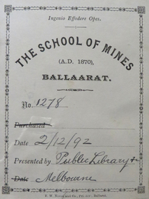
Book, John Ferres, Government Printer, Eucalyptographia : a Descriptive Atlas of the Eucalypts of Australia and Adjoining Islands, 1883-4, 1883 and 1884
... state library of victoria... library state library of victoria Two books (ninth and tenth ...Ferdinand Von Mueller was the Government Botanist for the Colony of Victoria. He was an early examiner in Botany at the Ballarat School of Mines. The book was donated to the Ballarat School of Mines by the Melbourne Public Library. The Bookplate in the front states the book is number 1278 in the Ballarat School of Mines Library and was presented on 02/12/1892.Two books (ninth and tenth decade) with soft cover and blue tape spine. Includes text and black and white images relating to Eucalypts .1) includes a bookplatebotany, ferdinand von mueller, ballarat school of mines, eucalypts, botanist, bookplate, melbourne public library, state library of victoria -
 Federation University Historical Collection
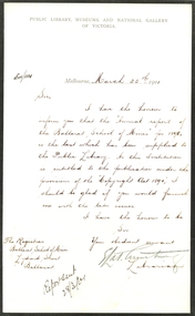
Correspondence, Letter on Letterhead from Public Library, Museums, and National Gallery of Victoria, 1901, 25/03/1901
... state library of victoria... of victoria letterhead armstrong state library of victoria copyright ...The black border recognised the death of Queen Victoria.Handwritten letter on letterhead Public Library, Museums, and National Gallery of Victoria which was bordered in black. The paper has been embossed with the crest of the library. The letter requests copies of the Ballarat School of Mines Annual Reports for the library.ballarat school of mines, melbourne public library, national gallery of victoria, letterhead, armstrong, state library of victoria, copyright act, legal deposit, crest, emboss -
Federation University Historical Collection
Book, Victoria Australia: Innovation Events Energy
... State Library of Victoria... Ground Olympic Park State Library of Victoria Great Ocean Road ...Blue hard covered book with dust jacket.holden, university of ballarat, smorgon steel, dennis family, melbourne water, tattersall's, east gippsland institute of tafe, gippsland water, multicultural victoria, murray goulburn co-operative, bendigo mining nl, mccain foods, melbourne docklands, mccain foods, melbourne cricket ground, olympic park, state library of victoria, great ocean road, lavendula, grampians, gippsland, bhp billiton -
 Federation University Historical Collection
Document, Establishment of the Ballarat School of Mines, 1870, 1870
... state library of victoria... state library of victoria fulks architecture reed j. reed ...The Ballarat School of Mines was the first site of technical edducation in Australasia. It is now a predecessor institution of Federation University Australia. It's first president was Redmond Barry.Correspondence and planning documents relating to the setting up of the Ballarat School of Mines. it includes tenders for contractors for the refurbishment of the former Ballarat Circuit Court. .1) Rules for the pupils of the Mining School at Zurickau, 18/11/1870 (not translated by Emanuel Steinfeld, perhaps by W. Henderson) .2) Regulations of the Mining Academy at Frieberg, 18/11/1870 .3) Einrichtungen, Freiberg, 1870 (written in German) .4) Letter from Somerville Learmonth of Ercildoun to Harrie Wood, Clerk of the Board of Mines Ballarat, accepting a position as one of three trustees of the Ballarat School of Mines, along with Redmond Barry and R.H. Bland, 08/01/1870 .5) Printing order with Robert Wreford, 26/01/1870 .6) H. Waymouth to Mr Bickett re the Ballarat School of Mines, 1780 .7) Letter from R.H. Bland of Clunes to Harrie Wood of the Ballarat Mining Board, 27/01/1870 .8) Letter from Somerville Livingstone Learmonth of Ercildoun to Harrie Woods of the Ballarat Mining Board refusing the offer to be a Trustee of the Ballarat School of Mines, 28/01/1870 .9) Minutes of the meeting of the Ballarat School of Mines Executive Council, 05/02/1870 and Correspondence from Harrie Wood to J. Warrington Rogers re the lease of the building for the Ballarat School of Mines, 21/01/1870 .10) Chief Secretary's Office to Ballarat Mining Board re Life Membership of the Ballarat School of Mines, 02/02/1870 .10b) Letter from Redmond Barry, Carlton Gardens, Melbourne re the visit of the Governor of Victoria to the Ballarat School of Mines, 04/02/1870 .12) Letter from Charles Pucke on behalf of Mr McCulloch to H, Ainswood, Secretary of the Ballarat Mining Board, 11/07/1870 .13) Correspondence from Henry Rosales of Walhalla (Chairman of the Gippsland Mining Board) to James Baker of the Ballarat School of Mines, 28/12/1870 .11) Meeting of the Executive Council, Bickett, Eddy Downes, 08/02/1870 .14) Letter from John Phillips, contract surveyor of St Arnaud to Mr Newman, Vice-President of the Ballarat School of Mines, 15/12/1870 .15) Articles ordered and obtained for the Ballarat School of Mines, 03/01/1870 .16) Telegram from John Lewis of Clunes to the Ballarat School of Mines. .16b) Quote from painter Thomas Robson for painting the Ballarat School of Mines, 05/06/1870 .17) Note from Duncan Gillies to Harrie Wood re grant for the Ballarat School of Mines, 05/06/1870 .18) Correspondence re Grant to the Ballarat School of Mines, Duncan Gillies, 04/07/1870 .19) Correspondence concerning the Ballarat School of Mines from F. Valient to Harrie Wood, 14/05/1870 .19b) Correspondence from Somerville Livingstone Learmonth to Harrie Woods - an apology for a meeting with Judge Rogers, 23/05/1870 .20) Letter from R.H. Bland to Harrie Wood, 15/07/1870 .22) Telegraph from J. Warrington Rogers to Harrie Wood of the Ballarat Mining Board concerning tenders for the Ballarat School of Mines, which was established in 1870. .23) Letter from Ballarat Mining Board to Judge Warrington Rogers, 31/05/1870 .24) Telegraph to Harrie Wood of the Ballarat Mining Board from J. Warrington Rogers concerning Sir Redmond Barry. A note at the bottom of the telegraph notes ‘This telegram has been delayed through repairs on line. .25) Letter on Melbourne Public Library Letterhead from librarian Augustus Fulk, 05/08/1870 .26) Letter from R.H. Bland to Harrie Wood, 30/05/1870 .27) Letter from Robert Park re alteration of the former Ballarat Court House for use as the Ballarat School of Mines, 05/05/1870. .28) Letter from G. Whitty re painting of the former Ballarat Court House for use as the Ballarat School of Mines, 04/05/1870 .29) Letter from William Newman re plastering of the former Ballarat Court House for use as the Ballarat School of Mines, 05/05/1870 .30) Letter from Charles A. Abbott re teaching Mechanical Drawing at the Ballarat School of Mines, 04/04/1870 .32) Letter from Redmond Barry to the Ballarat School of Mines, 07/1870 .31) National Insurance Company of Australia insurance for the Ballarat School of Mines (former Ballarat Circuit Court), 01/05/1870 .33) Letter from R.H. Bland to Harrie Wood, 09/1870 .34) Letter from Somerville Livingstone Learmonth to Harrie Wood, 06/09/1870 .35) Letter to the Chief Secretary to the Ballarat School of Mines Library & Museum, 30/11/1870 .36) Parliament house (Kitto) to the Ballarat Mining Board, 15/11/1870 .37) H. de la Poer Wall of Grenville College to R.W. Newman of the Ballarat School of Mines, 27/04/1971 .38) W.H. Odgers to the Ballarat East Town Clerk, 20/05/1870 .39) Correspondence to the Borough of Clunes for the Ballarat Mining Board requesting a grant to set of a school of mines at Ballarat. 25/03/1870 .40) Surveyor to Harrie Wood, Mining Registrar, 27/04/1870 .40) Letter to Judge Warrington Rogers re the contractor's account for satisfactory completion of work on the Ballarat School of Mines, 11/07/1870 .43) Desks for the Ballarat School of Mines by Henry Gough, 1870 .44) Ballarat Star Office to James Baker of the Ballarat School of Mines, 1870ballarat school of mines, frieberg mining academy, learmonth, somerville learmonth, wreford, weymouth, bland, rivet henry bland, barry, redmond barry, mcculloch, phillips, john phillips, robson, gillies, duncan gillies, warrington rogers, melbourne public library, whitty, robert park, newman, william newman, charles abbott, janes baler, de la poer wall, odgers, louis le gould, wood, harrie wood, steinfeld, emanuel steinfeld, ainswood, pucke, thomas robson, telegraph, telegram, state library of victoria, fulks, architecture, reed, j. reed, rosales, abbott, charles a. abbott, mechanical drawing, drawing, ballarat circuit courthouse, ballarat courthouse, national insurance company of australia, grenville college, chief secretary's office, robert sandon, school of mines, schools of mines, establishment, ballarat school of mines establishment, germany, london, ercildoun -
 Federation University Historical Collection
Book, The Old Pioneers' Memorial History of Melbourne From the Discovery of Port Phillip to the World War, 1924
... State Library of Victoria... Meolbourne City Mission State Library of Victoria Melbourne Public ...Blue hard covered book of 494 pages. Images, and a large plan of prominent burials in the Melbourne Old Cemetery, and a Map of Melbourne. melbourne, melbourne cemetery, melbourne old cemetery, john batman, edmund hobson, batman's map, st francis' church, james balfour, mrs hornbrook, paddy's market, wilson hall, working men's college, henry kendall, le souef's cottage, world war one, westernport, melbourne cup, hoddle, collingwood, south melbourne, prahran, richmond, kew, brunswick, coburg, preston, hawthorn, camberwell, nunawading, doncaster, st kilda, brighton, sandringham, cheltenham, caulfield, oalkleigh, footscray, sunshine, north melbourne, carlton, ballarat school of art library, ballarat technical art school, book plate, library plate, hume and hovell's overland journey 1824-5, major mtichell's overland journey, australia felix, booplate, aborigine, aboriginal, captain cook, arthur phillip, isaac smith, george bass, matthew flinders, john murray, catain baudain, captain collins, edward henty, portalnd, map od melbourne in 1938, john pascoe fawkner, the "enterprise: and fawkner's first home, old colonists' homes, rushall crescent north fitszroy, richard bourke, the old melbourne post offfice, old governmnt house, toorak, latrobe's house at jolimont, first melbourne land sale, melbourne water supply, peter henry smith, victorian legislative council opening, map of melbourne and collingwood, prince's bridge, crossing the rivers by punt, f.a> rucker, canvas city emerald hill, arrival of the gold escort in melbourne, the yarra, queen's wharf, tall ships, old st james, mary e. budd, st francis church, michael carr, meolbourne city mission, state library of victoria, melbourne public library, bourke street, angus mcmilan, methodist ladies college, ormond college, armistance celebrations, robert russell, mia mia, theatre royal bouke st, melbourne from flaggstaff hill, federal coffee palace collins st, lord melbourne, melbourne mint, old melbourne town hall, robert russell's melbourne and yarra falls, mandevalle hall, point lansdale lighthouse, wilson's promontory, margaret m. ward cole, williamstown, flinders st melbourne, queenscliff battery, broadmeadows soldiers' camp, embarkation of first troops on the 'ceramic', general monsash, ian hamilton, general bridges, victorian war memorial, national war memorial, st kilda pier, first melbourne cup, hoddle's grid, albert park, melbourne mechanic's institute, st kilda toll gate, munted policeman, springthorpe memorial, james bonwick, mornane's paddock, victorian railways melbourne and surburban lines, carlton gardens, thomas napier, wiliam westgarth, george augustus robinson, william lonsdale, elizabeth mary batman, peomena frances darling batman, dig tree, exhibition of 1854, exhibition of 1866, exhibition buildings, geelong harbour, jubilee lake, port campbell, warrnambool, queenscliff lightboat, batman's first house -
Federation University Historical Collection
Booklet, Bev Roberts, Beyond Words: The Book Through the Ages, c1994
... state library of Victoria... state library of Victoria john lewin john gould birds ...Soft covered booklet on rare books. Includes beautiful illustrations. books, state library of victoria, john lewin, john gould, birds, illumination, typography, johannes gutenberg, william caxton -
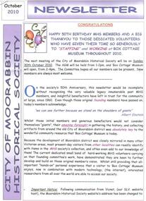 City of Moorabbin Historical Society (Operating the Box Cottage Museum)
Newsletter, City of Moorabbin Historical Society Oct 2010 jpg, pdf, October 2010
... state library of victoria... elster creek moorabbin shire box cottage museum state library ...The City of Moorabbin Historical Society was formed c 1960 by a group of Moorabbin residents who were concerned that the history of the area should be preserved. A good response to a call for items related to the historical area of Moorabbin Shire brought donations of a wide variety of artefacts which are now preserved by the current members of CMHS at Box Cottage Museum . Helen Stanley, Secretary of CMHS, began producing a Newsletter for members in April 2007 to provide current information and well researched items of historical interest. This Issue celebrates the 50th Anniversary of CMHS Helen Stanley has produced a bi-monthly Newsletter, 2007 - 2013, for the members of the City of Moorabbin Historical Society that contains well researched interesting historical items, notification of upcoming events, current advice from Royal Australian Historical Society , Museums Australia Victoria and activities of Local Historical Societies. The Newsletter is an important record of the activities of the CMHS and this month Celebrating the 50th Anniversary of CMHS.Issue 18 of the bi-monthly, City of Moorabbin Historical Society Newsletter produced by Society member and Secretary, Mrs Helen Stanley in October 2010. . Notice of AGM October 30th and Celebration of 50th Anniversary of CMHS. The Founding Members of CMHS are thanked and praised for their foresight, generosity of time and energy and for organising the collection of historical artefacts that created ‘Box Cottage Museum” as it is today. Mrs Dorothy Booth, FoMRGS, has donated her mother’s wedding dress to Box Cottage Museum, and John O’Callaghan, Glen Eira Historical Society, will donate a rebuilt computer. We are now commencing a Catalogue of our Library Books. The Story of the Elster Creek is attached.CITY of MOORABBIN HISTORICAL SOCIETY / OCTOBER 2010 NEWSLETTERcity of moorabbin historical society, stanley helen, booth dorothy, melbourne, moorabbin, brighton, cheltenham, ormond, bentleigh, market gardeners, pioneers, early settlers, elster creek, moorabbin shire, box cottage museum, state library of victoria, vicnet, city of moorabbin, box william, clothing, wedding dress, friends of mentone railway gardens, glen eira historical society, o’callaghan john -
 Bendigo Historical Society Inc.
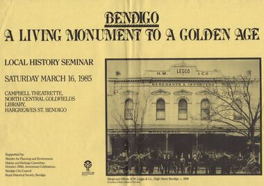
Document - DOCUMENT - FLYER FOR LOCAL HISTORY SEMINAR, 1985, BENDIGO
... State Library of Victoria... Bendigo H M Leggo & Co State Library of Victoria Bright yellow ...Bright yellow flyer of local history seminar, Saturday March 16, 1985 titled Bendigo - A Living Monument to a Golden Age, held at the Campbell Theatrette, North Central Goldfields Library, Hargreaves St. Bendigo. Has a copy of photo of Shops and Offices, H. M. Leggo & Co., High Street Bendigo. C. 1896. The photo shows a number of men outside H. M. Leggo & Co. Merchants & Importers, Wholesale Grocers. There are two horse drawn vehicles with two horses in each and some of the men have bicycles.bendigo, history, city history, flyer for local history seminar bendigo, north central goldfields library, ministry for planning and environment, history and heritage committee, victoria's 150th. anniversary celebrations, bendigo citycouncil, royal historical society bendigo, h m leggo & co, state library of victoria -
 Whitehorse Historical Society Inc.
Article, State Library Picture Collection, 1/03/1998 12:00:00 AM
... state library of victoria... Mitcham melbourne jones shirley state library of victoria ...Article on comic postcardsArticle on comic postcards held in State LibraryArticle on comic postcardsjones, shirley, state library of victoria, postcards -
 Whitehorse Historical Society Inc.
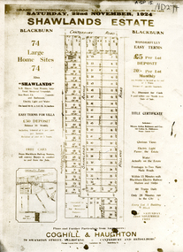
Document, Shawlands Estate, 22/11/1924 12:00:00 AM
... state library of victoria. latrobe library... haughton map collection state library of victoria. latrobe library ...Notice of Sale of land Holland Road and Canterbury RoadNotice of Sale of land Holland Road and Canterbury Road Blackburn Original in Haughton Maps LaTrobe LibraryNotice of Sale of land Holland Road and Canterbury Road land subdivision, canterbury road, blackburn south, holland road, shawlands avenue, coghill & haughton, shawlands estate, haughton map collection, state library of victoria. latrobe library -
Whitehorse Historical Society Inc.
Document, McGlone's Estate Mitcham, 1/04/1921 12:00:00 AM
... State Library of Victoria. LaTrobe Library... Station Haughton Map Collection State Library of Victoria. LaTrobe ...Copy of pamphlet of McGlone's Estate, Mitcham auctioned April 1921.Copy of pamphlet of McGlone's Estate, Mitcham auctioned April 1921. 24 allotments. Bordered by Whitehorse Road, McGlone Street, Station Street and Mitcham railway line and station. Original in Haughton maps, LaTrobe Library.Copy of pamphlet of McGlone's Estate, Mitcham auctioned April 1921. land sales, auctions, mcglone, john, mcglone, elizabeth, whitehorse road, mitcham, mcglone street, mitcham, station street, mitcham, mitcham railway station, haughton map collection, state library of victoria. latrobe library -
Whitehorse Historical Society Inc.
Document, Address by State Librarian, 7/10/1986 12:00:00 AM
... state library of victoria... Mitcham melbourne la scala jane state library of victoria public ...Address by Jane La Scala, State Librarian to MAV forum on Strategies for Local Authority Libraries.Address by Jane La Scala, State Librarian to MAV forum on Strategies for Local Authority Libraries.Address by Jane La Scala, State Librarian to MAV forum on Strategies for Local Authority Libraries.la scala, jane, state library of victoria, public libraries, municipal association of victoria -
Whitehorse Historical Society Inc.
Document, The Impact of fees in public libraries : the overseas experience, 3/10/1986 12:00:00 AM
... state library of victoria.... Mitcham melbourne public libraries public library funding state ...Supplement to earlier report to the Working Group on Public Library Funding.Supplement to earlier report to the Working Group on Public Library Funding.Supplement to earlier report to the Working Group on Public Library Funding.public libraries, public library funding, state library of victoria. -
 Bendigo Historical Society Inc.
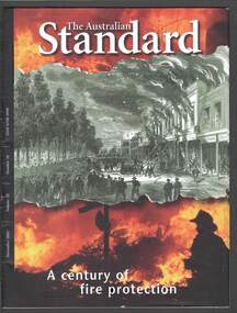
Magazine - THE AUSTRALIAN STANDARD NOVEMBER 2002 VOL 23 NO 10
... State Library of Victoria... Hope Kirkby La Trobe Picture Collection State Library ...Magazine titled 'The Australian Standard'. Dated November 2002 Volume 23 Number 10. Contains new and revised Australian Standards, publications and projects. Front cover has a part sketch of the Beehive Building, home of the Bendigo Stock Exchange, in Sandhurst (now Bendigo). Above and below the sketch is a part coloured picture of a fireman at a fire. An article mentions that on 25 August 1871, 18 year old Edward Hope Kirkby, watched the burning of the Beehive Building, home of the Bendigo Stock Exchange, this may have been his motivation to become one of the most prolific inventors of communication apparatus and fire protection equipment in Australia. Has a small full picture of the Burning of the Beehive Stores and Chambers, Sandhurst and picture of the E H kirkby Fire Alarm System.magazine, organization, standards australia, the australian standard november 2002 volume 23 number 10, felicity pontoni, tom godfrey, mark elder, pmp print, beehive building, bendigo stock exchange, edward hope kirkby, la trobe picture collection, state library of victoria, barry lee oam, brian kirkby, david michel -
 Bendigo Historical Society Inc.
Document - WHITE HILLS BOTANIC GARDENS, BENDIGO: HERITAGE SIGNIFICANCE ASSESSMENT AND STRATEGY PROJECT
... State Library of Victoria... Bendigo Library Vivien Newton Rita Hull State Library of Victoria ...Four hundred and forty three page report titled 'White Hills Botanic Gardens, Bendigo - Heritage Significance Assessment and Strategy Project by Lee Andrews & Associates Heritage Consulting, dated 31 October 2006. Contains History of White Hills Botanic Gardens, Physical Survey ad Analysis, Comparative Analysis, Analysis and Assessment of Cultural Significance, Developing the Conservation Policy, Conservation Policy, Conservation Guidelines, Conservation Actions,References and Appendices. Also contains a number of photos, copies of plans and documents, and a plan of the area with the trees marked and identified.document, white hills botanic gardens bendigo - heritage significance assessment and strategy project, bendigo historical society, jim evans, tim buykx, greater bendigo city council, lee andrews & associates heritage consulting, bendigo advertiser, the bendigonian, bendigo independent, argus, bendigo homes and property, mal gregory, mitch kemp, anthony sheean, casey ely, vicki johnson, sandra crump, friends of bendigo's botanic gardens, jane cleary, judy milner, jan orr, heritage victoria, john hawker, department of sustainability and environment historic places, norm stimson, bill dundas, janette hodgson, royal botanic gardens melbourne, roger spencer, university of melbourne burnley campus, greg moore, goldfields research centre, bendigo library, vivien newton, rita hull, state library of victoria, matheson library monash university, mueller correspondence project, sara maroske, library of the royal botanic gardens melbourne jill thurlow, helen cohn, gwen pascoe, john dwyer, larritt and russell -
Broadmeadows Historical Society & Museum
Magazine - Exhibition Catalogue, Trespassers and Intruders, 1982
... State Library of Victoria... State Library of Victoria Exhibition 1982 John Helder Wedge ...Magazine with articles of historical interestnon-fictionMagazine with articles of historical interestport phillip association, state library of victoria, exhibition, 1982, john helder wedge, michael connolly, john batman, charles swanston, joseph tice gellibrand, george mercer, william buckley -
 Bendigo Historical Society Inc.
Document - THE WILLIAM PATTON Burke and Wills EXPEDITION MAY 4 - 19 1991
... State Library of Victoria... Expedition Lt Col van den Tol State Library of Victoria Land ...Typed notes on an expedition by Army personnel and Richard Zakrzewski to find the grave of William Patton who was buried near the edge of the Bulloo River Overflow east of Tibooburra. He was a member of the Burke and Wills Party. Notes mention planning for the expedition and what they did while they were there. C. E. Burgess WO2, the author of the notes.document, the william patton expedition may 4 - 19 1991, the victoria exploring expedition of the exploration committee of the royal society of victoria, robert o'hara burke, william john wills, ludwig becker, william purcell, charles stone, charles gray, william patton, richard zakrzewski, army survey regiment, burke and wills expedition, lt col van den tol, state library of victoria, land information centre bathurst, capt. coulthard, wo1 slater, wo2 burgess, sgt de grauw, lcpl blake, capt cuskelly, wo1 gillies, ssgt sustart, cpl colde, cpl south, lcpl northausen, spr linwood, wo2 graham, ssgt gowers, sgt marshall, cpl doyle, cfn ellis, spr reynolds, spr hilbig, pte mckersie, 10/27 rsar, clifton downs homestead, gwen smith, william patton memorial -
Canterbury History Group
Article - Obituary Patricia Reynolds, Dianne Reilly, March 2015
... State Library of Victoria...Librarians Professionals State Library of Victoria Ian ...Obituary for Patricia Reynolds2 A5 photocopied pagesnon-fictionObituary for Patricia Reynoldslibrarians, professionals, state library of victoria, ian potter -
Port Melbourne Historical & Preservation Society
Postcard - Town Pier, Port Melbourne, 01: A H Harvey, .02: A C Green, 1890 - 1945
... by A C Green and part of the State Library Victoria Collection... photographs taken by A C Green and part of the State Library Victoria ...Purchased on E Bay March 2016Two photographic postcards purchased on Ebay. .01 Town Pier from the Eastern Beach c1890-1900 .02 Wanganella Hospital Ship at Station Pier 31.12.1945 Both photographs taken by A C Green and part of the State Library Victoria Collectionpiers and wharves - town pier, piers and wharves - station pier, war - world war ii, wanganella, a c green, j h harvey -
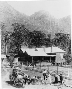 Halls Gap & Grampians Historical Society
Photograph - B/W, C 1880
... State Library Victoria, Rose's Australasian Views Victorian... Library Victoria, Rose's Australasian Views Victorian Series ...1880-1902 Land owned by Robert and Sarah Graham who owned a large portion of land best described as Upper Fyans Valley. At some time after 1880, they sold a parcel of the land under Sundial Peak to David Austin who built a slab hut. C1896, The land was sold to James and Amy Balmain which they named 'Bellfield' Amy was a daughter of John D/Alton who built the Stawell Water Supply System. Balmain purchased the vacant school cottage at Burnt Bridge and moved it to 'Bellfield' Over the next six years the house was enlarged to accommodate their growing family but sold in 1902 following the death of Amy Balmain.House with addition People leaving house by horse and carriage, people standing in groundsState Library Victoria, Rose's Australasian Views Victorian Series photographed and published by George Rose 123 Chapel St., Windsor, Victoriabuildings, houses, bellfield -
 Eltham District Historical Society Inc
Folder, Military camps in the Eltham area, 2008
... book, printout of photo from State Library Victoria and various... book, printout of photo from State Library Victoria and various ...Folder of information including a list of Military Camps in the Eltham area 1930-1940. Including photocopy of pages from unknown book, printout of photo from State Library Victoria and various copies of historial newspaper articles researched by Jim Allen in 2008HG Booklet 4harry gilham collection, military camps, eltham -
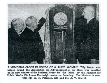 Vision Australia
Photograph - Image, W.H. Paterson, Sir James Kennedy and A.V. Worral, 27/3/1950
... Reproduction Rights Reserved Copied by State Library... Reserved Copied by State Library of Victoria 1 laminated image ...Newspaper article and image of unveiling of clock at the AAFB home in Brighton. Article reads: A Memorial Clock in Honour of a Blind Woman, Tilly Aston, who helped found the Association for the Advancement of the Blind, was unveiled at the new annexe of the Brighton Home for the Blind by the Minister for Public Works (Sir James Kennedy), centre, on Saturday. The Minister is seen with Mr W.H. Paterson, left, and Mr A.V. Worral.1 laminated image of newspaper articleReproduction Rights Reserved Copied by State Library of Victoriawilliam paterson, a.v. worral, sir james kennedy, association for the advancement of the blind, elanora home (brighton) -
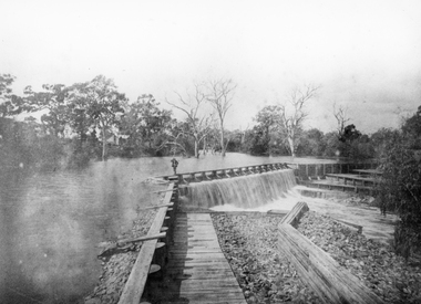 Stawell Historical Society Inc
Photograph, Wimmera River Weir at Glenorchy
... Reproduction Rights Reserved Copied by State Library... Library of Victoria Black & white photograph of a weir across ...Wimmera River Weir Glenorchy. Part of Wimmera Mallee Irrigation SystemBlack & white photograph of a weir across a river. Construction of weir is log & wood with a person walking along the weir. Trees in the background.Reproduction Rights Reserved Copied by State Library of Victoriawater -
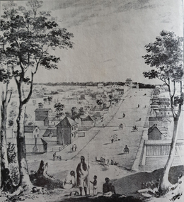 Ballarat Heritage Services
Photograph - Image, Collins Street, Melbourne in 1840, 1840
... . From the State Library of Victoria's Pictures Collection. .... From the State Library of Victoria's Pictures Collection ...Image of Collins Street Melbourne in 1840, looking west towards Russell Street, from a drawing by Elisha Noyce and William Knight, August 1840. The original worko is held by the State Library of Victoria. A group of Aborigines stand in the foreground. From the State Library of Victoria's Pictures Collection. collins street melbourne, melbourne, aborigines