Showing 406 items matching "surrey avenue"
-
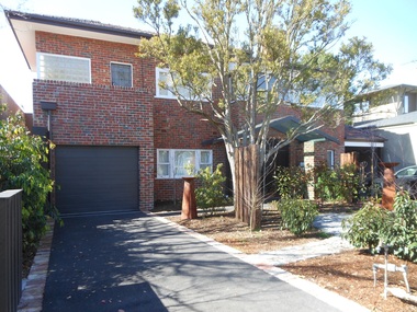
 Surrey Hills Historical Society Collection
Photograph - 12 Kinloch Avenue, Mont Albert, The Street Where You Live Project
Photos documenting this address as part of a photographic series undertaken by volunteer photographers during 2013 and 2014 for The Street Where You Live Project. This was organised through the Surrey Hills Neighbourhood Centre and covered the postcode 3127 in the cities of Boroondara and Whitehorse.These photos provide a snapshot of real estate in the suburbs of Mont Albert and Surrey Hills during a period of rapid change with many properties on large blocks demolished to create higher density residential development or renewal of single dwellings. At particular risk were properties not covered by heritage overlays, in particular interwar housing and post 1950's housing. -
 Kew Historical Society Inc
Plan - Subdivision Plan, Myrtle Park Estate, City of Camberwell, 1916
The Kew Historical Society collection includes almost 100 subdivision plans pertaining to suburbs of the City of Melbourne. Most of these are of Kew, Kew East or Studley Park, although a smaller number are plans of Camberwell, Deepdene, Balwyn and Hawthorn. It is believed that the majority of the plans were gifted to the Society by persons connected with the real estate firm - J. R. Mathers and McMillan, 136 Cotham Road, Kew. The Plans in the collection are rarely in pristine form, being working plans on which the agent would write notes and record lots sold and the prices of these. The subdivision plans are historically significant examples of the growth of urban Melbourne from the beginning of the 20th Century up until the 1980s. A number of the plans are double-sided and often include a photograph on the reverse. A number of the latter are by noted photographers such as J.E. Barnes.The ‘Myrtle Park Estate’ was a subdivision bounded by Victoria Road (now Lansdowne Street), Buchanan Avenue and Dight Avenue. Other streets that were created by the subdivision included Eurolie Street, Boorahman Street and Moody Street (now Sylvan Street). The Estate took its name from Myrtle Park (later changed to Macleay Park), which had been created in 1923 by Camberwell Council. The Park adjoined the southeast corner of the new subdivision. The Estate included 74 regular allotments characterised by narrow frontages and long blocks. Confusion may have greeted prospective purchasers as the Estate was advertised in the daily newspapers as being in East Kew, rather than in Camberwell, where it was at that stage located.subdivision plans - balwyn, myrtle park estate - camberwell [surrey hills] -
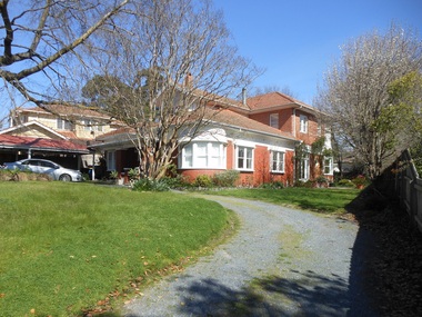
 Surrey Hills Historical Society Collection
Document - Plans, Andrew Wood, Building plans associated with Andrew Wood, builder of Surrey Hills, 1920s
These plans were associated with Mr Andrew Wood, a contract builder who worked in the 1920s and built many Californian bungalows in Surrey Hills and surrounding suburbs. Andrew Wood was born in Chiltern in 1861 to Andrew and Ellen Wood (MS: Green). His father had emigrated from Falkirk, Scotland. As a young man Andrew worked as a carpenter in the mines in South Africa (c 1899). He married Eleanor Agnes Stuchbery in Hamilton, Victoria in May 1901. They had 5 children - Doris (M Roberts), Robert Andrew, Donald Allen, Jean (M Cowan), and Gwenyth (M Bray). The first 2 children were born in Hawthorn; the other 3 in Surrey Hills. The family home at 286 Canterbury Road, Surrey Hills (on the corner of Middlesex Road) was built by Andrew. Andrew died in 1940; Eleanor died in 1977, aged 100 years. After Eleanor's death the house was sold and demolished. Surrey Lighting was established on the site. Gwenyth May Wood (3 May 1917, Surrey Hills - 5 Jan 2004) married Leslie David Charles Bray (1921-1983). Gwenyth was the donor's mother. Andrew, Eleanor and one son Robert are buried in Box Hill Cemetery - B-071-0028. .1: Specifications & plans for the kinder hall, Howard Street, Mont Albert for the Mont Albert Methodist Church, May 1925 .2 Plans for a proposed villa, 48 Payne's Paddock, Highfield Road, Canterbury for Mr E H Sillifant, dated 22/4/1920 .3 Plans for a timber villa for Mrs J A Burchell at Riversdale Road, Surrey Hills, stamped 9/5/1922 .4 Plan of a garage at Victoria avenue, Canterbury; stamped 14/2/1922 .5 Building permit & receipt from City of Hawthorn re Lot 16 Homebush Crescent; dated 7/4/1925 .6 Plans for a concrete house at Camberwell for Mr H W Field andrew wood, builders, box hill cemetery, kindergartens, mont albert methodist church, building plans, highfield road, ernest horatio sillifant, victoria avenue canterbury, lot 16 homebush crescent, californian bungalows, h w field -
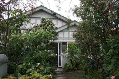
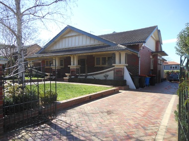
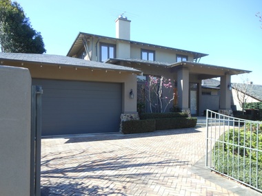
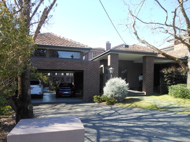
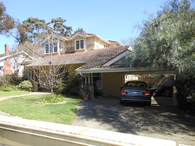
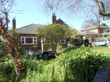
 Surrey Hills Historical Society Collection
Photograph - 1 Smythe Avenue, Mont Albert, On The Street Where You Live Project
Photos documenting this address as part of a photographic series undertaken by volunteer photographers during 2013 and 2014 for The Street Where You Live Project. This was organised through the Surrey Hills Neighbourhood Centre and covered the postcode 3127 in the cities of Boroondara and Whitehorse.These photos provide a snapshot of real estate in the suburbs of Mont Albert and Surrey Hills during a period of rapid change with many properties on large blocks demolished to create higher density residential development or renewal of single dwellings. At particular risk were properties not covered by heritage overlays, especially interwar housing and post 1950's housing. -
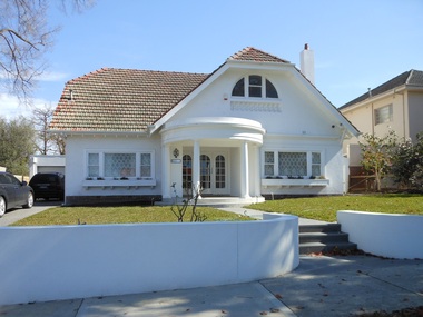
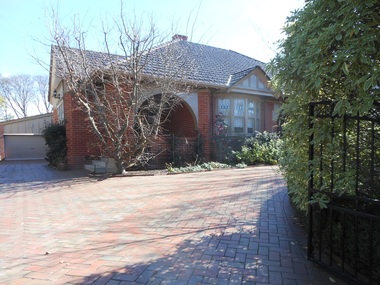
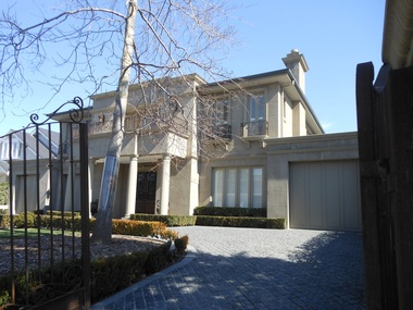
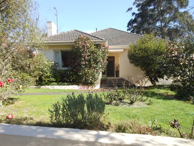
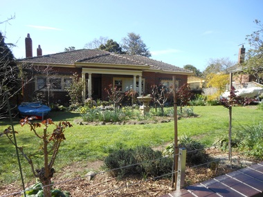
 Surrey Hills Historical Society Collection
Photograph - 2 Smythe Avenue, Mont Albert, On The Street Where You Live Project
Photos documenting this address as part of a photographic series undertaken by volunteer photographers during 2013 and 2014 for The Street Where You Live Project. This was organised through the Surrey Hills Neighbourhood Centre and covered the postcode 3127 in the cities of Boroondara and Whitehorse.These photos provide a snapshot of real estate in the suburbs of Mont Albert and Surrey Hills during a period of rapid change with many properties on large blocks demolished to create higher density residential development or renewal of single dwellings. At particular risk were properties not covered by heritage overlays, especially interwar housing and post 1950's housing. -
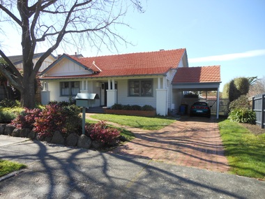
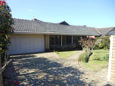
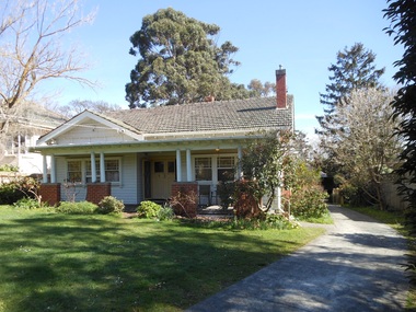
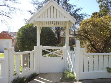
 Surrey Hills Historical Society Collection
Photograph - 3 Smythe Avenue, Mont Albert, On The Street Where You Live Project
Photos documenting this address as part of a photographic series undertaken by volunteer photographers during 2013 and 2014 for The Street Where You Live Project. This was organised through the Surrey Hills Neighbourhood Centre and covered the postcode 3127 in the cities of Boroondara and Whitehorse.These photos provide a snapshot of real estate in the suburbs of Mont Albert and Surrey Hills during a period of rapid change with many properties on large blocks demolished to create higher density residential development or renewal of single dwellings. At particular risk were properties not covered by heritage overlays, especially interwar housing and post 1950's housing. -
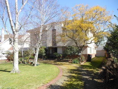
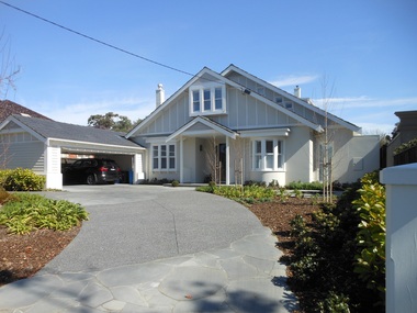
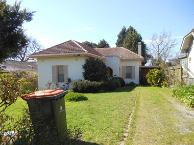
 Surrey Hills Historical Society Collection
Photograph - 4 Smythe Avenue, Mont Albert, On The Street Where You Live Project
Photos documenting this address as part of a photographic series undertaken by volunteer photographers during 2013 and 2014 for The Street Where You Live Project. This was organised through the Surrey Hills Neighbourhood Centre and covered the postcode 3127 in the cities of Boroondara and Whitehorse.These photos provide a snapshot of real estate in the suburbs of Mont Albert and Surrey Hills during a period of rapid change with many properties on large blocks demolished to create higher density residential development or renewal of single dwellings. At particular risk were properties not covered by heritage overlays, especially interwar housing and post 1950's housing. -
 Surrey Hills Historical Society Collection
Photograph - 5 Smythe Avenue, Mont Albert, On The Street Where You Live Project
Photos documenting this address as part of a photographic series undertaken by volunteer photographers during 2013 and 2014 for The Street Where You Live Project. This was organised through the Surrey Hills Neighbourhood Centre and covered the postcode 3127 in the cities of Boroondara and Whitehorse.These photos provide a snapshot of real estate in the suburbs of Mont Albert and Surrey Hills during a period of rapid change with many properties on large blocks demolished to create higher density residential development or renewal of single dwellings. At particular risk were properties not covered by heritage overlays, especially interwar housing and post 1950's housing. -
 Surrey Hills Historical Society Collection
Photograph - 6 Smythe Avenue, Mont Albert, On The Street Where You Live Project
Photos documenting this address as part of a photographic series undertaken by volunteer photographers during 2013 and 2014 for The Street Where You Live Project. This was organised through the Surrey Hills Neighbourhood Centre and covered the postcode 3127 in the cities of Boroondara and Whitehorse.These photos provide a snapshot of real estate in the suburbs of Mont Albert and Surrey Hills during a period of rapid change with many properties on large blocks demolished to create higher density residential development or renewal of single dwellings. At particular risk were properties not covered by heritage overlays, especially interwar housing and post 1950's housing. -
 Surrey Hills Historical Society Collection
Photograph - 7 Smythe Avenue, Mont Albert, On The Street Where You Live Project
Photos documenting this address as part of a photographic series undertaken by volunteer photographers during 2013 and 2014 for The Street Where You Live Project. This was organised through the Surrey Hills Neighbourhood Centre and covered the postcode 3127 in the cities of Boroondara and Whitehorse.These photos provide a snapshot of real estate in the suburbs of Mont Albert and Surrey Hills during a period of rapid change with many properties on large blocks demolished to create higher density residential development or renewal of single dwellings. At particular risk were properties not covered by heritage overlays, especially interwar housing and post 1950's housing. -
 Surrey Hills Historical Society Collection
Photograph - 8 Smythe Avenue, Mont Albert, On The Street Where You Live Project
Photos documenting this address as part of a photographic series undertaken by volunteer photographers during 2013 and 2014 for The Street Where You Live Project. This was organised through the Surrey Hills Neighbourhood Centre and covered the postcode 3127 in the cities of Boroondara and Whitehorse.These photos provide a snapshot of real estate in the suburbs of Mont Albert and Surrey Hills during a period of rapid change with many properties on large blocks demolished to create higher density residential development or renewal of single dwellings. At particular risk were properties not covered by heritage overlays, especially interwar housing and post 1950's housing. -
 Surrey Hills Historical Society Collection
Photograph - 9 Smythe Avenue, Mont Albert, On The Street Where You Live Project
Photos documenting this address as part of a photographic series undertaken by volunteer photographers during 2013 and 2014 for The Street Where You Live Project. This was organised through the Surrey Hills Neighbourhood Centre and covered the postcode 3127 in the cities of Boroondara and Whitehorse.These photos provide a snapshot of real estate in the suburbs of Mont Albert and Surrey Hills during a period of rapid change with many properties on large blocks demolished to create higher density residential development or renewal of single dwellings. At particular risk were properties not covered by heritage overlays, especially interwar housing and post 1950's housing. -
 Surrey Hills Historical Society Collection
Photograph - 10A Smythe Avenue, Mont Albert, On The Street Where You Live Project
Photos documenting this address as part of a photographic series undertaken by volunteer photographers during 2013 and 2014 for The Street Where You Live Project. This was organised through the Surrey Hills Neighbourhood Centre and covered the postcode 3127 in the cities of Boroondara and Whitehorse.These photos provide a snapshot of real estate in the suburbs of Mont Albert and Surrey Hills during a period of rapid change with many properties on large blocks demolished to create higher density residential development or renewal of single dwellings. At particular risk were properties not covered by heritage overlays, especially interwar housing and post 1950's housing. -
 Surrey Hills Historical Society Collection
Photograph - 11 Smythe Avenue, Mont Albert, On The Street Where You Live Project
Photos documenting this address as part of a photographic series undertaken by volunteer photographers during 2013 and 2014 for The Street Where You Live Project. This was organised through the Surrey Hills Neighbourhood Centre and covered the postcode 3127 in the cities of Boroondara and Whitehorse.These photos provide a snapshot of real estate in the suburbs of Mont Albert and Surrey Hills during a period of rapid change with many properties on large blocks demolished to create higher density residential development or renewal of single dwellings. At particular risk were properties not covered by heritage overlays, especially interwar housing and post 1950's housing. -
 Surrey Hills Historical Society Collection
Photograph - 12 Smythe Avenue, Mont Albert, On The Street Where You Live Project
Photos documenting this address as part of a photographic series undertaken by volunteer photographers during 2013 and 2014 for The Street Where You Live Project. This was organised through the Surrey Hills Neighbourhood Centre and covered the postcode 3127 in the cities of Boroondara and Whitehorse.These photos provide a snapshot of real estate in the suburbs of Mont Albert and Surrey Hills during a period of rapid change with many properties on large blocks demolished to create higher density residential development or renewal of single dwellings. At particular risk were properties not covered by heritage overlays, especially interwar housing and post 1950's housing. -
 Surrey Hills Historical Society Collection
Photograph - 13 Smythe Avenue, Mont Albert, On The Street Where You Live Project
Photos documenting this address as part of a photographic series undertaken by volunteer photographers during 2013 and 2014 for The Street Where You Live Project. This was organised through the Surrey Hills Neighbourhood Centre and covered the postcode 3127 in the cities of Boroondara and Whitehorse.These photos provide a snapshot of real estate in the suburbs of Mont Albert and Surrey Hills during a period of rapid change with many properties on large blocks demolished to create higher density residential development or renewal of single dwellings. At particular risk were properties not covered by heritage overlays, especially interwar housing and post 1950's housing. -
 Surrey Hills Historical Society Collection
Photograph - 14 Smythe Avenue, Mont Albert, On The Street Where You Live Project
Photos documenting this address as part of a photographic series undertaken by volunteer photographers during 2013 and 2014 for The Street Where You Live Project. This was organised through the Surrey Hills Neighbourhood Centre and covered the postcode 3127 in the cities of Boroondara and Whitehorse.These photos provide a snapshot of real estate in the suburbs of Mont Albert and Surrey Hills during a period of rapid change with many properties on large blocks demolished to create higher density residential development or renewal of single dwellings. At particular risk were properties not covered by heritage overlays, especially interwar housing and post 1950's housing. -
 Surrey Hills Historical Society Collection
Photograph - 15 Smythe Avenue, Mont Albert, On The Street Where You Live Project
Photos documenting this address as part of a photographic series undertaken by volunteer photographers during 2013 and 2014 for The Street Where You Live Project. This was organised through the Surrey Hills Neighbourhood Centre and covered the postcode 3127 in the cities of Boroondara and Whitehorse.These photos provide a snapshot of real estate in the suburbs of Mont Albert and Surrey Hills during a period of rapid change with many properties on large blocks demolished to create higher density residential development or renewal of single dwellings. At particular risk were properties not covered by heritage overlays, especially interwar housing and post 1950's housing. -
 Surrey Hills Historical Society Collection
Photograph - 16 Smythe Avenue, Mont Albert, On The Street Where You Live Project
Photos documenting this address as part of a photographic series undertaken by volunteer photographers during 2013 and 2014 for The Street Where You Live Project. This was organised through the Surrey Hills Neighbourhood Centre and covered the postcode 3127 in the cities of Boroondara and Whitehorse.These photos provide a snapshot of real estate in the suburbs of Mont Albert and Surrey Hills during a period of rapid change with many properties on large blocks demolished to create higher density residential development or renewal of single dwellings. At particular risk were properties not covered by heritage overlays, especially interwar housing and post 1950's housing. -
 Surrey Hills Historical Society Collection
Photograph - 17 Smythe Avenue, Mont Albert, On The Street Where You Live Project
Photos documenting this address as part of a photographic series undertaken by volunteer photographers during 2013 and 2014 for The Street Where You Live Project. This was organised through the Surrey Hills Neighbourhood Centre and covered the postcode 3127 in the cities of Boroondara and Whitehorse.These photos provide a snapshot of real estate in the suburbs of Mont Albert and Surrey Hills during a period of rapid change with many properties on large blocks demolished to create higher density residential development or renewal of single dwellings. At particular risk were properties not covered by heritage overlays, especially interwar housing and post 1950's housing. -
 Surrey Hills Historical Society Collection
Photograph - 19 Smythe Avenue, Mont Albert, On The Street Where You Live Project
Photos documenting this address as part of a photographic series undertaken by volunteer photographers during 2013 and 2014 for The Street Where You Live Project. This was organised through the Surrey Hills Neighbourhood Centre and covered the postcode 3127 in the cities of Boroondara and Whitehorse.These photos provide a snapshot of real estate in the suburbs of Mont Albert and Surrey Hills during a period of rapid change with many properties on large blocks demolished to create higher density residential development or renewal of single dwellings. At particular risk were properties not covered by heritage overlays, especially interwar housing and post 1950's housing. -
 Surrey Hills Historical Society Collection
Photograph - 20 Smythe Avenue, Mont Albert, On The Street Where You Live Project
Photos documenting this address as part of a photographic series undertaken by volunteer photographers during 2013 and 2014 for The Street Where You Live Project. This was organised through the Surrey Hills Neighbourhood Centre and covered the postcode 3127 in the cities of Boroondara and Whitehorse.These photos provide a snapshot of real estate in the suburbs of Mont Albert and Surrey Hills during a period of rapid change with many properties on large blocks demolished to create higher density residential development or renewal of single dwellings. At particular risk were properties not covered by heritage overlays, especially interwar housing and post 1950's housing. -
 Surrey Hills Historical Society Collection
Photograph - 21 Smythe Avenue, Mont Albert, On The Street Where You Live Project
Photos documenting this address as part of a photographic series undertaken by volunteer photographers during 2013 and 2014 for The Street Where You Live Project. This was organised through the Surrey Hills Neighbourhood Centre and covered the postcode 3127 in the cities of Boroondara and Whitehorse.These photos provide a snapshot of real estate in the suburbs of Mont Albert and Surrey Hills during a period of rapid change with many properties on large blocks demolished to create higher density residential development or renewal of single dwellings. At particular risk were properties not covered by heritage overlays, especially interwar housing and post 1950's housing. -
 Surrey Hills Historical Society Collection
Photograph - 22 Smythe Avenue, Mont Albert, On The Street Where You Live Project
Photos documenting this address as part of a photographic series undertaken by volunteer photographers during 2013 and 2014 for The Street Where You Live Project. This was organised through the Surrey Hills Neighbourhood Centre and covered the postcode 3127 in the cities of Boroondara and Whitehorse.These photos provide a snapshot of real estate in the suburbs of Mont Albert and Surrey Hills during a period of rapid change with many properties on large blocks demolished to create higher density residential development or renewal of single dwellings. At particular risk were properties not covered by heritage overlays, especially interwar housing and post 1950's housing. -
 Surrey Hills Historical Society Collection
Photograph - 24 Smythe Avenue, Mont Albert, On The Street Where You Live Project
Photos documenting this address as part of a photographic series undertaken by volunteer photographers during 2013 and 2014 for The Street Where You Live Project. This was organised through the Surrey Hills Neighbourhood Centre and covered the postcode 3127 in the cities of Boroondara and Whitehorse.These photos provide a snapshot of real estate in the suburbs of Mont Albert and Surrey Hills during a period of rapid change with many properties on large blocks demolished to create higher density residential development or renewal of single dwellings. At particular risk were properties not covered by heritage overlays, especially interwar housing and post 1950's housing. -
 Surrey Hills Historical Society Collection
Photograph - 26 Smythe Avenue, Mont Albert, On The Street Where You Live Project
Photos documenting this address as part of a photographic series undertaken by volunteer photographers during 2013 and 2014 for The Street Where You Live Project. This was organised through the Surrey Hills Neighbourhood Centre and covered the postcode 3127 in the cities of Boroondara and Whitehorse.These photos provide a snapshot of real estate in the suburbs of Mont Albert and Surrey Hills during a period of rapid change with many properties on large blocks demolished to create higher density residential development or renewal of single dwellings. At particular risk were properties not covered by heritage overlays, especially interwar housing and post 1950's housing. -
Surrey Hills Historical Society Collection
Map, Contour map of Surrey Hills showing potential sites for the Telecom Tower
The PMG / Telecom / Telstra tower was built in 1961-1963 as a relay station to support television and radio links between city and regional broadcasting stations. The tower itself was 45 m in height with a 2 storey building for equipment and staff surrounded by garden. From the beginning it was opposed by local residents. The location is said to be the second highest site in Melbourne, sometimes described as Delaney's Hill.Two A3 photocopied sheets of a map showing part of Surrey Hills, roughly between Windsor Crescent and Belmont Street (north / south) and Standard Avenue and Balmoral Crescent (east / west). The map shows contour lines and house sites, 16 of which are numbered. One sheet has been inscribed in top RH corner with notes regarding the significance of the numbers."Contour map of potential sites / for the telecommunications tower which / was eventually sited at 2. / Jock Campbell OBE was our neighbour / at 4 Theodore St when we moved into / the area in 1984. He was responsible in his / job at the PMG in deciding on the /site of the tower - Note site 5 was / behind his (& our) house. / Jack ended his career as Deputy Director / of the PMG. He sat on international committees / after WW2 to decide the split of the electronic / spectrum for radio, TV etc. / His group developed a "mobile phone" using / fixed towers but the phone was a truck full of gear."contour map, telecom tower, maps, jock campbell, john duncan campbell -
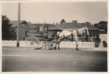 Surrey Hills Historical Society Collection
Photograph - M F Conlon bakery delivery cart, 1953, Victor Cattoni, 1953
This photo was taken by Victor Cattoni of Ingham in Queensland when he was in Melbourne on his honeymoon in 1953. The donor (his son) knew of no connection between his father and the Conlon family. Victor and his wife, Julia, travelled to Melbourne on the 'Mananda', which had been converted into a hospital ship in 1940. Victor was a motor mechanic and business man in Ingham and later a sugarcane farmer at nearby Abergowrie. Conlon's bread factory was located at 410-412 Canterbury Road on the corner of The Avenue. The site was purchased in 1927 by Michael Conlon and the factory built in 1928/1929. The original Conlon bakery was at 108 Union Road. This became to retail shop until the 1940s with the family involved in both the bakery and the shop. The photo is representative of the era when home deliveries by horse and cart were made by local traders including the baker, green grocer and dairy man. It also documents part of the history of a local business of longstanding.B&W photo of M F Conlon Surrey Bread Factory horse & cart at rest in a street in front of a picket fence.On the rear: "Photo by: / Victor Cattoni / Ingham, North Queensland / 1953" This is the same hand as that on the donation form, so it is presumed to have been added by Ed Cattoni prior to donation to SHHS. there are also photographic processing marks: "Ilford" stamped on the rear of the photographic paper and the number 71.victor cattoni, conlon's bread factory, 1953, canterbury road, factories, horse drawn deliveries, home deliveries -
 Surrey Hills Historical Society Collection
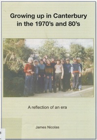
Book, Growing up in Canterbury in the 1970s and 80s:a reflection of an era, 2015
This is a recollection of what was one person's view on growing up in Willandra Avenue, Canterbury and the surrounding area.This is a recollection of what was one person's view on growing up in Willandra Avenue, Canterbury and the surrounding area.|20 pages(mr) james nicolas, childhood and youth, canterbury, willandra avenue, scouts, (mrs) betty ballantyne, (mr) - hawkens, (mrs) - hawkens, (mrs) - thomas, (mr) phillip anderson, kranjcics family, (mr) john proper, (dr) (mr) - barton, (mr) - phillips, (mr) - goff, (mrs) - mcmillan, (mr) - mceroy, (miss) caroline harris, (mr) - ielpo, (mr) graeme brent, (mr) peter brent, (mrs) tuyet brent, buckingham family, (mrs) - proper, billings family, howats family, canterbury football club, (mr) jim shepherd, (mrs) lillian shepherd, tulloch begg, house names, salvation army, (mr) (dr) alan williams, dentists, doctors, malone's hotel, canterbury mansions, (mr)(father) - potter, (mrs) - kerr, (mr) - kerr, canterbury cricket club, the gunyah, (mr) jim richards, (mr) "rainbow" simpson, canterbury football club, (mr)(cr) - maling, (sir) (mr) aaron danks, logan family, hasset family, staig family, (mr) tony petroro, outer circle, canterbury presbyterian church, bradshaw's mechanic, (mr) francis bourke, emulation hall, (mr) - cameron, (mr) - lathan, canterbury primary school, vozzo's milk bar, camberwell high school, (mr) - de munk, (mr) - howie, (miss) - patterson, (mr) - collins, (miss) kylie minogue, (mr) craig mcdonnell, (mr) dean mcdonnell, (miss) danni minogue, (mr) jack) morris, (mrs) marjorie rowe, (mr) andrew rowe, (mr) peter rowe, (mr) richard rowe, (mr) richard rowe, (mr) frank kelly, gagliardi family, (mr) phillip graham, mcdonnell family, sutherland family, toddle inn, rooney's butcher -
 Surrey Hills Historical Society Collection
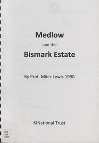
Book, Medlow and the Bismark Estate by Prof. Miles Lewis, 1990
... family medlow varzin avenue warrigal road surrey hills ...The Medlow Estate is a remarkable testimony to the unfulfilled expectations of the land boom of the 1880s to early 1890s. The areas of the former lot 14 or the lines of Varzin Avenue and Friedrichsruh Street where they pass through the present grounds will be conserved as may seem appropriate to exhibit the development of the garden in the Cairncross and Bull periods.The Medlow Estate is a remarkable testimony to the unfulfilled expectations of the land boom of the 1880s to early 1890s. The areas of the former lot 14 or the lines of Varzin Avenue and Friedrichsruh Street where they pass through the present grounds will be conserved as may seem appropriate to exhibit the development of the garden in the Cairncross and Bull periods.bismark estate, rosalie estate, conservation of natural resources, (mr) rex swanson, landform australia, cairncross family, medlow, varzin avenue, warrigal road, surrey hills, friedrichsruh street, (mr) (dr) r j bull, (miss) mary jane cairncross, g n taylor