Showing 4077 items matching "surveying-terrestrial"
-
 Bendigo Military Museum
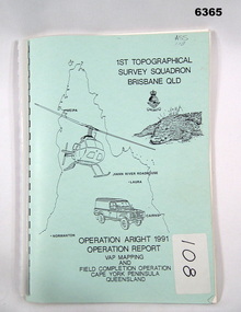
Administrative record - Royal Australian Survey Corps Report on Operation Aright 91 conducted by 1 Field Survey Squadron 1991, 1 Fd Svy Sqn, 7 Oct 1991
Royal Australian Survey Corps Operation Aright 91 (Field Completion) was a Field Verification and Vital Assets Protection (VAP) Mapping Operation conducted in Far North Queensland during the period 18 Jun - 29 Jul 1991 by 1 Fd Svy Sqn. The Operation covered the 1:250,000 Map area of SD54-16 Hann River and SE54-7 Normanton.Pale Blue cover with motifs of North Queensland, crocodile, RASvy Corps Badge, Army Helicopter and Land rover. Contains an A4 paper report of typed pages and diagrams secured by a plastic binder.Cover Hand annotated "ASS 108" (Air Survey Sqn, copy 108)royal australian survey corps, rasvy, fortuna, army survey regiment, army svy regt, asr -
 Bendigo Military Museum
Photograph - Royal Australian Survey Corps Surveyors in the Field – Project Cutlass, New Guinea, 1956 – 1957
... surveying ...This is a set of 23 photographs of surveyors and support staff in the field undertaking tasks in New Guinea 1956 – 1957. The surveyors were employed in the establishment of mapping and geodetic control for Project Cutlass, the “Ship-Shore” survey of the New Ireland province. In this survey operation surveyors used theodolites to observe horizontal and vertical angles and chains to measure base line distances between survey stations. Bob Skitch shown in photo .7P was in the 2nd year of his career in the Australian Army. He achieved the rank of Lieutenant-Colonel, and his last appointment was the CO of the Army Survey Regiment from 1976 to 1980.This is a set of 23 photographs of surveyors and support staff in the field undertaking duties during Project Cutlass located in New Ireland, New Guinea 1956 – 1957. The photographs were printed on photographic paper and are part of the Army Survey Regiment’s Collection. The photographs were scanned at 300 dpi. .1) - Photo, colour, 1956. Surveyors travelling main road from Kavieng to Namatanai, New Ireland. .2) - Photo, colour, 1956. Unidentified surveyors assessing recovery of their vehicle after bridge collapsed on west side of New Ireland. .3) - Photo, colour, 1956. Unidentified surveyors assessing recovery of their vehicle after bridge collapsed over flooded creek on west side of New Ireland. .4) - Photo, colour, 1956. Survey personnel L to R: Bev Uwins, John Lambie, Bob Thompson, New Ireland. .5) - Photo, colour, 1956. Survey base camp, New Ireland. .6) - Photo, black & white, 1956-1957. Geoff Helsham with possible human remains, New Ireland. .7) - Photo, black & white, 1956-1957. Bob Skitch undertaking survey observations using Wild T2 theodolite, New Ireland. .8) - Photo, black & white, 1956-1957. Chas Beach undertaking survey observations using Wild T2 theodolite, New Ireland. .9) & .10) - Photo, black & white, 1956-1957. Kev Parker (cook) New Ireland. .11) - Photo, colour, 1957. Brian Berkery taking a break, Top Manor Island, Lihir Island Group off New Ireland. Latitude -2° 46”, Longitude 152° 40”. .12) - Photo, colour, 1957. Survey base camp L to R: Chas Beach, Bev Uwins, Feni Islands, New Ireland. Latitude -4° 05”, Longitude 153° 45”. .13) - Photo, colour, 1957. A Hous Kiap. (Kiaps, known formally as district officers and patrol officers, were travelling representatives of the British and Australian governments), New Ireland. .14) & .15) - Photo, colour, 1957. L to R: Joe Farrington, Tom Royle Bob undertaking survey observations using theodolites from an improvised timber tower, New Ireland. .16) & .17) - Photo, colour, 1957. US Army ship FS216 used for ship-to-shore triangulation docked at Rabaul, New Britain. .18) - Photo, colour, 1957. US Army ship FS216 used for ship-to-shore triangulation docked at Kavieng, New Ireland. Sight target on top of mast. .19) - Photo, colour, 1957. Survey personnel onboard US Army ship FS392, L to R: Peter Frodsham, Bob Thompson, Doc Reid, John Underwood, remainder unidentified, New Ireland. .20) - Photo, colour, 1957. Survey base line party heading ashore, New Ireland. .21) - Photo, colour, 1957. Survey personnel rowing US Army assault boat L to R: Kev Parker, Chas Beach, folded up survey beacons overhanging stern, New Ireland. .22) - Photo, colour, 1957. Les Bailey onboard US Army ship departing Rabaul, New Britain for Brisbane. .23) - Photo, colour, 1957. Ron Newman onboard US Army ship departing Rabaul, New Britain for Brisbane. Active volcano in background..1P to .23P annotated on back – ‘Operation Cutlass’, personnel names, the year and the location. royal australian survey corps, rasvy, army survey regiment, fortuna, a, army svy regt, asr, surveying -
 Bendigo Military Museum
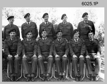
Photograph - Army Survey Regiment’s Officers, Warrant Officers and Sergeants and Squadrons, at Fortuna, Bendigo, 1982
This is a set of six staff photographs of the Army Survey Regiment’s Officers, Warrant Officers and Sergeants, and each of its four Squadrons at Fortuna, Bendigo in December 1982. Note - Air Survey Squadron’s photo was probably taken in July 1982 as they appear in winter dress. Air Survey Squadron was responsible for aerotriangulation, photogrammetric feature extraction and the AUTOMAP 1 system. Typical tasks were flight planning the acquisition of aerial photography, pugging, mensuration and block adjustments, photogrammetric extraction of topographic features from aerial photography, digital feature editing, map compilation, operating the scanner/plotter, operating the AUTOMAP 1 system and computer programming by civilians. Cartographic Squadron was responsible for the production of the following military products: Joint Operation Graphics, small-scale RAAF Air Charts, large-scale topographic line maps and orthophotomaps. Cartographic technician tasks were scribing, compiling, retouching, masking, type setting, type stickup, terrain embossing, correcting and proving quality control. Headquarters Squadron was responsible for the planning and coordination of map production and contracts. It also performed administrative and support functions such as personnel administration, pay, finance, transportation, records, map Library, kitchens, messes and facility maintenance. It was staffed by Army personnel from RASvy, RACT, AACC, RAAOC and RAEME corps. Other supporting staff at this time included the RAAF Liaison Officer, RAN Liaison Officer and several civilians employed in administration, the Q-Store and grounds maintenance. A component of the Army Svy Regt’s cartographic map production was carried out by the Detachment, a sub-unit located at Bonegilla next to the School of Military Survey. Lithographic Squadron was responsible for the reproduction of map materials and printing of military map products. The main tasks undertaken by photographic technicians were photographic enlargements, reductions and duplication of map reproduction material and processing of aerial photography. Printing technician tasks included platemaking, offset printing, map stock despatching and proofing.This is a set of six staff photographs of the Army Survey Regiment’s Officers, Warrant Officers and Sergeants, and its four Squadrons, at Fortuna, Bendigo, 1982. The black and white photographs were printed on photographic paper and are part of the Army Survey Regiment’s Collection. The photograph was scanned at 300 dpi. No personnel are identified. No personnel are identified. .1P – Annotated on front “OFFICERS MESS DEC ’82” .2P – Annotated on back “SGTS MESS DEC ’82” .4P– Annotated on front “CARTO SQN DEC ’82” .5P– Annotated on front “HQ SQN DEC ’82”royal australian survey corps, rasvy, army survey regiment, army svy regt, fortuna, asr, air survey, carto, litho -
 Lakes Entrance Historical Society
Book, Morrissey D W and Morrissey E W, Lakes Entrance a Short History and Tourist Guide
A short history of lakes Entrance from early settlement, including references to forest survey, land sales, shipping, fishing industry and development of the town and tourist industry A short history of lakes Entrance from early settlement, including references to forest survey, land sales, shipping, fishing industry and development of the town and tourist industrysettlers, land settlement -
Glenelg Shire Council Cultural Collection
Photograph - Photograph - Aerial Photo railway line between Heywood and Rennick, 03/05/1952
Victorian Railways aerial survey record print of the railway line between Heywood and Rennick (S.A. border) Black and white, white vertical strip on imageFront: 'to Rennick, Heywood from Melbourne' in the whites strip Back: 'Heywood - Rennick 21079 - 19370 235m72c Heywood' - all black ink. Purple VR aerial survey stamp. '3 May 1952' - black stamp -
Glenelg Shire Council Cultural Collection
Photograph - Photograph - Aerial Photo railway line between Heywood and Rennick, 03/05/1952
Victorian Railways aerial survey record print of the railway line between Heywood and Rennick (S.A. border) Black and white, white vertical strip on imageFront: Annotations in black texta added at a later date Back: 'Heywood - Rennick 21451 - 19722 267m 1c ' - all black ink. Purple VR aerial survey stamp. '3 May 1952' - black stamp -
Glenelg Shire Council Cultural Collection
Photograph - Aerial Survey Railway Record Print - 1952, 03/05/1952
These photos were found in a car that was left for recycling.Victorian Railways aerial survey record print of the railway line between Heywood and Rennick (S.A. border) Black and white, white vertical strip on image.Front: 'to Rennick, Heywood from Melbourne' in the white strip Back: 'Heywood - Rennick 21069 - 19360. 235m31c Heywood' - all black ink. Purple VR aerial survey stamp. '3 May 1952' - black stamp -
 Bendigo Military Museum
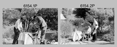
Photograph - Silver Service Morning Tea – Army Survey Regiment, Fortuna, Bendigo, 1991
These six photos were taken in the grounds of the Army Survey Regiment, Fortuna in spring 1991. MAJ Ray Redman appears in his mess dress by the Roman fountain, serving a silver service morning tea to CPL Pat Drury, as a result of a losing bet on the 1991 Rugby League Grand Final. Pat Drury was a very keen rugby league supporter and followed Penrith, who lost its first Grand Final appearance to the Canberra Raiders in 1990. Penrith reversed the result the following year against Canberra winning their first premiership. This occasion is covered on page 152 of Valerie Lovejoy’s book 'Mapmakers of Fortuna – A history of the Army Survey Regiment’ ISBN: 0-646-42120-4.This is a set of six photographs of two Army Survey Regiment personnel in the grounds of Fortuna, Bendigo, 1991. The photographs were on 35mm negative film and were scanned at 96 dpi. They are part of the Army Survey Regiment’s Collection. .1) to .6) - Photo, black & white, 1991, MAJ Ray Redman and CPL Pat Drury. No personnel are identified.royal australian survey corps, rasvy, army survey regiment, army svy regt, fortuna, asr -
 Bendigo Military Museum
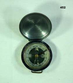
Equipment - COMPASS JAPANESE, C. 1939 - 45
... surveying-terrestrial ...Item souvenired by Leslie John Kupke No VX93892 2nd AIF. Refer 2054.2 for his service history. Japanese compass with hinged cover. Casing made of metal. N,S,E,W in Japanese. Case has loops for attaching to a strap.PATEN 2908 stamped on back (worn but visible)surveying-terrestrial, military - equipment, japan -
 Bendigo Military Museum
Photograph - Royal Australian Survey Corps Course Photographs, c1960s, 1948
The first three photographs of Royal Australian Survey Corps training courses were probably taken in the 1960s. As they lack any annotation, the course title/type, trainee and instructor names, dates and locations are unknown. The courses were possibly conducted at the Army Survey Regiment at Fortuna, Bendigo; or the School of Military Survey either at Balcombe Victoria; or Bonegilla, Victoria. The fourth photograph is annotated with the course title and date, however the course type, trainee and instructor names and location are unknown.This is a set of photographs of Royal Australian Survey Corps courses from the 1960s and 1948. All four photographs were printed on photographic paper and are part of the Army Survey Regiment’s Collection. The photographs were scanned at 300 dpi. .1) Photo, black & white RASvy course trainees c1960s .2) Photo, black & white RASvy course trainees and instructors c1960s .3) Photo, black & white RASvy course trainees c1960s .4) Photo, black & white RASvy 1/48 Basic Course trainees 1948.1) to .3) no annotation .4) “1/48 Basic Course” written on backroyal australian survey corps, rasvy, army survey regiment, army svy regt, fortuna, asr -
Glenelg Shire Council Cultural Collection
Photograph - Photograph - Aerial Photo railway line between Heywood and Rennick, 03/05/1952
Victorian Railways aerial survey record print of the railway line between Heywood and Rennick (S.A. border) Black and white, white vertical strip on imageFront: 'to Rennick, Heywood from Melbourn' in the whites strip Back: 'Heywood - Rennick 21078 - 19369 235m 70c Heywood' - all black ink. Purple VR aerial survey stamp. '3 May 1952' - black stamp -
Glenelg Shire Council Cultural Collection
Photograph - Photograph - Aerial Photo railway line between Heywood and Rennick, 03/05/1952
Victorian Railways aerial survey record print of the railway line between Heywood and Rennick (S.A. border) Black and white, white vertical strip on imageFront: Annotations in black pencil added at a later date Back: 'Heywood - Rennick 21149 - 19430 240m 79c Heywood' - all black ink. Purple VR aerial survey stamp. '3 May 1952' - black stamp -
Glenelg Shire Council Cultural Collection
Photograph - Photograph - Aerial Photo railway line between Heywood and Rennick, 03/05/1952
Victorian Railways aerial survey record print of the railway line between Heywood and Rennick (S.A. border) Black and white, white vertical strip on imageFront: Annotations in black texta added at a later date Back: 'Heywood - Rennick 21358 - 19629 258m 23c Heywood' - all black ink. Purple VR aerial survey stamp. '3 May 1952' - black stamp -
Glenelg Shire Council Cultural Collection
Photograph - Photograph - aerial view of railway line, 03/05/1952
Victorian Railways aerial survey record print of the railway line between Heywood and Rennick (S.A. border) Black and white, white vertical strip on imageFront: Notations in black pen, added at a later date Back: 'Heywood - Rennick 21082 - 19373 235m 73c Heywood' - all black ink. Purple VR aerial survey stamp. '3 May 1952' - black stampvictorian railways, aerial photography, train line -
Glenelg Shire Council Cultural Collection
Photograph - Photograph - Aerial Photo railway line between Heywood and Rennick, 03/05/1952
Victorian Railways aerial survey record print of the railway line between Heywood and Rennick (S.A. border) Black and white, white vertical strip on imageFront: 'to Rennick, Heywood from Melbourn' in the whites strip Back: 'Heywood - Rennick 21077 - 19368 235m 67c Heywood' - all black ink. Purple VR aerial survey stamp. '3 May 1952' - black stamp -
Glenelg Shire Council Cultural Collection
Photograph - Aerial Survey Railway Record Print – 1952, 03/05/1952
Victorian Railways aerial survey record print of the railway line between Heywood and Rennick (S.A. border) Black and white, white vertical strip on image.Front: Annotations in black ink added at a later date Back: 'Heywood - Rennick 21151 - 19432 241m 14c Heywood' - all black ink. Purple VR aerial survey stamp. '3 May 1952' - black stamp -
 Bendigo Military Museum
Photograph - RA Svy Project C4 Aerodist Operation, Eastern Arnhem Land, NT, 1967
... surveying ...This is a set of 30 photographs of Royal Australian Survey Corps (RA Svy) personnel from Central Comd Fd Svy Unit (Adelaide) on Aerodist survey operation - Project C4 in Eastern Arnhem Land, Northern Territory in 1967. Photos of personnel were taken either at the operations base at Numbulwar or the main base at Gove (Nhulunbuy). RA Svy conducted nineteen Aerodist operations for 12 years from 1964 to 1975. Aerodist MRC2 was a tellurometer-based system adapted for aircraft to accurately measure distances between non-intervisible ground survey stations, using the aircraft as an intermediate station. Lower order geodetic results could be achieved by survey network trilateration. The measured distances between stations formed survey networks from which each station’s latitude and longitude was computed. Aerodist MRC2 was RA Svy’s major horizontal control survey tool for mainly medium scale topographic mapping (scale 1:100,000 Class A being spatially accurate to within 50 metres) in PNG, northern NT, north-west WA, Kalimantan Barat (West) Indonesia, Sumatra Indonesia, Gulf of Carpentaria and Cape York, QLD. In 1967, the Aerodist MRC2 Master equipment was installed in the aircraft featured in this set of photos, Executive Air Services’ (Essendon VIC) Grand Aero Commander VH-EXX. It was the same aircraft type and company contracted to Division of National Mapping for Aerodist MRC2 surveys. From July to October 1967 the aircraft was attached to Central Comd Fd Svy Unit (Adelaide - Major Don Ridge) on Project C4 eastern-Arnhem Land NT, where 317 Aerodist lines measuring 17,300 line miles were successfully completed. This was the most productive Aerodist project thus far. The most common helicopter used by RA Svy up to 1972 was the civilian Bell 47G-2 and the Sioux Light Observation Helicopters (LOH), the Australian Army’s equivalent featured in this photo set. These light observation helicopters had a limiting load carrying capacity of up to about 500 pounds. By comparison, one Aerodist team including two people weighed up to 1,500 pounds. Source: Royal Australian Survey Corps – Aerodist Years 1964-1975 by Peter Jensen. This is a set of 30 photographs of Royal Australian Survey Corps (RA Svy) personnel on Aerodist survey operations in Eastern Arnhem Land, Northern Territory in 1967. The photographs are on 35mm negative film and scanned at 96 dpi. They are part of the Army Survey Regiment’s Collection. .1) to .4) - black & white, 20th August 1967, Project C4 Aerodist Operations Base - Numbulwar, NT. .5) - Photo, black & white, 1967. Probable wrecked Indonesian fishing vessel. .6) to .8) - Photo, black & white, 1967. Unidentified survey operations base, L to R: unidentified personnel. .9) - Photo, black & white, 1967. Unidentified survey operations base, unidentified soldier driving a Haflinger 4x4 Light utility vehicle. .10) - Photo, black & white, 1967. Unidentified survey operations base, L to R: unidentified technician. .11) - Unidentified technician reading two survey altimeters to compute corrections to the measured distances for atmospheric refraction and to compute the sea level distances from the slope distances aircraft to the ground stations. .12) - Photo, black & white, 1967. Unidentified survey operations base, L to R: unidentified personnel. .13) to .16) - Photo, black & white, 1967. Unidentified personnel operating remote Aerodist MRC2 ground instruments. .17) to .18) - Photo, black & white, 1967. Unknown RA Svy office location. .19) to .20) - Photo, black & white, 1967. Aerodist MRC2 Master equipment. .21) to .22) - Photo, black & white, 1967. Aero Commander VH-EXX probably at Gove, NT, Central Comd Fd Svy Unit (Adelaide) – OC Major Don Ridge. .23) to .25) - Photo, black & white, 1967. Aero Commander VH-EXX probably at Gove, NT. Unidentified personnel. .26) - Photo, black & white, 1967. Aero Commander VH-EXX probably at Gove, NT. Aerodist antenna pods are visible on the aircraft. .27) to .29) - Photo, black & white, 1967. Australian Army Sioux Light Observation Helicopter (LOH) probably at Gove, NT. .30) - Photo, black & white, 1967. Panelled U337 survey station, visible as a white cross on aerial identification photo..1P to .2P – date and location on edge of film negative. .5P to .28P – no annotations .29P - annotated in white ‘RW-JEP Gove NT’ .30P - annotated in white ‘U337 Spool No1 Jun67’royal australian survey corps, rasvy, army survey regiment, army svy regt, fortuna, asr, aerodist, surveying, central comd fd svy unit -
Whitehorse Historical Society Inc.
Article, Janette is waste wise, 18/09/1991 12:00:00 AM
Article from Nunawading Post on a 10 year old Janette Lewis from Forest Hill.Article from Nunawading Post on a 10 year old Janette Lewis from Forest Hill winning first place in a state-wide science competition for her survey on domestic garbage and waste minimisation.Article from Nunawading Post on a 10 year old Janette Lewis from Forest Hill. lewis, janette, garbage collection -
 Bendigo Military Museum
Photograph - Army Survey Regiment – Regimental Training, c1960s
These photographs of RASvy personnel from the Army Survey Regiment undertaking regimental training lack any annotation that could identify names, dates and locations. The training was possibly conducted at Balcombe and Dromana, located on the Mornington Peninsula, Victoria. There is no explanation on the meaning of the annotation on back of the last photograph.This is a set of photographs of Army Survey Regiment personnel undertaking regimental training in the 1960s. All eight photographs were printed on photographic paper and are part of the Army Survey Regiment’s Collection. The photographs were scanned at 300 dpi. .1) to .7) Photo, black & white, Regimental Training .8) Photo, black & white, possibly Regimental Training.1) to .7) annotated on back “Regimental Training” .8) annotated on back “Fatted Pig-Coal Lift-Western Mines”royal australian survey corps, rasvy, army survey regiment, army svy regt, fortuna, asr -
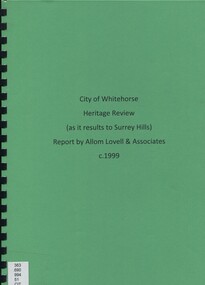 Surrey Hills Historical Society Collection
Book, City of Whitehorse Heritage Review (as it relates to Surrey Hills), 1999
A street by street survey of each of the proposed precincts was undertaken. For each precinct, building fabric was defined in terms of intactness, scale, construction type, architect and predominant eras of construction.A street by street survey of each of the proposed precincts was undertaken. For each precinct, building fabric was defined in terms of intactness, scale, construction type, architect and predominant eras of construction.cultural property, protection of historic sites, heritage overlay precincts, heritage review, building citations -
Whitehorse Historical Society Inc.
Article, LGB praise for Council, 1994
Leonie Burke, Local Government Board Chairperson was impressed by Nunawading's preparation and community inclusion in the impending amalgamation decision.Leonie Burke, Local Government Board Chairperson was impressed by Nunawading's preparation and community inclusion in the impending amalgamation decision. Cr Abbott stated Box Hill's resident survey was incorrect regarding rates after a merger.Leonie Burke, Local Government Board Chairperson was impressed by Nunawading's preparation and community inclusion in the impending amalgamation decision. local government, city of box hill, city of nunawading, city of whitehorse, amalgamations, local government finance -
Glenelg Shire Council Cultural Collection
Photograph - Aerial Survey Railway Record Print – 1952, 03/05/1952
Victorian Railways aerial survey record print of the railway line between Heywood and Rennick (S.A. border) Black and white, white vertical strip on imageFront: Annotations in red and black ink made at a later date Back: 'Heywood - Rennick 21085 - 19376 236m 9c Heywood' - all black ink. Purple VR aerial survey stamp. '3 May 1952' - black stamp -
Glenelg Shire Council Cultural Collection
Photograph - Photograph - Aerial Photo railway line between Heywood and Rennick, 03/05/1952
Victorian Railways aerial survey record print of the railway line between Heywood and Rennick (S.A. border) Black and white, white vertical strip on imageFront: annotations in red and black ink, made at a later date Back: 'Heywood - Rennick 21084 - 19375 235m 31c Heywood' - all black ink. Purple VR aerial survey stamp. '3 May 1952' - black stamp -
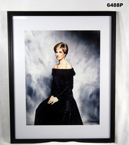 Bendigo Military Museum
Photograph - HRH The Princess of Wales "Lady Diana" - Colonel in Chief of the Royal Australian Survey Corps, 1988
Her Majesty, Queen Elizabeth II approved the appointment of HRH The Princess of Wales "Lady Diana" as the Colonel in Chief of the Royal Australian Survey Corps (RASvy) on 1 July 1988. A copy of this image was presented to RASvy for official use.Framed photograph of HRH The Princess of Wales "Lady Diana" - Colonel in Chief of the Royal Australian Survey Corps in a black dress, white border and black frame.royal australian survey corps, rasvy, fortuna, army survey regiment, army svy regt, asr -
 Bendigo Military Museum
Photograph - AITA Award - RA Svy’s AUTOMAP 2 Computer Based Map Production System, Army Survey Regiment, Fortuna, Bendigo, 1984
This collection of three photos of the Australian information Technology Award (AITA) won by the Royal Australian Survey Corps (RA Svy) AUTOMAP 2 computer-based map production system, was taken in 1984 at the Army Survey Regiment, Fortuna, Bendigo. The following article appeared in the ARMY Newspaper on Thursday 21st February 1985. ‘In computerised map production. Survey soldiers lead the world. BENDIGO: Army surveyors have been put on the map as world leaders in computerised map production following the Australian information Technology Awards. RA Svy won the Computer Assisted Draughting – Mapping section for its Automap II System which has created considerable interest among overseas defence experts. The award for the digital mapping system was accepted by OC Air Survey Sqn, MAJ Rob John, who said it was a great morale-booster for the soldiers of the Bonegilla (sic)* -based Army Survey Regiment. "Setting up a state-of-the-art system like Automap II. is an enormous task, " he said. "We started in August 1983 and it's only recently that we have achieved production results. "We were all very pleased to have our efforts recognised in this way. “Of course, credit must also go to the Intergraph Corporation for manufacturing the system and carrying out most of the development." RA Svy is responsible for producing all of Australia's maps used for defence purposes. Its topographical maps have a scale of 1:50,000 or 1:100,000 although Automap II has the capability of producing smaller scale maps - down to 1: 2,000,000. Automap II consists of three computers and three sub-systems: input, raster scanning, and graphic edit. The input sub-system has eight stereo plotters, two interactive graphic workstations and a system manager workstation. The stereo plotters use superimposition optics to digitise features from aerial photographs. It incorporates a voice recognition system so the operator can simply say "House", "Windmill", etc; and the relevant feature will be incorporated in the digital picture. Individual map separations are scanned and converted by the raster scanning sub-system to a digital raster image. This image is then converted to a graphics file in Intergraph format.’ *Note – the Army Survey Regiment was located in Bendigo, not Bonegilla as incorrectly stated in the article. The article appears on Page 137 of Valerie Lovejoy’s book 'Mapmakers of Fortuna – A history of the Army Survey Regiment’ ISBN: 0-646-42120-4. Additional history of the AUTOMAP 2 system with historic photographs is covered in pages 119, 137-143 and 157 of the 'Mapmakers of Fortuna’ book. See item 6223.23P for additional history and photographs of the AUTOMAP 2 system.This collection of three photos of the Australian information Technology Award (AITA) won by the Royal Australian Survey Corps (RA Svy)’s AUTOMAP 2 computer-based map production system, was taken in 1984 at the Army Survey Regiment, Fortuna, Bendigo. The photographs are printed on photographic paper and are part of the Army Survey Regiment’s Collection. The black and white photographs were scanned at 300 dpi. .1) - Photo, black & white, 1984, AITA Award sitting between the dual screens of an AUTOMAP 2 Graphic Edit Workstation. .2) - Photo, black & white, 1984, MAJ Job Johns (centre) and two of Intergraph Corporation IT engineers proudly hold the AITA Award next to an AUTOMAP 2 Graphic Edit Workstation. .3) - Photo, black & white, 1984, The AITA Award displayed on a pedestal in the Army Survey Regiment Officers Mess. .1P to .3P –No personnel are identified. ‘AITI Award to AUTOMAP II 1984’ annotated on cover sleeve. royal australian survey corps, rasvy, army survey regiment, army svy regt, fortuna -
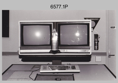
 Bendigo Military Museum
Photograph - Tasks Demonstrated by Royal Australian Survey Corps Technicians, c1990s
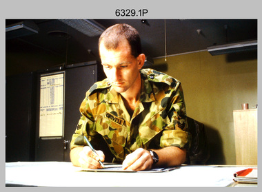
This is a set of 17 photographs of technicians from the Royal Australian Survey Corps undertaking technical tasks circa 1990s. Photos .1P to .9P were taken at the Army Survey Regiment, Fortuna, Bendigo. Photos .10P to .15P and .17P of students operating survey equipment, were taken at the School of Military Survey, Bonegilla and survey stations surrounding Lake Hume. The base camp at photo .16P was probably taken at Sandy Creek, near Tallangatta Victoria, during the field phase of a basic or advanced RA Svy training course. CPL Steve Nokes appearing in photo .17P was attending the 1/90 Map Control Survey Course.This is a set of 17 photographs of technicians from the Royal Australian Survey Corps undertaking technical tasks at the Army Survey Regiment, Fortuna, Bendigo, and the School of Military Survey, Bonegilla c1992. Colour photos are on 35mm slide film and were scanned at 96 dpi. Photo .17P is in black & white, printed on photographic paper and scanned at 300 dpi. The photos are part of the Army Survey Regiment’s Collection. .1) – Photo, colour, c1992, Aerial photography Assessment, SGT Tony Grivell. .2) – Photo, colour, c1992, Aerial photography Assessment, L to R: WO2 Noel McNamara and LCPL Grant Lloyd. .3) – Photo, colour, c1992, Wild PUG4 point transfer device, LCPL Mark Fedden. .4) – Photo, colour, c1992, AUTOMAP 2 Graphic Edit Workstation, unidentified technician. .5) – Photo, colour, c1992, Heidelberg Speedmaster 102 computer-controlled five colour lithographic offset printing press, CPL Nick Vanderzwan. .6) – Photo, colour, c1992, Daylight film contact frame, SPR Ken Labourchardiere. .7) – Photo, colour, c1992, Heidelberg Speedmaster 102 Map Colour Evaluation Workstation, SGT Stuart Ridge. .8) – Photo, colour, c1992, Map proof evaluation, CPL John Bragg. .9) – Photo, colour, c1992, Wohlenberg MCS-2 guillotine, unidentified technician. .10) – Photo, colour, c1992, Wild T2 Theodolite, L to R: SPR Matt Arnold, SPR Kim Baker. .11) – Photo, colour, c1992, Wild T2 Theodolite, L to R: SSGT Bob Bright, SPR Kim Baker. .12) to .14) – Photo, colour, c1992, MRA-7 Tellurometer, CPL Mark Bourne. .15) – Photo, colour, c1992, Plane Tabling, CPL Mark Bourne. .16) – Photo, colour, c1992, School of Military Survey base camp, Sandy Creek, VIC. .17) – Photo, black & white, 1990, MRA-7 Tellurometer, CPL Steve Nokes. .1P to .16P - There are no annotations. .17P – annotated on back ‘CPL NOKES WITH MRA7 ON 1/90 MAP CONTROL COURSE’royal australian survey corps, rasvy, army survey regiment, army svy regt, school of military survey, fortuna, asr -
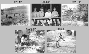
 Bendigo Military Museum
Photograph - Royal Australian Survey Corps Surveyors in the Field – Northern Territory and Queensland, 1959 – 1960
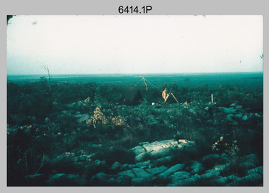
... surveying ...This is a set of 10 photographs of surveyors and support staff in the field undertaking duties in the Northern Territory and North Queensland in 1959 – 1960. The surveyors were employed in the establishment of mapping and geodetic control. In this era surveyors used theodolites to observe horizontal and vertical angles and tellurometers to measure base line distances between survey stations. Laplace survey observations seen in Photo .1P was a series of precise observations carried out at geodetic survey stations to determine astronomic latitudes, longitudes and azimuths to achieve maximum precision in the survey network. Laplace observations were necessary in a geodetic network at every 6th survey station, however the National Mapping Council specified at this time the spacing would be ideally between 4-6 survey stations. The cairn shown in photo .4P was built by RASvy as a landmark over a trigonometric survey station. It was dismantled in 1960 to enable re-occupation and survey observations. It was not restored to the condition shown in the photo.This is a set of 10 photographs of surveyors and support staff in the field undertaking duties in the Northern Territory (NT) and Queensland (QLD) in 1959 – 1960. The photographs were printed on photographic paper and are part of the Army Survey Regiment’s Collection. The photographs were scanned at 300 dpi. .1) - Photo, colour, 1959. Tony Slattery occupying a Laplace survey station on a hill in the Mount Young area of the NT. .2) - Photo, colour, 1959. Surveyors’ camp in the Mount Young area of the NT, L to R: Spencer Snow and Tony Slattery. .3) - Photo, colour, 1959. Surveyors’ camp in the Peckman Hill area, near Katherine in the NT. .4) - Photo, colour, 1959. Cairn on Trig Hill, Borroloola, NT. Built by Spencer Snow, Tom Royle and Jack McCabe. .5) - Photo, colour, 1959. Survey party taking a break next to their Austin Champ vehicle, in transit between Katherine, NT and Wyndam WA. L to R: Tony Slattery, Dave Owens, John Van De Graff. .6) - Photo, colour, 1960. Surveyors’ camp between Mount Isa, QLD and Borroloola, NT. L to R: Pat Cox and John Van De Graff prepare their meal on an open fire. .7) - Photo, colour, 1960. Surveyor - Dennis Woods undertaking survey observations, using MRA1 tellurometer to measure base-line distances NW of Mount Isa, QLD. .8) - Photo, colour, 1960. Unidentified surveyors assessing recovery of their stalled Studebaker truck vehicle after attempting a water crossing in the NT. .9) - Photo, colour, 1960. Unidentified surveyor making batches of bread at a camp in the NT. Seen in the photo placing a lid with hot coals onto the camp oven. .10) - Photo, colour, 1960. Unidentified survey party occupying a survey station on a hill in the Mount near the Lawn Hill area, NW of Mount Isa, QLD. A MRA1 tellurometer to measure base-line distances appear on the right side of the photo. .9) - Photo, colour, 1960. Unidentified surveyors assessing recovery of their stalled Studebaker truck vehicle after attempting a water crossing in the NT. .10) - Photo, colour, 1960. Unidentified surveyor making batches of bread at a camp in the NT. Seen in the photo placing a lid with hot coals onto the camp oven. .1P to .10P annotated on back – personnel names, the year and the location. royal australian survey corps, rasvy, army survey regiment, asr, army svy regt, fortuna, surveying -
Glenelg Shire Council Cultural Collection
Photograph - Photograph - Aerial Photo railway line between Heywood and Rennick, 03/05/1952
Victorian Railways aerial survey record print of the railway line between Heywood and Rennick (S.A. border) Black and white, white vertical strip on imageFront: Annotations in red ink and black texta, added at a later date Back: 'Heywood - Rennick 21530 - 19793 274m 9c Puralka ' - all black ink. Purple VR aerial survey stamp. '3 May 1952' - black stamp -
 St Kilda Historical Society
Photograph - Photo map, 13/01/1968
One of a series of photo-maps produced for the Department of Crown Lands and Survey (1857-1983). For correlation with a current map, and access to other historical photo maps of Victoria, see the Historic Photo-Maps Index published by the Department of Environment, Land, Water and Planning at https://services.land.vic.gov.au/DELWPmaps/historical-photomaps/Black and white aerial photograph2138 State Aerial Survey Melbourne 1968 Proj. Run 26 13.1.68 5100 ASL 203st kilda west, albert park, fawkner park, south yarra, prahran, windsor, 1968 -
 St Kilda Historical Society
Photograph - Photo map, 11/01/1968
One of a series of photo-maps produced for the Department of Crown Lands and Survey (1857-1983). For correlation with a current map, and access to other historical photo maps of Victoria, see the Historic Photo-Maps Index published by the Department of Environment, Land, Water and Planning at https://services.land.vic.gov.au/DELWPmaps/historical-photomaps/Black and white aerial photographVic 2132 State Aerial Survey Melbourne 1968 Proj. Run 27E 11.1.68 5100 ASLst kilda, st kilda west, st kilda pier, catani gardens, st kilda beach, albert park, 1968