Showing 853 items matching "surveyors"
-
 Unions Ballarat
In step with Sturt (Don Woodward Collection), Swan, Keith et al, 1979
The book, targeted at school students, covers the years of Sturt's three expeditions. The authors question Sturt's capability as a surveyor and his leadership.Australian history.Graphic book; 115 pages. Dustjacket: plastic covering; brown and white background; black and white map of Sturt's journey along Murrumbidgee and the Murray River; black, gold and white lettering; authors' names and title. Cover: white and black lettering; authors' names and title.btlc, ballarat trades and labour council, ballarat trades hall, sturt, charles, history - australia, australia - explorers -
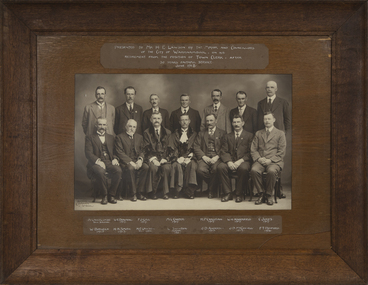 Warrnambool and District Historical Society Inc.
Photograph - Framed Photograph on the Occasion of Horace Lawson's Retirement, Arthur Jordan, 1918
This photograph was given to Horace Lawson on the occasion of his retirement in 1918 as Town Clerk of Warrnambool. The photographs are of the Town Clerk, the Town Surveyor, the Mayor and Councillors in June 1918. The Mayor, William Swinton and the Town Clerk, Horace Lawson are in civic robes. Horace Lawson had a distinguished career as the Town Clerk of Warrnambool from 1893 to 1918 (which is actually 25 years, not 30 years as stated on the photograph). Lawson was a keen cyclist and a member of the Warrnambool Volunteer Army Corps. He left Warrnambool in 1918 to take up the position in Melbourne as Secretary of the Municipal Association of Victoria. The photographer, Arthur Jordan, working in Warrnambool at the end of the 19th century and in the early 20th century, was well-known, particularly for his photographs of civic affairs. This photograph is of considerable interest as it concerns the retirement of Horace Lawson, an influential and highly-respected municipal officer in Warrnambool at a time of great growth in the town/city.This is a black and white photograph in a wooden frame with a heavy card inset and glass covering. The glass is broken at the right hand corner. On the back is a wire piece for hanging the photograph. The photograph is of 14 men with the names and inscription included.Presented to Mr. H.E. Lawson by the Mayor & Councillors of the City of Warrnambool on his retirement from the position of Town Clerk after 30 years faithful service June 1918 A.Lavercombe Town Surveyor W.E.Downing 1917 F.J.Gill 1917 M.L.Carter 1917 W. Burleigh 1915 H.H.Smith 1917 H.E.Lawson Town Clerk W. Swinton Mayor 1903 R.P. Christian 1917 W.H. Haberfield 1917 C. Jukes 1917 J.D.Anderson 1913 J.D. McConnell 1914 F.T. Retford 1916 Arthur Jordan Wboolarthur jordan, horace lawson, william swinton, warrnambool councillors -
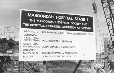 Ringwood and District Historical Society
Photograph, Maroondah Hospital Stage 1 for the Maroondah Hosptial Society and the Hospitals & Charities Commission of Victoria construction site, 1973
+Additional Keywords: Architects - R.S. Demaine, Russell, Trundle, Armstrong & Orton / Mechanical & Electrical Consultants - W.L. Bassett & Partners / Structural Consultants - John Connell & Associates / Quantity Surveyors - Beattie, Prowse & Associates / Builder - John R. & E. Seccull Pty Ltd.Written on backing sheet, "1973". -
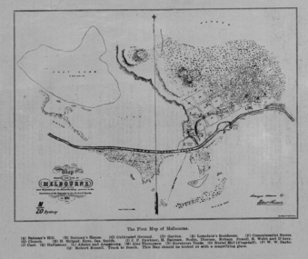 Federation University Historical Collection
Image, The First Map of Melbourne, 1837
Scanned from "The Old Pioneers' Memorial History of Melbourne From the Discovery of Port Phillip to the World War".First map of Melbourne showing the location of Batman's Hill, Batman's House, Lonsdale's Residence, Commissarist Stores, location of John Falwkner, R. Webb, D'Acry, Carr, Diprose, Nodin, Robson, Alex Thompson, Surveyors tents, Burial Hill (AKA Flagstaff Hill)port phillip bay, batman's hill, batman's house, lonsdale's residence, commissarist stores, john fawkner, r. webb, d'acry, carr, diprose, nodin, robson, alex thompson, surveyors tents, burial hill, flagstaff hill -
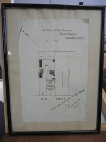 Bendigo Historical Society Inc.
Document - DUDLEY HOUSE COLLECTION: PLAN OF DUDLEY HOUSE, 1888
Wooden framed copy of allotment plan of Old Survey Office Premises (Dudley House) Sandhurst, under glass in thin black wooden frame. Notation on bottom reads, For the information of the Secty for lands and signature of T.W.Pinniger D.S. (District Surveyor) 5/4/88T.W.Pinniger D.S.document, certificate, plan -
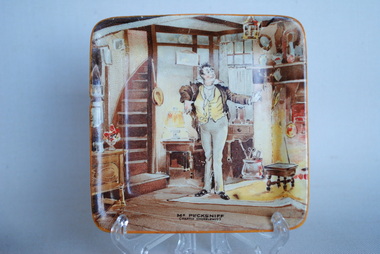 Anglesea and District Historical Society
Pin dish, New Hall Pottery Co Ltd, 1951-56
Small square dish depicting a character from "The Life and Adventures of Martin Chuzzlewit", by Charles Dickens (1843-44). The character on the dish is one of Dickens' great villains, Seth Pecksniff, who is a sanctimonious surveyor and architect "who has never designed or built anything'.Picture of Mr Pecksniff in kitchen. Front bottom: MR PECKSNIFF / (Martin Chuzzlewit) Back: New Hall Hanley / Staffordshire England. dickens, pecksniff -
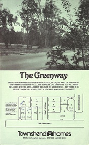 Ringwood and District Historical Society
Document - Folder, Greenway Estate Subdivision, Heathmont, Victoria - 1981
Manilla folder containing single page advertisement for sale of 13 residential allotments, photocopied plan section of surveyor's certificate, letter from vendor to agent dated 24th February, 1981, and typewritten price list. Subdivision includes Possum Lane and The Greenway, Heathmont. Vendor - Townshend Homes (Vic) Pty Ltd., 395 Canterbury Road, Vermont, 3133, Phone 874-1066. P.O. Box 64, Vermont, 3133. Agent - C.E. Carter & Son, 122 Whitehorse Road, Ringwood, Vic., 3134. -
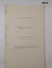 Bendigo Military Museum
Administrative record - Trilateration with the Tellurometer - GRL Rimington 1958, Department of National Development , ACT, 26 May 1958
trilateration with the tellurometer by GRL Rimington L.S MIS (Aust) Chief Topographic Surveyor, Department of National Development, Australia. This paper was delivered to the Institute of Surveyors Conference, Brisbane 26 May 1958. This paper is a summary of Electronic distance measurements carried out in 1957 in Central Australia by officers of the division of National Mapping, Department of National Development. Trilateration is a surveying Technique that uses measurements of the sides of triangles to determine relative position.A 11 page foolscap size stapled paper report. Two holed punched with dis-coloured pages due to age.royal australian survey corps, rasvy, fortuna, army survey regiment, army svy regt, asr, division of national mapping, surveying -
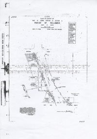 Eltham District Historical Society Inc
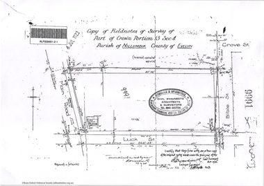
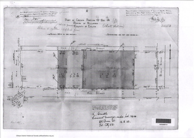
Document - Survey Plan, Country Roads Board et al, SP 12272A, Eltham-Yarra Glen Road; Brougham St to Dalton St, 1970-1976
1970 C.R.B. Plan of Survey of Part of Crown Portion 12 Section 4 Parish of Nillumbik, County of Evelyn Eltham-Yarra Glen Road, Shire of Eltham Shows Surveyor field notes, property ownership and building type and construction. John L. Roberts, Licensed Surveyor as noted 4 June 1970 Amendments in black by John L. Roberts, L.S. 20-12-76 See also EDHS_05783 (1958)eltham-yarra glen road, 1970, 1976, a.f. munday, brougham street, dalton street, eltham, eltham clinic, g.t. & e.a. donnelly, jarrold cottage, l.m. jarrold, m.s.m. skipper, main road eltham, map, maria street, matcham skipper, mobil service centre (eltham), mobil service station, napoleon street, survey plan, white cloud cottage, country roads board -
Port Melbourne Historical & Preservation Society
Plan - Danks Street from Pickles Street to Esplanade East, Town of Port Melbourne, 28 Feb 1893
Plan of Danks Street, from Pickles Street to Esplanade East and bearing the seal of the Borough of Port Melbourne as well as agreement to contract to carry out works.A.V. Heath (Town Surveyor):Michael Minahan (?) (Contractor):J.J. Bartlett (Mayor):Prohasky (Councillor):E.C. Crockford (Town Clerk):W. Harrison (Witness)engineering - roads streets lanes and footpaths, engineering - fences, local government - borough of port melbourne, arthur victor heath, james john bartlett, william henry prohasky, edward c crockford, town clerks, w harrison, michael minahan -
 Orbost & District Historical Society
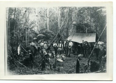
black and white photograph, 1897
This photograph shows a group of surveyors setting up at Treasury Camp - April 18 1897. Treasury camp was possibly in the Murrungowar area in East Gippsland.This is a pictorial record of a late 19th century bush camp set up by surveyors involved in determining land settlement in East Gippsland.A faded black / white photograph on a black buff card of a group of men and several pack horses standing around a campfire. The camp is in a clearing in dense forest and tents are set up with some bark coverings. There is a copy with the original.surveyors-camp-east-gippsland -
 Federation University Historical Collection
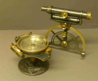
Instrument - Miner's Dial, c early 1900s
A miner's dial was used by surveyors to determine the direction of underground tunnels and roadways. The inclinometer allowed measurement of the angles at which mine tunnels descend into the ground.A rare miner's dial in a hinged timber box.This surveying instrument consists of a theodolite monsblr on a magnetic compass, which sits on the vertical tapered spigot of a base plate. Fits tripod catalogued item 4133. Inside the box lid is the supplier's label - W. Travill (successor to D. Esdale) of 146 Little Collins Street, Melbournemining, ballarat school of mines, surverying, scientific instruments, scientific objects -
 Robin Boyd Foundation
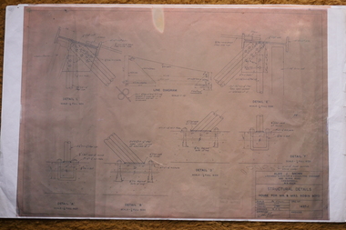
Drawing - Architectural, 290 Walsh Street, South Yarra, Apr-58
Project: House for Mr and Mrs Robin Boyd drawn by JJJS of Alan J Brown - Surveyor and Engineer. Structural details drawings 1437-1Structural Details, Colour Photocopy -
 Robin Boyd Foundation
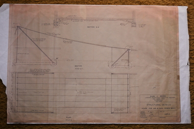
Drawing - Architectural, 290 Walsh St South Yarra, Apr-58
Project: House for Mr and Mrs Robin Boyd drawn by J.J.J.S of Alan J Brown surveyor and engineer. Structural details drawings 1437-2Working drawing, Colour photocopy -
 Bendigo Historical Society Inc.
Photograph - HARGREAVES STREET BENDIGO
Copy of black and white photograph. Image taken from Hargreaves Street, looking towards the Jewish Synagogue. Warren's Timber yard in foreground. Copy of research on site of synagogue, two letters written in 1855, to the Surveyor General Melbourne and one to G. Stanker (?) (name indecipherable)bendigo, streetscape, hargreaves street, jewish, synagogue, warren's timber yard -
 Bendigo Historical Society Inc.
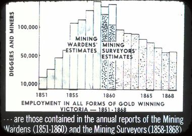
Slide - DIGGERS & MINING: DIGGERS & MINING
Diggers & Mining: Diggers & Mining. Graph depicts employment in all forms of gold winning Victoria (1851-1868) - - - - are these contained in the annual reports of the Mining Wardens (1851-1860 and the Mining Surveyors (1858-1868) Markings: 44/ 994:LIF 1. Used as a teaching aid.hanimounteducation, tertiary, diggers & miners -
 Orbost & District Historical Society
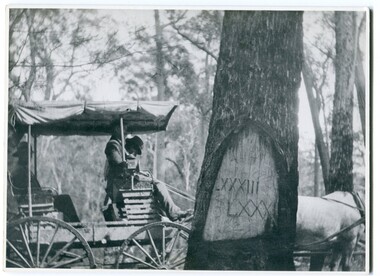
black and white photograph, 1913
When marking a boundary for a registered plan, a surveyor would place “Reference Marks” with a stated bearing and distance to a boundary corner. These trees were typically marked by cutting the bark of the tree in a shield or blaze. Until July 1886, surveyors were only able to use trees as reference marks to boundary corners. After July 1886 surveyors were able to use “permanent marks” which were either a glass bottle, gas pipe or iron bolt (for homestead surveys only). This photograph shows the reference tree, 83 miles from Marlo via the original surveyed road v ia Sydenham Inlet and Tamboon, south of Mount Drummer to the New South Wales border - now the Princes Highway.This is a pictorial record of an old survet tree. Knowledge of their location, abundance and condition not only provide important insights to past survey practice, but also provide a lasting legacy of a regions land-use history. Old survey trees serve as one of the few remaining physical legacies of early European land settlement history.A large black / white photograph of a horse and buggy pulled up alongside a reference tree which has notches and markings of Roman numerals.on back - " Refernce tree 83 miles from Marlo........to N.S.W. Border"survey-tree reference-tree -
 Eltham District Historical Society Inc
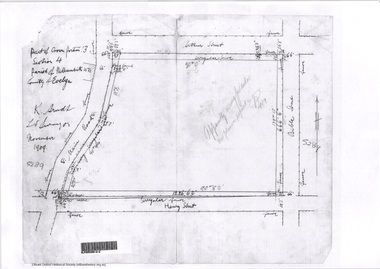
Document - Photocopy, Survey Fleld Notes of Part of Crown Portion 13, Section 4 at Eltham, Parish of Nillumbik, County of Evelyn, November 1909
Portion of land bounded by Main Road, Arthur Street, Bible Street, Henry Street Application 36708 K. Arndt, Licensed Surveyor, November 1909application 5289, arthur street, bible street, eltham, henry street, main road, map, survey plan -
 Eltham District Historical Society Inc
Document - Photocopy, Survey Fleld Notes of Part of Crown Portion 13, Section 4 at Eltham, Parish of Nillumbik, County of Evelyn, 7 January 1924
Portion of land north of Luck Street bounded by: Main Road, Bible Street Application 9991 R. Woodstock, Land Surveyor, 7 January 1924application 9991, bible street, eltham, luck street, main road, map, survey plan -
 Ringwood and District Historical Society
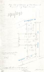
Document - Copy of Lands Department Field Notes - Subdivision of Police Reserve at Ringwood, County of Mornington, Field Notes 1900/293 - Part of O.P. R72C surveyed 1900
Foolscap size photocopy of survey map with handwritten notations. References include Mount Dandenong Road, Dublin Road, Patterson Street, Melbourne to Lilydale railway line, I certify that this is a correct copy of recorded observations made by my assistant (signed) W. Thorn, Staff Surveyor. -
 Bendigo Historical Society Inc.
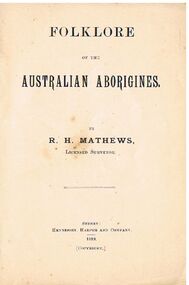
Book - ALEC H CHISHOLM COLLECTION: BOOK ''FOLKLORE OF THE AUSTRALIAN ABORIGINES'' BY R.H.MATHEWS
Booklet. ALEC H CHISHOLM COLLECTION. 35 page softcover booklet of seven legendary stories told by Aborigines. Preface by the author, R. H. Mathews (Licensed Surveyor). Published and printed in 1899 by Hennessey, Harper & Co., Sydney. Catalogue sticker ''2237 MAT'' on front cover.R. H. Mathewsbooks, collections, folklore, alec h chisholm collection, r.h.mathews, aborigines, folklore -
 Eltham District Historical Society Inc
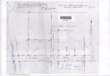
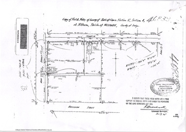
Document - Photocopy, Survey Fleld Notes of Part of Crown Portion 13, Section 4 at Eltham, Parish of Nillumbik, County of Evelyn, 31 May 1907
Portion of land east of Main Road and north of Luck Street bounded by Bible Street Application 36708 K. Arndt, Licensed Surveyor, 31 May 1907application 36708, bible street, eltham, luck street, main road, map, survey plan -
 Eltham District Historical Society Inc
Document - Photocopy, Survey Fleld Notes of Part of Crown Portion 12, Section 4 at Eltham, Parish of Nillumbik, County of Evelyn, 12 October 1910
Portion of land bounded by: Main Road, John Street, Bible Street, Pitt Street Application 38858 K. Arndt, Licensed Surveyor, 12 August 1910application 38858, bible street, eltham, john street, main road, map, pitt street, survey plan -
 Eltham District Historical Society Inc
Document - Photocopy, Survey Fleld Notes of Part of Crown Portion 12, Section 4 at Eltham, Parish of Nillumbik, County of Evelyn, 30 September 1925
Portion of land bounded by: Main Road, Franklin Street, Bible Street, Brougham Street Application 46839 R. Woodcock, Licensed Surveyor, 30 September 1925application 46839, bible street, brougham street, eltham, franklin street, main road, map, survey plan -
 Eltham District Historical Society Inc
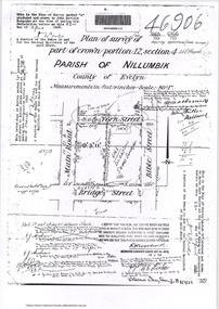
Document - Photocopy, Survey Fleld Notes of Part of Crown Portion 12, Section 4 at Eltham, Parish of Nillumbik, County of Evelyn, 18 March 1926
Portion of land bounded by: Main Road, York Street, Bible Street, Bridge Street Application 46906 R.H. Woodcock, Licensed Surveyor, 18 March 1926application 46906, bible street, bridge street, eltham, main road, map, survey plan, york street -
 Eltham District Historical Society Inc
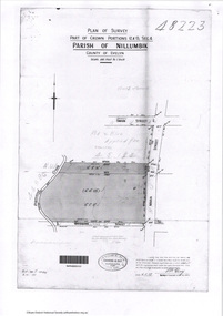
Document - Photocopy, Survey Fleld Notes of Part of Crown Portions 12 & 13, Section 4 at Eltham, Parish of Nillumbik, County of Evelyn, 6 May 1929
Portion of land bounded by: Main Road, York Street, Diamond Creek, Swan Street Application 48223 P.N. Guy, Licensed Surveyor, 6 May 1929application 48223, diamond creek (creek), eltham, main road, map, survey plan, swan street, york street -
Tatura Irrigation & Wartime Camps Museum
Photograph, Clark D, 1989
49 Hogan street Tatura, office of W. S. Murray, engineer, surveyor. Water Trust office, Dr's residence, J. Reilly's residence. Present Museum.Black and white photograph of 6 men and surveying equipment outside 49 Hogan street Tatura.on building - Walter Scott Murraywalter scott murray, water trust, museum -
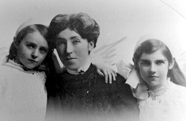 Surrey Hills Historical Society Collection
Photograph, Mrs Florence Grant and daughters
Florence Jane McDouall Stuart (1867 - 1936) married George Hudson Grant (1864 - 1910) in 1899. He was a surveyor and they lived in Albany Crescent, Surrey Hills.A black and white photograph of a lady and two young girls dressed in Edwardian clothes.florence grant (mrs), mollie grant (miss), mona grant (miss), jessie mona stuart grant (miss), jessie mona stuart webster (mrs), mona webster (mrs), clothing and dress -
 National Wool Museum
Map, Map of Western Australia Showing the Principal Sheep and Cattle Stations, 1921
Map showing the principal sheep and cattle stations of Western Australia as of 1921.MAP OF / WESTERN AUSTRALIA / Showing the Principal / SHEEP AND CATTLE STATIONS / 1921 / COMPILED & DRAWN BY HOPE & KLEM / Surveyors & Draughtsmen / 23 Barrack St, Perth, WAsheep stations -
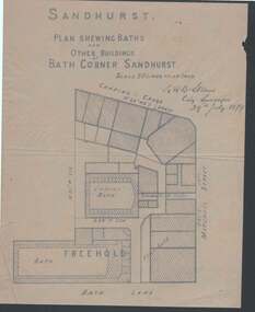 Bendigo Historical Society Inc.
Document - PLAN OF BATH CORNER: SANDHURST 1879
Buff coloured plan showing Baths and other buildings at Bath Corner Sandhurst. Scale 50 Links to an Inch. Plan area Charing Cross, Mitchell Street and Bath Lane. Plan has bearings on it. Signed by G R B Steane, City Surveyor, 29th July 1879.place, building, commercial, plan of bath corner sandhurst 1879, charing cross, ladies' bath, g r b steane