Showing 405 items
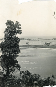
matching topography
-
 Lakes Entrance Regional Historical Society (operating as Lakes Entrance History Centre & Museum)
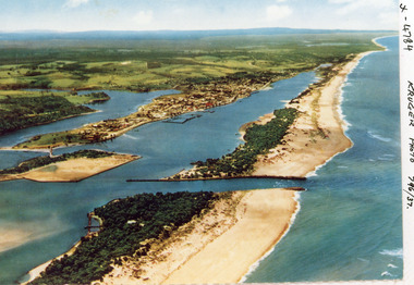
Photograph, Kruger A F, 1960c
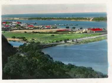
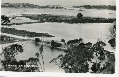
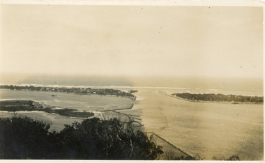
Colour photograph aerial view of the entrance from Bass Strait to the Gippsland Lakes, Australia. Shows extension to Bullock Island, town of Lakes Entrance, Cunninghame Arm and North Arm. Lakes Entrance Victoriaaerial photograph, islands, waterways, topography -
 Lakes Entrance Regional Historical Society (operating as Lakes Entrance History Centre & Museum)
Photograph, 1985c
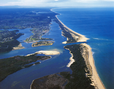
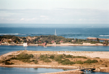
Photo was cut from Tourist brochureColour photograph showing aerial view of township and the Ninety Mile Beach. Pecks factory on Bullock Island, Old North Arm bridge, bitumen for carpark for future. Fishermen's Club near North Arm Bridge. Photo shows East end of Rigby Island and Snake Island. Glimpse of Red Bluff, Lake Bunga and Lake Tyers in far east. Lakes Entrance Victoriabridges, coast, waterways, topography -
 Lakes Entrance Regional Historical Society (operating as Lakes Entrance History Centre & Museum)
Photograph, Fraser, Ian, 1990c
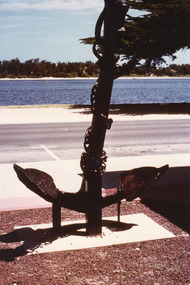
Colour photograph of the anchor situated at the Central Shopping Plaza. It shows an anchor of unknown origin, highway, Cunninghame Arm, scrub covered sand hummocks of South shore. Lakes Entrance Victoriashipwrecks, township, waterfront, topography -
 Lakes Entrance Regional Historical Society (operating as Lakes Entrance History Centre & Museum)
Postcard, 1930c
Black and white small format postcard showing the township situated on the land between the Cunninghame Arm and North Arm. Lakes Entrance VictoriaLakes Entrance from Princes Highway (on back)bridges, township, topography, waterways -
 Lakes Entrance Regional Historical Society (operating as Lakes Entrance History Centre & Museum)
Postcard, 1998c
Tinted small format postcard showing the township situated on the isthmus between two stretches of water the Cunninghame Arm and the North Arm. Work in progress widening the North Arm Bridge as seen by workmen's huts beside the southern approach. Lakes Entrance Victoriajetties, waterways, topography, township -
 Lakes Entrance Regional Historical Society (operating as Lakes Entrance History Centre & Museum)
Photograph, 1962
Image printed from 35mm slideColour photograph of Bullock Island showing cleared and grass planted south eastern area in preparation for relocation of Public Works and fishing industry facilities. Traffic access to island via humpy bridge. Lakes Entrance Victoriabridges, waterways, topography, township -
 Lakes Entrance Regional Historical Society (operating as Lakes Entrance History Centre & Museum)
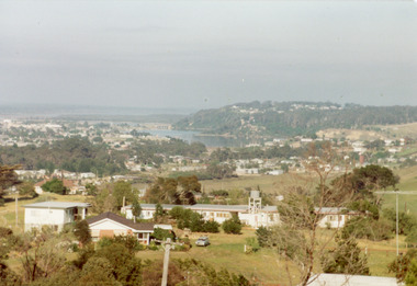
Photograph, Tambo Shire, 1990c
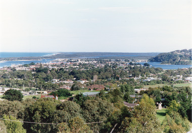
Also second copy photographic enlargements of significant sites in the Tambo ShireColor photograph of the township, showing a distant view of the Ninety Mile Beach, the Gippsland Lakes and islands, Kalimna Heights, the bridge over the North Arm, Cunninghame Arm, and a broad view of the town and tree lined streets. Lakes Entrance Victoriabridges, topography, township, waterways -
 Lakes Entrance Regional Historical Society (operating as Lakes Entrance History Centre & Museum)
Photograph, Fish Marie, 1985c
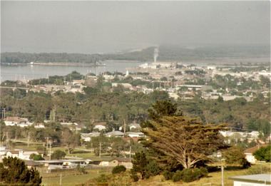
Colour photograph of township, showing building on Bullock Island, Cunningham Arm and small white shed on old New Works Jetty near the entrance, view towards the barrier. Photo taken from near telecom tower on Merrangbaur Hill 1985c. Lakes Entrance Victoriatopography, township, waterways, bridges -
 Lakes Entrance Regional Historical Society (operating as Lakes Entrance History Centre & Museum)
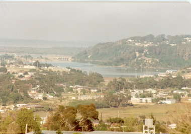
Photograph, Fish, Marie, 1985c
Colour photograph of township, showing buildings, Jemmys Point, Mount Barkly, Kalimna Heights, North Arm and old North Arm bridge, and Rigby Island beyond. Sea Vista flats in foreground. Photo taken from near Telecom Tower on Merrangbaur Hill. Lakes Entrance Victoriatopography, township, waterways, bridges -
 Lakes Entrance Regional Historical Society (operating as Lakes Entrance History Centre & Museum)
Photograph, Fish, Marie, 1985c
Colour photograph of part of township showing Jemmys Point, Mount Barkly, Kalimna Heights, North Arm & old North Arm bridge, looking beyond to Rigby Island. Photo taken from near Telecom Tower on Merrangbaur Hill. Lakes Entrance Victoriatopography, township, waterways, bridges -
 Lakes Entrance Regional Historical Society (operating as Lakes Entrance History Centre & Museum)
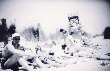
Photograph, Scarce, Heather, 1960c
Spotting tower for lifesaving club built 1937cBlack and white photograph of eight people, some in bathing costumes, sitting on the sand hummock. Showing the observation tower in background. Tower built for Royal Lifesaving Club. Lakes Entrance Victoriaassociations, waterfront, people, topography -
 Lakes Entrance Regional Historical Society (operating as Lakes Entrance History Centre & Museum)
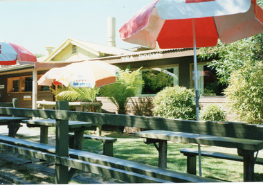
Photograph, Fish Marie, 1990c
Colour photograph of the kiosk on the hummocks. It shows the kiosk with enlarged dining room, garden with rustic picnic tables and seats and three open colored sun umbrellas. Lakes Entrance Victoriatopography, waterfront, township, boats and boating -
 Lakes Entrance Regional Historical Society (operating as Lakes Entrance History Centre & Museum)
Photograph, Tambo Shire, 1980c
This is the before paired photograph used in the 150 year Lakes Entrance 1858-2008 display.|The after paired photograph number is 01544.1|Also one 12 x 16 framed photograph used in room display.Colour photograph of the kiosk on the hummocks. It shows the recently renovated and extended kiosk and garden, nestling beside the scrub covered sand hummock. Rustic picnic tables and seats inside garden grounds. Lakes Entrance Victoriawaterfront, topography, boats and boating, animals -
 Lakes Entrance Regional Historical Society (operating as Lakes Entrance History Centre & Museum)
Photograph, 1937
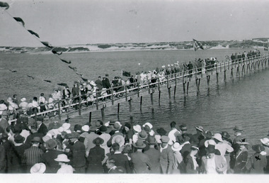
2 other copies existBlack and white photograph of the crowd following Melbourne Lifesavers across footbridge after the official opening in 1937, sand hummocks of southern shore in background. Lakes Entrance Victoriaroads and streets, transport, fences, topography -
 Lakes Entrance Regional Historical Society (operating as Lakes Entrance History Centre & Museum)
Photograph, 1920c
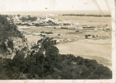
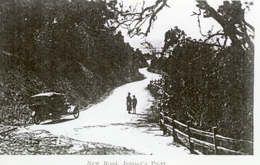
Black and white photograph of the newly formed Princes Highway. It shows the steep cutting into the Jemmys Point hill, the winding road, the post and rail fence, two people and car of the era on road. Lakes Entrance VictoriaNew Road Jemmy's Pointtopography, waterways, roads and streets, fences -
 Lakes Entrance Regional Historical Society (operating as Lakes Entrance History Centre & Museum)
Photograph, Valentine Series, 1920c
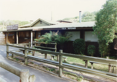
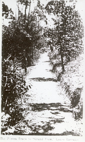
Black and white photograph of the track through natural vegetation to Grand View Guesthouse and Tea Rooms on Kalimna escarpment, Lakes Entrance Victoria.The Beaten Track to Grand View, Lakes Entranceislands, public works, topography, waterways -
 Lakes Entrance Regional Historical Society (operating as Lakes Entrance History Centre & Museum)
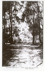
Photograph, 1920c
Black and white photograph of Hazel Walk and Tea Rooms at Kalimna. It shows bush track through natural vegetation leading to rustic weather board with canvas awning on the veranda side of tea rooms. Lakes Entrance VictoriaHazel Walk and Tearooms, Lakes Entranceislands, public works, waterways, topography -
 Lakes Entrance Regional Historical Society (operating as Lakes Entrance History Centre & Museum)
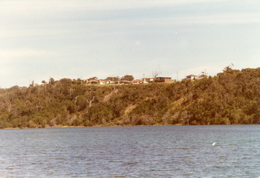
Photograph, Fraser Nancy, 1980c
Colour photograph of private residences on the Kalimna escarpment. It shows houses above a timbered cliff at the northern shore of the North Arm of the lake, bare areas on cliff side indicating recent land slide. Lakes Entrance VictoriaHouses Seaview Parade Kalimna North Arm Lakes Entrance (on back)islands, topography, waterways, public works -
 Lakes Entrance Regional Historical Society (operating as Lakes Entrance History Centre & Museum)
Postcard, Valentine Series, 1895c
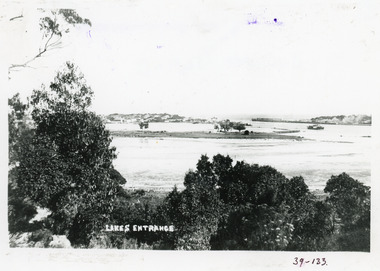
Also a Black and white copy 11.5 x 18Colour tinted postcard of the entrance from Bass Strait to the Gippsland Lakes. It shows two small buildings on Bullock Island, groyne from Bullock Island across Cunninghame arm, sand inside entrance at western pier. Lakes Entrance VictoriaLakes Entrance from Jemmys Pointislands, ships and shipping, topography, waterways -
 Lakes Entrance Regional Historical Society (operating as Lakes Entrance History Centre & Museum)
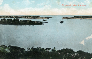
Photograph, 1910c
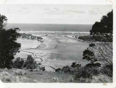
Colour tinted photograph of the entrance from Bass Strait to the Gippsland Lakes. It shows the small village on the hummocks, Bullock Island with bathing boxes at western end, machinery building groyne's from Bullock Island. Boat in the water. Lakes Entrance VictoriaGippsland Lakes Entranceislands, ships and shipping, topography, waterways -
 Lakes Entrance Regional Historical Society (operating as Lakes Entrance History Centre & Museum)
Postcard, Cooper Alexander, 1910c
Black and white large format postcard of the man made entrance to the Gippsland Lakes, it shows work in progress on the western pier of the entrance, Bullock Island, photo taken at low tide. Lakes Entrance VictoriaLakes Entrance Cunninghameislands, waterways, topography, ships and shipping -
 Lakes Entrance Regional Historical Society (operating as Lakes Entrance History Centre & Museum)
Photograph
Black and white photograph of Bullock Island. Steamer J C D passing Western end of Bullock Island. Lakes Entrance VictoriaLakes Entrancewaterways, islands, township, topography -
 Lakes Entrance Regional Historical Society (operating as Lakes Entrance History Centre & Museum)
Photograph, 1922c
Black and white copy 9.5 x 15|Black and white copy 12x18Black and white photograph of the entrance and Bullock Island. It shows the western end of Bullock Island with bathing boxes, rock groynes, and sandy shore beneath Jemmys Point. Lakes Entrance VictoriaLakes Entrance, Gippsland Lakesislands, waterways, bridges, topography -
 Lakes Entrance Regional Historical Society (operating as Lakes Entrance History Centre & Museum)
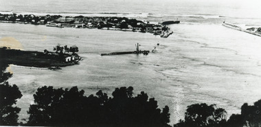
Photograph, Martin Orville, 1940c
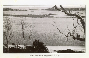
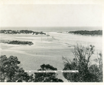
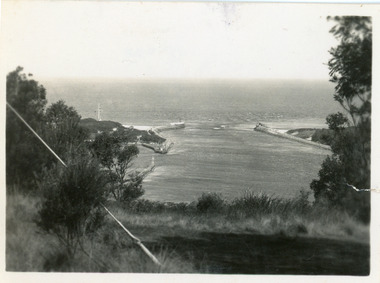
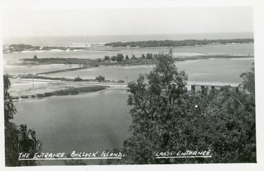
Another copy Black and white 7 x 8.5 with inscription'View showing the Entrance, Lakes Entrance, Vic'Black and white photograph of Bullock Island, the New Works, township and entrance from Bass Strait to the Gippsland Lakes. Taken at high tide. Lakes Entrance Victoriaislands, waterways, bridges, topography -
 Lakes Entrance Regional Historical Society (operating as Lakes Entrance History Centre & Museum)
Postcard, 1920c
1 x Faded miniature postcard 6.5 x 8.5|1 x Black and white 9.5 x 12 copied from album in private hands|1 x Sepia toned 10 x 15|1 x Black and white 12 x 17.5Black and white small format postcard of Bullock Island. It shows the approaches to the concrete North Arm Bridge over North Arm, the footbridge to Bullock Island, the entrance to the Gippsland Lakes from Bass Strait and part of the township on the hummocks. Lakes Entrance VictoriaLakes Entrancewaterways, topography, islands, jetties -
 Lakes Entrance Regional Historical Society (operating as Lakes Entrance History Centre & Museum)
Photograph, 1930c
Black and white photograph showing wooden piers at entrance to Bass Strait from the Gippsland Lakes. Buildings on sand dunes, Bullock Island and rock groynes. Photo taken from Jemmys Point showing shrubbery in foreground. Lakes Entrance Victoriawaterways, topography, boats and boating, islands -
 Lakes Entrance Regional Historical Society (operating as Lakes Entrance History Centre & Museum)
Photograph, 1930c
Black and white photograph showing wooden piers at entrance to Bass Strait from the Gippsland Lakeswaterways, topography, boats and boating, islands -
 Lakes Entrance Regional Historical Society (operating as Lakes Entrance History Centre & Museum)
Photograph, 1930c
Black and white photograph showing wooden piers at entrance to Bass Strait from the Gippsland Lakeswaterways, topography, boats and boating, islands -
 Lakes Entrance Regional Historical Society (operating as Lakes Entrance History Centre & Museum)
Photograph, 1930c
Black and white photograph showing wooden piers at entrance to Bass Strait from the Gippsland Lakeswaterways, topography, boats and boating, islands -
 Lakes Entrance Regional Historical Society (operating as Lakes Entrance History Centre & Museum)
Postcard, The Lakes Studio, 1920c
One black and white copy 17 x 25Black and white postcard showing North Arm Bridge, Bullock Island and foot bridge northern end of piers at entrance to Bass Strait and sand dunes. Left foreground shows power pole and water bore and telephone poles along Princes Highway Lakes Entrance Victoria.The Entrance, Bullock Island, Lakes Entranceislands, bridges, waterways, topography