Showing 359 items matching "victorian photographer"
-
 Kew Historical Society Inc
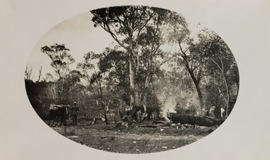
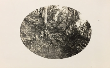
Photograph - Campsite near Bogong, c.1926
Henry Beater Christian (1886-1962) , was a descendant of one of the earliest settler families in Kew. Employed at the Kew Asylum as a 'public servant', he was a skilled amateur photographer, photographing numerous scenes in Kew and on his travels around Victoria. The majority of his photographs date from 1916 to 1929. His finest photographs are housed in two photograph albums. Digital copy of a photograph from page 34 of the 47-page photograph album containing 261 gelatinous silver images, loaned by Diane Washfold with permission given to digitise and hold a copy in our collection. John Chapman has written in 'Bushwalking Clubs - A Brief History', about the establishment in Victoria of the first bushwalking club in 1888, and the popularisation of bushwalking during the interwar period. Henry Christian's 'walks' appear to have been undertaken solely or with a companion/s. This black and white photo is part of a group of photos taken in the Victorian High Country. The page is labelled 'Bogong ****' and includes photos of landscapes, individuals, and built structures. This evocative, small black and white photo is of a campsite near Bogong in Victoria in the mid-1920s. Enclosed in an oval shape, which the photographer clearly used for what he considered his best images, the photograph includes pack and saddled horses and travellers."BOGONG [illegible]"henry beater christian (1886-1962), landscape photography, christian-washfold collection, photograph albums, bushwalking, northeast victoria, victorian high country, bogong -
 Kew Historical Society Inc
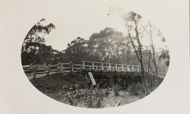
Photograph - Bridge near Bogong, c.1926
Henry Beater Christian (1886-1962) , was a descendant of one of the earliest settler families in Kew. Employed at the Kew Asylum as a 'public servant', he was a skilled amateur photographer, photographing numerous scenes in Kew and on his travels around Victoria. The majority of his photographs date from 1916 to 1929. His finest photographs are housed in two photograph albums. Digital copy of a photograph from page 34 of the 47-page photograph album containing 261 gelatinous silver images, loaned by Diane Washfold with permission given to digitise and hold a copy in our collection. John Chapman has written in 'Bushwalking Clubs - A Brief History', about the establishment in Victoria of the first bushwalking club in 1888, and the popularisation of bushwalking during the interwar period. Henry Christian's 'walks' appear to have been undertaken solely or with a companion/s. This black and white photo is part of a group of photos taken in the Victorian High Country. The page is labelled 'Bogong ****' and includes photos of landscapes, individuals, and built structures. This small black and white photo is of a wooden bridge near Bogong in Victoria in the mid-1920s."BOGONG [illegible]"henry beater christian (1886-1962), landscape photography, christian-washfold collection, photograph albums, bushwalking, northeast victoria, victorian high country, bogong -
 Kew Historical Society Inc
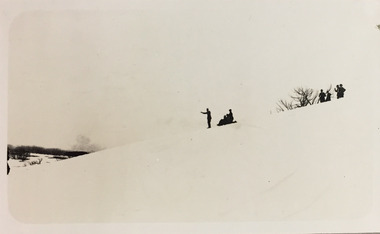
Photograph - Winter sports near Bogong, c.1926
Henry Beater Christian (1886-1962) , was a descendant of one of the earliest settler families in Kew. Employed at the Kew Asylum as a 'public servant', he was a skilled amateur photographer, photographing numerous scenes in Kew and on his travels around Victoria. The majority of his photographs date from 1916 to 1929. His finest photographs are housed in two photograph albums. Digital copy of a photograph from page 34 of the 47-page photograph album containing 261 gelatinous silver images, loaned by Diane Washfold with permission given to digitise and hold a copy in our collection. John Chapman has written in 'Bushwalking Clubs - A Brief History', about the establishment in Victoria of the first bushwalking club in 1888, and the popularisation of bushwalking during the interwar period. Henry Christian's 'walks' appear to have been undertaken solely or with a companion/s. This black and white photo is part of a group of photos taken in the Victorian High Country. The page is labelled 'Bogong ****' and includes photos of landscapes, individuals, and built structures. This small black and white photo is of individuals and groups skiing and toboganning near Bogong in Victoria in the mid-1920s."BOGONG [illegible]"henry beater christian (1886-1962), landscape photography, christian-washfold collection, photograph albums, bushwalking, northeast victoria, victorian high country, bogong -
 Kew Historical Society Inc
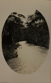
Photograph - Snow-covered road near Bogong, c.1926
Henry Beater Christian (1886-1962) , was a descendant of one of the earliest settler families in Kew. Employed at the Kew Asylum as a 'public servant', he was a skilled amateur photographer, photographing numerous scenes in Kew and on his travels around Victoria. The majority of his photographs date from 1916 to 1929. His finest photographs are housed in two photograph albums. Digital copy of a photograph from page 34 of the 47-page photograph album containing 261 gelatinous silver images, loaned by Diane Washfold with permission given to digitise and hold a copy in our collection. John Chapman has written in 'Bushwalking Clubs - A Brief History', about the establishment in Victoria of the first bushwalking club in 1888, and the popularisation of bushwalking during the interwar period. Henry Christian's 'walks' appear to have been undertaken solely or with a companion/s. This black and white photo is part of a group of photos taken in the Victorian High Country. The page is labelled 'Bogong ****' and includes photos of landscapes, individuals, and built structures. This small black and white photo is of what appears to be a snow-covered track or road near Bogong in Victoria in the mid-1920s."BOGONG [illegible]"henry beater christian (1886-1962), landscape photography, christian-washfold collection, photograph albums, bushwalking, northeast victoria, victorian high country, bogong -
 Kew Historical Society Inc
Photograph - Trekking near Bogong, c.1926
Henry Beater Christian (1886-1962) , was a descendant of one of the earliest settler families in Kew. Employed at the Kew Asylum as a 'public servant', he was a skilled amateur photographer, photographing numerous scenes in Kew and on his travels around Victoria. The majority of his photographs date from 1916 to 1929. His finest photographs are housed in two photograph albums. Digital copy of a photograph from page 34 of the 47-page photograph album containing 261 gelatinous silver images, loaned by Diane Washfold with permission given to digitise and hold a copy in our collection. John Chapman has written in 'Bushwalking Clubs - A Brief History', about the establishment in Victoria of the first bushwalking club in 1888, and the popularisation of bushwalking during the interwar period. Henry Christian's 'walks' appear to have been undertaken solely or with a companion/s. This black and white photo is part of a group of photos taken in the Victorian High Country. The page is labelled 'Bogong ****' and includes photos of landscapes, individuals, and built structures. This small black and white photo shows a group of trekkers on horseback near Bogong in Victoria in the mid-1920s."BOGONG [illegible]"henry beater christian (1886-1962), landscape photography, christian-washfold collection, photograph albums, bushwalking, northeast victoria, victorian high country, bogong -
 Kew Historical Society Inc
Photograph - Sunnyside and Mt Wills, c.1926
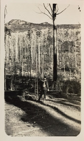
Henry Beater Christian (1886-1962) , was a descendant of one of the earliest settler families in Kew. Employed at the Kew Asylum as a 'public servant', he was a skilled amateur photographer, photographing numerous scenes in Kew and on his travels around Victoria. The majority of his photographs date from 1916 to 1929. His finest photographs are housed in two photograph albums. Digital copy of a photograph from page 35 of the 47-page photograph album containing 261 gelatinous silver images, loaned by Diane Washfold with permission given to digitise and hold a copy in our collection. John Chapman has written in 'Bushwalking Clubs - A Brief History', about the establishment in Victoria of the first bushwalking club in 1888, and the popularisation of bushwalking during the interwar period. Henry Christian's 'walks' appear to have been undertaken solely or with a companion/s. This black and white photo is part of a group of photos taken in the Victorian High Country. The page is labelled 'Mt Wills / Sunnyside' and includes photos of landscapes and built structures. Mt Wills and Sunnyside were at the time goldfields north of Omeo. This small black and white point-of-view photograph shows the photographer, Henry B Christian, staring across a treed landscape to Mt Wills in the distance."MT WILLS / SUNNYSIDE"henry beater christian (1886-1962), landscape photography, christian-washfold collection, photograph albums, bushwalking, northeast victoria, victorian high country, mt wills, sunnyside -
 Kew Historical Society Inc
Plan - Subdivision Plan, Corsewall Estate, Hawthorn, 1938
The Kew Historical Society collection includes almost 100 subdivision plans pertaining to suburbs of the City of Melbourne. Most of these are of Kew, Kew East or Studley Park, although a smaller number are plans of Camberwell, Deepdene, Balwyn and Hawthorn. It is believed that the majority of the plans were gifted to the Society by persons connected with the real estate firm - J. R. Mathers and McMillan, 136 Cotham Road, Kew. The Plans in the collection are rarely in pristine form, being working plans on which the agent would write notes and record lots sold and the prices of these. The subdivision plans are historically significant examples of the growth of urban Melbourne from the beginning of the 20th Century up until the 1980s. A number of the plans are double-sided and often include a photograph on the reverse. A number of the latter are by noted photographers such as J.E. Barnes.This is a second, more complete version of the Corsewall Estate subdivision that is held by the Society. The Coreswall Estate was a subdivision, bordering on Barkers Road and Auburn Road, which created Corsewall Close. This relatively late subdivision included 29 allotments. The subdivision plan includes the dimensions of each lot as well as the width of the existing and projected roads and turning circles. The Corsewall Close Precinct is now listed on the Victorian Heritage Database (HO147) and is noted for its ‘consistent flat-type development over the entire street, which has been cleverly designed to make multi-unit dwellings appear as single buildings’. In this second version of the plan, the rarity of this late subdivision is emphasised by the auctioneers. The original plan must have contained a photograph, which is unfortunately truncated here.subdivision plans - hawthorn, corsewall estate -
 Kew Historical Society Inc
Plan - Subdivision Plan, Corsewall Estate, 1938
The Kew Historical Society collection includes almost 100 subdivision plans pertaining to suburbs of the City of Melbourne. Most of these are of Kew, Kew East or Studley Park, although a smaller number are plans of Camberwell, Deepdene, Balwyn and Hawthorn. It is believed that the majority of the plans were gifted to the Society by persons connected with the real estate firm - J. R. Mathers and McMillan, 136 Cotham Road, Kew. The Plans in the collection are rarely in pristine form, being working plans on which the agent would write notes and record lots sold and the prices of these. The subdivision plans are historically significant examples of the growth of urban Melbourne from the beginning of the 20th Century up until the 1980s. A number of the plans are double-sided and often include a photograph on the reverse. A number of the latter are by noted photographers such as J.E. Barnes.The Corsewall Estate was a subdivision, bordering on Barkers Road and Auburn Road, which created Corsewall Close. This relatively late subdivision included 29 allotments. The subdivision plan includes the dimensions of each lot as well as the width of the existing and projected roads and turning circles. The Corsewall Close Precinct is now listed on the Victorian Heritage Database (HO147) and is noted for its ‘consistent flat-type development over the entire street, which has been cleverly designed to make multi-unit dwellings appear as single buildings’.subdivision plans - hawthorn, corsewall estate -- hawthorn (vic.) -
 Kew Historical Society Inc
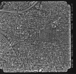
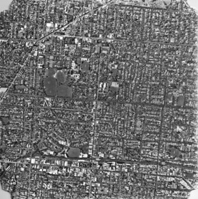
Photograph - Aerial photograph: City of Kew No.1/6, Department of Property & Services (Victoria), 12/12/1987
... Aerial photograph of a part of Kew, taken by photographers..., taken by photographers employed by the Victorian Department ...One of a series of six small square black and white aerial photographs of Kew taken and produced by the Victorian Department of Property Services.Aerial photographs, of which the Society has a number in its collection, allow researchers to identify changes in urban infrastructure and demographics over timeAerial photograph of a part of Kew, taken by photographers employed by the Victorian Department of Property and Services in December 1987.4132-106 Ringwood M'Sheet 7922-3 Run 4 5600'ASL Vic DPS © 12-12-87aerial photography, aerial photograph -- kew (vic.) -
 Kew Historical Society Inc
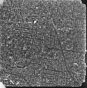
Photograph, Department of Property & Services (Victoria), City of Kew No.2/6, 12/12/1987
... Aerial photograph of a part of Kew, taken by photographers... of Kew taken and produced by the Victorian Department of Property ...One of a series of six small square black and white aerial photographs of Kew taken and produced by the Victorian Department of Property Services.Aerial photographs, of which the Society has a number in its collection, allow researchers to identify changes in urban infrastructure and demographics over timeAerial photograph of a part of Kew, taken by photographers employed by the Victorian Department of Property and Services in December 1987.aerial photograph - kew -
 Kew Historical Society Inc
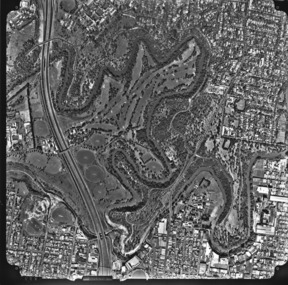
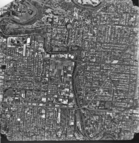
Photograph, Department of Property & Services (Victoria), City of Kew No.3/6, 12/12/1987
... Aerial photograph of a part of Kew, taken by photographers... of Kew taken and produced by the Victorian Department of Property ...One of a series of six small square black and white aerial photographs of Kew taken and produced by the Victorian Department of Property Services.Aerial photographs, of which the Society has a number in its collection, allow researchers to identify changes in urban infrastructure and demographics over timeAerial photograph of a part of Kew, taken by photographers employed by the Victorian Department of Property and Services in December 1987.aerial photograph - kew, aerial photographs -
 Kew Historical Society Inc
Photograph, Department of Property & Services (Victoria), City of Kew No.4/6, 12/12/1987
... Aerial photograph of a part of Kew, taken by photographers... of Kew taken and produced by the Victorian Department of Property ...One of a series of six small square black and white aerial photographs of Kew taken and produced by the Victorian Department of Property Services.Aerial photographs, of which the Society has a number in its collection, allow researchers to identify changes in urban infrastructure and demographics over timeAerial photograph of a part of Kew, taken by photographers employed by the Victorian Department of Property and Services in December 1987.aerial photograph - kew, aerial photographs -
 Kew Historical Society Inc
Photograph, Department of Property & Services (Victoria), City of Kew, No.5/6, 12/12/1987
... Aerial photograph of a part of Kew, taken by photographers... of Kew taken and produced by the Victorian Department of Property ...One of a series of six small square black and white aerial photographs of Kew taken and produced by the Victorian Department of Property Services.Aerial photographs, of which the Society has a number in its collection, allow researchers to identify changes in urban infrastructure and demographics over timeAerial photograph of a part of Kew, taken by photographers employed by the Victorian Department of Property and Services in December 1987.aerial photograph - kew, aerial photographs -
 Kew Historical Society Inc
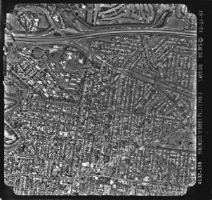
Photograph, Department of Property & Services (Victoria), City of Kew, No.6/6, 12/12/1987
... Aerial photograph of a part of Kew, taken by photographers... by photographers employed by the Victorian Department of Property ...One of a series of six small square black and white aerial photographs of Kew taken and produced by the Victorian Department of Property Services.Aerial photographs, of which the Society has a number in its collection, allow researchers to identify changes in urban infrastructure and demographics over timeAerial photograph of a part of Kew, taken by photographers employed by the Victorian Department of Property and Services in December 1987.4312-108 Ringwood M'Sheet 7922-3 Run 4 5600'ASL Vic DPS © 12-12-87aerial photograph - kew, aerial photographs -
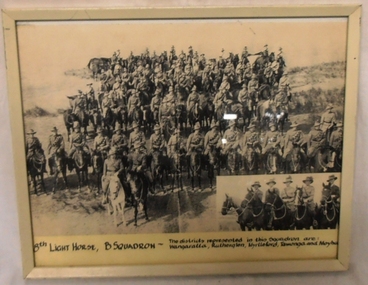 8th/13th Victorian Mounted Rifles Regimental Collection
Photograph, 8th Light Horse B. Squadron, 1940
This photograph is likely to have been taken by a newspaper photographer when visiting the 8th Light Horse Regiment on manoeuvres with the 2nd Cavalry Division at Torquay Victoria in 1940. This assumption is supported by the identification of the districts from which the soldiers are drawn. The Fine studies of citizen soldiers while on manoeuvres in the period immediately preceding phasing out of horses and the transition to mechanised transport.Framed black and white photograph of sixty mounted light horsemen drawn up in massed ranks on a sand hill. Small insert photograph of five light horsemen, probably the squadron officers in lower right corner."8th Light Horse B. Squadron. The districts represented in this Squadron are Wangaratta, Rutherglen, Myrtleford, Tawonga and Moyhu"8th light horse regiment, wangaratta, rutherglen, myrtleford, tawonga, moyhu -
 Kew Historical Society Inc
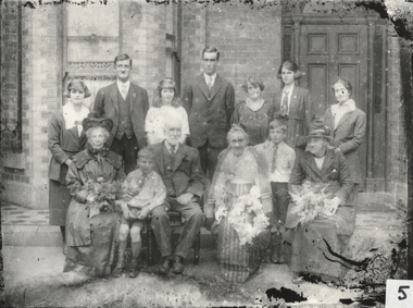
Photograph, Family Group, c.1910
This photograph was printed from a glass negative held in the Society's picture collection. The original glass negative is part of a set donated to the Society by Ian McKenzie, a professional photographer in Kew. Portrait of a family. Thirteen members of what is perhaps a family group comprised of multiple generations pose at the front of a house for a group portrait. The clothing worn by individuals in the photo range from the late Victorian period to that current when the photograph was taken. family portraits, glass negatives -
 Kew Historical Society Inc
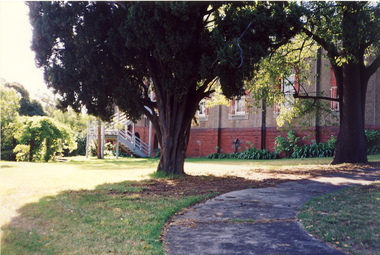
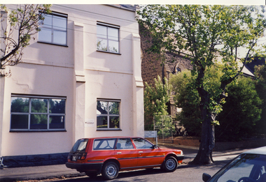
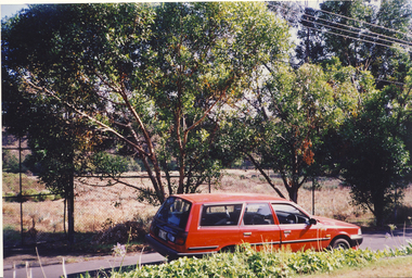
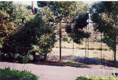
Photograph, Former Convent of the Good Shepherd, Abbotsford
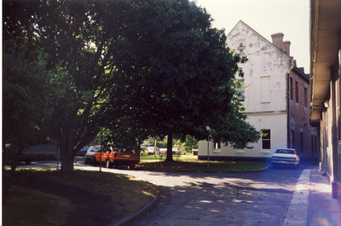
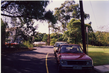
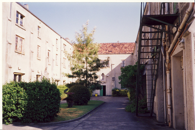
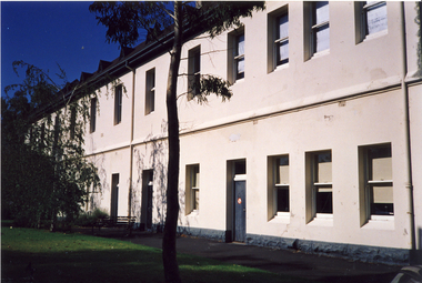
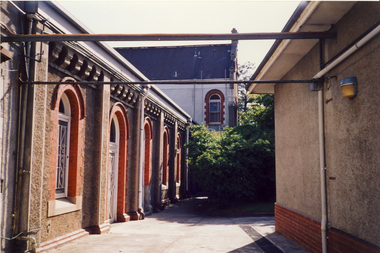
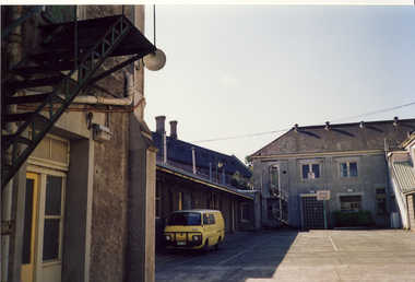
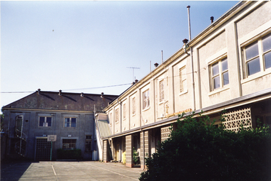
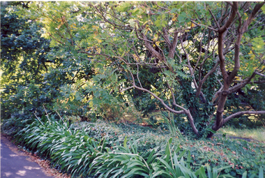
The former Convent of the Good Shepherd at Abbotsford includes ecclesiastical, residential, educational and utility buildings constructed during the late nineteenth and twentieth centuries on a bend of the Yarra River. In 1975 the site was purchased by the Victorian Government as a higher education campus. A proposed redevelopment of the site in the late 1990s led to a community-based heritage battle which resulted in 2004 in the transfer of the convent site south of St Heliers Street to the Abbotsford Convent Foundation for community use. (Source: Heritage Victoria)This photograph is part of a series taken c.1990 by the photographer Rick Lowell. It was taken before the heritage campaign to preserve the site for community use.Colour snapshot of a part or section of the Former Convent of the Good Shepherd, Abbotsfordconvent of the good shepherd, abbotsford -
 Kew Historical Society Inc
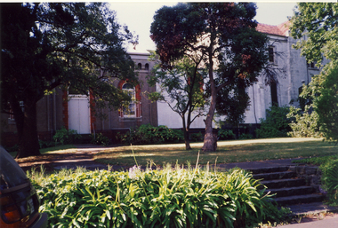
Photograph, Former Convent of the Good Shepherd, Abbotsford
The former Convent of the Good Shepherd at Abbotsford includes ecclesiastical, residential, educational and utility buildings constructed during the late nineteenth and twentieth centuries on a bend of the Yarra River. In 1975 the site was purchased by the Victorian Government as a higher education campus. A proposed redevelopment of the site in the late 1990s led to a community-based heritage battle which resulted in 2004 in the transfer of the convent site south of St Heliers Street to the Abbotsford Convent Foundation for community use. (Source: Heritage Victoria)This photograph is part of a series taken c.1990 by the photographer Rick Lowell. It was taken before the heritage campaign to preserve the site for community use.Colour snapshot of a part or section of the Former Convent of the Good Shepherd, Abbotsford by Rick Lovell.abbotsford convent -
 Kew Historical Society Inc
Photograph, Former Convent of the Good Shepherd, Abbotsford
The former Convent of the Good Shepherd at Abbotsford includes ecclesiastical, residential, educational and utility buildings constructed during the late nineteenth and twentieth centuries on a bend of the Yarra River. In 1975 the site was purchased by the Victorian Government as a higher education campus. A proposed redevelopment of the site in the late 1990s led to a community-based heritage battle which resulted in 2004 in the transfer of the convent site south of St Heliers Street to the Abbotsford Convent Foundation for community use. (Source: Heritage Victoria)This photograph is part of a series taken c.1990 by the photographer Rick Lowell. It was taken before the heritage campaign to preserve the site for community use.Colour snapshot of a part or section of the Former Convent of the Good Shepherd, Abbotsford by the photographer Rick Lowell.abbotsford convent -
 Kew Historical Society Inc
Photograph, Former Convent of the Good Shepherd, Abbotsford
The former Convent of the Good Shepherd at Abbotsford includes ecclesiastical, residential, educational and utility buildings constructed during the late nineteenth and twentieth centuries on a bend of the Yarra River. In 1975 the site was purchased by the Victorian Government as a higher education campus. A proposed redevelopment of the site in the late 1990s led to a community-based heritage battle which resulted in 2004 in the transfer of the convent site south of St Heliers Street to the Abbotsford Convent Foundation for community use. (Source: Heritage Victoria)This photograph is part of a series taken c.1990 by the photographer Rick Lowell. It was taken before the heritage campaign to preserve the site for community use.Colour snapshot of a part or section of the Former Convent of the Good Shepherd, Abbotsfordabbotsford convent -
 Kew Historical Society Inc
Photograph, Former Convent of the Good Shepherd, Abbotsford
The former Convent of the Good Shepherd at Abbotsford includes ecclesiastical, residential, educational and utility buildings constructed during the late nineteenth and twentieth centuries on a bend of the Yarra River. In 1975 the site was purchased by the Victorian Government as a higher education campus. A proposed redevelopment of the site in the late 1990s led to a community-based heritage battle which resulted in 2004 in the transfer of the convent site south of St Heliers Street to the Abbotsford Convent Foundation for community use. (Source: Heritage Victoria)This photograph is part of a series taken c.1990 by the photographer Rick Lowell. It was taken before the heritage campaign to preserve the site for community use.Colour snapshot of a part or section of the Former Convent of the Good Shepherd, Abbotsfordabbotsford convent, convent of the good shepherd, abbotsford (vic.) -
 Kew Historical Society Inc
Photograph, Former Convent of the Good Shepherd, Abbotsford
The former Convent of the Good Shepherd at Abbotsford includes ecclesiastical, residential, educational and utility buildings constructed during the late nineteenth and twentieth centuries on a bend of the Yarra River. In 1975 the site was purchased by the Victorian Government as a higher education campus. A proposed redevelopment of the site in the late 1990s led to a community-based heritage battle which resulted in 2004 in the transfer of the convent site south of St Heliers Street to the Abbotsford Convent Foundation for community use. (Source: Heritage Victoria)This photograph is part of a series taken c.1990 by the photographer Rick Lowell. It was taken before the heritage campaign to preserve the site for community use.Colour snapshot of a part or section of the Former Convent of the Good Shepherd, Abbotsfordabbotsford convent, convent of the good shepherd, abbotsford (vic.)