Showing 6931 items matching "view street"
-
 Melbourne Tram Museum
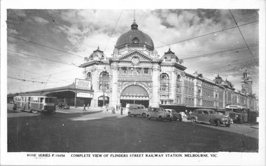
Postcard, Rose Stereograph Co, "Complete view of Flinders Street Railway Station, Melbourne", early 1940s
... "Complete view of Flinders Street Railway Station...Rose Series postcard No. P 10456 titled "Complete view.... "Complete view of Flinders Street Railway Station, Melbourne ...Rose Series postcard No. P 10456 titled "Complete view of Flinders Street Railway Station, Melbourne", looking from St Paul's Cathedral steps. Two W2 class trams in Swanston Street, one fitted with a white dash panel under the driver's windows indicating a wartime black-out precautions era. There is an MMTB TS8c or TS11c bus eastbound in Flinders Street bound for "Kew" (Kew Junction). There are some cars waiting to complete their hook turns into Flinders Street. There is an advertisement on the station for the Women's Auxiliary Australian Air Force (WAAAF) this organisation was founded in 1941.Yields information about Flinders St station early 1940s.Postcard - printed real photograph with Rose Stereograph Co. name on the rear.trams, tramways, w2 class, swanston st, flinders st station, flinders st, buses, mmtb buses, ts8c class, world war ii -
 Ballarat Tramway Museum
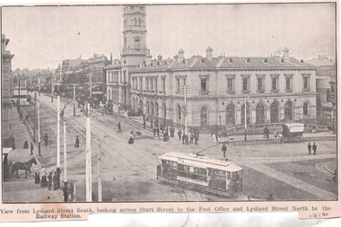
Photograph - Illustration, WTP, "View from Lydiard Street South looking across Sturt St", c1907
... "View from Lydiard Street South looking across Sturt St"... of the photograph. The caption along the bottom edge "View from Lydiard... "View from Lydiard Street South looking across Sturt St ...Illustration of the intersection of Sturt St and Lydiard St Nth with the Ballarat Post Office being the primary feature. Has an ESCo tram turning from Sturt St into Lydiard St. Shows the trackwork at this location and has several horse-drawn vehicles in the photograph. Note the building in the road space on the left-hand side of the photograph. The caption along the bottom edge "View from Lydiard Street South looking across Sturt Street to the Post Office and Lydiard Street North to the Railway Station. On the rear has an item about Ballarat itself and its history. See also item 6245 for a postcard of this view. Yields information about the post office corner at the time of the opening of the tramway and demonstrates printing techniques.Black and white Illustration cut from a journaltramways, trams, sturt st, esco, post office, lydiard st north -
 Linton and District Historical Society Inc
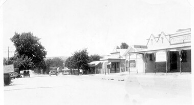
Photograph, Sussex Street, Linton - view to north, late 1920s or early 1930s
... Sussex Street, Linton - view to north, late 1920s or early... Street. View of Railway Hotel, Nelson undertaker building, public... of Linton's main street, Sussex Street. View of Railway Hotel, Nelson ...Dated to late 1920s or early 1930s as Nelson building has been renovated as a Californian bungalow. The earlier curvilinear parapet on the library building (see photo - Registration no. 166) has been squared off, and a small pedimented timber parapet has been added above.Black and white photograph of Linton's main street, Sussex Street. View of Railway Hotel, Nelson undertaker building, public library and "cash emporium". Cars parked and driving along Sussex St."Linton Main Street".sussex street linton, railway hotel, nelson undertakers, linton public library, cash emporium, transport, cars -
 Linton and District Historical Society Inc
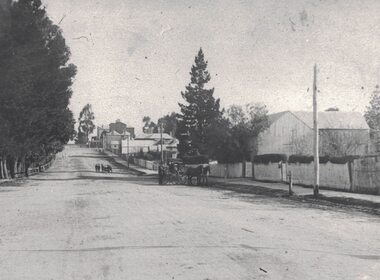
Photograph, View along Sussex Street, Linton, circa 1920
... View along Sussex Street, Linton, circa 1920 ... houses and other buildings along Sussex Street. The view... and other buildings along Sussex Street. The view is to the south ...Dr Donaldson (Snr) owned the block of land on the corner of Sussex and Grant Streets, Linton. He had a ten-room house set on the back of the block (where the block backs on to Surrey Street), with a large barn fronting Sussex Street. Other identifiable buildings in the photograph are Ball Brothers blacksmith's shop, the Royal Standard Hotel on the corner of Sussex and Clyde Streets, the Shire Hall, Criterion House and Joseph Shepherd's store. The roof of Oscar Ball's house can be seen.Black and white copy of original photograph which shows houses and other buildings along Sussex Street. The view is to the south (up the hill) from the Ballarat entrance to Linton. A large barn, enclosed by a picket fence, is in the foreground. A cart drawn by two horses, with a man standing next to it, is in the street near the barn. Further along the street, a group of people appear to be wheeling a barrow or cart. Houses and other buildings can be seen along the street.sussex street linton, dr donaldson's barn, ball bros. blacksmith, royal standard hotel, shire of grenville offices linton, criterion house, joseph shepherd's store -
 Surrey Hills Historical Society Collection
Photograph, Subdivision sale of Black's Mont Albert farm in 1924, 1924
... street, view street, neil black, proudfoot & horton, duncan... Street and View Street. The solicitors were Proudfoot & Horton..., Proudfoot Street and View Street. The solicitors were Proudfoot ...Photo was taken in 1924 when the land was subdivided. Black's dairy farm occupied the area just east of Hamilton Street to near Elgar Road. It was subdivided into 88 house allotments along Churchill Street, Bruce Street, Black Street, Proudfoot Street and View Street. The solicitors were Proudfoot & Horton, 360 Collins Street; estate agents were Duncan & Weller, 29 Queen Street. The real estate subdivision notice on the SLV website states that Neil Black had been the owner for 50 years. To date no trace of a Neil Black has been found. Box Hill rate books simply give BLACK as the owner in 1877 (no first name); the entry for 1878-1884 states Robert Black. The 1909 electoral roll has entries for Mont Albert Road for Robert Black (farmer), Thomas Black (carter) & Elizabeth Black (HD). The 1912 electoral roll has entries for Mont Albert Road for Robert Black (farmer), Thomas Black (labourer), John Arthur Black (carter) & Elizabeth Black (HD). Robert Black died in 1920 (b. 1836) and is buried in Box Hill Cemetery (CE-*-0057). His parents were John and Margaret Black. He married Lizzie Foley in 1878. She was the daughter of Margaret & John Foley, born in 1859. She died in 1902 aged 43 years and is buried in the same grave, although the cemetery records record her age as 0 years (presumably as no age or date of birth were given at the time of burial). Children: 1. James Hughbert (1880-1954) 2. John Arthur (1881-1959) 3. Alice (1882-1883) - died aged 6 months 4. Laura Elizabeth (1883-1951) 5. Thomas (1885-1965) 6. Isabella (1887-1963) 7. Eleanor (1889-1963) 8. Ada Maud (1890-1968) 9. Robert (1892-1930). BDM Victoria states places of birth as Box Hill, Surrey Hills or Mont Albert. Many of the family are buried in Box Hill Cemetery. None of the girls appear to have married. Communication from a descendant of John Arthur Black gives the following: "John Arthur Black, son of Robert & Lizzie Foley, married Gladys Anne Layton had 4 children, Robert, Elenore, Marion (Follett) & Annie; they had farm on Stud Road, Dandenong where they milked 30 cows that he retired to after being a earth-moving contractor with draft horses and dug irrigation ditches around Shepparton." This is important as documentation of the area's transformation from farming land to residential land use.Black and white photo of a large 3-poled tent in an area of flat land with eucalypts in the background. There is a large crowd of people, mainly men but also women and children. There are also 3 cars to the RHS.black's dairy farm, dairying, farms, churchill street, black street, proudfoot street, bruce street, view street, neil black, proudfoot & horton, duncan & weller, robert black, lizzie black, lizzie foley, james hubert black, john arthur black, alice black, laura elizabeth black, thomas black, isabella black, eleanor black, ada maud black, robert black jnr, box hill cemetery, land sales -
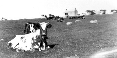 Surrey Hills Historical Society Collection
Photograph, Norman Carter, Part of Black's dairy farm in Mont Albert in the 1920s, 1920s
... street, view street, neil black, proudfoot & horton, duncan..., Black Street, Proudfoot Street and View Street. The solicitors... Street, Black Street, Proudfoot Street and View Street ...Photo is likely to have been taken pre-1924 when the land was subdivided. Donor information is that this was taken from a home in Churchill Street, Mont Albert; it would be looking south towards Mont Albert Road. Black's dairy farm occupied the area just east of Hamilton Street to near Elgar Road. It was subdivided into 88 house allotments along Churchill Street, Bruce Street, Black Street, Proudfoot Street and View Street. The solicitors were Proudfoot & Horton, 360 Collins Street; estate agents were Duncan & Weller, 29 Queen Street. The real estate subdivision notice on the SLV website states that Neil Black had been the owner for 50 years. To date no trace of a Neil Black has been found. Box Hill rate books simply give BLACK as the owner in 1877 (no first name); the entry for 1878-1884 states Robert Black. The 1909 electoral roll has entries for Mont Albert Road for Robert Black (farmer), Thomas Black (carter) & Elizabeth Black (HD). The 1912 electoral roll has entries for Mont Albert Road for Robert Black (farmer), Thomas Black (labourer), John Arthur Black (carter) & Elizabeth Black (HD). Robert Black died in 1920 (b. 1836) and is buried in Box Hill Cemetery (CE-*-0057). His parents were John and Margaret Black. He married Lizzie Foley in 1878. She was the daughter of Margaret & John Foley, born in 1859. She died in 1902 aged 43 years and is probably buried in the same grave, although the cemetery records record her age as 0 years. Children: 1. James Hughbert (1880-1954) 2. John Arthur (1881-1959) 3. Alice (1882-1883) - died aged 6 months 4. Laura Elizabeth (1883-1951) 5. Thomas (1885-1965) 6. Isabella (1887-1963) 7. Eleanor (1889-1963) 8. Ada Maud (1890-1968) 9. Robert (1892-1930). BDM Victoria states places of birth as Box Hill, Surrey Hills or Mont Albert. Many of the family are buried in Box Hill Cemetery. None of the girls appear to have married. Communication from a descendant of John Arthur Black gives the following: "John Arthur Black, son of Robert & Lizzie Foley, married Gladys Anne Layton had 4 children, Robert, Elenore, Marion (Follett) & Annie; they had farm on Stud Road, Dandenong where they milked 30 cows that he retired to after being a earth-moving contractor with draft horses and dug irrigation ditches around Shepparton." This is important as documentation of the area's early farming land use.Black and white photo of a paddock with cows and sheep grazing. On the horizon is a simple cottage with a small veranda and 2 chimneys and scattered trees.black's dairy farm, dairying, farms, churchill street, black street, proudfoot street, bruce street, view street, neil black, proudfoot & horton, duncan & weller, robert black, lizzie black, lizzie foley, james hubert black, john arthur black, alice black, laura elizabeth black, thomas black, isabella black, eleanor black, ada maud black, robert black jnr, box hill cemetery -
 Bendigo Historical Society Inc.
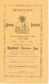
Document - BENDIGO GOLDFIELD - HISTORY OF, FOR MELBOURNE EXHIBITION 1880
... Printer: W. Welch, View Street... Inc. History House 11 Mackenzie Street Bendigo goldfields ...Yellow covered booklet 'History of the Bendigo Goldfield from its commencement in 1851 to June 1881' Presented with the Eaglehawk Specimen Case and giving a description of its contents, for transmission with the said case to England. Dedicated to G.D. Peters, Esq, London, by Mr. Hay Kirkwood, Eaglehawk. Inside first page ( un-numbered) 'The Bendigo Goldfield Compiled by Messrs Hay Kirkwood and Wm. Welch. The Rise and Progress. At the latter end of 1851, a few enterprising pioneers, with Captain Harrison, now police magistrate of Castlemaine, made their way from Forest Creek ( Castlemaine ) 30 miles distant, to a place on the Bendigo Creek, now called Golden Square, then a squatter's run, where rich auriferous ground was met with. The new soon spread far and near, and the world was soon startled with the intelligence that another very extensive goldfield had been discovered, the importance of which may be gathered from the fact that in the month of June, in the following year, six months after the first sod was raised, 80,000 ounces of pure native gold was taken by Melbourne.Printer: W. Welch, View Streetbendigo, mining, melbourne exhibition 1880 -
 Glenelg Shire Council Cultural Collection
Negative - Glass Plate Negative - Street view of a crowd from a balcony, c. 1890
... Glass Plate Negative - Street view of a crowd from a... Negative - Street view of a crowd from a balcony ...Stereoscopic glass plate negative. Photo taken from 1st floor balcony, diagonally opposite 2 storied building, crowd of people in street. -
Port Melbourne Historical & Preservation Society
Postcard - Public Transport Victoria, stylised view of Bay Street, Port Melbourne, Public Transport Victoria, 2017
... Public Transport Victoria, stylised view of Bay Street... Transport Victoria, stylised view of Bay Street, Port Melbourne ...Art deco style representation of Bay Street Port Melbourne with palm trees, bus and Mediterranean looking buildings. yachts in the Bay and moon rising behind land. Reverse side pale blue with text (Charles Rennie Macintosh style font)"Take a stroll under the palms of Port Melbourne. Explore the world of Melbourne by bus."built environment, bay street, public transport victoria -
Port Melbourne Historical & Preservation Society
Poster - Public Transport Victoria, stylised view of Bay Street, Port Melbourne, Public Transport Victoria, 2017
... Public Transport Victoria, stylised view of Bay Street... Melbourne Town Hall 333 Bay Street Port Melbourne melbourne built ...Art deco style representation of Bay Street Port Melbourne with palm trees, bus and Mediterranean looking buildings. yachts in the Bay and moon rising behind land. Reverse side pale blue with text (Charles Rennie Macintosh style font) Same image as postcard 3992.01"Take a stroll under the palms of Port Melbourne. Explore the world of Melbourne by bus."built environment, bay street, public transport victoria -
Port Melbourne Historical & Preservation Society
Photograph - View over Bay Street and rooftops towards City of Melbourne, Jack GOULD, 1975
... View over Bay Street and rooftops towards City of Melbourne... the city from a rooftop in Bay Street in 1975. Photograph View over ...From a box of photographs in Nancy U'REN's papers used during research for her thesis, The Early Growth and Development of Sandridge (1976) and/or her book with Noel TURNBULL, A History of Port Melbourne (1983). Black and white photograph looking toward the city from a rooftop in Bay Street in 1975.bay street, port melbourne town hall, nancy u'ren nee morris -
 Bendigo Historical Society Inc.
Photograph - AUSLEBROOK AND MARTIN COLLECTION: LAW COURTS, BULL STREET VIEW
... AUSLEBROOK AND MARTIN COLLECTION: LAW COURTS, BULL STREET..., BULL STREET VIEW ...Colour photo: Law Courts, Bendigo. Photo taken from Bull Street side of building, Police Station on RH side of image. Cars parked kerbside. Woman crossing Bull Street.. Stamped on back of photo 'Aulsebrook & Martin Pty Ltd., Photographers, 6 Ruth St., Golden Square 3555 Phone 054 437565bendigo, buildings, law courts, pall mall -
 Kew Historical Society Inc
Photograph - Street view, Kew, 1993
... Street view, Kew.... Photograph Street view, Kew ...A series of five photographs of streetscapes in Kew in 1993, of which this is one, focus on footpaths and gutters, so while the provenance is uncertain, it is presumed that they were created in the office of City Engineer in the City of Kew.Colour positive print of a street in Kew, dating from 1993.streets -- kew (vic.) -
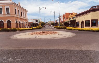 Stawell Historical Society Inc
Photograph - View Upper Main Street Looking East, Carol Ann Jones, Pizza Roundabout Cr. Main & Wimmera Streets 26th January 2020, 26/1/2020
... View Upper Main Street Looking East... & Wimmera Streets 26th January 2020 Photograph View Upper Main ...Roundabout removed on 28th January 2020 by councilRoundabout showing Post Office and Arcade -
Canterbury History Group
Photograph - Street view of the position of the bronze footpath plaque at the Canterbury Road and Maling Road junction, Jan Pigot, 2004
... Street view of the position of the bronze footpath plaque.... Photograph Street view of the position of the bronze footpath plaque ...Coloured photograph of thes treet view of the position of the bronze footpath plaque at the Canterbury Road and Maling Road junction.canterbury, maling road, shops, signs, plaques -
Canterbury History Group
Photograph - Street view of the peppercorn tree at the back of No. 92 Maling Road, Jan Pigot, 27/03/1993 12:00:00 AM
... Street view of the peppercorn tree at the back of No. 92...Canterbury Maling Road Shops Bryson Street Trees Peppercorn ...Coloured photograph of the peppercorn tree at the back of Buckley's Supermarket at shop No. 92 Maling Road.canterbury, maling road, shops, bryson street, trees, peppercorn trees -
Canterbury History Group
Photograph - Street view of the corner of Maling Road and Bryson Street, Jan Pigot, 27/03/1993 12:00:00 AM
... Street view of the corner of Maling Road and Bryson Street... the Bryson Street corner. Photograph Street view of the corner ...Coloured photograph of of the stage coach going down Maling Road taken from the Bryson Street corner.canterbury, maling road, shops, bryson street -
Canterbury History Group
Photograph - Street view of the Canterbury Mansions and the 2 shops next to it on Maling Road, Jan Pigot, 1994
... Street view of the Canterbury Mansions and the 2 shops next... the Mansions and the shops. Photograph Street view of the Canterbury ...Coloured photograph of the western side of the Canterbury Mansion depicting 2 shops on Maling Road with the garden space inbetween the Mansions and the shops.canterbury, maling road, shops, canterbury mansions -
Canterbury History Group
Photograph - Street view of shop No. 2 Bryson Street, Jan Pigot, 27/03/1993 12:00:00 AM
... Street view of shop No. 2 Bryson Street... at No. 2 Bryson Street Photograph Street view of shop No. 2 Bryson ...Coloured photograph of Sinclair's Real Estate shop at No. 2 Bryson Streetcanterbury, maling road, shops, bryson street, real estate offices -
Canterbury History Group
Photograph - Street view of shop No. 4 Bryson Street, Jan Pigot, 27/03/1993 12:00:00 AM
... Street view of shop No. 4 Bryson Street... Street view of shop No. 4 Bryson Street Jan Pigot ...Coloured photograph of the Commonwealth Bank at No. 4 Bryson Streetcanterbury, maling road, shops, bryson street, banks -
Canterbury History Group
Photograph - Street view of building at No. 216 Canterbury Road, Jan Pigot, 1994
... Street view of building at No. 216 Canterbury Road.... This was the orginal Salvation Army Hall Photograph Street view of building ...Coloured photograph of the building at No. 216 Canterbury. This was the orginal Salvation Army Hallcanterbury, maling road, shops, canterbury road, salvation army hall -
Canterbury History Group
Photograph - Street view of No. 86 maling Road, Jan Pigot, 27/03/1993 12:00:00 AM
... Street view of No. 86 maling Road... storey with the words The Block 1907. Photograph Street view ...Coloured photograph of the outside of No. 86 Maling Road including the top storey with the words The Block 1907.the block maling road, canterbury, maling road, shops -
Canterbury History Group
Photograph - Outside street view of No.88 Maling Road, Jan Pigot, 27/03/1993 12:00:00 AM
... Outside street view of No.88 Maling Road... Maling Road. Photograph Outside street view of No.88 Maling Road ...Coloured photograph for the front windows and door of the Maling Road Patisserie at No. 88 Maling Road.canterbury, maling road, shops -
Canterbury History Group
Photograph - Street view of the shop at No. 110 Maling Road, Jan Pigot, 1994
... Street view of the shop at No. 110 Maling Road... of the building Photograph Street view of the shop at No. 110 Maling Road ...Coloured photograph of the shop at No. 110 Maling depicting the 1st floor storey of the buildingcanterbury, maling road, shops -
Canterbury History Group
Photograph - Street view of shop No. 112 Maling Road, Jan Pigot, 1994
... Street view of shop No. 112 Maling Road.... Photograph Street view of shop No. 112 Maling Road Jan Pigot ...Coloured photograph of the shop at No. 112 Maling depicting the residence on the 1st Floor.canterbury, maling road, shops -
Canterbury History Group
Photograph - Street view of shop No. 108 Maling Road, Jan Pigot, 1994
... Street view of shop No. 108 Maling Road... Road Photograph Street view of shop No. 108 Maling Road Jan ...Coloured photograph of the fruit shop called Canterbury Fruit Emporium at No. 108 Maling Roadcanterbury, maling road, shops -
Canterbury History Group
Photograph - Street view of shop No. 116 Maling Road, Jan Pigot, 1994
... Street view of shop No. 116 Maling Road... of Milton's Jewellery shop at No. 116 Maling Road Photograph Street ...Coloured photograph of Milton's Jewellery shop at No. 116 Maling Roadcanterbury, maling road, shops, signs -
Canterbury History Group
Photograph - Street view of shop No. 96 Maling Road, Jan Pigot, 1994
... Street view of shop No. 96 Maling Road... of the hairdresser called So Chic at No. 96 Maling Road Photograph Street ...Coloured photograph of the hairdresser called So Chic at No. 96 Maling Roadcanterbury, maling road, shops -
Canterbury History Group
Photograph - Street view of shop No. 102 Maling Road, Jan Pigot, 1994
... Street view of shop No. 102 Maling Road... of Canterbury Lace shop No. 102 Maling Road Photograph Street view ...Coloured photograph of Canterbury Lace shop No. 102 Maling Roadcanterbury, maling road, shops -
Canterbury History Group
Photograph - Street view of shop No. 106 Maling Road, Jan Pigot, 1994
... Street view of shop No. 106 Maling Road... of the shop at No. 106 Maling Road Photograph Street view of shop ...Coloured photograph of the shop at No. 106 Maling Roadcanterbury, maling road, shops