Showing 1122 items
matching waterway
-
 Lakes Entrance Historical Society
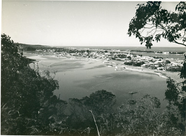
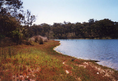
Photograph - Township, 1910c
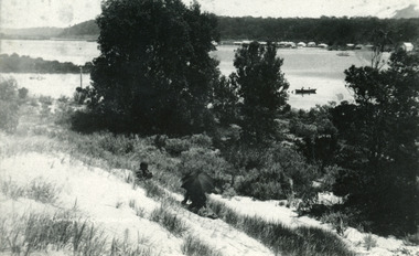
One other copyBlack and white photograph of the township, taken from the hummocks. It shows a person sitting under a black umbrella on a sand hill in the foreground, Cunninghame Arm, two persons in rowboat on water, buildings along Esplanade, Kalimna Heights in background. Lakes Entrance Victoriatopography, waterways -
 Lakes Entrance Historical Society
Photograph - Kalimna, Fraser Nancy, 1980c
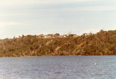
Colour photograph of private residences on the Kalimna escarpment. It shows houses above a timbered cliff at the northern shore of the North Arm of the lake, bare areas on cliff side indicating recent land slide. Lakes Entrance VictoriaHouses Seaview Parade Kalimna North Arm Lakes Entrance (on back) topography, waterways -
 Lakes Entrance Historical Society
Photograph - The Entrance, 1910c
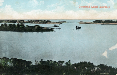
Colour tinted photograph of the entrance from Bass Strait to the Gippsland Lakes. It shows the small village on the hummocks, Bullock Island with bathing boxes at western end, machinery building groyne's from Bullock Island. Boat in the water. Lakes Entrance VictoriaGippsland Lakes Entranceislands, ships and shipping, topography, waterways -
 Lakes Entrance Historical Society
Postcard - Lake Tyers
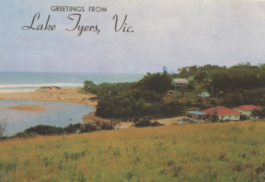
Colour Photograph of Lake Tyers Beach and Kiosk, many people on the beach Greetings from Lake Tyers Vicboats and boating, forest, waterways, jetties, beaches -
 Lakes Entrance Historical Society
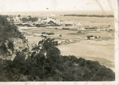
Photograph - Township, 1955
Also black and white postcard, similar view, titled Lakes Entrance through the trees from Lovers Walk. Bulmer copyright.Black and white photograph of a view from Kalimna Heights overlooking township. Shows North Arm, Marine Parade, Cunninghame Arm and sand hummocks with Bass Strait in distance. Lakes Entrance Victoriatownship, waterways -
 Lakes Entrance Historical Society
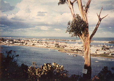
Photograph - Township, 1980
Also two different views of Lakes Entrance from KalimnaColour photograph showing the township situated on the land between the two stretches of water, the North Arm and the Cunninghame Arm. In the background can be seen the sand hummocks and the Southern Ocean. Lakes Entrance Victoria township, waterways -
 Lakes Entrance Historical Society
Postcard - Township, 1930c
Black and white small format postcard showing the township situated on the land between the Cunninghame Arm and North Arm. Lakes Entrance VictoriaLakes Entrance from Princes Highway (on back)bridges, township, topography, waterways -
 Lakes Entrance Historical Society
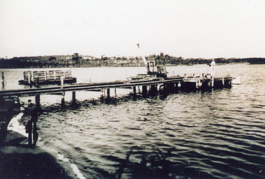
Photograph - Footbridge, Jemmeson Edie, 1936
One other copyBlack and white photograph of the first section of the footbridge being constructed across the Cunninghame Arm, it shows work underway. Pile driver at end of partly constructed bridge. Lakes Entrance Victoriabridges, waterways -
 Lakes Entrance Historical Society
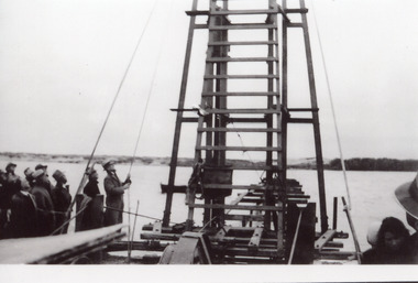
Photograph - Footbridge, Jemmeson Edie, 1936
One other copyBlack and white photograph of Albert Lind MP driving the first pile to commence construction of footbridge across Cunninghame arm, Lakes Entrance, Victoria.bridges, waterways -
 Lakes Entrance Historical Society
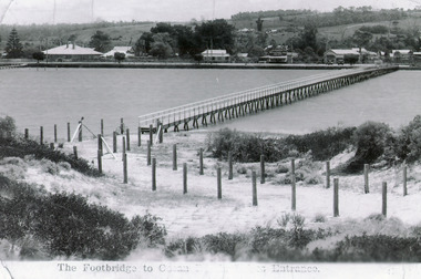
Photograph - Footbridge, 1937c
Two other copies 6.5 x 9 imageBlack and white photograph showing waterfront, Esplanade, some buildings and background hill almost completed footbridge across Cunninghame Arm. Posts defining pathway over sand dune to ocean beach. Lakes Entrance VictoriaFootbridge to Ocean Beach, Lakes Entrancewaterways, bridges, township -
 Lakes Entrance Historical Society
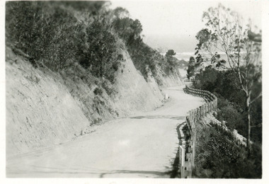
Postcard - Princes Highway Kalimna, 1920c
Black & white small format postcard of the Princes Highway at Kalimna. It shows the gravel road between the steep road cutting and post & rail fence. Bass Strait in distance. Lakes Entrance Victoriaroads and streets, fences, waterways -
 Lakes Entrance Historical Society
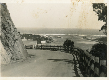
Postcard - The Entrance, Bulmer H.D, 1940c
Black and white small format postcard showing a bend in the Princes Highway on the Kalimna Hill. The road runs between the steep road cutting and post and rail guard fence. The artificial entrance from Bass Strait to Lakes system is in view. Lakes Entrance Victoriawaterways, islands -
 Lakes Entrance Historical Society
Book, Environment Studies Association of Victoria, Report to the Management Committee, Nyerimilang Estate, 1978
A report to the management committee of the Nyerimilang Estate on the assessment of the conservation and education potentials and development needs of Nyerimilang, Gippsland Lakes Victoria.parks, waterways, heritage -
 Lakes Entrance Historical Society
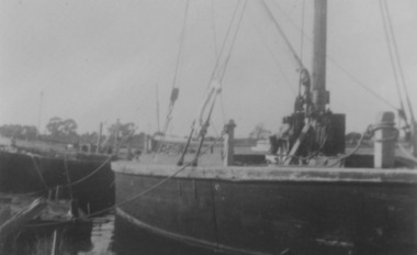
Photograph, 1938
Also two black and white copies 12.5 x 17.5 cm, second copy 10 x 15 cm.Black and white photograph showing remains of the S S JCD on extreme left, No. 9 engine powered stone barge centre and rebuilt Lady Harriet barge on right. Paynesville Victoria.ships and shipping, waterways -
 Lakes Entrance Historical Society
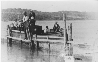
Photograph - Fish Pens, 1925 c
Black and white photograph of group of people on a boat at fish pens, one man standing on the fence of fish pen. Jemmys Point and Kalimna in background. Lakes Entrance VictoriaFish Pensfishing industry, waterways -
 Lakes Entrance Historical Society
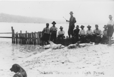
Photograph - Fish Pens, 1925
Black and white photograph showing fishermen at fish pens. Shows ten men on beach beside fence, 2 or 3 large sharks on beach, spaniel dog on beach. Lakes Entrance Victoriafishing industry, boats and boating, fish, waterways -
 Lakes Entrance Historical Society
Photograph, 2012
Date made December 2012Colour photograph of the railway bridge over Boggy Creek at Nowa Nowa. Bridge is built on combination of solid concrete piers, timber trestle piers on concrete to flood level, and timber piers. Nowa Nowa Victoriabridges, waterways, transport -
 Lakes Entrance Historical Society
Photograph - Lakes Tyers Landing, 1999 c
Site was important during tourism era of the 1880's to 1940's, when coachloads of passengers transferred to trips around Lake Tyers and up to Nowa Nowa. Also known as Bulmer's Landing.A colour photograph of the former tourist landing on Lake Tyers, showing remnant piles of a jetty, calm waters of lake and a high tree covered bank opposed the low jetty shore. Lake Tyers Beachtopography, waterways, landing -
 Lakes Entrance Historical Society
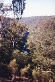
Photograph - Boggy Creek Gorge, 1999
Boggy Creek Gorge cuts through volcanics just before it meets salty water at Nowa Nowa Arm of Lake Tyers.Colour photograph from a vantage point of the distant Boggy Creek Gorge surrounded by steep tree and scrub covered ranges. Nowa Nowa Victoriavegetation, waterways -
 Lakes Entrance Historical Society
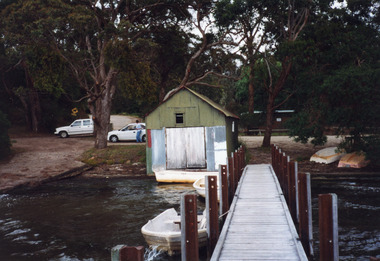
Photograph - Nungurner Jetty, 1999
Constructed 1940 by Kleinitz family using local and recycled materials.Colour photograph of a rustic building situated on the bank of the lake beside the Nungurner Jetty, Gippsland Lakes. Entirely clad in corrugated iron, black painted walls and red painted gable roof, double door facing lake. Nungurner Victoriawaterways, jetties, buildings -
 Lakes Entrance Historical Society
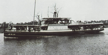
Photograph - JCD, 1920
Also one other photograph enlargement 16 x 21.5Black and white photograph showing the SS JCD on the Mitchell River with crowd of excursionists onboard, buildings on bank in background, three people sitting on lifeboat on top deck. Bairnsdale Victoriaships and shipping, waterways -
 Lakes Entrance Historical Society
Photograph - Nyerimilang Jetty, Buckland, 1942 c
Black and white photograph of jetty below the homestead of Nyerimilang. Crane positioned at end of jetty, a fenced barge used for transporting sheep is at anchor behind the jetty. Gippsland Lakes Victoriajetties, waterways, tourism -
 Lakes Entrance Historical Society
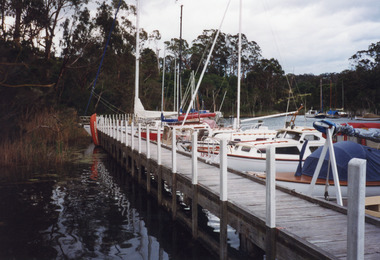
Photograph - Chinaman's Creek, 1999
Site occupied by Chinese fishermen and gardeners late 1800's and early 1900's.Colour photograph of the jetty at Chinaman's Creek showing yachts and launches moored on lake side of jetty, moored yachts visible in distance under timbered bank. Metung Victoriawaterways, jetties, boats and boating -
 Lakes Entrance Historical Society
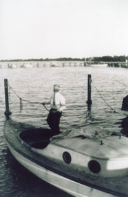
Photograph, Buckland, 1942 c
Man in boat believed to be William BucklandBlack and white photograph of man standing in cockpit of small half cabin sailing type boat tied to mooring poles, jetty with other boats in background. Gippsland Lakes Victoriawaterways, boats and boating -
 Lakes Entrance Historical Society
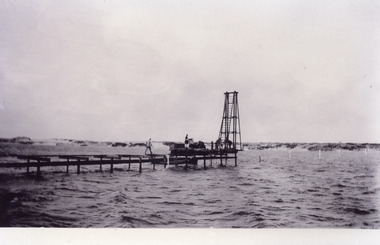
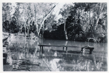
Photograph - Mississippi Creek Landing, 1950
From 1910c to 1940c stone was bought from quarry by tramline to the entrance and other sites around the lakes for stabilisation works.Black and white photograph of a derelict landing at Mississippi Creek, North Arm, showing remains of piles without decking on bank, unattached jetty in water. Creek surrounded by trees. East Gippsland Victoriatransport, waterways -
Lakes Entrance Historical Society
Book, Bird E C F, The Geomorphology of the Gippsland Lakes Region, 1978
A geomorphological study of the Gippsland lakes Region Victoria with reference to the effects of the artificial entrance, settlement, erosion and salinity on the changes to the configuration of the lakes, rivers, and coastline.natural history, waterways, genealogy -
Lakes Entrance Historical Society
Book, Pitt M W and Synan T P, The Past Present and Future of the Gippsland Lakes, 1987
Edited account of the papers presented at the Save the Gippsland Lakes Committees symposium on Lake Wellington and Lake Coleman held in Sale, November 1986. Includes history, geology, flora and fauna, and the many aspects of human impact on the region. Ilwaterways, government -
Lakes Entrance Historical Society
Book, Land Conservation Council Victoria, Final Recommendations Gippsland Lakes hinterland Area, 1983
1980 report and recommendations of the Victorian Land Conservation Council, for the balanced use of public land in teh gippsland Lakes Hinterland includes reserves schools forests rivers foreshores and other public sites. Map and diagrams added.topography, parks, waterways -
Lakes Entrance Historical Society
Book, Bird E C F, The Silt Jetties at the Mitchell River, 1972
The first of a series of scientific and historical studies of Gippsland to be published by the Bairnsdale Advertiser. The formation of the Mitchell River Silt Jetties is explained, and schemes for protecting this unique and fragile area of Victoria are suRuth Clarkgenealogy, waterways, topography -
 National Vietnam Veterans Museum (NVVM)
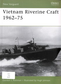
Book, Rottman, Gordon L, Vietnam Riverine Craft 1962-75, 2006
In 1965 the military situation in the Mekong River Delta of southern Vietnam had deteriorated to such a degree that the decision was made to commit a joint US Army and Navy Mobile Riverine Force to the area.In 1965 the military situation in the Mekong River Delta of southern Vietnam had deteriorated to such a degree that the decision was made to commit a joint US Army and Navy Mobile Riverine Force to the area.vietnam war, 1961-1975 -- riverine operations, american, inland waterway vessels, mekong river delta, navy mobile riverine force, us army