Showing 4370 items
matching west street
-
 Glenelg Shire Council Cultural Collection
Postcard - Postcard - Bentinck Street Portland, Victoria, n.d
... Black and white photo postcard - Bentinck Street Portland... postcard - Bentinck Street Portland, west side, between Julia ...Syd Cuffe was the Portland Town Crier from 1983 to 2013. The role of Town Crier was created for Syd Cuffe in 1983 in the lead up to Portland’s 150th anniversary celebrations held in 1984-85. 200 items from Mr. Cuffe’s estate were donated to the Glenelg Shire Cultural Collection. The items relate to his town crying activities and community work across the Shire and further afield.Black and white photo postcard - Bentinck Street Portland, west side, between Julia and Gawler Sts, Southern Cross Series 10800 -
Port Melbourne Historical & Preservation Society
Photograph - Graffiti below Graham Street overpass, Port Melbourne, Pat Grainger, 1991
... Street overpass, taken from Station Street looking West toward... overpass, taken from Station Street looking West toward the tram ...Original colour photograph of graffiti below the Graham Street overpass, taken from Station Street looking West toward the tram linebuilt environment - civic, arts and entertainment - visual arts, graham street -
 Rutherglen Historical Society
Image, c1930
... paper. This one is of Main Street, looking west from the corner..., mounted on orange paper. This one is of Main Street, looking west ...Building on left of street, in the foreground was originally the Bank of Victoria, and is now the NAB. Further along on that side is the Rutherglen Hotel, now Poachers Paradise. In the foreground on the right, is the Star Hotel.One of three black and white photographs, mounted on orange paper. This one is of Main Street, looking west from the corner of High Street. Written on mount: "Looking west from cnr High & Main St. Circa 1930's"main street, bank of victoria, nab, rutherglen hotel, poachers paradise hotel, star hotel, hotels, banks -
 Buninyong & District Historical Society
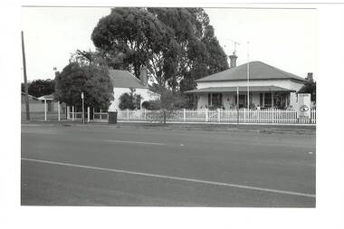
Photograph - B/W photograph, Mr. C. J. Brooks, Former Middleton's Hardware Shop Warrenheip Street Buninyong and residence, 19th April 1994
... Black and white photograph of streetscape, West side..., West side of Warrenheip Street North showing weatherboard ...1994 photograph of early well known Hardware shop and residence associated with the Middleton family.Example of an early weatherboard shop and residence operated by a local familyBlack and white photograph of streetscape, West side of Warrenheip Street North showing weatherboard residence and hardware shop associated with the Middleton familymiddleton family, warrenheip street, hardware shop, building, streetscape, ironmongery, weatherboard, local business -
 Lakes Entrance Historical Society
Photograph - Lakes Entrance, 1952c
... Colour photograph of town from Myers Street looking west... Myers Street looking west showing footbridge, Cunninghamme Arm ...Colour photograph of town from Myers Street looking west showing footbridge, Cunninghamme Arm and North Arm Lakes Entrance Victoriaaerial photograph, township -
 Bendigo Historical Society Inc.
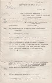
Document - H. A. & S. R. WILKINSON COLLECTION: CONTRACT OF SALE
... West by a depth of 392 links to Mistletoe Street being Crown... of 125 links to McKenzie street West by a depth of 392 links ...Contract of sale of land dated 28th April, 1956 between Mr. L. F. Bright (vendor) and Mrs. E. Tyack (purchaser). Property: land having a frontage of 125 links to McKenzie street West by a depth of 392 links to Mistletoe Street being Crown allotment 10 section 578 Parish of Sandhurst City of Bendigo being land described in certificate of title volume 5975 folio 905 and situate corner McKenzie Street West and Mistletoe Street, Golden Square, together with weatherboard dwelling and all sundry outbuilding, also all inside and outside blinds, lino in backroom, all curtains, except those in the front bedroom and all electric light fittings and shades escept shade in lounge room. Price 1,100 pounds.organization, business, h.a. & s.r wilkinson real estate -
 Tatura Irrigation & Wartime Camps Museum
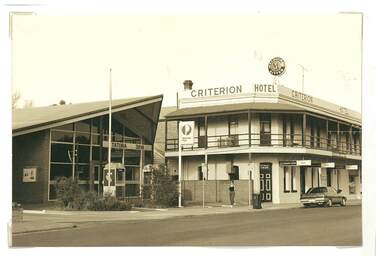
Photograph, Criterion Hotel, Tatura
... , Hogan Street, Tatura. Looking west along Hogan Street. ... and Criterion Hotel, Hogan Street, Tatura. Looking west along Hogan ...Shows picture of Tatura Post Office and Criterion Hotel, Hogan Street, Tatura. Looking west along Hogan Street. Sepia photograph showing Tatura Post office and Criterion Hotel. Photograph stuck onto piece of white cardboard. tatura victoria, hogan street tatura, tatura post office, criterion hotel tatura -
 City of Ballarat Libraries
Photograph, Western view along Sturt Street from Grenville Street 1899
... Looking west from Grenville Street along Sturt Street... Ballarat East goldfields Looking west from Grenville Street along ...Looking west from Grenville Street along Sturt Street. A Horse Drawn Tram can be seen along with the Rotunda.sturt street, grenville street, streetscape, commerical, gardens, trams, horses, ballarat -
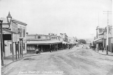
 Stawell Historical Society Inc
Postcard, Street scene looking West c1910 -- Postcard
... Street scene looking West c1910 -- Postcard...Street scene looking West c1910. Midway down street.... grampians Street scene looking West c1910. Midway down street ...Street scene looking West c1910. Midway down street.stawell businesses -
 Federation University Historical Collection
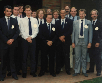
Photograph - Photograph - Colour, Group Portrait of Brewing Students with Premier John Cain, 1990, 1990
... of Pacific Maltings in Gregory Street West, Ballarat by Premier... Maltings in Gregory Street West, Ballarat by Premier of Victoria ...The photo was taken in 1990 at the official opening of Pacific Maltings in Gregory Street West, Ballarat by Premier of Victoria the Hon. John Cain. Group portraits of 14 men on a footpath next to a brick building. Most of the group are brewing students at Ballarat University College. I. Kerr (Brewing Student) R. Vickers (Brewing Student) G. Vincent (Brewing Student) S. Page (Brewing Student) G. Hughes (Brewing Student) S.T. Williams (Brewing Student) T. Gaffney (Brewing Student) Neville Gower (Lecturer in Brewing ) G. Fox (Brewing Student) Premier John Cain I. Richardson (Lecturer in Brewing) L. Cormie (Brewing Student) P. Vawdrey (Brewing Student) J. Armstrong (Brewing Student)i kerr, r. vickers, g. vincent, s. page, g. hughes, s.t. williamst. gaffney, neville gower, g. fox, premier john cain, i. richardson, l. cormie, p. vawdrey, j. armstrong, pacific maltings, s.t. williams, t. gaffney -
 Bendigo Historical Society Inc.
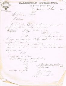
Document - COHN BROTHERS COLLECTION: HANDWRITTEN LETTER DATED 1893
... Bourke Street West, Melbourne dated 11th March 1893. sent... & Co Salisbury Buildings 66 Bourke Street West, Melbourne dated ...Printed letterhead L Zwicker & Co Salisbury Buildings 66 Bourke Street West, Melbourne dated 11th March 1893. sent to Cohns Bros re quote for purchase of goods, signed L Zwicker.bendigo, industry, cohn bros brewery -
 Ballarat Heritage Services
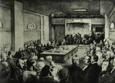
Photograph - Image, First Legislative Council of Victoria, 1851, 1851
... Hall, oOurke Street West, Melbourne. ... Hall, oOurke Street West, Melbourne. First Legislative Council ...Black and white image of the first Legislatie Council of Victoria on 03 November 1851. Leading citizens attended the inauguration by Governor La Trobe. The meeting was held at St Patrick's Hall, oOurke Street West, Melbourne. governor la trobe, parliament, legislative council of victoria -
 Bendigo Historical Society Inc.
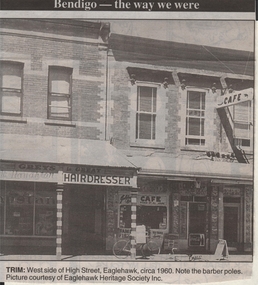
Newspaper - JENNY FOLEY COLLECTION: TRIM
... : west side of High Street, Eaglehawk, circa 1960. Note... ''The way we were'' from 1999. Trim: west side of High Street ...Bendigo Advertiser ''The way we were'' from 1999. Trim: west side of High Street, Eaglehawk, circa 1960. Note the barber poles.newspaper, bendigo advertiser, the way we were -
 Buninyong & District Historical Society
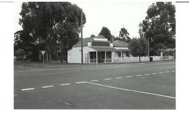
Photograph - B/W photograph, Mr. C. J. Brooks, Former Middleton's Hardware Shop Warrenheip Street Buninyong, 19 April 1994
... Middleton's Hardware Store on the West Side of Warrenheip Street North... Middleton's Hardware Store on the West Side of Warrenheip Street North ...1994 photograph of early well known Hardware shop (built 1906) operated by the Middleton family.Example of an early weatherboard shop and residence operated by a local familyBlack and white photograph of former weatherboard Middleton's Hardware Store on the West Side of Warrenheip Street North. Adjacent residential house clearly visible.middleton family, hardware shop, local business, weatherboard, building, streetscape, warrenheip street -
 Bendigo Historical Society Inc.
Document - MCCOLL, RANKIN AND STANISTREET COLLECTION: MAP OF MINE LEASES SYMONDS STREET, MCKENZIE ST WEST AREA BENDIGO, 2nd September, 1936
... LEASES SYMONDS STREET, MCKENZIE ST WEST AREA BENDIGO.... Streets include Holly Street, MacKenzie Street West, Symonds... Holly Street, MacKenzie Street West, Symonds Street, Aspinall ...Blue waxed linen paper map. On top' Mining District of Bendigo' Parish of Sandhurst, County of Bendigo' Map shows lease 10135, area 32.1.19; lease 10371, area 30.0.23; lease 10179 area 41.3.4; lease 10370, area 49.0.1. Map indicates gully leading into and State Rivers and Water supply reservoir, water race; siphon, shaft, dam, residential area and some residential lots marked. Streets include Holly Street, MacKenzie Street West, Symonds Street, Aspinall Street, Emmett Street; Bendigo Creek marked at bottom of map. Scale 4 chains to one inch. Map is not dated.bendigo, mining, mccoll rankin & stanistreet -
 Stawell Historical Society Inc
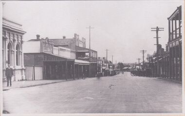
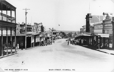
Photograph, Main Street Stawell looking West 1906
... Main Street Stawell looking West 1906...Main Street Looking West. Wooden Bull and Mouth Hotel 1906...Main Street Looking West. Wooden Bull and Mouth Hotel 1906 ...Main Street Looking West. Wooden Bull and Mouth Hotel 1906stawell -
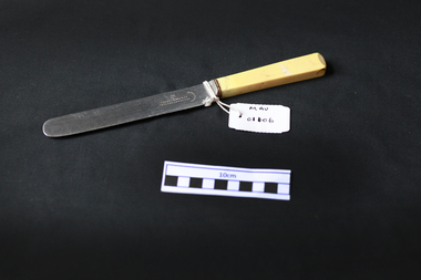 City of Moorabbin Historical Society (Operating the Box Cottage Museum)
Kitchen Equipment, cutlery, table knife, c1930
... Frank Cobb founded his business in West Street , Sheffield... founded his business in West Street , Sheffield in 1903. The firm ...Frank Cobb founded his business in West Street , Sheffield in 1903. The firm specialised in plated goods, but also registered marks for silver with Sheffield Assay Office in 1903, 1905 and 1907. The firm grew steadily and aquired Boardman, Glossop & Co in 1923. By 1927 the workforce numbered 250. The manufacture of stainless steel table knives helped the firm expand further in the 1930s, moving to Howard Works in Broad Street in 1933. Records at Sheffield Assay Office indicate that Frank Cobb registered the firm's mark 'FC' on the 15th November 1934. The Frank Cobb Group of companies continued in business well beyond the death of Cobb himself in 1957, eventually being liquidated in 1986. This Stainless steel knife with a bone handle is typical of the cutlery used by early settlers in Moorabbin shire c1930A stainless steel table knife with a bone handle used for the main course of a mealFRANK COBB & C0. / CUTLERS SHEFFIELD / FIRTH'S STAINLESScutlery, stainless steel, frank cobb & co sheffield, england, early settlers, market gardeners, moorabbin, cheltenham, bentleigh, -
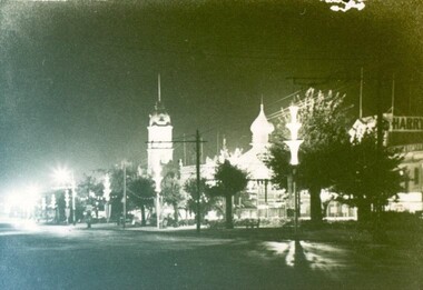 City of Ballarat Libraries
Photograph, Sturt Steet at night during Centenary Celebrations 1938
... A night scene looking west along Sturt Street during...City of Ballarat Libraries Eureka Centre Eureka Street ...A night scene looking west along Sturt Street during the Centenary Celebrations in 1938. The Town Hall Tower can be seen in the background.sturt street, centenary, town hall, ballarat -
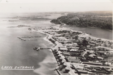 Lakes Entrance Historical Society
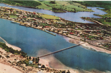
Photograph - Lakes Entrance, 1940c
... Black and white aerial photograph of town looking west from... looking west from Mechanics Street to Bullock Island with Kalimna ...Also black and white postcard of same view number 03853.1 size 8.5 x 14 cm . c1940Black and white aerial photograph of town looking west from Mechanics Street to Bullock Island with Kalimna escarpment and Rigby Fraser and Flanagan Islands in distance, Avenue of Honour Cypress trees on foreshore Lakes Entrance Victoriaaerial photograph, settlement, caravan parks, camping, ocean -
 Bendigo Historical Society Inc.
Photograph - ROY J MITCHELL COLLECTION: VIEW FROM LOOKOUT TOWER, QUEEN ELIZABETH OVAL, BENDIGO
... Oval, Bendigo, looking south west. View Street centre field..., looking south west. View Street centre field, QEO carpark and Art ...Colour photograph taken from lookout tower, Queen Elizabeth Oval, Bendigo, looking south west. View Street centre field, QEO carpark and Art Gallery buildings in foreground. Written on back of photo ' Jan 1972, Bendigo from Lookout Tower, Pall Mall (not accurate, should be View Street) towards Golden Square, by Roy J Mitchell'Roy J Mitchellbendigo, streetscape, queen elizabeth oval -
Glenelg Shire Council Cultural Collection
Postcard - Postcard - Julia Street, Portland, Victoria, n.d
... Postcard, hand-coloured. View of Julia Street, from west..., hand-coloured. View of Julia Street, from west of Julia/Percy ...Postcard, hand-coloured. View of Julia Street, from west of Julia/Percy St. intersection, looking east toward the sea. Postcard printed in GermanyFront: 'Julia Street, Portland' - white script on black, lower edge of postcard -
 Tatura Irrigation & Wartime Camps Museum
Photograph, Hogan Street, Tatura
... , Tatura, near Tatura Milk. Looking west along Hogan Street. ... Hogan Street, Tatura, near Tatura Milk. Looking west along Hogan ...Shows picture of a man walking his dog down Hogan Street, Tatura, near Tatura Milk. Looking west along Hogan Street. Sepia photograph showing man walking a dog near Tatura Milk, Hogan Street, Tatura. Photograph stuck onto piece of white cardboard. tatura victoria, hogan street tatura -
 Greensborough Historical Society
Document - Leaflet, Berry Street Victoria North East Region, North East Foster Care for children & adolescents, 2000c
... Publicity brochure for North East Foster Care, Nell Street... Foster Care, Nell Street Watsonia West foster care north east ...Publicity brochure for North East Foster Care, Nell Street Watsonia WestTri-fold leaflet, printed in colour both sidesnon-fictionfoster care, north east foster care, watsonia, berry street victoria -
Ballarat Heritage Services
Photograph - Black and White, Davies the Baker, Eureka Street, Ballarat
... The site of Davies the Baker became a playground west... a playground west of the Eureka Street Primary School. Davies Bakery ...The site of Davies the Baker became a playground west of the Eureka Street Primary School.A wide panoramic photograph showing numerous Davies Bread Bakery trukjs and drivers, and two members of the Davies family. They are standing together and are Frederick Tablot Davies, Mr Davies Senior, and Foreman Hector Godfrey's Smith.davies bakery, eureka street, frederick davies, hector godfrey smith -
 Whitehorse Historical Society Inc.
Photograph, Mitcham Angling Club Headquarters, 13/06/1986 12:00:00 AM
... , West side Brittania Street, Mitcham. Originally located... Coloured photos of Mitcham Angling Club Headquarters, West side ...Plans for this building were drawn by Ray Meagher, c1943.2 Coloured photos of Mitcham Angling Club Headquarters, West side Brittania Street, Mitcham. Originally located on Northern side of Guide Hall in small galvanised iron shed -(see NP1064) - now relocated in Brunswick Roadmitcham angling club, angler's club, meagher, ray -
 City of Ballarat Libraries
Photograph - Card Box Photographs, View along Sturt Street to the Arch of Victory, circa 1950
... View west from Gillies Street along Sturt Street to Arch... Ballarat East goldfields View west from Gillies Street along Sturt ...View west from Gillies Street along Sturt Street to Arch of Victory. Sheep can be seen grazing in the future Ballarat High School grounds.sturt street, arch of victory, streetscape, public, vehicle -
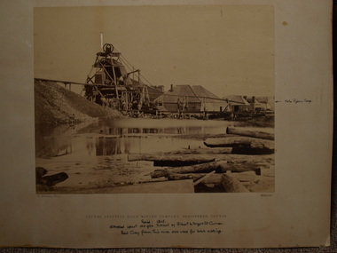 Clunes Museum
Photograph, C. NETTLETON, APPROX. 1865
... THIS MINE WAS SITUATED ABOUT 100 YARDS SOUTH WEST OF ALBERT...THIS MINE WAS SITUATED ABOUT 100 YARDS SOUTH WEST OF ALBERT ...THIS MINE WAS SITUATED ABOUT 100 YARDS SOUTH WEST OF ALBERT STREET AND ANGUS STREET CORNER. RED CLAY FROM THIS MINE WAS USED FOR BRICK MAKING..1 SEPIA PHOTOGRAPH OF CLUNES ALLUVIAL GOLD MINING CO. .2 SEPIA PHOTOGRAPH OF POPPET HEAD-MINERS ON PLATFORM-THATCHED ROOF BUILDINGS, SCATTERING OF LARGE LOGS IN FOREGROUND, USED FOR FIRES. .3 COPY OF ABOVE PHOTOGRAPH IN BLACK AND WHITE (POSTCARD SIZE).1 PRINTED: CLUNES ALLUVIAL GOLD MINING COMPANY REGISTERED CLUNES .2 PRINTED ON FRONT : ALLUVIAL GOLD MINING COMPANY REGISTERED CLUNES HANDWRITTEN: PERIOD 1865. SITUATED ABOUT 100 YDS SW OF ALBERT AND ANGUS STREET CORNER. RED CLAY FROM THIS MINE WAS USED FOR BRICK MAKINGphotographs, mining, clunes alluvial mining company -
![Map, Plan of Town Allotments Bacchus Marsh [1891-1897]](/media/collectors/5e461d8021ea67224c82f2a1/items/66acc1c90c778f9f64a3daec/item-media/66acc3990c778f9f64a3e09b/item-fit-380x285.jpg) Bacchus Marsh & District Historical Society
Bacchus Marsh & District Historical SocietyMap, Plan of Town Allotments Bacchus Marsh [1891-1897]
... Street - South border - Main Street - West border Gell Street... Street - South border - Main Street - West border Gell Street ...This plan of town allotments in Lerderderg Street and Bennett Street also includes the location of many of the buildings, shops, businesses and houses which were present in the retail and business area of Bacchus Marsh in the 1890s. The precise date of the plan is not known but it must be sometime between 1891 and 1897. The Post Office and the Wesleyan Church are both shown on this plan. Both of these were constructed in 1890. The plan does not show the Baptist Church in Main Street which was constructed in 1898. Hence the date is sometime between 1891 and 1897.This plan of Bacchus Marsh is one of the most detailed visual representations of the location of shops, businesses and houses in the central part of Bacchus Marsh. It provides very precise locations of most of the shops and houses in the town in the 1890s. A single page paper plan showing allotments of land fronting Lerderderg and Bennett Street. Buildings, businesses and houses along most of the streets are identified by hand written annotations. Streets identified on plan: Lerderderg Street - Bennett Street - Main Street - Gell Street - Young Street - Graham Street. Physical boundaries of the map are: North border - Lerderderg Street - South border - Main Street - West border Gell Street - East border - Young Street. The plan is pasted into a bound volume containing 76 maps or plans in total. bacchus marsh victoria maps, shops bacchus marsh -
Port Melbourne Historical & Preservation Society
Photograph - Bay Street, Sandridge, 1891
... from Graham Street to Beach Street and Railway Pier, west side... to Beach Street and Railway Pier, west side of Bay Street ...Large black & white photograph from 1891 showing Bay Street from Graham Street to Beach Street and Railway Pier, west side of Bay Streetengineering, piers and wharves - station pier, piers and wharves - railway pier, bay street, graham street, beach street -
Tatura Irrigation & Wartime Camps Museum
Photograph, Heaphy's Whim-Inn Hotel
... Heaphy's Whim-Inn Hotel; South West corner of Hogan Street...Tatura Irrigation & Wartime Camps Museum 49 Hogan Street ...Heaphy's Whim-Inn Hotel; South West corner of Hogan Street and Dhurringile Road. Features a variety of patrons outside hotel; two horse-drawn buggies.tatura, buildings, historic, transport, horse, costume, male