Showing 338 items matching "work environment"
-
 Port Melbourne Historical & Preservation Society
Photograph - Prince Alfred Hotel, corner Spring and Bay Streets, Port Melbourne, 1988
These were found by former Port Melbourne social worker Beris CAMPBELL when clearing out old files. They were photographed by an unknown social work student in 1988 for a project "The Role of the Pub in the Social Fabric of Port Melbourne."One of a group of 20 photos of Port Melbourne hotels, taken by a student in 1988 for the project "The Role of the Pub in the Social Fabric of Port Melbourne". Prince Alfred (Large meals from $1.20)built environment - commercial, beris campbell, prince alfred hotel, business and traders - hotels -
Port Melbourne Historical & Preservation Society
Photograph - London Family Hotel, corner Beach and Princes Streets, Port Melbourne, 1988
These were found by former Port Melbourne social worker Beris CAMPBELL when clearing out old files. They were photographed by an unknown social work student in 1988 for a project "The Role of the Pub in the Social Fabric of Port Melbourne."One of a group of 20 photos of Port Melbourne hotels, taken by a student in 1988 for the project "The Role of the Pub in the Social Fabric of Port Melbourne". London Family Hotelbuilt environment - commercial, beris campbell, london family hotel, business and traders - hotels -
Port Melbourne Historical & Preservation Society
Photograph - Exchange Hotel, corner Rouse and Bay Streets, Port Melbourne, 1988
These were found by former Port Melbourne social worker Beris CAMPBELL when clearing out old files. They were photographed by an unknown social work student in 1988 for a project "The Role of the Pub in the Social Fabric of Port Melbourne."One of a group of 20 photos of Port Melbourne hotels, taken by a student in 1988 for the project "The Role of the Pub in the Social Fabric of Port Melbourne". Exchangebuilt environment - commercial, beris campbell, exchange hotel, business and traders - hotels -
Port Melbourne Historical & Preservation Society
Photograph - Fountain Inn, Bay Street, Port Melbourne, 1988
These were found by former Port Melbourne social worker Beris CAMPBELL when clearing out old files. They were photographed by an unknown social work student in 1988 for a project "The Role of the Pub in the Social Fabric of Port Melbourne."One of a group of 20 photos of Port Melbourne hotels, taken by a student in 1988 for the project "The Role of the Pub in the Social Fabric of Port Melbourne". Fountain Inn (no signage)built environment - commercial, beris campbell, fountain inn, business and traders - hotels -
Port Melbourne Historical & Preservation Society
Photograph - Railway Club Hotel, Raglan Street, Port Melbourne, 1988
These were found by former Port Melbourne social worker Beris CAMPBELL when clearing out old files. They were photographed by an unknown social work student in 1988 for a project "The Role of the Pub in the Social Fabric of Port Melbourne."One of a group of 20 photos of Port Melbourne hotels, taken by a student in 1988 for the project "The Role of the Pub in the Social Fabric of Port Melbourne". Railway Clubbuilt environment - commercial, beris campbell, railway club hotel, business and traders - hotels -
 Port Melbourne Historical & Preservation Society
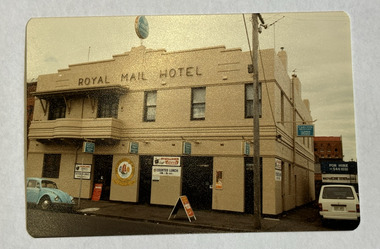
Photograph - Royal Mail Hotel, Bay Street, Port Melbourne, 1988
These were found by former Port Melbourne social worker Beris CAMPBELL when clearing out old files. They were photographed by an unknown social work student in 1988 for a project "The Role of the Pub in the Social Fabric of Port Melbourne."One of a group of 20 photos of Port Melbourne hotels, taken by a student in 1988 for the project "The Role of the Pub in the Social Fabric of Port Melbourne". Royal Mailbuilt environment - commercial, beris campbell, royal mail hotel, business and traders - hotels -
Port Melbourne Historical & Preservation Society
Photograph - Southern Cross Hotel, corner Ingles and Station Streets, Port Melbourne, 1988
These were found by former Port Melbourne social worker Beris CAMPBELL when clearing out old files. They were photographed by an unknown social work student in 1988 for a project "The Role of the Pub in the Social Fabric of Port Melbourne."One of a group of 20 photos of Port Melbourne hotels, taken by a student in 1988 for the project "The Role of the Pub in the Social Fabric of Port Melbourne". Southern Cross Hotelbuilt environment - commercial, beris campbell, southern cross hotel, business and traders - hotels -
Port Melbourne Historical & Preservation Society
Photograph - Rising Sun Hotel, corner Bay and Boundary Streets, Port Melbourne, 1988
These were found by former Port Melbourne social worker Beris CAMPBELL when clearing out old files. They were photographed by an unknown social work student in 1988 for a project "The Role of the Pub in the Social Fabric of Port Melbourne."One of a group of 20 photos of Port Melbourne hotels, taken by a student in 1988 for the project "The Role of the Pub in the Social Fabric of Port Melbourne". Rising Sun "1927"built environment - commercial, beris campbell, rising sun hotel, business and traders - hotels -
Port Melbourne Historical & Preservation Society
Photograph - Sandridge Hotel, corner Beach and Stokes Streets, Port Melbourne, 1988
These were found by former Port Melbourne social worker Beris Campbell when clearing out old files. They were photographed by an unknown social work student in 1988 for a project "The Role of the Pub in the Social Fabric of Port Melbourne."One of a group of 20 photos of Port Melbourne hotels, taken by a student in 1988 for the project "The Role of the Pub in the Social Fabric of Port Melbourne". Sandridge Hotelbuilt environment - commercial, beris campbell, sandridge inn, business and traders - hotels -
Port Melbourne Historical & Preservation Society
Photograph - Victoria Hotel, corner Graham and Bay Streets, Port Melbourne, 1988
These were found by former Port Melbourne social worker Beris CAMPBELL when clearing out old files. They were photographed by an unknown social work student in 1988 for a project "The Role of the Pub in the Social Fabric of Port Melbourne."One of a group of 20 photos of Port Melbourne hotels, taken by a student in 1988 for the project "The Role of the Pub in the Social Fabric of Port Melbourne". Victoria Hotelbuilt environment - commercial, beris campbell, victoria hotel, business and traders - hotels -
Port Melbourne Historical & Preservation Society
Photograph - Rose & Crown Hotel, Bay Street, Port Melbourne, 1988
These were found by former Port Melbourne social worker Beris CAMPBELL when clearing out old files. They were photographed by an unknown social work student in 1988 for a project "The Role of the Pub in the Social Fabric of Port Melbourne."One of a group of 20 photos of Port Melbourne hotels, taken by a student in 1988 for the project "The Role of the Pub in the Social Fabric of Port Melbourne". Rose & Crownbuilt environment - commercial, beris campbell, rose & crown hotel, business and traders - hotels -
Port Melbourne Historical & Preservation Society
Document, City of Port Melbourne, Valuation of Licenced Premises in City of Port Melbourne, 1950 - 1974
Valuation of Licenced Premises in City of Port Melbourne. Work papers maintained by the City Valuer, Mr George LEVEY, concerning the valuation of Licenced premises in the City of Port Melbourne.local government - city of port melbourne, george levey, built environment - commercial, business and traders - hotels -
 Port Melbourne Historical & Preservation Society
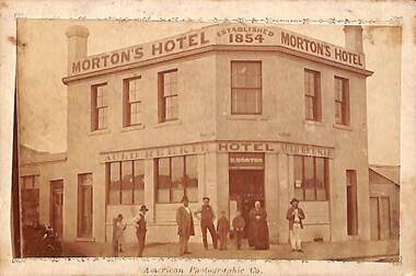
Photograph - Morton's Auld Reekie Hotel, C. 1880
John TURNBULL was a prominent citizen of Sandridge/Port Melbourne. He started as a baker in Bay St then moved to the corner of Rouse and Nott Streets where he ran his baking business until leasing the premises to various licensees as The Auld Reekie Hotel. The Sands & McDougall Directory of 1880 shows Turnbull owned a store in Rouse Street, next door to the hotel. He served on Council for 15 years with one term as Mayor, 1877-78. John TURNBULL died on 13 March 1889. This item was passed on to Nancy U'REN with a small number of items relating to the Turnbull family with an early 1970s note from Suzanne GORDON, great-granddaughter of Barbara Annie TURNBULL nee GOULD, wishing Nancy good luck with her work on Sandridge.Sepia photograph showing several people standing outside the Auld Reekie Hotel."B Turnbull", "Sandridge", "Pt Melb" and "60 years" hand-written in pencil on reverse.rouse street, built environment - commercial, auld reekie hotel, nott street, john turnbull, nancy u'ren nee morris, business and traders - hotels -
 Federation University Art Collection
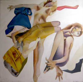
Painting - Acrylic on canvas, 'Glade of the Mystique Seductress' by Julie Watkins, 1971
This painting is one of my key early works incorporating the Baroque dualities of theatrical drama and inner emotional worlds. Interpreting the Baroque subject of the Sacred and the Profane, the swirling diagonal composition of crossed figures, transparent and billowing drapery in contrasting colours and dramatically tense gestures, in this work combine to suggest both religious ecstacy and physical sensuality. The glade is portrayed as white light. It is the open space for the drama. One face gazes ambiguously at the viewer, questioning, whether she is - the willing but (guarded OR mysterious?) seductress the title suggests. Julie Watkins, 2015 Julie WATKINS (1949- ) In 1969 Julie Watkins completed an Associateship Diploma Fine Art-Painting at RMIT, and a Fellowship Diploma of Fine Art-Painting the year after. In 1973 she was awarded a Diploma of Education at Hawthorn State College. Julie Watkins worked as a TAFE teacher from1973 to 1978, then as a tutor for the Faculty of Architecture and the Built Environment at RMIT between 1979 and 1992. Between the years 2003 to 2003 she was a tutor at the University of Melbourne (Victorian College of the Arts. This item is part of the Federation University Art Collection. The Art Collection features over 2000 works and was listed as a 'Ballarat Treasure' in 2007.Acrylic on stretched canvas art, artwork, julie watkins, watkins, painting, acrylic on canvas, available, julie meyer -
 Port Melbourne Historical & Preservation Society
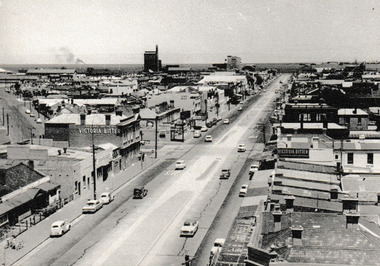
Photograph - Bay Street looking to the Bay 1963, c.1963
In 1963 work was being undertaken to create the central Plantation Strip that divides Bay Street. The layout of the strip can be seen although actual work has not begun. The photo possibly taken from Port Melbourne Town Hall tower. Note absence of traffic lights.Photograph looking toward the Bay before the installation of the central Plantation strip. On reverse 'Bay Street before plantation strip was started 1963'built environment - commercial, bay street, port melbourne town hall -
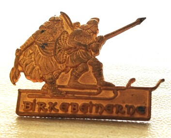 Falls Creek Historical Society
Decorative object - Birkebeiner Lodge Pin
This lapel pin originates from the Birkebeiner Lodge in Norway. The cross country ski race which originated there in 1932 was the inspiration for the annual Kangaroo Hoppet Race held in Falls Creek, Victoria. The Kangaroo Hoppet is Australia's premier long distance cross country ski race, and a member of the prestigious Worldloppet series of international cross country ski events. The first race at Falls Creek was held in 1979 under the name of “Australian Birkebeiner”. The course started and finished at the alpine ski village of Falls Creek, and took participants out into the wilderness area of the Bogong High Plains. Later, 42km became the main distance and after a few name changes, the name of Kangaroo Hoppet was adopted in 1990. The lapel pin was owned and donated by Diana Patterson who was a talented cross country skier. She was born in Tasmania and originally pursued a career as a physical education teacher. After making a major career change, she applied to join the Australian Antarctic Division. She applied four times before she was accepted. Diana first travelled to the Antarctic in October 1987. By this time only ten Australian women had spent a winter there. She first worked at Casey Station, before becoming leader at Mawson Station therein becoming the first female leader of an Antarctic base of any nation. After retiring Diana guided tourist expeditions to the Antarctic for many years, as well as continuing work in research and conservation. In 2012 she published her story “The Ice Beneath My Feet: My Year In Antarctica”. Diana Patterson was awarded the Medal of the Order of Australia (OAM) for "service to conservation and the environment”. As well as these outstanding career achievements, Diana has been a Board Member of both the Mt. Buller Alpine Resort Management Board, including a period as Chairman, and also the Falls Creek Resort Management Board. She was also a founding member of Falls Creek Historical Society.This medal belonged to a highly recognised Australian and founding member of the Falls Creek Historical Society.A small gold lapel pin from the Birkebeiner Lodge in the form of a Nordic skier with the name beneath it.diana patterson, falls creek, cross country skiing, kangaroo hoppet -
 Federation University Art Collection
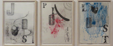
Work on paper, Patrice Mahoney, 'Jobs, Policy and LOST' (tryptich) by Patrice Mahoney, 2014
These works are a display of my frustration of hour our family were lucky we were not beheaded, scalped, taken away and impaled as a warning to others not to enter farming lands, which had been traditional lands of the Nganyaywana country. The word 'Policy' represents the White Australia Policy, the word "Lost' stands for those lost including hundreds of family members, 'Jobs' asks why Aboriginal people can only find employment if through Aboriginal positions and policies. The number 3 symbolises myself and my siblings, red is for bloodshed, blue is for secrets and black the family history. Patrice MUTHAYMILES MAHONEY OAM Anewan/Nganyaywan/Dunghutti country. Patrice Mahoney is a printmaker, sculptor, weaver, drawer and painter. Her work challenges mainstream and Aboriginal Australians and is profoundly influenced by space, place and country, taking inspiration from nature, environment and looking forward to a time when she can return to her family's traditional country to make work. In 2012 the artist completed a Bachelor of Visual and Media Arts at Monash University’s Churchill campus (from 2014 Federation University's Churchill Campus). The Victorian Indigenous Art Awards 2014 were exhibited and judged at the Art Gallery of Ballarat.This unique edition triptych involves the techniques of intaglio copper plate, pigment, soft ground, open bite, aquatint, spit-bite, stamping, relief, drawing and burnishing on paper. It was awarded the 2014 Victorian Indigenous Art Awards Federation University Acquisitive Award for for work by a Victorian regional artist. Text, colour, metaphor and Aboriginal symbolism are important components of her work. This work expresses the artist's frustration with unjust situations experienced by traditional owners of Nganyaywana country. The word 'Policy' refers to White Australia Policy, 'Lost' the hundreds of lost family members, and 'Jobs' highlights the difficulty of Aboriginal peple obtaining work, especially outside Aboriginal positions and policy. The number 3 symbolises Patrice Mahoney's siblings, with black used to denote family history. The violently splattered red represents bloodshed, with the blue washing across the work obscuring details and representing secrets. The Selection Panel of the 2014 Victorian Indigenous Art Awards made the following comments on the work: 'The selection panel for the Federation University Acquisitive Award for 2014 were highly impressed by this work and applauded the vigorous use of symbolism and metaphor in a well scripted visual composition. The poignancy of connectedness to the past, memory, place and country is palpable and enhanced by the suggestive employment of text and minimal colour. A provocative and evocative work of art!artist, artwork, patrice mahoney, aboriginal, victorian indigenous awards, jobs, culture, printmaking, drawing, policies, lost, victorian indigenous art awards, available, alumni -
 Warrnambool and District Historical Society Inc.
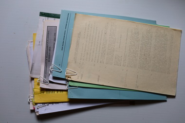
Administrative record (Collection) - Warrnambool City Council Administrative Records, Warrnambool City Council Officers, 1990s
Warrnambool City Council Records collected by a member of a Council Advisory Committee.Collection of Warrnambool City Council records of the 1990sIn folders and archival envelopes in an A3 archival boxTwo A3 archival envelopes containing information on Foreshore etc., five booklets containing reports on City Plans, Council Strategies etc and 15 Reports (Shop Trading, Coastal Wetlands, Foreshore, Landcare etc)warrnambool city council, warrnambool city council strategies and planswarrnambool city council, warrnambool city council strategies and plans -
 Eltham District Historical Society Inc
Document - Folder, Jim Connor et al, Eltham Gateway, 1987
The Eltham Gateway Group (EGG) was established about 1987 by some Eltham residents concerned for the development of the Eltham Gateway, defined as that historically and environmentally sensitive region of land along Main Road, Eltham extending from the roundabout at Fitzsimons Lane to Dudley Street, Eltham. The gateway was a unique urban area with a strong sense of character that provided a distinctive entrance to the Eltham Town Centre. The intention of this group was to support development that preserved both the natural and historic features of the gateway region. It encouraged development sympathetic to Eltham’s traditional association with the arts and natural environment. The group was initiated in response to a planning application in December 1986 to redevelop the then Mobil service station site at 729 Main Road, Eltham on the corner of Brougham Street. This group worked with and encouraged the Eltham Shire Council to consider rezoning to protect the gateway area. A detailed Eltham Gateway Study undertaken by Tract Consultants assisted with the establishment of the Eltham Gateway Zone, the Eltham Gateway Policy and the Eltham Gateway Design and Siting Guidelines. The State Government subsequently agreed to a planning amendment to rezone the land from a Residential Zone C to an Eltham Gateway Zone under the Eltham Planning Scheme. While zoning changes over the years have altered the mix of permitted uses within this area the Eltham Gateway still looks and feels like a predominately residential style precinct, even where non-residential type uses operate. EGG was followed by the establishment of the Eltham Protection Society in about 1989 to respond to community planning issues beyond the area of the Eltham Gateway and in effect took over the role from the EGG. Jim Connor President Eltham District Historical Society 4 July 2022 During 1986/87 I was a community member on the Shire of Eltham’s Community Consultative Committee involved with the Eltham Gateway Study, which led to the establishment of the original Eltham Gateway Zone, under the then Eltham Planning Scheme The Eltham Gateway Group was the pioneer community action group dedicated to protecting the character of the Eltham Gateway. It was succeeded by the Eltham Protection Society. When the Shire of Eltham Offices were demolished by the unelected Commissioners of Nillumbik Shire Council in July/August 1996, significant community upset and protest led to the establishement of the Eltham Gateway Action Group (EGAG) which in present day form has evolved into the Eltham Community Action Group (ECAG) focussing on issues throughout Eltham and not just the Eltham Gatewayeltham community action group, eltham gateway, eltham gateway action group, eltham gateway design and siting guidelines, eltham gateway group (egg), eltham gateway policy, eltham gateway study, eltham gateway zone, eltham planning scheme, eltham protection society, jim connor, michael wilson, rodger dalling, tony mcmanus -
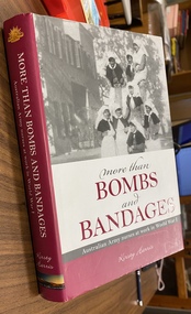 Returned Nurses RSL Sub-branch
Book, Kirsty Harris, More than Bombs and Bandages: Australian Army nurse sat work in World War I, 2011
... nursing and training, army, environments, patterns of work, impact ...Historical study of the work of Australian Army nurses during world War I. Covers nursing and training, army, environments, patterns of work, impact of disease, surgical nursing, legacy of AANSBlack cover, Maroon/and grey dust jacket, pp. xvi, 344.non-fictionHistorical study of the work of Australian Army nurses during world War I. Covers nursing and training, army, environments, patterns of work, impact of disease, surgical nursing, legacy of AANS -
 Eltham District Historical Society Inc
Photograph - Digital Photograph, Alan King, Queenstown Cemetery, Smiths Gully Road, St Andrews, 28 December 2007
The discovery of gold in Smyth's Creek in 1854 and subsequent gold rush to the Caledonia diggings led to the establishment of Queenstown (present day St Andrews). The first recorded burial was July 31st, 1861 and it was officially declared a Cemetery Reserve in 1866. Many graves are unmarked and unrecorded including many Chinese and other itinerant miners. The cemetery was closed for new burials in 1851. The last recorded burial was in 1981 in an existing family grave. In Loving memory of David Band Died 30th Decr. 1862, aged 51 years. John Cork Knell Died 11th April 1867, aged 42 years. Eliza Smith Died 20th Jany. 1874, aged 3 1/2 years. William Band Died 20th Feby. 1883, aged 51 years. Published: Nillumbik Now and Then / Marguerite Marshall 2008; photographs Alan King with Marguerite Marshall.; p73 The discovery of gold at Smyth’s Creek* in 1854 brought 3000 people to the area in search of their fortunes.1 However in the harsh conditions many miners and their families died young, and were buried in unmarked graves. Their stories died with them but by 1861, the first burial was recorded at the Queenstown Cemetery – that of William Dalrymple aged 65 – although the cemetery was only officially declared a reserve in 1866. Even before this in 1856, a double burial had been recorded for the twin baby daughters of George Harrison at Market Square, the miners’ settlement – presumably where the cemetery is today. In 1951 the Queenstown Cemetery at 70 Smiths Gully Road, Smiths Gully, closed for burials. However the last burial in a family plot, that of Grace Evelyn Smith, occurred in 1981. Today only 55 headstones remain, but more than 380 burials are recorded. Remnant bushland dominates the cemetery where many graves are merely mounds and others have been damaged by vandalism and the neglect of time. Bushfire in 1962 destroyed the picket fencing, grave markers and cypress boundary planted in the early 1900s. The box/stringybark woodland in the 1.7 hectare Cemetery Reserve is regrowth from then and the indigenous and heritage vegetation is protected. Thanks to the volunteer Cemetery Trust and Friends & Relations of Queenstown Cemetery, the cemetery is maintained, stories recorded and the burial index corrected and expanded.2 Close by the cemetery on the site of today’s Peter Franke Picnic and Nature Reserve stood Market Square, the Caledonia Diggings village of tents and stores, the forerunner of Queenstown, now St Andrews. Many of the Caledonia Diggings miners were Chinese, many of whom, with itinerant prospectors, were buried in unmarked graves. Histories are being recorded of other immigrants, mainly English and German, who settled after the gold rush, some of whose descendants fought and died in the two world wars. Names on many headstones are also recorded on the district’s roads, reserves and war memorials such as Motschall, Joyce, Howard and Coutie. The oldest surviving tombstone is that of Scot, David Band who died in 1862 at 51 years. His oldest daughter Elizabeth, with husband John Knell, owned the Queenstown Hotel and the post office. Child-rearing in a colonial gold town was often tragically difficult, as demonstrated in the first 20 years, when 41% of the 34 burials recorded were children. Settlers endured harsh conditions graphically illustrated with the deaths of Annie Joyce at 30 years and of her family. Annie was married to gold miner Walter Joyce. Their third child Walter, born in 1886, died in March 1887. Eight months later Annie died of breast cancer. Walter died in 1909, aged 53, of miner’s phthisic caused by stone dust destroying his lungs. It was so hard to make a living that burials were usually held from 2.30 pm to allow mourners to work a day before paying their last respects.3 Most burials before 1890 were recorded as Anglicans, as the only church on the Caledonia Diggings was the Church of St Andrew, until 1897, when the Primitive Methodist Church came to Panton Hill. Generally miners came to better themselves, but some, like Grace Hopkinson (nee Milward), born in England in 1828, came from a well-off and educated family. According to family legend Grace emigrated with husband William, to live in a tent, but had kept her personally embossed sterling silver cutlery service. Amid the tough environment were some successes like that reported in The Evelyn Observer April/May 1901 of miner William Hopkinson who was buried at the cemetery in 1912 aged 81. The Observer stated that Hopkinson ‘recently dropped across another find in his claim at One Tree Hill’. The lump of gold found this time weighed more than half a kilo. Mr Hopkinson referred to it as ‘another little speck’. *Today’s Smiths GullyThis collection of almost 130 photos about places and people within the Shire of Nillumbik, an urban and rural municipality in Melbourne's north, contributes to an understanding of the history of the Shire. Published in 2008 immediately prior to the Black Saturday bushfires of February 7, 2009, it documents sites that were impacted, and in some cases destroyed by the fires. It includes photographs taken especially for the publication, creating a unique time capsule representing the Shire in the early 21st century. It remains the most recent comprehenesive publication devoted to the Shire's history connecting local residents to the past. nillumbik now and then (marshall-king) collection, david band, eliza smith, gravestones, john cork knell, queenstown cemetery, smiths gully road, st andrews, william band -
 Eltham District Historical Society Inc
Photograph - Digital Photograph, Alan King, Edendale Farm Homestead, 29 January 2008
Edendale Farm is Nillumbik Shire Council's environment centre situated in Gastons Road, Eltham between the railway and the Diamond Creek. The homestead on the property was built in 1896 and is of historical significance, being the subject of a Heritage Overlay under the Nillumbik Planning Scheme. The Edendale property was originally part of an extensive land purchase in 1852 from the Crown by pioneer Eltham farmer Henry Stooke. He initially purchased 51 acres and later expanded his holdings by purchasing another three adjacent Crown allotments extending northerly from Josiah Holloway's Little Eltham subdivision. Despite clearing the land, Stooke did not build on this property, choosing to live on his property "Rosehill" at Lower Plenty. In 1896 Thomas Cool, Club Manager of the Victoria Coffee Palace in Melbourne purchased 7 acres of the original Stooke land and built the house now known as Edendale. Cool did not farm the land, instead using it as a gentleman’s residence, retiring to Eltham at weekends. In 1918 he purchased an additional 7 acres but in 1919 he sold the property. Later owners included J.W. Cox, the Gaston family and D. Mummery. In the 1980s the Eltham Shire Council purchased the site for use as a Council depot, but this use did not proceed. Subsequently, it was used as the Council pound. The Edendale Farm Pet Education and Retention Centre was established in the summer of 1988/1989 and was set up to replace the existing dog kennels with a high standard pet retention centre. The design style of the building was established to compliment the features of the existing house. It was equipped with 10 retention pens, a veterinary room and a pet education area where school children and other interested parties learnt about pet care procedures. It was later developed into a community farm and was run by an advisory committee and in 2000 it became an Environment Centre. In early 2006 an advisory committee was established for the development of a master plan for future development at Edendale Farm. The committee included Russell Yeoman, a former long-time shire planner and founding member of the Eltham District Historical Society. At the time of filming the Master Plan and future for Edendale was about continuing to develop Edendale as a centre of environment learning and looking at expanding displays and school program, running a lot more of life-long learning and workshops around sustainable living. Covered under Heritage Overlay, Nillumbik Planning Scheme. Published: Nillumbik Now and Then / Marguerite Marshall 2008; photographs Alan King with Marguerite Marshall.; p101 A sharp turn from busy Wattletree Road by the railway line, brings a surprise. Only 1.4 km from Eltham’s centre, sheep feed, blissfully unaware of the hectic suburban activity so close by. At the entrance to the 5.6ha Edendale Farm is another surprise. A work of art that looks like huge tree trunks transformed into bowler and top-hatted men. The Fences Act 1968 by Tony Trembath with Mark Cain and John Doyle, 1996, is classified by the National Trust of Australia as having Regional Significance. The title refers to a government act on disputes between neighbors over the placement of fences and boundaries. This takes a ‘wry swipe’ at a community divided by trivial squabbles. It also celebrates making do with limited resources.1 Further along on the left, the office wall is decorated with a massive Eltham Copper Butterfly, designed by Robert Tickner and made by school children with used plastic bottles and other waste material. Nillumbik Council runs Edendale as an Environmental Education Centre, to help preserve and enhance the local environment. As early as 1988 the former Eltham Shire Council realised Edendale’s importance in meeting people’s needs, particularly of children, to enjoy farmland. The centre, with the Eltham North Reserve to the north - including remnant bushland and open parkland - makes up the major part of the public open space for this area. The council considers this area will become increasingly important to the local community for recreational use.2 Educational programs aim to encourage community involvement to ensure the long-term rehabilitation and protection of natural bushland areas. Edendale is used by people of all ages - from school children to adults - for environmental programs and workshops, as well as for recreation, to enjoy the domestic animals and to picnic. Edendale is also home to the Environmental Works staff who manage reserves and roadsides and support Nillumbik Friends environmental groups. The Friends propagate plants at the nursery, which grows indigenous plants and sells these to the public.3 The centre demonstrates the sustainable living the farm teaches, with features like solar hot water and drive lighting and for the fireplace, logs of recycled cardboard. Edendale has had a varied history as a dog pound and even as a retreat for Thomas Cool, Club Manager of the Victoria Coffee Palace in Melbourne. His single-storey weatherboard house built in 1896, which still stands, was grander than most homes in Eltham. Although such buildings were common in many other parts of Melbourne, Eltham’s poverty and remoteness did not encourage such construction. The Victorian rectangular-shaped house, with a corrugated iron roof and veranda, has elegant large rooms, leadlight windows, ceiling roses, two bay windows and ornately carved wooden fireplace surrounds. Cool bought seven acres (2.8ha) from pioneer Eltham farmer Henry Stooke’s 200 acre (81ha) farm, which he had bought from the Crown in 1852. In 1918 Cool bought an extra seven acres (2.8ha) but in 1919 sold the estate to farmer John Cox. In 1933 Cox sold Edendale to Mrs Elizabeth Gaston, after whom the road leading to the centre was named. The property was owned by several Gaston family members, who called it Edendale, then by a police constable, Douglas Mummery, until the Shire of Eltham bought it in 1970. Oddly Edendale was known as Mummery’s for almost 20 years, although Mummery owned it only for a short time.4 The shire used Edendale as a dog pound until amalgamation with other municipalities in 1996. The pound then moved to the Yan Yean Road, Plenty site, which had been used by the former Diamond Valley Shire Council. To the west and north the centre is bounded by Diamond Creek and on the east by the Melbourne-Hurstbridge railway line. Part of the Research creek forms the centre’s southern boundary.This collection of almost 130 photos about places and people within the Shire of Nillumbik, an urban and rural municipality in Melbourne's north, contributes to an understanding of the history of the Shire. Published in 2008 immediately prior to the Black Saturday bushfires of February 7, 2009, it documents sites that were impacted, and in some cases destroyed by the fires. It includes photographs taken especially for the publication, creating a unique time capsule representing the Shire in the early 21st century. It remains the most recent comprehenesive publication devoted to the Shire's history connecting local residents to the past. nillumbik now and then (marshall-king) collection, edendale farm -
 Eltham District Historical Society Inc
Photograph - Digital Photograph, Alan King, Kinglake National Park, 27 March 2008
Fern gullies around Jehosaphat Gully Covered under National Estate. Published: Nillumbik Now and Then / Marguerite Marshall 2008; photographs Alan King with Marguerite Marshall.; p125 The magnificent Kinglake National Park, fringing Nillumbik’s north, is the largest national park close to Melbourne. Thanks to the vision and hard work of a band of local people, the park was created from what was rapidly becoming degraded land. Seeing a threat to Kinglake’s indigenous flora and fauna, several prominent local people campaigned for a national park, which was established in 1928.1 Since then, the park has grown through donations and acquisitions of land, from around 13,800 acres of land (5585ha) to 22,360 hectares. The Sugarloaf and Everard Blocks – of almost 8000 hectares – stand in Nillumbik and the park extends into Mitchell and Murrundindi Shires and the City of Whittlesea. Mt Everard commemorates William Hugh Everard, State member for Evelyn when the park was established. Before 1928, European settlers had degraded the Kinglake area, which was named after the celebrated English author and lawyer, Alexander William Kinglake. Remains of gold shafts and diggings in the park are reminders of Kinglake’s first settlers, who hoped to strike it rich at the gold diggings. But like other gold fields in this shire, they proved not very lucrative and soon timber cutting replaced mining in importance. However, before long, the accessible timber supply ran out, so in the 1920s agriculture took over – particularly potatoes and berry fruits – which involved large-scale clearing.2 The park’s instigator was retired Melbourne University Professor of Music, William Laver.3 As chair of the Kinglake Progress Association he began negotiations to have crown lands on the southern scarp of the Great Dividing Range reserved as a national park. Even before the park was proclaimed, from 1927, KPA members cut tracks to the major scenic points. Professor Laver was one of several people who gave land for the park, donating around 50 acres (20ha), including the Jehosaphat Gully.4 Laver chaired the park’s first Committee of Management, which raised money to employ a ranger and provide facilities, including tracks and roads for fire protection vehicles, toilets and shelters. The committee charged fees for firewood collection, some grazing of livestock, and visitor entrance, and obtained small State Government and Eltham Shire grants. In 1957 the State Government provided revenue for national parks. Then, in 1975, the State Government took over the management and the Committee of Management became an advisory committee, which disbanded in 1978. Originally, the park covered crown land in the Shires of Eltham and Whittlesea; then Wombelano Falls in Yea and other areas were added. In 1970 the park extended into the Shires of Eltham, Healesville, Whittlesea and Yea.5 Bush fires have been an ongoing problem. In 1939 hundreds of eucalypts and acacias had to be sown around the Jehosaphat Gully to rejuvenate the forest. To manage bushfires, the Committee of Management, then the State Government, worked closely with the Forestry Commission, shire councils and local fire brigades. Early national parks focussed on recreation. But by the 1980s, conservation, education and scientific research became more important, playing a vital role in preserving representative samples of the natural environment. Each year many thousands of people use the park’s extensive network of walking tracks amongst the protected plant and animal life as well as camping, cycling and horse riding. The park, along the slopes of the Great Dividing Range, has lookouts revealing magnificent views of the Melbourne skyline, Port Phillip Bay, the Yarra Valley and the You Yangs. Vegetation in the Masons Falls area includes messmate forest, Austral grass-trees, ferns and Hazel Pomaderris. In spring, orchids, lilies, everlasting daisies, correas, grevillea and heath appear. Around Jehosaphat Gully are wet and dry forest, fern gullies and banksia. Animal life includes wallabies, kangaroos, koalas, echidnas, possums, gliders and bandicoots. Male lyrebirds can be heard mimicking in the Jehosaphat Gully, particularly in the Everard Block in winter.This collection of almost 130 photos about places and people within the Shire of Nillumbik, an urban and rural municipality in Melbourne's north, contributes to an understanding of the history of the Shire. Published in 2008 immediately prior to the Black Saturday bushfires of February 7, 2009, it documents sites that were impacted, and in some cases destroyed by the fires. It includes photographs taken especially for the publication, creating a unique time capsule representing the Shire in the early 21st century. It remains the most recent comprehenesive publication devoted to the Shire's history connecting local residents to the past. nillumbik now and then (marshall-king) collection, kinglake national park, jehosaphat gully -
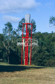 Eltham District Historical Society Inc
Slide - Photograph, Sensory Integration Invention A, Cathy Smith (1999), Fergusons Paddock, Arthurs Creek Road, Hurstbridge, c.Nov. 2001
Sensory Integration Invention A, by Cathy Smith public art sculpture, commissioned by Nillumbik Shire Council, in Fergusons Paddock,12 Arthurs Creek Road Hurstbridge was officially unveiled in 1999. Councillors Penny Mullinar and Margaret Jennings in attendance. "Smith's work has strong references to humans' sensory and practical relationship with the land through the built environment. Wind entering the structure's tubing operates like a flute, generating sounds such as bird calls that resonate into the surrounding wetland areas." Source: Highlights from the Nillumbik Public Art Collection, NSC, n.d. Part of a slide show presentation "A Trip Down the Diamond Creek" by Russell Yeoman to the Eltham District Historical Society meeting of 14 Nov. 200135mm colour positive transparency Mount - Black and Whiteart in public places, arthurs creek road, cathy smith, ferguson's paddock, hurstbridge, public art, sensory integration invention a -
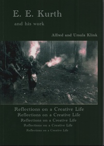 Emerald Museum & Nobelius Heritage Park
Book, Alfred and Ursula Klink, E.E. Kurth and his work, Reflections on a Creative Life by Alfred and Ursula Kling, 2014
Professor Ernest Edgar Kurth of the University of Tasmania, invented a faster, simpler and cleaner way to produce charcoal on a continuous basis during the second world war. The charcoal was used to produce a combustible gas in motor cars, as a substitute for petrol, which was heavily rationed. The first batch of charcoal was produced in February 1942 and continued until the end of the war. Wood from stringybark trees was cut into lengths and fed into a kiln which converted it into charcoal. The Kiln is located on Beenak Road, 7km north of Gembrook. It has great historical significance, particularly as an alternative supplier of fuel during the second world war. It is a State Registered facility, managed by the Friends of Kirth Kiln and the park is managed by Parks Victoria Green soft covered book of 150 pages, with a photo of 2 men and a boy out in the bush with 3 fires burning.Contains a Prelude about Ernest Edgar Kurth written by Alfred Klink (2013) and a Foreward by John Sullivan (Heritage Officer of Parks Victoria). There is an Acknowledgement page, with recognition given to the grant provided by the Department of Sustainability, Environment, Water, Population and Communities. e.e. kurth, kirth kiln, charcoal kiln, parks victoria -
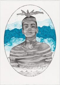 Merri-bek City Council
Lithograph, Megan Cope, Black Napoleon (Eulope), 2019
Working across installation, video and painting, Quandamooka artist Megan Cope investigates issues relating to colonial histories, the environment and mapping practices. Black Napoleon (Eulope) is part of a series of lithographs that highlights what Cope sees as ‘just one of the many stories of powerful and clever people defying Empire’ at the turn of the 19th century in Australia. The Black Napoleon series was produced as part of the Australian Print Workshop’s French Connections project. The project aimed to produce new work responding to the National Archive in Paris, with a focus on cultural materials relating to early exploration of Australia and the Pacific. It was important to Cope that she did not simply repeat the material of the archive, which was collected and conserved within a colonial framework. Instead, Cope’s work addresses Eulope’s sovereignty and role in resisting invasion. Eulope was a Quandamooka man named after Napoleon Buonaparte because of his leadership in battles against British forces, which invaded Stradbroke Island in the early 1800s. -
 Eltham District Historical Society Inc
Photograph - Digital Photograph, Alan King, Downing-Le Gallienne house, Yarra Braes Road, Eltham, 30 January 2008
The property is a classic example of what made Eltham famous from the late 1940s to the 1960s. Covered under Heritage Overlay, Nillumbik Planning Scheme. Published: Nillumbik Now and Then / Marguerite Marshall 2008; photographs Alan King with Marguerite Marshall.; p149 The first view of the large double-storey house at Yarra Braes Road, Eltham South, is of a jutting roofline over a balcony, reminiscent of a large sailing vessel or galleon – very appropriate, considering the name of one of the first owners, Le Gallienne. The Downing-Le Gallienne property is a classic example of what made Eltham famous from the late 1940s to the 1960s and attracted so many artists and intellectuals to the area. Set in a largely indigenous bush-style garden, the mud-brick and timber house was built by Alistair Knox. It was built for economist Richard Downing, to become a founder of the welfare state in Australia and Chairman of the Australian Broadcasting Commission, and musician and composer Dorian Le Gallienne. Le Gallienne was a pioneering composer of modern music in Victoria before 1945, whose works included the Symphony in E.1 He wrote several pieces of film music for Eltham Films, including The Prize, working with its writer and artistic director Tim Burstall. Le Gallienne was also a music critic for The Argus and later for The Age. In 1967 the music critic Roger Covell argued that Le Gallienne’s Symphony, was ‘still the most accomplished and purposive . . . written by an Australian’. According to Alan Marshall the main inspiration behind the building that evolved from 1948 to 1964 was Le Gallienne. ‘He was able to see value in the simplest things and many who worked there had their eyes opened for the first time to the Eltham environment, to the bush and the trees and the fauna which lived there.’ The garden included no formality, no lawns, nor exotic plants. ‘Natural informal growth came right up to their doors and so did the indigenous birdlife.’ This informal style – consisting of mass and void – was to be developed and popularised by landscaper Gordon Ford from the 1950s. The large mud-brick and timber house, which was built in four stages and has three separate but linked sections, began as a small weekend retreat for the couple. In 1948, Downing and Le Gallienne (Dick and Dor to their friends), asked Knox to build the 36 x18 foot (11mx5.4m) building with a pitched slate roof. It was built on a concrete slab and included a fireplace, which is still in use. The second wing was built in 1954 after Downing had returned from working at the International Labour Office and the couple decided to live there full-time. The third section was built after the death of Le Gallienne in 1963, aged 48. He is buried in the Eltham Cemetery. When Downing married widow, Jean Norman (nee McGregor) and had to accommodate a large family, including her six children and one of their own, the last stage was built by 1964. At that time the house was considered one of the largest mud-brick houses in Victoria. It consists of five living areas, including a small ballroom. Several artists helped Knox build the Downing-Le Gallienne house, which was one of his first of mud-brick. They included painter Clifton Pugh, artist John Howley and actor Wynn Roberts. Ellis Stones had landscaped the first wing and Gordon Ford set the boulder steps and made a pool as part of the landscaping he completed. Inside, the mud-bricks are largely whitewashed with pine-lined ceilings and Oregon beams. A winding timber staircase in the front extends behind a glass window from the ground floor to the top. The property, of a little more than 0.5 ha, is bordered by Parks Victoria land, which extends to the Yarra River.This collection of almost 130 photos about places and people within the Shire of Nillumbik, an urban and rural municipality in Melbourne's north, contributes to an understanding of the history of the Shire. Published in 2008 immediately prior to the Black Saturday bushfires of February 7, 2009, it documents sites that were impacted, and in some cases destroyed by the fires. It includes photographs taken especially for the publication, creating a unique time capsule representing the Shire in the early 21st century. It remains the most recent comprehenesive publication devoted to the Shire's history connecting local residents to the past. nillumbik now and then (marshall-king) collection, dorian le gallienne, downing-le gallienne house, eltham, mudbrick construction, mudbrick houses, richard downing, yarra braes road -
 Melbourne Tram Museum
Photograph - Black & White Photograph/s, c1900?
Black and White Photograph of the cable tram Grip mechanism with a piece of cable on a stand in a workshop environment. Has a spanner on a wooden cabinet, that may have allowed a person to stand on and work or test the mechanism. Shows the trip in detail. Photographed onto a glass plate with the words "The 'Grip" used on Melbourne cable tramway cars 30,094 GWW" Printed on Ilford Paper.On rear in pencil "A 2199"trams, tramways, cable trams, grip tram, workshops, cables -
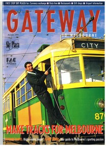 Melbourne Tram Museum
Magazine, Michael Davie, "Gateway - Autumn 1995", "The Lucky City", 1995
Autumn 1995 issue of Gateway with a trammie (Roberto D'Andrea) leaning from 870 on the front cover. Contains an article "The Lucky City", written by Michael Davie about Melbourne and its city, in particular its trams. Has a photo of a City Circle tram (866) on page 22. Gateway published the Federal Airports Corporation as an inbound magazine for overseas travellers. In an email from Roberto 2/10/2014 - "G'day Warren, Yes indeed the Gateway Magazine with a younger Roberto at South Depot. Brings to mind that South Depot did the bulk of the tramways media through the 90s until closure. On the list of programs I have in the archive is Totally Wild (Channel 10), Monty the Weatherman did 4 crosses live (Channel 9), 7.30 Reports (ABC), we hosted 4 Corners around the network and a few other programs on Channel 7. Plenty of newspapers and radio. Handy with a close to city location the PTC sent the media to South for tram stories. I have the 6 Trammie banners from the Trammies Exhibition at the Immigration Museum where we worked together back in 2003. I've used them occasionally and may need them for a tram presentation in March next year....would they be handy as a part of a exhibit at Hawthorn? The Connies are still going strong....festivals and events, sometimes in schools and we've co-funded 2 tram festivals in Kolkata with the Calcutta Tramways in 2012 and 2013....environment central to the themes. Kevin keeps me posted on how things are going at Hawthorn. I met Doug Prosser at Hawthorn a few months ago and all looking good. Kevin sends me copies of The Bellcord....and just last week I was on the Hawthorn Museum website reading about the Box Hill - Doncaster Tram for a Connie performance in Box Hill late in November. Regards - Roberto www.connies.com.au www.tramconductors.net www.tramjatra.net"trams, tramways, city circle, melbourne, tramways, tram 870, tram 866 -
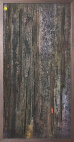 Merri-bek City Council
Mixed media - Callistemon charcoal and ink on marine ply, Brian McKinnon, Bush Fire I “Redgum Sleeper”, 2019