Showing 1615 items matching "zones"
-
 Melbourne Tram Museum
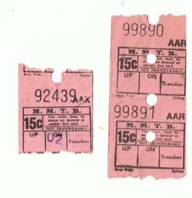
Ephemera - Ticket/s, Melbourne & Metropolitan Tramways Board (MMTB), Set of Ultimate type tickets - 2 x 15c, 1970's?
Type of ticket issued at safety zones in the city by ticket sellers. See item 7850 for a machine and 7889 for instructions.Demonstrates an Ultimate ticket machine ticket.Set of Ultimate type tickets - 2 x 15c in strip on pink paper and 1 x 15c.trams, tramways, tickets, mmtb, ultimate, machine issued tickets -
 Melbourne Tram Museum
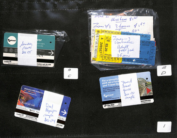
Ephemera - Ticket/s, Metlink, Set of 70 different types or blocks of Melbourne Metcards, 1980's to 2010s
Set of 70 different types or blocks of Melbourne Metcards, passes and associated tickets contained within their own envelope and placed in a heavy duty black folder within photographic sleeves or sheets by the Museum. All collected by Maxwell Hayes, These comprise: Folder Sheet Description 1A Sunday Saver Dec 05 1B Zones 1 to 3 combination Adult - 3 hour 1C Deaffympic games Dec. 04 1D Fares and Travel guide Dec 00 single 2A Safety and Security - Set 4 - Oct. 03 2A Federation May 01 2B Arts Festival 05 2C Melbourne Landmarks July 2000 2D Zones 1 to 3 combination concession - 3 hour 3A Herald Sun - free ticket 3B Art Set 4 Sept 03 3C Arts Festival 05, single Oct 05 3D Worlds Masters games, July 02 4A First issue March 98 4B First issue March 98 with arrows printed on top 4C Celebrity set 10 complete - Set 2 4D Early Bird tickets - wrapped with a Metlink newspaper advert. 5A MMTB / MTA Single Journey 5B Pre Decimal tickets MMTB 5C MMTB Machine tickets 5D Decimal MMTB/ MTA check tickets 6A MetroCard 1981 6B City Savers 6C MMTB Day tripper 6D MTMB/MTA paper tickets 7A Prepurchased Section tickets 7B MMTB Machine generated tickets 7C Monthly travel permits 7D MMTB Railway checks 8A Seniors travel passes 8B Victorian Railways Motor coach 8C Prepaid Travel voucher 8D City Section - concession 9A Misc. - Bus Proprietors Association tickets 9B Night Rider 9C Skybus 9D Neighbourhood Monthly 10A Neighbourhood student passes 10B Zone 1 concession 3 hour 10D Neighbourhood family travelcard 11A Neighbourhood concession 11B Set of 6 Melbourne 2000 Millennium Metcards 11C Melbourne Art Festival 2000 - set of 6 11D Federation Sq Metcard - two sets 12A Melbourne International Comedy festival Metcards 12B Free Internet trial Metcard Oct 1999 - 1 off 12C Two packets of Soccer tickets Metcards 12D Myer Metcard 13A Painted tram launch ticket 13B VR Spirit of Progress Metcard 13C Give blood Metcard May 03 13D Commonwealth Games Metcards Feb 06 14A Private bus lines 14B Melbourne food 2003 15A Neighbourhood full fare and off peak 15B Zone 1 full fare 3 hour 16A Zone full fare 2 hours 16B Neighbourhood travel cards - first issues? 17A Zone 1 to 3 and combinations full fare daily 17B TheatreWorks Travel card - Storming Mont Albert 18A National Bus Company 18B Zone concession - 2 hour 18B Machine issued MMTB - alpha zones 19A Sex (Party line) advertising on reverse 19B Machine issued MMTB Alpha zones 20A Veterans travel passes 20B Special Passes 21 Sample tickets - introduction of photo cards 22 Sample of MTA Gold pins Detail scans of Veterans passes and single journey tickets made - see images i2 to i5trams, tramways, tickets, metcard, metlink, buses, passes, nightrider -
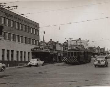
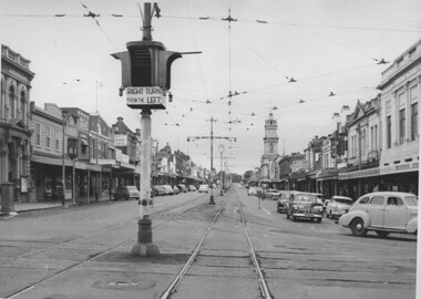 Ballarat Tramway Museum
Photograph - Black & White Photograph/s, Charles Craig, mid 1950's
Photograph of the intersection of Ryrie and Moorabool Streets Geelong looking West along Ryrie St, showing the bar type traffic lights and that right hand turns were done from the left lane. Note the Safety zone sign. Two prints held - one large and one small in a vertical form with the traffic lights featured.. trams, tramways, geelong, ryrie st, moorabool st, traffic lights, safety zone -
 University of Melbourne, Burnley Campus Archives
Map, Melbourne Metropolitan Planning Scheme, c. 1978
Maps showing Zones and Reservations in the Merri Creek area of Melbourne, prepared by the Drafting Department, Planning Branch, MMBW. (1) Map No 36, coloured. (2) Map No 37, coloured. (3) Map No 38, not coloured. (4) Map No 46. Scale 1:9600. May have been used in planning the Native Garden Woodland Area. merri creek, melbourne and metropolitan board of works, melbourne metropolitan area -
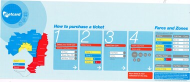 Melbourne Tram Museum
Sign - Adhesive label, Metlink, 2001
Adhesive labels for fitting to a Metcard machines to advise passengers how to purchase Metcard tickets. Shows a Metcard - 3 zone map, which buttons to use and fares effective 1/1/2001. Notes includes GST and provide a contact phone number - no web address. Has the Metcard logo in the top left hand corner.trams, tramways, metcard, metlink, signs, tramcars -
Bendigo Historical Society Inc.
Map - BENDIGO GOLD FIELD GEOLOGICAL MAP
Geological map of the Bendigo Gold Field showing stratigraphical zones. Map in two sections, colour coded showing anticlines, synclines, shafts, fault lines, fossils. Signed by H. Herman. This map forms part of the Geological Survey of Victoria, Structure of Bendigo Goldfield report, No. 47, 1923. H.Herman, late Director of Geological Survey.Geological Survey Victoriabendigo, gold mining, geological map -
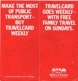 Melbourne Tram Museum
Pamphlet, Minister of Transport, "Travelcard goes weekly with free family travel on Sundays", 1988
Pamphlet - DL size, 2 fold, titled "Travelcard goes weekly with free family travel on Sundays" - gives details of the travel card, to apply from Friday February 5 (but no year - possibly 1988) - three zones post neighbourhood system, with cost of tickets. Notes can be used on trams and buses and where they can be purchased from.trams, tramways, tickets, travel cards, weekly tickets -
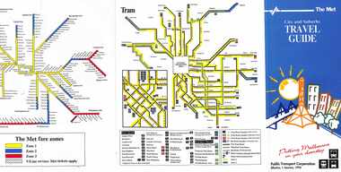 Melbourne Tram Museum
Pamphlet, The Met, "City and Suburbs Travel Guide", 1/01/1993
Pamphlet - 6 fold - titled "City and Suburbs Travel Guide", providing details on The Met ticketing zones, rail and tram maps, including the City Saver area. Extensive details on The Met ticketing system, effective 1/1/1993. .2 - ditto - 7 fold undated - based on fares 1994. 2 copies heldtrams, tramways, ptc, travel promotion, the met, maps, metcard -
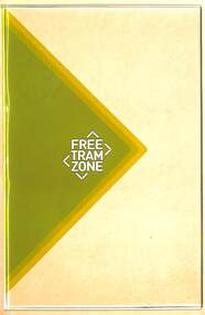 Melbourne Tram Museum
Sign, "Free Tram Zone", Late 2014
Sign - Free Tram Zone logo and background colours printed on a sheet of 5mm clear Perspex. Adam Chandler advised 15/11/2019 - These were prototypes in the office - from memory this was to evaluate the effectiveness of the treatment to tram stop shelter glass (at a much reduced scale)." Unknown sign manufacture - produced for the PTV late 2014.trams, tramways, free tram, signs, shelters, public transport -
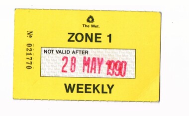 Melbourne Tram Museum
Ephemera - Ticket/s, The Met, Zone 1 Weekly ticket, No. 021770, 1990
Zone 1 Weekly ticket, No. 021770, printed on card, yellow front, white "The Met" safety paper in the validity area, with the Not Valid after "28 May 1990" stamp in large red letters. Has the "The Met" logo on the front, with conditions of use and The Met details on the rear. 950.1 - as above, dated 10 Feb. 1990, No. 007731.trams, tramways, the met, ticket, weekly tickets -
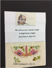 Nhill and District Historical Society Inc.
Postcard - postcard - embroidered April 1916, Memento from France
This postcard was sent from the war zone in France from Hugh Terence O'Reilly to his sister Martha O'Reilly in Nhill.WW1 memorabilia Embroidered post cardCotton thread on silk inset into post card - pink cotton thread dragonfly surrounded by delicate red and blue flowers with green foliage, fames and back with cream cardboardpostcard, ww1 - history, embroidery, australian soldiers, soldiers letters, hugh terence o'reilly, martha o'reilly -
 Ballarat Tramway Museum
Postcard, Biscay Greetings, Bourke St Melbourne
Colour postcard with serrated edges of Bourke St. Melbourne from Parliament house with MMTB Z8 and about 6 W7's in photo, along with many motor vehicles. Also shown are the Safety Zones and stops. In image are buildings along either side of Bourke St., featuring the sign of the Salvation Army City Temple in the top left hand corner, Mittys, and a Kwikasair van by the outbound safety zone. Tram Z8 has destination of "CITY - SPENCER ST." and showing route 89. On rear of card is name of company "Biscay" and caption "New Z class tram in Bourke Street, Melbourne Victoria." and card number BG98 in dark brown ink, along with space for stamp and address. See Destination City re introduction of Z class trams (1975)trams, tramways, bourke st, melbourne, z class trams, tram 2 -
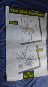 Melbourne Tram Museum
Poster, The Met, "The Met Services", mid 1990's
Poster - full colour on semi gloss paper titled "The Met Services" showing in a diagrammatic form the Melbourne tram and rail routes. For the tram section, (similar to Reg Item 509), shows major street names, route numbers, principal suburbs, terminal names, central area (pre Docklands, post light rail to St Kilda and Port Melbourne) and ticket zones. The rail map section shows the Neighbourhood ticket zones, the rail line via Altona (the direct route is not shown) and shows the St Kilda and Port Melbourne light rail lines. Has The Met logo and the Public Transport Corporation names on the bottom. Mid 1990's, Batman Ave still shown. See also Reg Items 696 and 696 for maps of the time.trams, tramways, melbourne, tramways, tram routes, railways, map, posters, tickets, neighbourhood tickets -
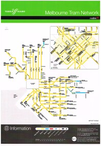 Melbourne Tram Museum
Poster, Yarra Trams, "Melbourne Tram Network", Sep. 2006
Full colour poster, A3 size, printed on laminated sheet - titled "Melbourne Tram Network. Shows a diagrammatic layout of the Melbourne tram system, shows zones (3 zones), CBD, tram terminuses, train station, park and ride locations. Has the Yarra Trams and Metlink logos. Provides contact information including a website. Notes where Metcards are available. Two copies held. Vertical format of Reg Item 719. Dated Effective September 2006. 720.2 - dated Jan. 2005 - shows the Vermont South extension under construction - see image i2. Item added 11-8-2016. 720.3 - undated - prior to Vermont South opened in 2005 - has route 112 and docklands tram line - c2004. Does not have a Yarra Trams logo.trams, tramways, yarra trams, metlink, maps, metcard, vermont south -
 Flagstaff Hill Maritime Museum and Village
Document - Map, Department of Lands & Survey, Victoria / Port Campbell, 1942
This Emergency Edition of the map of Port Campbell, Victoria, is part of the W.R. Angus Collection. It was printed in 1942 during World War II. It is one of two maps donated to Flagstaff Hill Maritime Village by the family of Doctor William Roy Angus, who served as Surgeon Captain in the Australian Defence Department. The map was compiled for the Dept. of Army by the Dept. of Lands and Survey in Melbourne, prepared by the Australian Section of the Imperial General Staff, which was a British Government body created in 1907 to co-ordinate the defence of Britain and its Empire. It was printed by A.H.Q. Cartographic Company, Survey Corps, which was formed in 1941. The Corp changed its name to L.H.Q. Cartographic Company of Bendigo. In 1947 the name reverted back to the A.H.Q. Cartographic Company until 1955 when it became the A.H.Q. Survey Regiment. The W.R. Angus Collection includes historical medical equipment, surgical instruments and material once belonging to Dr Edward Ryan and Dr Thomas Francis Ryan, (both of Nhill, Victoria) as well as Dr Angus’ own belongings. The Collection’s history spans the medical practices of the two Doctors Ryan, from 1885-1926 plus that of Dr Angus who began practice in 1924. Dr Angus served with the Australian Department of Defence as a Surgeon Captain during the Second World Was from 1942 to 1945. He served in Ballarat, Victoria, and in Bonegilla, N.S.W. until he suffering from a heart attack just before the war ended. ABOUT THE “W.R.ANGUS COLLECTION” - Doctor William Roy Angus M.B., B.S., Adel., 1923, F.R.C.S. Edin.,1928, was generally known as Dr Roy Angus. His working life included a position as a doctor with the Flying Doctor Service in Australia’s rural and remote areas. After many varied experiences Dr Angus and his family moved to Warrnambool in 1939 where he purchased “Birchwood,” the 1852 home and medical practice of Dr John Hunter Henderson. He was appointed on a part-time basis as Port Medical Officer in Warrnambool and held this position until the 1940’s when the government no longer required the service of a Port Medical Officer. Dr Angus was a surgeon at the Warrnambool Base Hospital 1939-1942. After further studies he commenced practice as an ophthalmologist in Warrnambool, pioneering in artificial eye improvements. He was Honorary Consultant Ophthalmologist to Warrnambool Base Hospital for 31 years and made monthly visits to Portland to perform eye surgery. Dr Angus and his wife Gladys were very involved in Warrnambool’s community with a strong interest in civic affairs. They were both involved in the creation of Flagstaff Hill Maritime Village, including the layout of the gardens. After his death on 28th March 1970 his family requested his practitioner’s plate, medical instruments and some personal belongings be displayed in the Port Medical Office surgery at Flagstaff Hill Maritime Village, and be called the “W. R. Angus Collection”. This Emergency Edition of the Map of Port Campbell is significant as an example of the documents prepared for the defence of Australia in World War 2. The Map is also significant for its connection between the Australian Army and the involvement of Dr WR Angus as a Surgeon in the Medical Services during World War II. The W.R. Angus Collection is significant for still being located at the site it is connected with, Doctor Angus being the last Port Medical Officer in Warrnambool. The collection of medical instruments and other equipment is culturally significant, being an historical example of medicine, administration, household equipment and clothing from late 19th to mid-20th century. Dr Angus assisted Dr Tom Ryan, a pioneer in the use of X-rays and in ocular surgery. The collection includes Dr Angus’s Army objects and is significant as an example of items issued to Doctors and Surgeons in the Medical Services of the Australian Army in World War IIMilitary map of Port Campbell, Victoria, Australia; part of the W.R. Angus Collection. Rectangular coloured map on cream paper for the Australian Army. Details include sea, waterways and land, contour lines, grid lines, names of districts, towns and roads, bridges, swamps, rail lines, cuttings, tracks, buildings (including blacksmiths), pumps, lighthouses, telegraph, telephones and electric transmission lines, and fire stations. The map has margin notes that include distances in miles to nearby towns. The map was compiled for the Dept. of Army by the Dept. of Lands and Survey in Melbourne, prepared by the Australian Section, Imperial General Staff and printed by A.H.Q. Cartographic Company, Melbourne in 1942. Crown Copyright Reserved. Inscriptions in red print state that it is and Emergency Edition and an Official document. An oval purple stamp includes the price.Printed in black; 'Victoria / Port Campbell", "No. 932 / Zone 6" Printed in red; “EMERGENCY EDITION”, “THIS MAP IS AN OFFICIAL DOCUMENT. IF FOUND, IT MUST BE HANDED / IN TO THE NEAREST MILITARY HEADQUARTERS OR POLICE STATION” Stamped: within concentric ovals (“- - - FOR SALE / PRICE 2/- / - - - - - OF THE ARMY”)flagstaff hill, warrnambool, flagstaff hill maritime museum, maritime museum, shipwreck coast, flagstaff hill maritime village, great ocean road, dr w r angus, dr ryan, warrnambool base hospital, nhill base hospital, flying doctor, surgeon captain, map port campbell 1942, roy angus, port medical officer, military map, emergency map, australian department of defence, royal australian army, military service australian army, department of army, department of lands and survey, world war 2, a.h.q. cartographic company melbourne, australian section, imperial general staff, port campbell 1942 -
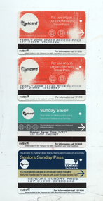 Melbourne Tram Museum
Ephemera - ticket - Yearly and Sunday Metcards, Metlink, 2000s
Examples of tickets issued during the Metcard Era - c1998 to 2013 All have the Metcard and Metlink logos. 1 - Yearly zone 1+2+3 Metcard Access Pass 2 - as above, has printed on rear "Expired" 3 - Sunday Saver - all zones - appears to be unused. 4 - Senior's Sunday Pass - also appears to be unused - see item 2202 for other examples.Demonstrates some of the Metcard tickets issued.Set of four Metcards - printed on a light weight plastic in colour with a magnetic stripe.tramways, tickets, metcard, metlink, seniors card -
 Melbourne Tram Museum
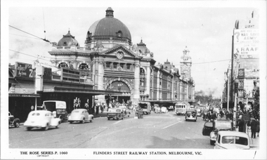
Postcard, Rose Stereograph Co, "Flinders St Railway station Melbourne", c1940
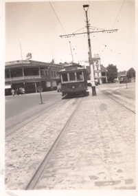
Rose Series postcard No. P 1060, titled "Flinders St Railway station Melbourne," shows a W2 with white war time paint on the bumper bar crossing Swanston Street (Route 28?) with many cars and one horse-drawn cart in the view. On the est bound safety zone stop are several men in military uniforms. Note the eastbound safety zone stop on the east side of Swanston Street. Yields information about the intersection of Flinders and Swanston Sts.Postcard - printed real photograph with Rose Stereograph Co. name on the rear.Has been used as a part letter to Ken Magor.trams, tramways, w2 class, flinders st station, flinders st, swanston st, safety zones, world war ii, princes bridge station -
 Anglesea and District Historical Society
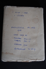
Map, Royal Australian Survey Corps, Anglesea, Victoria, 1954
Anglesea, Victoria [cartographic material] produced by Royal Australian Survey Corps. Colour; Scale [1:63,360] 1 mile to 1 inch; transverse Mercator projection; Sheet No. 866, Zone 7. Two stamps: 1. Rankine and Dobbie Pty Ltd. 2. Authorised for sale / Price 2/- / By Department of the Army Original date: November 1928.(See above)anglesea map, topographic map -
 Whitehorse Historical Society Inc.
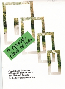
Pamphlet, A Special place to live, 1985 (addendum 1988)
A publication of the City of NunawadingA publication of the City of Nunawading explaining the regulations applying to the Special Residential (Nunawading) Zone No 5. The regulations cover proportions of land which may be built on and identifies trees which must be preserved. An addendum issued in 1988 includes a map of the area and identifies National Trust classified streets in Blackburn and the buffer areas in which less stringent regulations apply.A publication of the City of Nunawadingcity of nunawading, national trust of australia (victoria), special residential (nunawading) zone no. 5, jeffery street, blackburn, laurel grove, linum street, boongarry avenue, hill street, land use, by-laws, town planning, acacia avenue, waratah crescent -
 Ballarat Tramway Museum
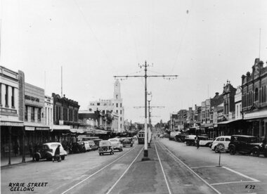
Photograph - Black & White Photograph/s, Late 1940's
Yields information about the appearance of Ryrie Street Geelong and its buildings and vehicles.Black and white photograph of Ryrie Street Geelong Has The title "Ryrie Street Geelong" in the bottom left hand corner and "V.22" in the bottom right hand corner. Shows a safety zone and sign and centre overhead poles. A commercial produced photograph - printer/publisher unknown. See HTD Reg Item 557 for the same image used in an Ashtray.tramways, trams, geelong, ryrie st -
 Melbourne Tram Museum
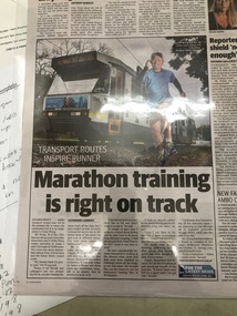
Newspaper, Herald Sun, "Marathon training is right on track", 1/10/2019 12:00:00 AM
"Marathon training is right on track" by Catherine Lambert "Transport routes inspire runner" Cyrus Wong has run along every train line, tram track and most bus routes in zones 1 and 2. Article shows Mr Wong running with tram number 2061 in background. Tram displays route 58, via William St & Zootrams, tramways, tram routes, b class, tram 2061 -
 Ballarat Tramway Museum
Photograph - Bendigo tram 13 Charing Cross, 1950s
Photograph of Bendigo Tram 13, at Charing Cross with the City Club Hotel and the City Family Hotel in the background. A Safety Zone sign can be seen.Yields information about Bendigo tram 13 and Charing Cross during the 1950s. Photograph, black and white on Velox PaperHas Ken Magor stamp and negative number "1723" written in.tramways, trams, bendigo, charing cross, tram 13 -
 Greensborough Historical Society
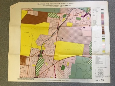
Map, Melbourne and Metropolitan Board of Works Interim Development Order 1961 Map No. 53, 27/09/1961
Denotes Zones and Reservations comprising part of the municipalities of Eltham, Heidelberg, Preston and Whittlesea, approved 27.9.61. Includes Mont Park Hospital and Watsonia Military Camp.Colour plan Date printed on plan (1959) has been over stamped with 1961. Also stamped with Government Gazette date of 27.9.1961. "Scale 800 feet to 1 inch"greensborough, watsonia -
![Newspaper - Newspaper clipping, [Age], [Wednesday, 10 January, 1945]](/media/collectors/64a5077bc83bd7b7b94f4211/items/66fbe018d736c6f9db2104fe/item-media/66fbe09fd736c6f9db21060d/item-fit-380x285.jpg) Returned Nurses RSL Sub-branch
Returned Nurses RSL Sub-branchNewspaper - Newspaper clipping, [Age], [Wednesday, 10 January, 1945]
Photograph with caption 'Sisters of the Australian / Army Nursing Service / leaving Melbourne yester- / day for service in a / northern zone. Judging / by their happy smiles / they are pleased at the / prospect.'Newspaper clipping of a photo with caption'NC9'wwii, world war ii, world war two, australian army nursing service -
 Bendigo Historical Society Inc.
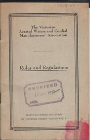
Document - COHN BROTHERS COLLECTION: BUSINESS PAPERS, 1924 - 1951
Document. Cohn Bros. Collection. 1 - Black exercise book containing business papers and notes from meetings. 2 - Price list and zones for drinks and deposits on containers/bottles. 3 - The Victorian Aerated Waters and Cordial Manufacturer's Association Rules & Regulations (received 15 Jan 1942). 4 - Buff folder containing papers relating to business and price of drinks.organization, business, cohn bros, cohn bros. collection, brewers, cordial & aerated water manufacturers, the victorian aerated waters and cordial manufacturer's association -
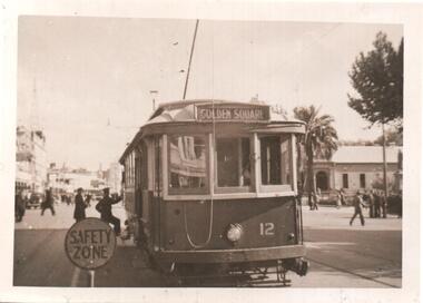 Ballarat Tramway Museum
Photograph - Black & White Photograph/s, Lee A Ratten, late 1940's to early to mid 1950's
Black and white photograph of Bendigo 12 in Pall Mal, the stop before Charing Cross. Tram stop has a safety zone sign and two crew members at the front of the tram. Photograph late 1940's to early to mid 1950's. Tram has the destination of Golden Square. Photo possibly Lee A Ratten - see related document and Reg Item 7185.trams, tramways, bendigo, pall mall, safety zone, tram 12 -
 Ballarat Tramway Museum
Photograph - Black & White Photograph/s, Charles Craig, mid 1950's
Photograph of the intersection of Ryrie and Moorabool Streets Geelong looking south along Moorabool St, with two bogie trams in Ryrie St, both with safety or hazard stripes. Trams have the destination of Belmont and North. Has the Bank of NSW in the view, E. A. O'Meara Chemist advertising Kodak film and the Geelong Nursery Nook. Adjacent to the tram for Belmont is the safety zone sign. trams, tramways, geelong, ryrie st, moorabool st, traffic lights -
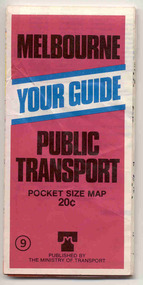 Ballarat Tramway Museum
Map, Ministry of Transport, "Melbourne Public Transport Map" - "No. 9", 1979
Pocket size - folded - public transport map of Melbourne, printed in colour on paper, showing public transport services in greater Melbourne and an index of localities. The Central zone area shown in detail. On the rear, route numbers and line maps of tram routes and train lines or services. Includes private bus routes. Printed for the Ministry of Transport. Issue No. 9. Dated 1979.trams, tramways, melbourne, map, routes -
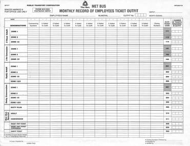 Melbourne Tram Museum
Document - Form/s, Public Transport Corporation (PTC), "The Met (Met bus) – monthly record of employees ticket outfit ", late 1980's?
Printed form on off white paper with yellow self carboning copy (NCR) titled "The Met (Met bus) – monthly record of employees ticket outfit ", listing employees names, number, day, and the various zone travel tickets including "The Met Bus special ticket". Apparently for use at Footscray Depot. Form No. MBTAF1 and F/PTC01117A. Possibly late 1980's.trams, tramways, mmtb, passengers, tickets, forms, revenue journal, buses -
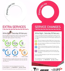 Melbourne Tram Museum
Pamphlet, Public Transport Victoria (PTV), "Service Changes - White Night", Feb. 2017
Pamphlet - 2 fold full colour printed cut to hang over a grab rail on a tram advertising Service Changes for the White Night event, 18 Feb. 2017 and providing details of extra tram, bus and train services. Has a map showing the White Night Zone and where services could be found. Has Victorian Government, Yarra Trams and PTV logos.trams, tramways, night trams, public transport, ptv, events, melbourne