Showing 10388 items
matching plan
-
 Port Melbourne Historical & Preservation Society
Letter - Tom Roper, Minister for Planning and Environment to Evan Walker, Minister for Major Projects re Bayside EES Inquiry, Ewan Ogilvy's Bayside Papers, Box One, 1987 - 1998
Ewan Ogilvy, former Melbourne Councillor and also of Community Services Victoria, Inner Urban Ministerial Advisory Committee and Uniting Church's Centre for Urban Research and Action (CURA), was instrumental in social justice approaches to town planning. He and CURA's Social Justice and the City Project funded Port Melbourne community groups protesting against the SCDC development in 1987. His files were presented to the Society in May 2001 on his preparation for leaving Victoria.From Ewan Ogilvy's chronologically organised 'Bayside Papers' relating to the proposed development of Port Melbourne industrial land in the late 1980s: Ministerial correspondence from Tom Roper, Minister for Planning and Environment to Evan Walker, Minister for Major Projects, related to panel's decision on Bayside EES Inquiry 1997/8, included in bound black fileAll items signed 'Ewan Ogilvy'town planning, town planning - proposals shelved - bayside, public action campaigns, environmental issues, public housing, missions to seamen, ewan ogilvy, centre for urban research and action, sandridge city development comapny, tom roper, evan walker -
 Melbourne Tram Museum
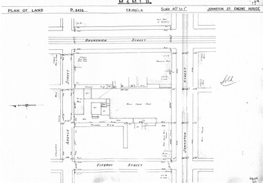
Drawing, Melbourne & Metropolitan Tramways Board (MMTB), "Johnston St Engine House", "Northcote Engine House", "Richmond Engine House", c1938
Set of four photocopied plans or drawings on A3 sheet of the "Johnston St Engine House", "Northcote Engine House" and "Richmond Engine House", c2/1938. .1 - Sheet 1 - P8498 - Plan showing land and surrounding streets for the "Johnston St Engine House" .1 - Sheet 2 - P8499 - Plan showing the layout of the engine house. Has a note sheets 1 and 2 that it has been sold .2 - P8506 -Plan showing land and surrounding streets for the "Northcote Engine House" - 2 copies held. .3 - P8607 - Plan showing Richmond Engine House and adjacent streets with sub-station next doortrams, tramways, drawings, depots, property, cable trams, winding houses, johnston st, northcote, richmond, hoddle st, bridge rd -
 Federation University Historical Collection
Plans, Six plans for the Central Highlands Regional Library Services Headquarters, and Ballarat City Library, 1993
Six printed architectural plans on paper: .1) .2) .3) Plan levels 1, 2, 3 .4) Sections aa-bb .5) North and south elevations .6) East and west elevationsarchitecture, central highlands, central highlands regional library, ballarat city library, plans -
Port Melbourne Historical & Preservation Society
Book - Community Services Centre, Planning Document, 1992
Community Services Centre. Planning Document 1992. Detailed planning document to co-ordinate community services and, in particular, to meet the changing needs of residents. City of Port Melbourne 1992. Blue front pagelocal government - city of port melbourne -
Tatura Irrigation & Wartime Camps Museum
Book, Department of Agriculture Victoria, Institute for Sustainable Agriculture, 1993
Investigation of salinity problems by staff at Tatura, Kyabram, Shepparton, and Cobram Institutes.Department of Agriculture photos on front. Saline waterlogged land near Shepparton. Measuring white clover growth. Salinity management plans for research. Farm planning blueprint. Satellite image of plains and Lodden river.salinity, department of agriculture, kyabram, tatura, shepparton, cobram -
University of Melbourne, Burnley Campus Archives
Plan, Ellis Stones Rockery, 1962-1999
(1) Note by Phil Tulk, Gardens Manager, c. 1999 re Restoration of the Ellis Stones Rockery originally planted in 1962. (2) 3 photocopies of Ellis Stones' original plant list. (3) 2 photocopies of a hand drawn planting plan, 1 has names of plants written in pencil, the other just has numbers with no key attached. (4) Handwritten list with descriptions of plants. Also see B15.0527 (Documents B0x 73 for more information re planting plan. Also numerous photographs.gardens manager, phil tulk, rockery -
University of Melbourne, Burnley Campus Archives
Plan, School of Primary Agriculture & Horticulture - Burnley, c. 1925-1926
Copy of plan photographed at the Public Records Office Victoria. Central Administration Correspondence Files 1912-1939 ITEM. VPRS 10163/P0003/2. Accomodation Burnley School Part 1. Traced from M.M.B.W. Plan No. 42. Scale 160 ft=1 in. Level Datum L.M.N. Hobson's Bay. Traced by C.E.B.W. 16.02.1926. Additional matter in red and green inserted by F.E.T.C. 09.02.1926. Note by J.J. Rae (Principal). Lists W.C.s (toilets). Shows 1891 Flood Line. Possibly dates from 1925.prov, school of primary agriculture and horticulture, burnely, j.j. rae -
University of Melbourne, Burnley Campus Archives
Plan, New School of Primary Agriculture & Horticulture Burnley Gardens, 1945
Photocopy of Plan of the Administration Building by the Chief Architect dated 26.9.45. Scale 1/8 inch - 1 foot. Photocopy reduced in size from original. (1) Ground Floor and First Floor Plans. (2) West Elevation, Longitudinal Section 'B-B' and East Front Elevation. (3) Flat Roof, Library and Herbarium. (4) Common Room and Assembly Hall. Originally in the Burnley Archives. Property and Service now have the original and gave the reduced size photocopy to the Archives. Hard to read now.burnley gardens, school of primary agriculture and horticulture -
Federation University Historical Collection
Plan, Ballaarat Common, 1898
Plan showing Ballaarat Common, Police Reserve, Industrial School Reserve, Cattleyards Railway, Powder Magazine, Scarsdale and Ballarat Railway, Ararat and Ballarat Railway and Mr Comries House. Robert Davidson was the surveyor. WGS 84ballaarat common, police reserve, industrial school reserve, cattleyards railway, powder magazine, scarsdale and ballarat railway, ararat and ballarat railway, comrie, ballarat common, robert davidson, ballarat industrial school -
Port Melbourne Historical & Preservation Society
Plan - Annotated and handcoloured by Peter Libbis to indicate his research into Libbis family residences and hotels on copy of a section of an MMBW map, Melbourne and Metropolitan Board of Works, c. 1980s
Peter LIBBIS obtained these copies from the MMBW when he researched his family history in the 1980s. He has annotated them, colour in hotels etc. Donated to Society in 1997.One of a group of 19 photocopies of various 20th century MMBW plans, annotated/coloured in to indicate residences of Libbis family and local hotels, by Peter LIBBIS in family and hotel research - Cricket ground, Bridge to Ingles - 1950s?business and traders - hotels, built environment - domestic, transport - railways, melbourne and metropolitan board of works, libbis family -
Port Melbourne Historical & Preservation Society
Plan - Annotated and handcoloured by Peter Libbis to indicate his research into Libbis family residences and hotels on copy of a section of an MMBW map, Melbourne and Metropolitan Board of Works, c. 1980s
Peter LIBBIS obtained these copies from the MMBW when he researched his family history in the 1980s. He has annotated them, colour in hotels etc. Donated to Society in 1997.One of a group of 19 photocopies of various 20th century MMBW plans, annotated/coloured in to indicate residences of Libbis family and local hotels, by Peter LIBBIS in family and hotel research - North Port Station, Ingles to Bridgebusiness and traders - hotels, built environment - domestic, transport - railways, melbourne and metropolitan board of works, libbis family -
Port Melbourne Historical & Preservation Society
Plan - Annotated and handcoloured by Peter Libbis to indicate his research into Libbis family residences and hotels on copy of a section of an MMBW map, Melbourne and Metropolitan Board of Works, c. 1980s
Peter LIBBIS obtained these copies from the MMBW when he researched his family history in the 1980s. He has annotated them, colour in hotels etc. Donated to Society in 1997.One of a group of 19 photocopies of various 20th century MMBW plans, annotated/coloured in to indicate residences of Libbis family and local hotels, by Peter LIBBIS in family and hotel research - Bay/Crockford area, Ingles to Bridgebusiness and traders - hotels, built environment - domestic, transport - railways, melbourne and metropolitan board of works, libbis family -
Port Melbourne Historical & Preservation Society
Plan - Annotated and handcoloured by Peter Libbis to indicate his research into Libbis family residences and hotels on copy of a section of an MMBW map, Melbourne and Metropolitan Board of Works, c. 1980s
Peter LIBBIS obtained these copies from the MMBW when he researched his family history in the 1980s. He has annotated them, colour in hotels etc. Donated to Society in 1997.One of a group of 19 photocopies of various 20th century MMBW plans, annotated/coloured in to indicate residences of Libbis family and local hotels, by Peter LIBBIS in family and hotel research - Pickles/Crockford (South Melbourne mostly)business and traders - hotels, built environment - domestic, transport - railways, melbourne and metropolitan board of works, libbis family -
Port Melbourne Historical & Preservation Society
Plan - Annotated and handcoloured by Peter Libbis to indicate his research into Libbis family residences and hotels on copy of a section of an MMBW map, Melbourne and Metropolitan Board of Works, c. 1980s
Peter LIBBIS obtained these copies from the MMBW when he researched his family history in the 1980s. He has annotated them, colour in hotels etc. Donated to Society in 1997.One of a group of 19 photocopies of various 20th century MMBW plans, annotated/coloured in to indicate residences of Libbis family and local hotels, by Peter LIBBIS in family and hotel research - Crockford to Montague (South Melbourne mostly)business and traders - hotels, built environment - domestic, transport - railways, melbourne and metropolitan board of works, libbis family, thomas curran -
 Whitehorse Historical Society Inc.
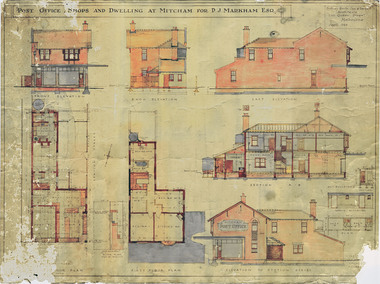
Plan - Architect Drawings, Mitcham Post Office, 1/04/1923 12:00:00 AM
Post office shops and dwelling at Mitcham for P. J. Markham, Esq. [Plans and elevations].Plans and elevations for the Post office shops and dwelling at Mitcham for P. J. Markham, Esq. Sydney Smith, Ogg & Serpell, Architects, 1923. Original and preservation copy. Digital image held on DVD: see NP 3949non-fictionPost office shops and dwelling at Mitcham for P. J. Markham, Esq. [Plans and elevations].mitcham post office, markham, patrick joseph -
 Bendigo Historical Society Inc.
Plan - Great Extended Hustlers, April, 2014
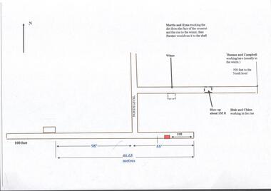
Seven men were killed at the Great Extended Hustler's mine disaster on 2nd May 1914 by an explosion of dynamite occurring as the men were waiting at the plat to ascend the mine at the end of their shift. No blame was attached to anyone in the findings of the inquisition. It was unknown what caused the dynamite to explode. This document formed part of the research done at the time by Bendigo Historical Society, of the 100 years commemoration of the mine disaster, held at Hustler's Hill in 2014. One page plan, computer generated, annotated to show the worksite of the miners prior to when the explosion occurred at the Great Extended Hustlers mine in May 1914. The location of Martin, Ryan, Thomas, Campbell, Blair and Chinn are described. great extended hustlers, goldmining, accident, 1914 -
University of Melbourne, Burnley Campus Archives
Plan, C.E. Richardson, Burnley Gardens, 1965
5 printed plans with buildings marked in black. Drawn by C.E. Richardson, P.R.L. 6th August, 1965, amended 1st December, 1965. Marked: Project No 1 (Engineering Building) and Project No 2 (Plant Sciences Building.) burnley gardens, buildings, burnley school of horticulture -
University of Melbourne, Burnley Campus Archives
Plan, Proposed Stores & Garage Renovations, 1997
Burnley Development Site for Amrad Operations Pty. Ltd. By Johnston Merat Kurdiovsky Pty. Ltd. Dated March 1997. Scale 1:100. (1) Site Improvements Plan. (2) Elevations - Building & Fence Treatment.amrad, burnley, stores, garages, johnston merat kurdiovsky p/l -
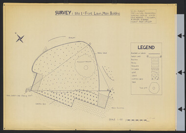 University of Melbourne, Burnley Campus Archives
Plan, Survey: Site 1 - Front Lawn, Main Building, 1985
Plan of Front Lawn area with legend. V.C.A.H - Burnley Horticultural Engineering Surveying Exercise dated 10.09.1985. Group Members: T. Allworth, M. Appleby, B Barker (Student: Mary Appleby). Scale 1:100.vcah, lawns -
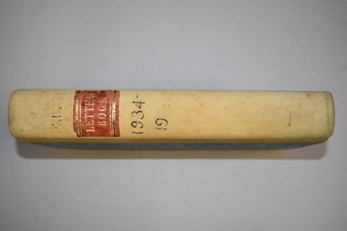 Warrnambool and District Historical Society Inc.
Letter book, J & R Crawley, 1934
This letter book contains letters, sketch maps and plans and dates from1934 to 1936. It originally came from the office of John William Crawley Junior, an engineer, surveyor and architect in private practice in Warrnambool and also the Shire Engineer for the Shire of Warrnambool from 1895 to 1935. His father, brother and son were also engineers and worked in that capacity or as the Shire Secretary for the Shire of Warrnambool, with the Crawley family recording a total of 132 years of service to the Shire. The Shire of Warrnambool existed from 1863 to 1994. The letter book was also used in the private practice of John Crawley’s son, Rolf who was the engineer for the Shire of Warrnambool from 1935 to 1968. The letter book then came into the possession of Michael Hand who took over the private surveying business of Rolf Crawley in Warrnambool. The Warrnambool and District Historical Society acquired the letter book, along with several other Crawley ledgers, from the estate of Michael Hand.This letter book is of considerable significance as it contains letters written by John Crawley and Rolf Crawley who were in an engineering, surveying and architects private practice in Warrnambool over the time covered in the book. It will be very useful to researchers. This is a hard cover book of 1000 pages but only 354 pages have been used. The cover is bound at the corners and on the spine with buff-coloured leather. The book contains an alphabetical index, handwritten letters, sketch maps and plans. ‘Private Letter Book 1934- 19.’ ‘R.L./J. W. Crawley Private’ john william crawley junior, warrnambool, rolf crawley, warrnambool, shire of warrnambool -
 Kew Historical Society Inc
Plan - Subdivision Plan, Old Kew Golf Links Estate - Third Section, 1920-1929
Pru Sanderson, in her groundbreaking ‘City of Kew Urban Conservation Study : Volume 2 - Development History’ (1988), summarised the periods of urban development and subdivisions of land in Kew. The periods that she identified included 1845-1880, 1880-1893, 1893-1921, 1921-1933, 1933-1943, and Post-War Development. These periods were selected as they represented periods of rapid growth or decline in urban development. An obvious starting point for Sanderson’s groupings involved population growth and the associated economic cycles. These cycles also highlighted urban expansion onto land that was predominantly rural, although in other cases it represented the decline and breakup of large estates. A number of the plans in the Kew Historical Society’s collection can also be found in other collections, such as those of the State Library of Victoria and the Boroondara Library Service. A number are however unique to the collection.The Kew Historical Society collection includes almost 100 subdivision plans pertaining to suburbs of the City of Melbourne. Most of these are of Kew, Kew East or Studley Park, although a smaller number are plans of Camberwell, Deepdene, Balwyn and Hawthorn. It is believed that the majority of the plans were gifted to the Society by persons connected with the real estate firm - J. R. Mathers and McMillan, 136 Cotham Road, Kew. The Plans in the collection are rarely in pristine form, being working plans on which the agent would write notes and record lots sold and the prices of these. The subdivision plans are historically significant examples of the growth of urban Melbourne from the beginning of the 20th Century up until the 1980s. A number of the plans are double-sided and often include a photograph on the reverse. A number of the latter are by noted photographers such as J.E. Barnes.When the old Kew Golf Links was subdivided in the mid 1920s, the developers were able to break the sale into sections. The third section included eighty lots. The lots faced Kilby Road, Kodak Avenue, Belford Road, Baker Avenue, Mathers Avenue, and White Avenue. [Kodak Avenue was renamed Page Avenue at a later date].The ‘Kew Conservation Study (1988) notes that ‘On the subdivision plan, Kodak’s involvement is commemorated by the naming of the streets after Company directors, and their decision to not proceed with the construction of the factory is explained as a response to the increase in the value of the land. This explanation may have been Estate Agent’s hyperbole, as the Kodak Company records suggest that the land, with its wide creek gully, was unsuitable and too small for its purposes.subdivision plans - kew, old kew golf links estate - third section -
Federation University Historical Collection
Book, A Descriptive Catalogue of the Minerals in the Museum of the School of Mines, Ballaarat, 1882, 1882
The Museum of the Ballarat School of Mines was established in 1872. The curator in 1882 was Ferdinand M. Krause. Prefatory Notice by James Oddie). The want of a guide through the technical collections of The School Mines has long been felt by visitors and students - a guide , not so much to those who merely 'look' at the various exhibits in the Museum, but an instructor to those who desire to take away with them some practical information on the natural occurrence and economical value of the objects exhibited. This want is being filled by the labour of Mr. Krause, whose first installment - 'A Descriptive Catalogue of the Minerals' - is herewith represented to the visiting public." Introduction to the catalogue: " The collection is still in its early growth, and far from being a complete representation of the Mineral Kingdom; many varieties, species, and even whole groups are absent. This state of incompleteness will, no doubt, be adjusted in the sequence, and progressive lists issued from time to time. 'Ad interin' the present catalogue will, be found useful to students and visitors of the School. As far as practicable, the classifications of the minerals accords with that adopted at the Royal School of Mines, London. The numbers prefixed to the species in the catalogue agree with those on the descriptive labels which accompany each specimen, and also with those attached to the specimens themselves. On the descriptive labels the chemical composition of the minerals is expressed in formulae usually employed in standard mineralogical works. Students who have note paid attention to mineralogical chemistry will note that each dot over a symbol is equivalent to one atom of oxygen, .... A bar through a symbol denotes a double atom of the base, .... " In 1882 the collection was housed in 33 cases. The catalogue outlines the specimen types housed in each case. The classification of minerals accords with that adopted at the Royal School of Mines, London. Leather covered book of 94 pages with gold lettering on the front, including "F.M. Krause". The book includes a plan of the museum layout, plan of the grounds and buildings of the Ballarat School of Mines and a prefatory notice by James Oddie.ballarat school of mines, ballarat school of mines museum, museum, krause, ferdinand krause, fm krause, oddie, james oddie, geology, mineralogy, charles boyd, f.m. krause, minerals, curator -
Bendigo Historical Society Inc.
Book - FIRE WARDEN'S RECORD BOOK, 1928
Fire Warden's Record Book. Contains detailed drawings and plans for fire services for buildings in Bendigo CBD. Rescued from the Killian's Walk fire by the Donor. Cardboard covers with plans inside. Very poor condition.bendigo, fire brigade, fire warden's books -
Port Melbourne Historical & Preservation Society
Map - MMBW, 1897
Melbourne and Metropolitan Board of Works 1895, Plan No. 324, 328, 329 Segments shown: (as plan No's.) Large scale showing hotels, civic and industrial buildings, Graham Street to Bay, Nott and Dow Streets.engineering - board of works, business and traders - hotels, built environment, piers and wharves - town pier, transport - tramways -
 Bendigo Historical Society Inc.
Document - MCCOLL, RANKIN AND STANISTREET COLLECTION: NAPOLEON REEF GOLD MINING CO. N.L, 2 May 1940
Document: Prospectus of Napoleon Reef Gold Mining Company, 8 pages plus plan of portion of Napoleon Line of Reefs and plan of transverse section of lease No. 10970, Capital: £30,000 in 60,000 shares of 10/- each.organization, business, industrial - mining, mccoll rankin & stanistreet, mining, gold mining, napoleon reef -
 Bendigo Historical Society Inc.
Document - GERTRUDE PERRY COLLECTION: HOUSE SKETCHES
Two pencil drawings. the first one of the outside of a house and the words; 'This is how your design would look darling". Semi-plan view. "I'd say you are pretty beaut". the second drawing is a plan of the inside.house, private, drawings -
Whitehorse Historical Society Inc.
Letter - Correspondence, Appeal against brothel proposal, 29/08/1985 12:00:00 AM
Letter from Registrar, Planning Appeals Board to Yarramalong Valley Pty Ltd re proposes brothel at Thornton Cres, Mitcham.Letter from Registrar, Planning Appeals Board to Yarramalong Valley Pty Ltd re proposes brothel at Thornton Cres, Mitcham. Also notice of appeal, grounds of appeal and Planning and Appeals Board Act 1980.Letter from Registrar, Planning Appeals Board to Yarramalong Valley Pty Ltd re proposes brothel at Thornton Cres, Mitcham. brothels, yarramalong valley pty ltd, thornton crescent, mitcham, no 25, victoria. planning appeals board, galbally & o'bryan -
University of Melbourne, Burnley Campus Archives
Work on paper (item) - Student Work, Anton Bialylew, Kneebone Project Landscape Design, Uncertain, probably 2017-2018
Made as an assignment for HORT90035, a subject at Burnley Horticultural College coordinated by Andrew Laidlaw. -
Canterbury History Group
Ephemera - Shrublands, 16 Balwyn Road Canterbury, 1/10/2004 12:00:00 AM
Real estate advertisement for the sale by auction of the historic mansion "Shrublands" 16 Balwyn Road Canterbury on 5 October 2002. Includes coloured photographs of the exterior of the house and floor plans for both floors and site plans.canterbury, balwyn road, shrublands, victorian italianate style, verandahs -
Glen Eira Historical Society
Plan - Wilks Street, 17, Caulfield North
Drawn plan of house at 17 Wilkes Street Caulfield with room dimensions, squarage and content, and fixtures with tenants name J. Barrett.caulfield north, wilkes street, barrett j., brick houses