Showing 123966 items matching "main-road"
-
 Eltham District Historical Society Inc
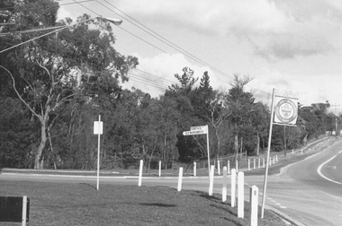
Photograph, Liz Pidgeon, Heritage Excursion; East of Eltham, 6 Sep 2014, 20 May 2017
Newsletter No. 218, September 2014 September Excursion - East of Eltham Walk In Newsletter No. 197, March 2011, there was a brief history of Crown Allotment 15 Section 5 Parish of Nillumbik (CA 15) a parcel of land of a quarter of a square mile extending from Eucalyptus Road to Reynolds Road at the eastern extremity of Eltham. From the 1940s it was known as Stokes orchard. In later years it has been subdivided for residential purposes but leaving significant areas as power line and water supply reserves and bushland reserves that are habitat for the threatened For our excursion on 6th September we intend to walk through CA 15 to a bushland reserve east of Reynolds Road. The walk will traverse the boundary between suburban Eltham and the non-urban areas to the south and east. This is a pleasant walk through residential areas and bushland. Along the way we will discuss the early and more recent history of CA 15 as well as local natural history and geology. This walk is about 3.5 km in length and will take 2 to 2.5 hours. It will start at 2pm at the corner of Eucalyptus Road, Pitt Street and Nyora Road.Born Digitaleltham east, eltham district historical society, heritage excursion, activities, nyora road, reynolds road, gum tree road reserve, diosma road, stokes orchard, eucalyptus road -
 Eltham District Historical Society Inc
Photograph, Liz Pidgeon, Heritage Excursion; East of Eltham, 6 Sep 2014, 20 May 2017
Newsletter No. 218, September 2014 September Excursion - East of Eltham Walk In Newsletter No. 197, March 2011, there was a brief history of Crown Allotment 15 Section 5 Parish of Nillumbik (CA 15) a parcel of land of a quarter of a square mile extending from Eucalyptus Road to Reynolds Road at the eastern extremity of Eltham. From the 1940s it was known as Stokes orchard. In later years it has been subdivided for residential purposes but leaving significant areas as power line and water supply reserves and bushland reserves that are habitat for the threatened For our excursion on 6th September we intend to walk through CA 15 to a bushland reserve east of Reynolds Road. The walk will traverse the boundary between suburban Eltham and the non-urban areas to the south and east. This is a pleasant walk through residential areas and bushland. Along the way we will discuss the early and more recent history of CA 15 as well as local natural history and geology. This walk is about 3.5 km in length and will take 2 to 2.5 hours. It will start at 2pm at the corner of Eucalyptus Road, Pitt Street and Nyora Road.Born Digitaleltham east, eltham district historical society, heritage excursion, activities, nyora road, reynolds road, gum tree road reserve, diosma road, stokes orchard, eucalyptus road -
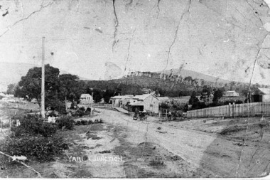 Upper Yarra Museum
Negative Photographic Reproduction, Main St Yarra Junction
03042 Main street opposite the railway station, 1909, Yarra Junction. Upper Yarra Shire 1888-1988 Centenary collection. Black & white Negative, scanned at 600 dpiearly main street yarra junction -
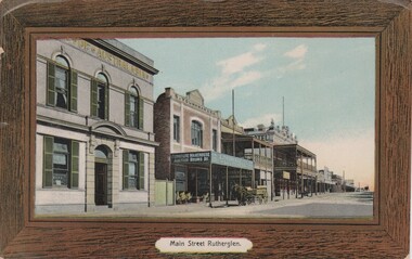 Rutherglen Historical Society
Image, W. Hine Bookseller, Main Street, Rutherglen, c1890
Coloured postcard photograph, in a brown printed frame, showing Main Street, Rutherglen looking west. Photo features the Bank of Australasia, S. Younkman's Auction Rooms and the Victoria Hotel.main street rutherglen, bank of australasia, s younkman & co, victoria hotel -
 Lakes Entrance Historical Society
Postcard, Bruthen Cottage Hospital Main Street Bruthen Victoria, 1910 c
Sepia toned postcard of early Bruthen showing main street going left to right with Commercial bank seen in centre Bruthen Victoria. Also black and white enlargedment.1township -
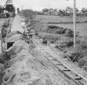
 Eltham District Historical Society Inc
Photograph, Russell Yeoman, Construction of fire access on Gumtree Road, Research, by Army Reserve Engineers under command of Captain Bill Oakley, c.1966, 1966c
Bill Oakley was an engineer at the Shire of Eltham. Viewed from west looking east. Road had more zigs and zags in those days on the west side. Russell Yeoman's FC Holden visible at bottom of hill. Digital file only; created from original colour positive slide transparencyresearch (vic.), russell yeoman collection, gumtree road, army reserve engineers, captain bill oakley, fc holden sedan, fire access, streets -
 Tarnagulla History Archive
Postcard - Photographic postcard: Commercial Road, Tarnagulla looking south from Poverty Street, c. 1910
Williams Family Collection. Photographic postcard, front image depicting Commercial Road, Tarnagulla looking south from Poverty Street. Handwritten on reverse: '1/2 main street, Commercial Road, Tarnagulla' and 'L.Williams Tarnagulla'tarnagulla -
 Ringwood and District Historical Society
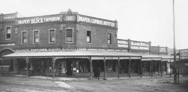
Photograph, Maroondah Highway Central, Ringwood. Bloods Emporium, Cnr. Main St. and Adelaide St. Ringwood- c1924
Black and white photograph (2 copies)Typed below one photograph: "Bloods Emporium - Cnr. Main St. and Adelaide St. (Now parking area for Eastland) 1924". -
 Ringwood and District Historical Society
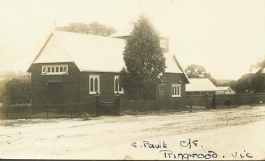
Photograph, St. Paul's in original position, Cr. Main & Pratt St. Ringwood (pre 1924)
Black and white photograph of church.Typed below photograph and written on backing sheet, "St. Paul's in original position, Cr. Main & Pratt St. Shifted in 1924". -
 Ringwood and District Historical Society
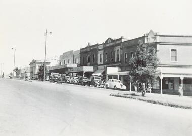
Photograph, Maroondah Highway Central, Ringwood. Corner of Main and Adelaide Streets, 1949
Black and white photograph (2 copies- 1 large, 1 small)Written on backing sheet: "Corner of Main and Adelaide St. 1949". Image shows shops between Adelaide Street and Melbourne Street. -
 Ringwood and District Historical Society
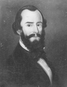
Photograph, Self portrait of Mr. Pierce Boardman, Manager of Ringwood's main antimony mine. (undated but pre 1879)
Black and white photographTyped below photograph: "Self portrait of Mr. Pierce Boardman, Manager of Ringwood's main antimony mine. Killed in mine, 1879". -
 Ringwood and District Historical Society
Photograph, Intersection of Tortice Dr. Old Warrandyte Road and Warrandyte Road 1981
Written on back of photograph, "19/6/81. Intersection of Tortice Dr. Old Warrandyte Road and Warrandyte Road (on right)." -
 Surrey Hills Historical Society Collection
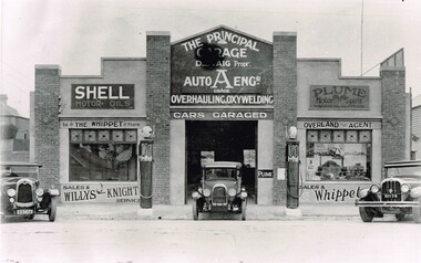
The Principal Garage at 260 Canterbury Road, Surrey Hills, After 1927
David Staig Jnr established this business in 1927 on the corner of Canterbury Road and Revers Street. He lived at 355 Canterbury Road, one of a series of shops (with living accommodation) owned and built in c1885 by Thomas C Hyde. G Staig (farmer) was the first in the family to occupy this, followed by James Staig (carpenter), then David Staig Snr (blacksmith) and David Staig Jnr. Bill Steiner was the chief mechanic at The Principal Garage; his apprentice Frank Senior eventually bought the business from David Staig and it became Senior's Garage. In 2020 there is a Shell service station and a Coles Express on the site. The Staig family were long-time residents of the area and this photo documents part of their business history. Dave Staig, who established this business, was an early aviator who designed and built his own plane.Black and white photo of a classic 1920's era garage build in brick and render and with 2 petrol bowsers on the curbside, either side of the central garage entrance. Advertising on the facade indicates Shell and Plume motor oils. There are 3 cars positioned in such a way that suggests this may have been a publicity photo. Advertising on the facade indicates that cars could be garaged at the facility and that the proprietor was D. Staig. It also indicates that the business was an agent for The Whippet car, the Willys-Knight car and the Overland car.principal garage, senior's garage, senior's motors pty ltd, garages, redvers street, canterbury road, david staig jnr, bill steiner, frank senior -
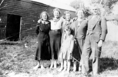
 Eltham District Historical Society Inc
Photograph, Frank Stokes with daughters Dorothy (left) and Beryl (right) at Stokes Orchard, Nyora Road, Eltham, 1944, 1944
Frank Stokes first traveled to the district by train in 1944 to find land with the intention to establish an orchard. By chance he met Arthur Bird of Bird Orchard (bounded by Pitt Street, Eucalyptus Road and Wattle Grove) and they got talking over their common interest. Arthur put Frank up for the night and pointed out the land, part of Crown Allotment 15, Section 5, Parish of Nillumbik (CA15) somewhat diagonally opposite Bird Orchard. Frank bought the land and for the next two years would travel by train from Melbourne to Eltham every weekend establishing Stokes Orchard and building a home for his family, which they eventually moved into in 1946. In the mid 1970s the Shire of Eltham divided the orchard up into numerous rate-able parcel lots, which became affordable for Frank. As a consequence Stokes Orchard was turned into a housing development by Macquarie Builders and marketed as the Stokes Orchard Estate in two stages; Stage 1 encompassing Scarlet Ash Court, Ironbark Close and Peppermint Grove bounded by Nyora and Eucalyptus roads c.1976 and Stage 2 encompassing Stokes Place, Orchard Way, The Crest and The Lookout bound by Nyora and Diosma roads c.1979. The development of Orchard Way, The Crest and The Lookout did not proceed as planned due to the lack of the sewer along Diosma Road and so many of the proposed lots were incorporated into five-acre parcels instead.Representative of the orchard growing areas of ElthamDigital file only - Digitised by EDHS from a scrapbook (containing commercially printed photos of digital scans) on loan from Beryl Bradbury (nee Stokes), daughter of Frank Stokes.1944, beryl bradbury (nee stokes), beryl bradbury (nee stokes) collection, dorothy stokes, eltham, frank stokes, nyora road, stokes orchard -
 Whitehorse Historical Society Inc.
Photograph - Strip Photograph and photocopy, Shops in Railway Road Blackburn, 1/08/1976 12:00:00 AM
strip photo of South Parade and Main Street Blackburnmain street, blackburn -
 Whitehorse Historical Society Inc.
Photograph - Strip and photocopy, Railway Road Blackburn, 1/08/1976 12:00:00 AM
strip photo of South Parade and Main Street Blackburnmain street, blackburn -
Warrnambool and District Historical Society Inc.
Functional object - car lantern, Joseph Lucas Ltd. Birmingham, England, Lucas King of the Road Lantern, c.1930
This lantern or lamp was used for lighting an automobile or motor cycle in the 1920s or 1930s. It could also have been used in a household or carried by a person. It was made by the English firm of Joseph Lucas Ltd., a business founded in 1860 which originally made scoops, buckets and plant holders. In 1875 it began the production of lamps and in the early 20th century made automotive components. Today after having merged with a North American company it makes components for the automotive and aerospace industries. The term 'King of the Road' was reserved for products that were regarded as the most prestigious and the ones commanding the highest price. This lamp was advertised as one that 'will not blow out in the toughest gale'.This item is retained as an interesting example of the lighting used for cars and bicycles early in the 20th century.This is a metal lantern which is much rusted but which may have been chrome or nickel plated. It has a lighting mechanism enclosed in glass, a handle on the top, a winding screw on the side, an oil container and a metal plaque on the base. LUCAS No. 636 KING of the ROAD JOS.LUCAS LTD. B'HAMcar components, automobile lighting, lucas industries, -
 Surrey Hills Historical Society Collection
Photograph, McPhie family at back of Mounted Police Station, 5 Suffolk Road, Surrey Hills
"Sgt. David McPhie and some of his family/at Suffolk Road Mounted Police Station./Stables are shown in background./Courtesy - Mrs. P. Scales (nee McPhie)." The police established a station at 5 Suffolk Road in 1889. The first policeman was Constable Patrick Healey soon after assisted by Sgt Wilson. Constable David McPhie (1887-1963) was married to Jessica Beatrice McErvale (1891-1962) in 1914. They had a son - Angus (1916-1971) and a daughter Jean Cameron (1918-1985); she was born in Surrey Hills. In 1919 electoral rolls David McPhie is listed as a policeman at 5 Suffolk Road. Police gazettes list him as discharged on 2/11/1923. The family continue to live at 5 Suffolk Road and thereafter he is listed as a labourer. Entry in 'Surrey Hills In Celebration of the Centennial 1883-1983' states there was a mounted troopers' station at 5 Suffolk Road from 1889-1914. It was later at 5 Essex Road and then in 1923 moved to 171 Union Road (later the doctor's surgery and residence) and then to 93 Union Road where it stayed until 1947. It is not known how the donor was related to David McPhie.Image of a man, identified as Sgt. David McPhie, with five female members of his family, standing in front of the stables of the Mounted Police Station at 5 Suffolk Road, Surrey Hills.people, families, family groups, police, policemen, surrey hills mounted police station, horses, stables, suffolk road, david mcphie, miss jessie beatrice mcervale, mrs jessie beatrice mcphie -
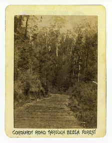 Marysville & District Historical Society
Photograph (Item) - Black and white photograph, Corduroy Road Through Beech Forest, c1900
An early black and white photograph of a corduroy road running through the forest near Marysville in Victoria.An early black and white photograph of a corduroy road running through the forest near Marysville in Victoria. A corduroy road (or log road) is a type of road or timber trackway made by placing logs, perpendicular to the direction of the road over a low or swampy area. The result is an improvement over impassable mud or dirt roads, yet rough in the best of conditions and a hazard to horses due to shifting loose logs.ARMSTRONG COLLECTION 42 STATION STREET/ SANDRINGHAM 3191/ TEL. (03) 9521 5442/ IAN M.L. ARMSTRONG OAMcorduroy road, marysville, victoria, beech forest -
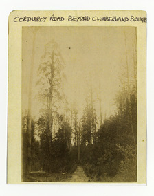 Marysville & District Historical Society
Photograph (Item) - Black and white photograph, Corduroy Road Beyond Cumberland Bridge, c1900
An early black and white photograph of a corduroy road running through the forest near Marysville in Victoria.An early black and white photograph of a corduroy road running through the forest near Marysville in Victoria. A corduroy road (or log road) is a type of road or timber trackway made by placing logs, perpendicular to the direction of the road over a low or swampy area. The result is an improvement over impassable mud or dirt roads, yet rough in the best of conditions and a hazard to horses due to shifting loose logs.ARMSTRONG COLLECTION 42 STATION STREET/ SANDRINGHAM 3191/ TEL. (03) 9521 5442/ IAN M.L. ARMSTRONG OAMcorduroy road, marysville, victoria -
Ringwood and District Historical Society
Pamphlet, Vic Roads, Eastern Freeway: Doncaster Road to Springvale Road extension, and Scoresby Transport Corridor. Pamphlets. 1993-6, 1993-1994 & 1996
Eastern Freeway: Doncaster Road to Springvale Road extension - 2 pamphlets;; Scoresby Transport Corridor: 1 pamphlet. -
 Eltham District Historical Society Inc
Photograph, Wattletree Road Bridge, Eltham, c. August 1977, 1977
Traffic island at intersection is lined with white-painted bluestone edging which originally was part of the Eltham lock-up situated at 728 Main Road. The bluestone has since been re-used (from late 1980s) at the rear of 728 Main Road to form the garden bed in car park. Colour photographeltham, infrastructure, main road, shire of eltham infrastructure, wattletree road bridge, bridge -
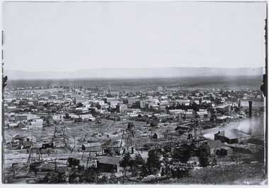 Stawell Historical Society Inc
Photograph, View of Stawell from Big Hill April 1874 showing mines centered on north end of Main Street -- 2 Photos
From left Shire Hall Pleasant Creek in distance, Mathers & Franklin, Stawell Coach Factory, Coffee Palace, Christ Church of England Church Hill, Mechanics Institute, Temperance Hotel, Matherson Cross Reef Hotel.Black and White Holtermann photograph of Stawell from Big Hill with mining in foreground. 1874 Site of fire in Main and Street Patrick Street 22 April 1874 visible in centre of photograph.mining, panorama, streetscape -
Whitehorse Historical Society Inc.
Pamphlet, Main Street Mitcham, 2000
History of Main Street Mitcham by Keith Hancock featured in Mitcham Primary School Newsletter No. 2, Dec 2000.History of Main Street Mitcham by Keith Hancock featured in Mitcham Primary School Newsletter No. 2, Dec 2000. Also contributions from Jean holly, Ian McFarlane and Frances RothnieHistory of Main Street Mitcham by Keith Hancock featured in Mitcham Primary School Newsletter No. 2, Dec 2000.mitcham road mitcham, city of whitehorse, mitcham primary school, no. 2904, whitehorse road mitcham, britannia street mitcham, memorial hall mitcham -
 Eltham District Historical Society Inc
Album - Photograph, J.A. McDonald, Eltham-Greensborough Road, July 1956
Diamond Creek Bridge (Bridge Street Bridge) General view looking to Main Road View looking east up Bridge Street to Main Road prior to widening. The Eltham Obelisk is located at the top of the hill on the left but was relocated to the Eltham RSL front garden as a reesult of road widening works and improvements to the intersection. On the immediate right is the present-day Eltham Rugby Union ovalRecord of various Shire of Eltham infrastructure works undertaken during the period of 1952-1962 involving bridge and road reconstruction projects, sometimes with Eltham Shire Council Project Reference numbers quoted. It was during this period that a number of significant improvements were made to roads and new bridges constructed within the shire that remain in place as of present day (2022). In many situations, the photos provide a tangible visible record of infrastructure that existed throughout the early days of the Shire. The album was put together by or under the direction of the Shire Engineer, J.A. McDonald.infrastructure, road construction, shire of eltham, bridge construction, bridge street bridge, eltham, eltham-greensborough road, 1956-07 -
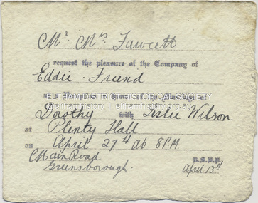 Eltham District Historical Society Inc
Document - Invitation, Invitation to the wedding reception of Dorothy Fawcett and Leslie Wilson, Plenty Hall, Main Street, Greensborough, April 27, 1940
Invition to Richard Edward Fielding and a friend to attend the wedding reception for Dorothy Fawcett and Leslie Wislon at Plenty Hall, Greensborough on April 27, 1940 Mr - Mrs Fawcett request the pleasure of the Company of Eddie - Friend at a Reception in honour of the Marriage of Dorothy with Leslie Wilson at Plenty Hall on April 27th at 8 P.M Main Road, Greensborough. R.S.V.P. April 13thdorothy may fawcett, greensborough, leslie anzac wilson, main street, plenty hall, reception, richard edward fielding, tom fielding collection, wedding invitation -
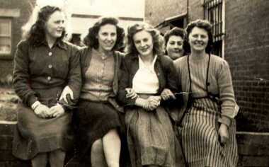 Greensborough Historical Society
Photograph - Digital Image, Latoof Main Street Greensborough, 1950c
Workers at Latoof Clothing Factory, Main Street, Greensborough, which later moved to Lambourn Road Watsonia. (Left to right) Unknown English Woman, Peggy Barnett, Audrey Blackbourn, [Back-Lady from Hurstbridge], Billy Hollibone from Wattle Glen. Photographs from the collection of Peter Blackbourn, a descendant of the Chapman Stock family. Annotations to photos by Peter Blackbourn.Digital copy of black and white photograph.peter blackbourn, audrey blackbourn, peggy barnett, latoof and callil, billy hollibone -
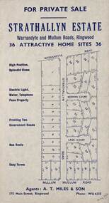 Ringwood and District Historical Society
Flyer, Land Sale Advertisement - Strathallyn Estate, Ringwood, Victoria - circa 1950
Advertisement for private sale of 36 home sites in the Warrandyte Road and Mullum Mullum Road area of Ringwood, with map showing layout of subdivision and summary of local features and services. Handwritten notation indicates May, 1950.Subdivision includes Warrandyte Road, Strathallyn Road, Norman Court, Lade Court, and Mullum Mullum Road. Agents: A.T. Miles & Son, 175 Main Street, Ringwood, Phone WU6215. -
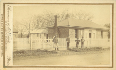 Bacchus Marsh & District Historical Society
Photograph, Police Barracks Main Street Bacchus Marsh 1883
The Bacchus Marsh Police Barracks shown in this image were located in Main Street on the site of the present day Police Station. The Barracks were constructed around 1857 or 1858. Prior to this the Police were stationed in the Police Paddocks at Maddingley in the area where Maddingley Park is now located. This building was in use by the Police until 1930 when it was replaced by a new building. This later building was in use until the early 2000s but was demolished in 2003 and replaced by a larger Police building.Small sepia unframed photograph on card with gold border framing photograph. Housed in the album, 'Photographs of Bacchus Marsh and District in 1883 by Stevenson and McNicoll'. The image shows the Bacchus Marsh Police Police Barracks and stables in 1883. Two uniformed male police officers wearing helmets can be seen standing on the footpath in front of the building. Next to them on their left stand two boys, one holding a document, possibly a newspaper.. The Barracks is a sandstone building with a chimney on one side; it appears to have a slate roof. Two buildings can be seen behind the main building. A white picket fence with a double gate runs along the front of the complex.On the front: Stevenson & McNicoll. Photo. 108 Elizabeth St. Melbourne. COPIES CAN BE OBTAINED AT ANY TIME. On the back: LIGHT & TRUTH inscribed on a banner surmounted by a representation of the rising sun. Copies of this Portrait can be had at any time by sending the Name and Post Office Money Order or Stamps for the amount of order to STEVENSON & McNICOLL LATE BENSON & STEVENSON, Photographers. 108 Elizabeth Street, MELBOURNE. stevenson and mcnicoll 1883 photographs of bacchus marsh and district, bacchus marsh police station, police stations, police