Showing 6698 items
matching river
-
 Malmsbury Historical Society
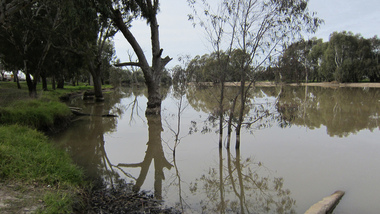
Photograph (Item), Landscape Malmsbury, Malmsbury ca2003
Buildings - Coliban River People - "Tynan, Alexandra (Photographer)" -
 Malmsbury Historical Society
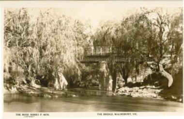
Postcard (Item), "Postcard Bridge At Malmsbury, Rose Series P4676", Malmsbury c1927
Associated with - Rose Series P4676 Buildings - Coliban River -
 Malmsbury Historical Society
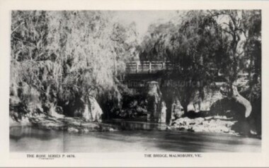
Postcard (Item), "Postcard Bridge At Malmsbury, Rose Series P4676", Malmsbury c1930
Associated with - Rose Series P4676 Buildings - Coliban River -
 Mont De Lancey
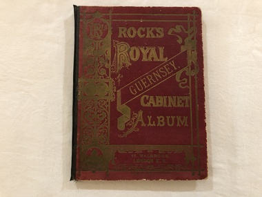
Book, Rock's Royal Guernsey. Cabinet Album
Mrs Liddy, 59 River Street, Maidstone, VictoriaA maroon covered album containing Postcard scenes of Guernsey. Printed in Germany. The title is embossed in gold lettering and pattern on the front cover with a black spine binding.albums, books, photographs, guernsey -
 Eltham District Historical Society Inc
Photograph, Fay Bridge, Ruins of the old Warrandyte Battery, 7 November 2016
Remains of the timber foundation of the State Battery, built here in 1897 can be seen on the banks of the Yarra River just east of the Warrandyte Bridge on the Warrandyte side of the river. The Battery was driven by waterwheel and was used to crush ore from the Warrandyte Goldfields.fay bridge collection, 2016-11-07, warrandyte battery, ruins -
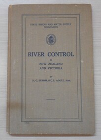 Bendigo Historical Society Inc.
Book - River Control in New Zealand and Victoria, 1941
This book was commissioned by the State Rivers and Water Supply Commission on the recommendation of Frank E. Old, Minister of Water Supply to meet the need for a comprehensive and progressive policy of river improvement. This book was presented to Milton King, the father of the donor Neville King.Khaki coloured hard cover book. 131 pp. Black and white illustrations and diagrams. Author H.G.Strom, BCE, AMIE. Australia. Neville King CollectionM R King 29/08/41 written in pencil inside the front cover.water supply, rivers, h g strom -
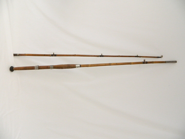 Kiewa Valley Historical Society
Rod Fishing, circa early 1900's
This bamboo fishing rod was used in the mid to late 1900's and demonstrates that local production of recreational fishing poles was at a high level and their demand was high. Imported recreational sporting goods from either the United Kingdom, the United States of America or Asia countries was due to the larger lead up times from these suppliers and the greater import costs from slower ocean supply ships. It was only after World War II that the trade influx from other countries has supplied cheaper goods. This recreational fishing pole is highly significant to the Kiewa Valley as it demonstrates that recreational fishing has been evolved from the need to supply a balanced diet by the early pioneer families of fish from the major Kiewa rivers. The ability of the Kiewa Valley rivers to provide a good fishing environment (high protein diet) for both early indigenous families and early pioneers was the important food source that provided for a balanced diet and the higher level of nutritious development of both body and mind. This two piece wooden fishing Rod is made from bamboo shafts or poles, one length thicker than the other. The smaller diameter shaft is the top end and fits into the longer thicker shaft at a stainless steel tube end.The smaller shaft has a stainless steel reinforcement ring where both shafts fit together. At the bottom end of the thick shaft is a black rubber "stopper" or "foot". There are two stainless steel rings, each with a reel holding "bulge" which allows for the the reel's "prongs" to be secured. The top ring has a greater diameter allowing it to move up and down the shaft/pole to secure the top "prong" firmly onto the shaft/pole.recreation, river, rod, fishing, industry, fish -
 Federation University Historical Collection
Photograph, Gold Dredge
Black and white mounted photograph of a dedge floating on a body of water which has a creek flowing into it, and rolling hills in the background. The buildings associated with a mine or factory are shown on the top left hand side. Signed "Martin ?ish Victoria St" verso "R.H. Brooke, "Callantina Villa", Glenferrie Rd Sthdredge, dredging, mining, river, callantina villa, gold mining -
 Ballarat Heritage Services
digital photographs, Lisa Gervasoni, pre olympic pool, c2010-2017
swimming pool, sport, swimming, pre olympic, dimboola, river -
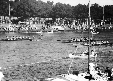 Power House Rowing Club
Black and white photograph, PHRC Maiden VIII Henley win, 1935, 1935
Digital scan of black and white photograph. Names not recorded.rowing, rowers, river, riverbank, spectators, boats -
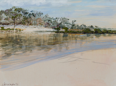 Bayside Gallery - Bayside City Council Art & Heritage Collection
Painting - oil on canvas, Judith Wharington, Echo of Orpheus, 1981
judith wharington, orpheus, echo, river, landscape, greek mythology -
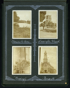 Magnet Galleries Melbourne Inc
Views of England / boxing
Four photos on a page from an albumww1, world war 1, boxing, church, england, river -
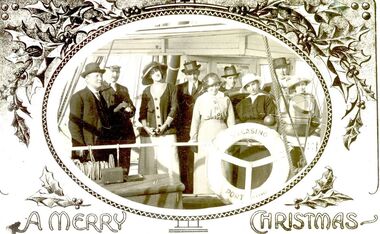 Port Fairy Historical Society Museum and Archives
Card - Photograph
Passengers on board the SS CasinoGreeting card depicting passengers on Board the SS CasinoA Merry Christmasship, boat, sea, river, ss casino, passengers -
 Port Fairy Historical Society Museum and Archives
Photograph
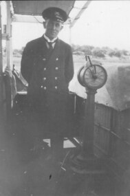
Captain John H Dowling aboard the S.S.Coramba. He was the Captain of the ship when it was lost in a storm off Phillip Island on the 29th November 1934. All hands were lost Black & white photograph of captain John Dowling standing alongside the engine order telegraphship, boat, sea, river, coramba, seaman -
 Port Fairy Historical Society Museum and Archives
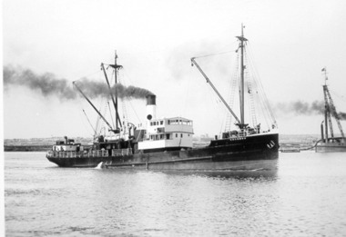
Photograph, T.S.S.Coramba
Photograph of T.S.S.Coramba owned by Belfast and Koroit Steam Navigation CompanyPhotographship, port fairy, boat, sea, river, belfast and koroit steam navigation company -
 Port Fairy Historical Society Museum and Archives
Photograph, HMAS Yarra
H.M.A.S. Yarra on goodwill visit to Port Fairy 1921A rare image of a war ship anchored at the Moyne river wharfBlack& White photographship, boat, sea, river, hmas yarra, moyne river -
 Port Fairy Historical Society Museum and Archives
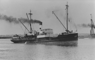
Photograph
T.S,S.Coramba owned by the Belfast and Koroit Steam Navigation Company in the 1930'sPhotographship, boat, sea, river, port fairy, belfast and koroit steam navigation company -
Port Fairy Historical Society Museum and Archives
Photograph
martin's Point from the air very early (research ongoing)black and white aerial photograph of Martin's Point Port Fairyaerial, martins point, dredge, boat, river, land -
 Ballarat Heritage Services
Photograph - digital photographs, Lisa Gervasoni, Horsham pre olympic pool, c2010-2017
Photograph of Horsham Pre-Olympic Swimming holeswimming pool, sport, swimming, pre olympic, horsham, river -
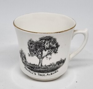 Wodonga & District Historical Society Inc
Souvenir - Cup Hovell's Tree, Albury
This souvenir represents the Hovell Tree, a local historic landmark in Albury, NSW. This item is from a collection donated by descendants of John Francis Turner of Wodonga. The Hovell Tree commemorates the exploration and naming of the Hume River (now the Murray) by Hume and Hovell`s expedition of 1824. In 1824, Governor Brisbane asked Hume to join forces with an English sea captain, William Hovell, to go from Lake George to the Spencer Gulf in South Australia. The Hovell Tree, marked by William Hovell on November 17, 1824 was flanked by another tree marked by Hamilton Hume which was destroyed by fire in the 1840's. The river gum was marked by William Hovell when discovering river. Hume and Hovell travelled from the Yass area and after crossing the Murray River where Lake Hume now is, they crossed the Mitta Mitta River and proceeded to Corio Bay, Westernport.This item is representative of souvenirs produced to represent key buildings and historic landmarks in the Albury-Wodonga district.A white cup with gilt trim around the lip. It bears an image of the Hovell Tree in Albury, NSWBeneath image: "HOVELL'S TREE, ALBURY."albury souvenirs, hovell tree, hume and hovell, australian exploration -
![Photograph - Digital image, Pioneer Children's Cemetery [from above], 1985_](/media/collectors/4f729f5697f83e03086015b8/items/54bb56202162f10ca8d79013/item-media/54bb56452162f10ca8d79127/item-fit-380x285.jpg) Greensborough Historical Society
Greensborough Historical SocietyPhotograph - Digital image, Pioneer Children's Cemetery [from above], 1985_
The unmarked graves of the children of two Greensborough pioneer families lie in a private cemetery on the Plenty River. Burials occurred between 1848 and 1860. This photograph is taken from above the cemetery site looking towards the Plenty River with the Maroondah Aqueduct in the background.An important historical site in Greensborough.Digital copy of colour photograph.pioneer childrens cemetery, plenty river, maroondah aqueduct, partington, whatmough -
![The Bend of the Yarra at Studley Park / [by] Nicholas Caire, circa 1876](/media/collectors/550653872162f11fb04854aa/items/5783120ed0cdd1176c47d8c8/item-media/57831278d0cdd1176c4805d6/item-fit-380x285.jpg) Kew Historical Society Inc
Kew Historical Society IncPhotograph, Anglo-Australasian Photographic Company, The Bend of the Yarra at Studley Park, c. 1876
Nicholas Caire was born on Guernsey in the Channel Islands in 1837. He arrived in Adelaide with his parents in about 1860. In 1867, following photographic journeys in Gippsland, he opened a studio in Adelaide. From 1870 to 1876 he lived and worked in Talbot in Central Victoria. In 1876 he purchased T. F. Chuck's studios in the Royal Arcade Melbourne. In 1885, following the introduction of dry plate photography, he began a series of landscape series, which were commercially successful. As a photographer, he travelled extensively through Victoria, photographing places few of his contemporaries had previously seen. He died in 1918. Reference: Jack Cato, 'Caire, Nicholas John (1837–1918)', Australian Dictionary of Biography.An original, rare photograph from the series 'Views of Victoria: General Series' by the photographer, Nicholas Caire (1837-1918). The series of 60 photographs that comprise the series was issued c. 1876 and reinforced a neo-Romantic view of the Australian landscape to which a growing nationalist movement would respond. Nicholas Caire was active as a photographer in Australia from 1858 until his death in 1918. His vision of the Australian bush and pioneer life had a counterpart in the works of Henry Lawson and other nationalist poets, authors and painters.‘The Bend of the Yarra at Studley Park’ : Views of Victoria (General Series) No.49 : Albumen silver photograph | Photo on card with Title and Description on reverse | Mounted 24 x 30 cm; Photo 12 x 17 cm.On Reverse: The subject of the present illustration is taken from near the Kew Road, on the Park-hill side of the Yarra. The curve of the River at this and other parts of the Park represents a gigantic letter S. It is a remarkable fact that the hilly side of the River is covered with a mass of foliage of various descriptions, from the stately gum tree to the stunted wattle, whilst the opposite side of flat country has scarcely a shrub to be seen any where.’nicholas caire (1837-1918), studley park, yarra river, kew, landscape photography - victoria -
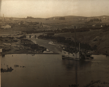
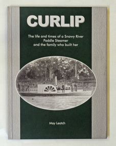 Orbost & District Historical Society
book, Curlip, November 2008
This book was written at the same time as the replica of the PS Curlip was being built in Orbost. The great grandson of Samuel Richardson is Gil Richardson who lives in Bete Bolong just outside Orbost. Gil and Heather Richards presented the author, May Leatch with a box of old diaries written by Sam Richardson and Sam's sons, Alan and Frank. Using these as the basis of the story, May wrote the full story of the Curlip and the Richardson family.This book about a local icon and a local family was written in Orbost by a local historian.A green and grey covered book titled, CURLIP The life and times of a Snowy River Paddle Steamer and the family who built her. On the front cover is a black and white photograph of the PS Curlip taken shortly after its launch in 1890. On the back cover is a black and white photograph of phragmites on the Snowy River floodplain. The book traces the history of the Richardson family from Godalming, Surrey, England to Orbost, East Gippsland, Victoria in Australia. It contains b/w photographs, diary extracts and newspaper extracts. The book was written by May Leatch.p.s.curlip paddle-steamers orbost richardson-family richardson-samuel -
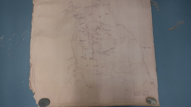 Kiewa Valley Historical Society
Map - Bogong High Plains
Bogong high Plains showing mountains, places, roads and riversHistorical changes of infrastructure on the Bogong High PlainsBogong High Plains, hand written and 'copied with considerable simplification from F.C.V. (Falls Creek V.?) 'Feathetop' L 'Tawonga'. Paper is yellowed, writing is brown.bogong high plains map -
 Greensborough Historical Society
Slide - Photograph, John Ramsdale, Plenty Gorge: Slide 106, 1990s
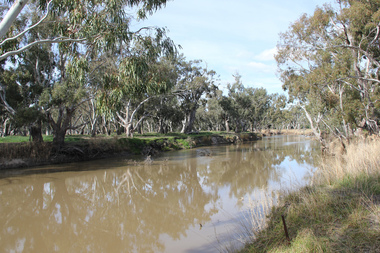
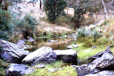
Photograph shows a rocky area near river in Plenty Gorge.Part of the John Ramsdale collection of slides and audio visual material.Colour photograph scanned from slide.No maker's marks. No caption on slide.plenty river, plenty gorge -
 Greensborough Historical Society
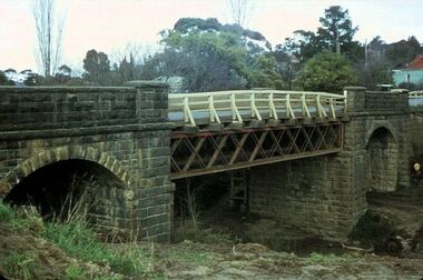
Photograph - Photograph - Digital Image, Bluestone bridge Greensborough 1960s, 1960s
A photograph of the bluestone bridge over the Plenty River at Greensborough 1960s.Digital copy of colour photograph. Second photo is cropped copy.bluestone bridge greensborough, plenty river greensborough, main street greensborough -
 Greensborough Historical Society
Photograph - Digital Image, Dual pipes: Aqueduct Greensborough, 2000c
Photograph of section of the Maroondah aqueduct over the Plenty River at Greensborough.Digital copy of colour photograph.maroondah aqueduct, aqueduct greensborough -
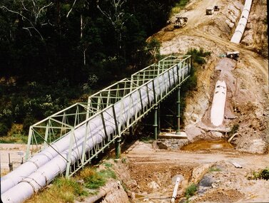 Greensborough Historical Society
Photograph - Digital image, New pipeline replacing Watts Reservoir aqueduct, 1977_
Photograph of new aqueduct pipe near Plenty River Greensborough.Digital copy of colour photograph.aqueduct, maroondah aqueduct, plenty river -
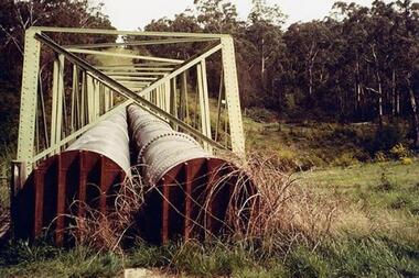
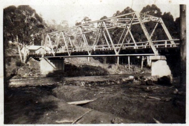 Greensborough Historical Society
Photograph - Digital Image, Pipes over Plenty, construction of original bridge for Watts Reservoir aqueduct, 1950-1970
Photograph of the Maroondah aqueduct bridge over the Plenty River in Greensborough.Digital copy of black and white photograph.maroondah aqueduct, aqueduct, plenty river -
 Greensborough Historical Society
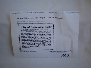
Newspaper clipping, City of swimming pools, 08/03/1937
A report on the opening of the Greensborough swimming pool in the Plenty River 1937.This pool on the Plenty River still exists today.Article downloaded from Trove (National Library of Australia).greensborough, swimming pools, plenty river, heidelberg city council