Showing 178917 items
matching streets
-
 Port Melbourne Historical & Preservation Society
Photograph - 51 & 52 Evans Street, Port Melbourne, Meredith Turnbull, Dec 1996
Meredith Turnbull photographed this series in 1996 to record the rapidly changing streetscape, which had already had a number of old houses replaced by concrete two-storey structures under the State government's urban consolidation policyFrom a series of 70 colour photos recording all buildings in Evans Street from Graham Street overpass to Ingles Street, as photographed from the railway reservation, by Meredith Turnbull in December 1996 - number 51, 52House numbers noted on backbuilt environment - domestic, meredith turnbull -
Port Melbourne Historical & Preservation Society
Photograph - 59 & 60 Evans Street, Port Melbourne, Meredith Turnbull, Dec 1996
Meredith Turnbull photographed this series in 1996 to record the rapidly changing streetscape, which had already had a number of old houses replaced by concrete two-storey structures under the State government's urban consolidation policyFrom a series of 70 colour photos recording all buildings in Evans Street from Graham Street overpass to Ingles Street, as photographed from the railway reservation, by Meredith Turnbull in December 1996 - number 59, 60House numbers noted on backbuilt environment - domestic, meredith turnbull -
Port Melbourne Historical & Preservation Society
Photograph - 69 & 71 Evans Street, Port Melbourne, Meredith Turnbull, Dec 1996
Meredith Turnbull photographed this series in 1996 to record the rapidly changing streetscape, which had already had a number of old houses replaced by concrete two-storey structures under the State government's urban consolidation policyFrom a series of 70 colour photos recording all buildings in Evans Street from Graham Street overpass to Ingles Street, as photographed from the railway reservation, by Meredith Turnbull in December 1996 - - number 69, 71House numbers noted on backbuilt environment - domestic, meredith turnbull -
Port Melbourne Historical & Preservation Society
Photograph - 82 & 83 Evans Street, Port Melbourne, Meredith Turnbull, Dec 1996
Meredith Turnbull photographed this series in 1996 to record the rapidly changing streetscape, which had already had a number of old houses replaced by concrete two-storey structures under the State government's urban consolidation policyFrom a series of 70 colour photos recording all buildings in Evans Street from Graham Street overpass to Ingles Street, as photographed from the railway reservation, by Meredith Turnbull in December 1996 - number 82, 83House numbers noted on backbuilt environment - domestic, meredith turnbull -
Port Melbourne Historical & Preservation Society
Photograph - 92 & 94 Evans Street, Port Melbourne, Meredith Turnbull, Dec 1996
Meredith Turnbull photographed this series in 1996 to record the rapidly changing streetscape, which had already had a number of old houses replaced by concrete two-storey structures under the State government's urban consolidation policyFrom a series of 70 colour photos recording all buildings in Evans Street from Graham Street overpass to Ingles Street, as photographed from the railway reservation, by Meredith Turnbull in December 1996 - number 92, 94House numbers noted on backbuilt environment - domestic, meredith turnbull -
Port Melbourne Historical & Preservation Society
Photograph - 114 & 115 Evans Street, Port Melbourne, Meredith Turnbull, Dec 1996
Meredith Turnbull photographed this series in 1996 to record the rapidly changing streetscape, which had already had a number of old houses replaced by concrete two-storey structures under the State government's urban consolidation policyFrom a series of 70 colour photos recording all buildings in Evans Street from Graham Street overpass to Ingles Street, as photographed from the railway reservation, by Meredith Turnbull in December 1996 - number 114, 115House numbers noted on backbuilt environment - domestic, meredith turnbull -
Port Melbourne Historical & Preservation Society
Photograph - 123 & 124 Evans Street, Port Melbourne, Meredith Turnbull, Dec 1996
Meredith Turnbull photographed this series in 1996 to record the rapidly changing streetscape, which had already had a number of old houses replaced by concrete two-storey structures under the State government's urban consolidation policyFrom a series of 70 colour photos recording all buildings in Evans Street from Graham Street overpass to Ingles Street, as photographed from the railway reservation, by Meredith Turnbull in December 1996 - number 123, 124House numbers noted on backbuilt environment - domestic, meredith turnbull -
Port Melbourne Historical & Preservation Society
Photograph - 157, 159 & 160 Evans Street, Port Melbourne, Meredith Turnbull, Dec 1996
Meredith Turnbull photographed this series in 1996 to record the rapidly changing streetscape, which had already had a number of old houses replaced by concrete two-storey structures under the State government's urban consolidation policyFrom a series of 70 colour photos recording all buildings in Evans Street from Graham Street overpass to Ingles Street, as photographed from the railway reservation, by Meredith Turnbull in December 1996 - 157, 159, 160House numbers noted on backbuilt environment - domestic, meredith turnbull -
Port Melbourne Historical & Preservation Society
Photograph - 161 & 162 Evans Street, Port Melbourne, Meredith Turnbull, Dec 1996
Meredith Turnbull photographed this series in 1996 to record the rapidly changing streetscape, which had already had a number of old houses replaced by concrete two-storey structures under the State government's urban consolidation policyFrom a series of 70 colour photos recording all buildings in Evans Street from Graham Street overpass to Ingles Street, as photographed from the railway reservation, by Meredith Turnbull in December 1996 - number 161, 162House numbers noted on backbuilt environment - domestic, meredith turnbull -
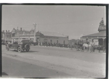 Sunbury Family History and Heritage Society Inc.
Photograph, c
A black and white photograph of a main street with buildings in a town. There is a 1920s motor car being driven along the street with a stationary horse and cart on the opposite side. Members of a pipe band are waiting further up the street to perform. towns -
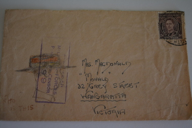 Wangaratta RSL Sub Branch
Envelope Art
One of series of illustrated envelopes, without letter, sketched by soldier/s during the second world war and sent to Mrs McDonald of Grey Street WangarattaVictoria's 2/24th Infantry Battalion was raised in Wangaratta in July 1940. They were welcomed with open arms by the local community as they rapidly built up their numbers. The people of Wangaratta adopted the Battalion and they became known as "Wangaratta's Own" because of the time the battalion spent in the town during its formative period prior to deployment overseas. Many of the soldiers maintained life long friendships with the people of Wangaratta. Even though the Battation was disbanded in 1946 members and their families return each year, in November, for a commemorative service at the 2/24th Battalion Memorial Wall at the Wangaratta Cemetery.Cream paper envelope with drawing of side profile of male wearing hat.Top right - postage stamp Left side - AIF Censor stamp Centre - Mrs M MacDonald "Monald" 32 Grey Street Wangaratta Victoria Australia Bottom left - "Who is this?" Rear - Red Cross ww2, envelope art -
Port Melbourne Historical & Preservation Society
Document - Handbill, Port Melbourne refuse collection schedule, 1941
Found at Hazel Wilson's house (78 Princes Street) when things were being removed after she went into a nursing homeDetails in words and on a street map of refuse collection days for the City of Port Melbourne, 1941: 01. Handbill with map of Port Melbourne in 1941, sub-dividing into days for refuse collection. Includes specific instructions for residents 02 Accompanying retyped version of the instructions shown on the maplocal government - city of port melbourne, utilities, domestic life, built environment, hazel trembath wilson -
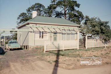 Eltham District Historical Society Inc
Photograph, Russell Yeoman, 66 Susan Street, Eltham, 1965c
... streets ...Farmhouse built in the late 1800s by the Crozier Family. Subsequently owned by the Hill Family. Purchased in the early 1960s and by 1965 the property was owned by the Shire of Eltham. Employees of the Shire lived in the house. In 2006 the Shire of Nillumbik demolished the house which had been subject to extensive vandalism. In accordance with heritage advicde and a permit condition a sign was placed on the site outlining the history of the building. This was installed and remained in place till about 2016 when it was removed. The lands adjoins Alistair Knox Park. By 2010 the Eltham Skate Park was developed. In 2022 a major renovation and extension took place. Sources: EDHS Newsletter No 171 November 2006 and Google Street View. Digital file only; created from original colour positive slide transparencyeltham, streets, houses, susan street, alistair knox park, eltham skate park, russell yeoman collection, fc holden sedan -
Federation University Historical Collection
Photograph, Standpipe in Ballarat, c1967
Black and white photograph of a standpipe (Water outlet) on the corner of Sturt and Errard Street, in the centre strip known as the Sturt Street Gardens.sturt street gardens, standpipe, water outlet -
Glenelg Shire Council Cultural Collection
Print - Contact Print - Percy Street Portland, 1960-1979
Black and white contact print from glass plate negative. Image of Percy Street looking north from Julia Street. -
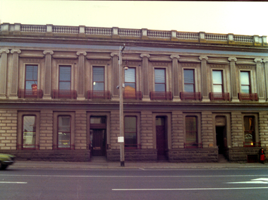 Federation University Historical Collection
Photograph - Colour, Cuthberts Solicitors, Mair Street, Ballarat
Double storey building in the corner of Mair Street and Lydiard Street North, Ballarat. It was used by Cuthberts Solicitors in 2005 (later Harwoods).cuthbert solicitors, mair street, lydiard street north, legal -
 Federation University Historical Collection
Photograph - Photograph - Black and White, Solomon and Bardwell, Ballarat Gas Office
Photograph of a brick building with arch windows. It is the Ballarat Gas Office located on the south west corner of Grenville Street and Sturt Street.ballarat gasworks, ballarat gas office, solomon and bardwell -
 Bendigo Historical Society Inc.
Photograph - CASTLEMAINE GAS COMPANY COLLECTION: PHOTO SEC BUILDING
SEC Building in Williamson Street. A variety of vehicles angle parked along Williamson Street, bas of the communications tower can be seen.bendigo, streetscape, williamson street -
 Bendigo Historical Society Inc.
Photograph - EDITH LUNN COLLECTION: FREDERICK AND BASSEMIR'S OLD BAKERY, CORNER OF EDWARDS & WILLS STREETS
Frederick & Bassemir's Old Bakery building on the corner of Edwards & Wills Streets photo taken form Edwards & Garsed Streets cornerEdith Lunn -
Port Melbourne Historical & Preservation Society
Photograph - Council workers, Kenny Hall and Robin Donchi Snr, Port Melbourne, 1980s
Probably taken in the 1980sKenny Hall and Robin Donchi Senior near Liardet and Pickles Streets digging test holes for a tunnel under Cruickshank Street.engineering - roads streets lanes and footpaths, robin donchi snr, ken hall -
Port Melbourne Historical & Preservation Society
Document, Chain of title for 351 Princes Street, Port Melbourne 1859-2008, 1913 - 1939
Held by Titles Office from 1859 to about 2004. Peter Parrington obtained them after converting title to more common Torrens.Chain of title for 351 Princes Street, Port Melbourne 1859-2008 Conveyance of 351 Princes Street 09/09/1913built environment - domestic, families, dennis ryan, bridget ryan, ryan, stephen, clark street, princes street, john harbison, margaret ryan, b & j howletti, j anderson, n clelland, p j (peter) parrington, s l (sue) parrington -
Port Melbourne Historical & Preservation Society
Document - Specification, Tramway, Normanby Road, Ingles Street to Boundary Street, Port Melbourne, 14 Mar 1893
Written specification for works attached to plan of tramway in Normanby Road from Ingles Street to Boundary Street (Reg 66.1), 1893.A.V. Heath (Town Surveyor) J.J. Bartlett (Mayor)engineering - roads streets lanes and footpaths, transport - tramways, town planning, town clerks, mayors, arthur victor heath, james john bartlett -
Port Melbourne Historical & Preservation Society
Plan - Williamstown Road, Derham Street to Raglan Street, Port Melbourne, 14 Mar 1893
Plan of Williamstown road from Derham street to Raglan street. (67.1), together with written specification of works attached. (67.2), 1893.A.V. Heath (Town Surveyor). J.J. Bartlett (Mayor).engineering - roads streets lanes and footpaths, arthur victor heath, town clerks, james john bartlett, mayors -
 Port Melbourne Historical & Preservation Society
Photograph - Bay Street, west side near Raglan Street, Port Melbourne, c. 1980
B&W photo of Bay Street, West side near Raglan Street looking towards Faram Bros c 1980bay street, built environment - commercial, business and traders - hardware, tony cannatelli, business and traders, faram brothers hardware -
 Port Melbourne Historical & Preservation Society
Photograph - Raglan Street Housing Commission Flats, corner Raglan and Crockford Streets, BP petrol station, 1968
B&W photo of Raglan Street Housing Commission Flats, corner Raglan and Crockford Streets, BP petrol station c1968built environment - domestic, built environment - public housing, built environment - commercial, antonio cannatelli, raglan street housing commission of victoria flats -
 Port Melbourne Historical & Preservation Society
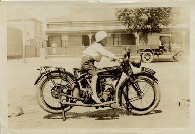
Photograph - Boy on motorbike in Bridge Street near corner of McCormack Street, Port Melbourne, 1920s
Sepia photo of young boy on Rudge-Whitworth motorbike in Bridge Street near corner of McCormack Street. Delivery van in background.transport - motor vehicles, rudge-whitworth motorbike -
Port Melbourne Historical & Preservation Society
Photograph - Aerial view of Port Melbourne, 1931
Section of aerial photograph of Port Melbourne c1931 (refer item 574), covering Beach to Spring Street and Lagoon to Lyons Streetsandridge lagoon, built environment -
Port Melbourne Historical & Preservation Society
Photograph - Beach Street from Princes Street, Sandridge, 1872
Item 13.01 from set of originals belonging to Town Clerk 1920-1959, was restored digitally and this print made by Appro Images of Albert Park in February 1999.Restored copy of item 13.01: Beach Street from Princes Street c1872 showing the London, Freemasons Tavern and Sugar Millbuilt environment, hotels, charles f g urquhart, london family hotel, freemasons tavern, beach street -
Port Melbourne Historical & Preservation Society
Plan - Ingles Street, Port Melbourne, 12 Jan 1866
Plans for Ingles Street showing both ground plan and longitudinal and traverse sections at Station Place, Heath, Nott and Bay Streets.Signed by surveyor Chas. Clay and James Bibby plus Thomas (Reek) Warren as witness to latter sig. Also a no: 355/H1 added later.engineering - roads streets lanes and footpaths, charles clay, thomas (reek) warren, james bibby -
 Bendigo Historical Society Inc.
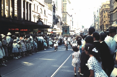
Slide - PROCESSION, 1961
Slide. ST.PATRICK'S PROCESSION, MELBOURNE 1961. Streets lined with onlookers. Boys marching, Newport Sacred heart. Melbourne street processionslide, bendigo, procession