Showing 4549 items matching "historical map"
-
 Stawell Historical Society Inc
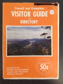
Book, Forests Commission, Stawell & Grampians Visitor Guide & Directory 1976, 1976
Tourist Brochure for Stawell and Grampians Region. Included is a Map Titled Grampain's Wonderland Forest ParkOrange Paper cover with white Print Middle of cover is a colour Picture of the Grampians.Stawell and Grampians VISITOR GUIDE and Directory. On teh Bottom right. Issued by the Stawell and Grampians Tourist Promotion Advisory Council . On the Left in two White circles "Recommended 50c Price."stawell tourism -
 Stawell Historical Society Inc
Book, Allan Nelson & Leslie & Carl Loeliger, Lubeck School Centenary 1983, 1983
History of the Lubeck School and "Back to Lubeck" Weekend Sept 11-12 2004. Lubeck School Centenary book compiled August 20th 1983. 687.1 Back To Lubeck Weekend Sept. 11 & 12 2004. 681.2 A Poat Script to Lubeck School Centenary Dec. 17.1989White booklet with map on cover in Green Ink, Title in Brown Printin Brown Print: Lubeck School Cnetenary 1983stawell education -
 Stawell Historical Society Inc
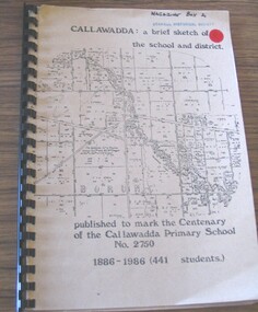
Book, John C Read, Callawadda : a brief sketch of the school and district - School Centenary 1986, 1986
Callawadda: a brief sketch of the school and districtFawn cover with map of Borung.Callawadda: a brief sketch of the school and district published to mark the Centenary of the Callawadda Primary School No. 2750 1886-1986 (441 Students)stawell education -
 Stawell Historical Society Inc
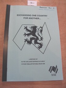
Book, Marie and Graham Moore, Exchanging One Country for Another - A History of David and Janet Bowman & Family in Port Phillip/Victoria from 1840, 1988
Published for a reunion of David and Janet Bowman's decendentsPale Blue card cover with black ink title below which is a stylised map of Australia and The Welsh lion Bi-Centential Logo in bottom RightExchanging One Country for Another. A History of David and Janet Bowman & Family in Port Phillip/Victoria from 1840. Australia 1788-1988stawell immigration -
 Stawell Historical Society Inc
Photograph - Mining Scene, Close up
See Holtman Panarama photo 2Sepia Print Mining Scene, map of Victoria marking Stawellmining, stawell -
Stawell Historical Society Inc
Photograph, Re-Accreditation Meeting 2012
Left Gray Withers, MAP reps, Wendy & Jim Melbourne, Robert Illig, Leslie Ellis * Dorothy Brumby2 Colour Photographs: Various people seated aroud a table.stawell historial society -
 Stawell Historical Society Inc
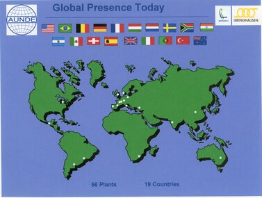
Photograph - Aunde Album 29, Global Presence Today, 2002
Aunde / Norwellan Textiles North Western Woolen Mills became Norwellan Textiles then AUNDEColour landscape photo: World map with flags, white dots showing locations of 56 plants in 19 coutries.Global Presence 56 plants in 19 Countries. Esteban logo, Isinghausen logo, Aunde logo with flagsindustry, aunde -
 Stawell Historical Society Inc
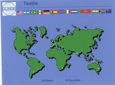
Photograph - Aunde Album 29, Textile Plants, 2002
Aunde / Norwellan Textiles North Western Woolen Mills became Norwellan Textiles then AUNDEColour landscape photo: Map of the world dots of locations and countries maps.Textile AUNDE logo 19 Plants, 14 Countries.industry, aunde -
Stawell Historical Society Inc
Map, Underground Mine Workings Stawell, 1894
Plan and Elevations of mine workings 12 September 1894. J H Bate Mining Surveyor. Framed under Glassstawell, mining, plans -
Stawell Historical Society Inc
Map, Township of Stawell Photo Map, 1947
Photograph of Stawell from Air Circa 1947. Shows mining sites and townshipmining, gold, map -
Stawell Historical Society Inc
Map, Department of Mines Victoria, The Reefs. The Principle Reefs at Quartz Reefs, 1868
c1868 Map showing the position of principal Reefs at Quartz ReefsTracing Shewing the position of the principle reefs at Quartz Reefs. Scale 8 Chains to an inch mining, gold, map -
Stawell Historical Society Inc
Map, Department of Mines Victoria, Alluvial Map Stawell Region, 1870's
c1870 Coloured map showing Black Range North to Stawell and Illawarra. Shows geological layout.Department Mines Victoria 1952/G/2 mining, gold, map -
Stawell Historical Society Inc
Map, Stawell Gold Mine, Provisional Plan Wonga Area, c1980
c1980 Preliminary Provisional Reconnaissance Plan Showing Workings Above and Below water LevelWonga Area 1:1000 Base Geological Sheet mining, gold, map -
Stawell Historical Society Inc
Map, Western Mining Stawell, Germania Summary Plan & Geology Western Mining Corporation, September 1988
Germania Summary Plan & Geopogy Western Mining Corporation Stawell VicGermania Summary Plan & Geology 2003-566 1:1000 mining, gold, map -
Stawell Historical Society Inc
Map, Geological Survey Office, Sloanes & Scotchmans united Mine, December 1916
Sloane & Scotchman's Geological Survey Map 1916 Showing Underground DrivesGeological Survey Office Ballarat December 1916 mining, gold, map -
Stawell Historical Society Inc
Map, Charles C Reilly, Oriental & North Cross Reef Mine showing underground drives, 3/5/1900
Underground Survey of Mines Stawell c1900Charles C Reilley 3.5.00 mining, gold, map -
Stawell Historical Society Inc
Map, Sloanes & Scotchmans Company showing underground drives, c1900
Underground Workings Mapc1900Sloanes & Scotchmans Coy mining, gold, map -
Stawell Historical Society Inc
Map, Gold Mines of Australia, Gold Mines of Australia underground workings. Newington Rd Darlington Rd Area 1950, 1950
Plans Showing Surveys & Drilling Stawell InvestmentGold Mines of Australia Stawell Investment 2003 mining, gold, map -
Stawell Historical Society Inc
Map, Gold Mines of Australia, Geological Plan Wonga Mine Area Stawell Investigation, 1950
Plans Showing Stawell Investment 1950Gold Mines of Australia Ltd mining, gold, map -
Stawell Historical Society Inc
Map, Gold Mines of Australia, Stawell Investment Geological Plan. Mine Area showing Mineshafts
The Reefs Mine shaft locationsGold Mines of Australia Ltd mining, gold, map -
Stawell Historical Society Inc
Map, G C Birch Mining Surveyor, Magdala Cum Moonlight Co. Plan of Stawell Goldfield, c1900
Shows Sloanes & Scotchmans Coy AreaShowing underground drives. c1900G C Birch Mining Surveyor mining, gold, map -
Stawell Historical Society Inc
Map, Western Mining Corp / Stawell Joint Venture, Stawell & District with Mine Working Areas shown in red, 1987
Covers from Magdala East site to Germania in North and Hand in Hand at West Legend of Mine workings numbered. 1980's mining, gold, map -
Stawell Historical Society Inc
Map, Stawell Gold Mine, SGM Mineralized System Longitudinal Projection showing Diamond Drilling Holes 2007, June 2007
Section of Big Hill showing Diamond Drill holes through Magdala, Magdala North and Golden Gift Ore bodies to 2000m levelLegend of Mine workings numbered. 1980's mining, gold, map -
Stawell Historical Society Inc
Map, Crocodile Gold Corp, Photographic Aerial View of Big Hill showing underground workings and surface workings and proposed Big Hill Open Pit proposal, December 2014
Crocodile Gold Corp SGM photo Map showing Magdala Decline& Wonga Decline December 2014 Produced for Public Consultation over Big Hill Open Pit Proposal. Aerial Views Stawellmining, gold, map -
Stawell Historical Society Inc
Map, Stawell Gold Mine, Stawell Gold Mine Photo Map of Stawell Township showing Underground Declines in mining lease, 2007
SGM photo Map 2007 Produced for Public Consultation over Big Hill Open Pit Proposal. Aerial Views Stawellmining, gold, map -
Stawell Historical Society Inc
Map, Western Mining Corp / Stawell Joint Venture, Cross Section of Shafts. Long Section Newington - Three Jacks Looking West, August 1991
WMC/SJV Cross Section Western Mining Corporation Limited Stawell Joint Venturemining, gold, map -
Stawell Historical Society Inc
Map, Western Mining Corp / Stawell Joint Venture, Aerial Photo of Wonga Open Cut and Tailings Dam No 2 proposed extension, January 1991
Shows proposed extension No2 Tailings Dam off Lavett Road and proposed Revegetation Corridors Western Mining Corporation Limited Stawell Joint Venturemining, gold, map -
Stawell Historical Society Inc
Map, Stawell Joint Venture, Map of Stawell showing Mining Lease Boundary and Freehold Land, September 1988
Stawell Joint Venturemining, gold, map -
Stawell Historical Society Inc
Map, Gold Mines of Australia, Plan of Stawell Goldfield. Mining Leases, 1952
And Shaft Locations 1952 G G Birch Mining Surveyormining, gold, map -
Stawell Historical Society Inc
Map, Stawell Joint Venture, Mine Site Detail Plan, September 1989
1989mining, gold, map