Showing 46142 items
matching main-hall
-
 Eltham District Historical Society Inc
Document - Property Binder, 801 Main Road, Eltham
1. Plan: Henry Dendy's Eltham Land 1857-1867: showing Diamond Creek, Bridge Street, Maria Street now Main Road, John Street, Pitt Street, St Margaret's Church 1861, and Eltham Community Centre 1987. 2. Photocopy extract from "Henry Dendy and his emigrants" by L A Schumer, re Portions 12 and 13, Parish of Nillumbik. 3. The President and Councillors of the Shire of Eltham request the pleasure of ____ at the Official Opening of the Eltham Community Centre, Cnr Main Road and Pitt Street, Eltham by the Honorable R.J. Hamer E.D., M.P., Premier of Victoria on Saturday, 22nd April, 1978 at 3.30pm 4. Souvenir Program, Opening of Eltham Community Centre 22 April 1975. 5. Invitation to attend Official Opening of Eltham Community Centre by R J Hamer, Premier of Victoria, 22 April 1975. 6. Flier for Eltham Reception and Conference Centre, photographs of interiors during events. 7. Newspaper article: Eltham buries present for the future, Diamond Valley News 19 November 1985 Eltham, photograph of burying time capsule outside Eltham Community Centre, photograph of Bill Baker and Sid Brown outside old blacksmith shop the original site of Eltham town centre. 8. Letter Peter Butler Shire of Eltham to Eltham District Historical Society, 6 July 1987, detailing process for naming of the halls at the Eltham Community Centre.6 July 1987. 9. Plan of Main Road Eltham - it depicts buildings and occupiers from Pitt Street to Luck Street in the first half of the 20th century. This plan was compiled as a joint efforts by members of the Shire of Eltham Historical Society at a general meeting in Eltham during the 1980s. Newspaper article: Swimming pool and community centre receive major revamps, Diamond Valley Leader, 21 October 2015.main road, eltham, eltham community centre, henry dendy, eltham reception and conference centre, bill baker, sidney brown blacksmith, tme capsule, arthur street, babe taylor house, bakery, boarding house, bradley house, bridge street, brown blacksmith, burgoyne's shop, cockcrofts store, commercial bank of australasia, david lyon house, davis, dr cordner, dr hall, dudley street, eltham hotel, eltham obelisk, eltham war memorial, garnet burges, graham, hawker, henry street, john lyon, len perron, luck street, lyons garage, map, mechanics insitute, monteith house, mrs morris shop, our lady help of christian’s primary school, panther place, pitt street, prior street, shillinglaw cottage, shops, stones mixed shop, websters house, wesleyan methodist church, york street -
 Eltham District Historical Society Inc
Photograph, Jim Connor, Main Road, Eltham, 14 Jan 2017
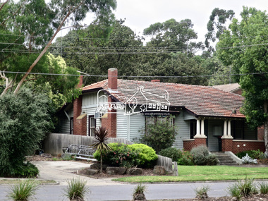
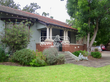
Eltham Gateway, Chiropractors, 856 Main Road, Eltham This Californian Bungalow style house is now the oldest surviving building in this vicinity of Main Road. Previously it was Dave Lyon’s original home and immediately to the right (carpark) was the location of his original motor garage – a tin shed witrh petrol bowsers out front. When Dave Lyon built a new garage opposite Arthuir Street, Charmac Industries then operated out of the tin shed. In early 2021 the house had a new coat of paint and a For Rent sign out frontTomorrow's history documented todayeltham, jim connor collection, main road, eltham gateway, chiropractor, dave lyon house -
 Eltham District Historical Society Inc
Photograph, Jim Connor, Main Road, Eltham, 14 Jan 2017
Eltham Gateway, Chiropractors, 856 Main Road, Eltham This Californian Bungalow style house is now the oldest surviving building in this vicinity of Main Road. Previously it was Dave Lyon’s original home and immediately to the right (carpark) was the location of his original motor garage – a tin shed witrh petrol bowsers out front. When Dave Lyon built a new garage opposite Arthuir Street, Charmac Industries then operated out of the tin shed. In early 2021 the house had a new coat of paint and a For Rent sign out frontTomorrow's history documented todayeltham, jim connor collection, main road, eltham gateway, chiropractor, dave lyon house -
 Eltham District Historical Society Inc
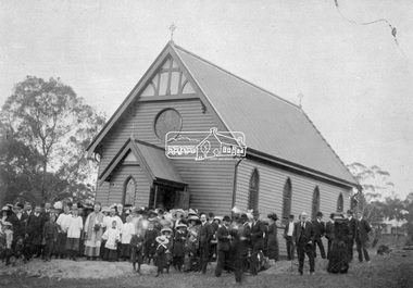
Negative - Photograph, St Mary's Catholic Church, cnr Main Road and Henry Street, Eltham, c.1912
St Mary's Catholic Church, cnr Main Road and Henry Street, Eltham was opened/blessed October 13, 1912. The wooden church was built to replace an earlier brick church also known as St Mary's (1865-1912), which had been situated on the main road near present day Wingrove Park. The church and land cost £1,400 (Evelyn Observer). The wooden church was destroyed by fire in 1961. Record includes a photo print copy of image as illustrated in the 'Diamond Valley News', 4 Feb 1998, p 31.This photo forms part of a collection of photographs gathered by the Shire of Eltham for their centenary project book,"Pioneers and Painters: 100 years of the Shire of Eltham" by Alan Marshall (1971). The collection of over 500 images is held in partnership between Eltham District Historical Society and Yarra Plenty Regional Library (Eltham Library) and is now formally known as the 'The Shire of Eltham Pioneers Photograph Collection.' It is significant in being the first community sourced collection representing the places and people of the Shire's first one hundred years.Digital image 4 x 5 inch B&W Negsepp, shire of eltham pioneers photograph collection, eltham, church, catholic church, henry street, main road, st marys catholic church -
 Ballarat Tramway Museum
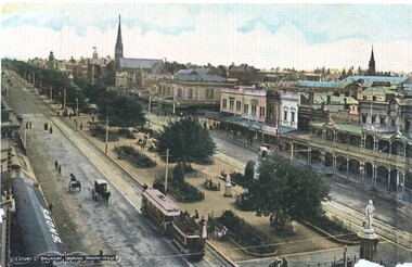
Postcard, Litho Coy and Ballarat, Sturt Street from the Town Hall Clock tower, c1900
Yields information about the operation of horse tram trailers behind electric trams and the appearance of Ballarat Sturt St c1906.Postcard - looking north west from the Town Hall clock tower, c1905 - 06 - with an ESCo electric tram hauling a loaded ex horse tram trailer. Has the Snows and the buildings on the north side of Sturt St in the view, including Anderson Morse Coach builders. Has the title "Sturt St Ballarat looking North West" in the bottom left hand corner. On the rear - divided back type with space for stamp, address and correspondence and the printer's name "Litho Coy, Ballarat". "$16" in stamp position in pencil.trams, tramways, sturt st, trailers, horse trams, esco -
 Kew Historical Society Inc
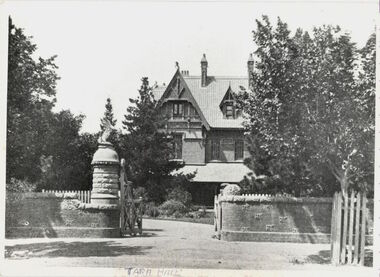
Photograph - 'Tara Hall', Studley Park Road
The chapter on Tara Hall formed the introduction to 'Lovely Old Homes of Kew' by Dorothy Rogers.This work forms part of the collection assembled by the historian Dorothy Rogers, that was donated to the Kew Historical Society by her son John Rogers in 2015. The manuscripts, photographs, maps, and documents were sourced by her from both family and local collections or produced as references for her print publications. Many were directly used by Rogers in writing ‘Lovely Old Homes of Kew’ (1961) and 'A History of Kew' (1973), or the numerous articles on local history that she produced for suburban newspapers. Most of the photographs in the collection include detailed annotations in her hand. The Rogers Collection provides a comprehensive insight into the working habits of a historian in the 1960s and 1970s. Together it forms the largest privately-donated collection within the archives of the Kew Historical Society.A photographic reproduction of a plate published by H. de C. Kellett in 1891. The original photographer was J.F.C. Farquaher. The photograph shows Tara Hall (the Byram) in Studley Park Road. The house was demolished in 1960.Tara Hall. Built 1888 (see story). Taken from old faded photo. Not printed. Tara Hall now demolished - taken from old faded photo of Clifton House. [sic]byram, goathland, tara hall, dorothy rogers, studley park road (kew) -
 Eltham District Historical Society Inc
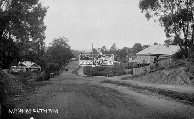
Negative - Photograph, Main Road, Eltham, c.1915
Sending postcards to family and friends including short messages was a common form of communication in the early 20th century from 1905 to the 1940s. Many were collected and kept in albums. This scene is viewed looking north along Main Road from near Bridge Street. The old Baker’s shop (Burgoyne’s store) on the corner of York is on the right. Also visible is the footpath dug by hand c.1906 between Yoirk Street and Bridge Street. On the left is ‘Derril’ or more commonly known as the Gahan House after it was purchased by Walter Ernest and Alice Miriam Gahan in 1924, on the western side of Main Road near the present-day site of Shillinglaw Cottage where they remained till about 1960 when Walter died. The house was demolished in 1968 during the widening of Main Road. In the distance on the bend is the Shillinglaw cottage with the Shillinglaw trees out front of the cottage. On the eastern side at the top of the hill (visible immediately to the left of the bakery) is the new St Mary’s Catholic Church on Henry Street near Main Road. The church site was relocated c.1912 from further south along Main Road (near Wingrove Cottage) in order to be more central to the congregation following the shifting of the township away from Little Eltham and closer to the railway station. It was subsequently destroyed by fire in 1961. On the back of the postcard is written: Printed Post Empire Care - correspondence - Address only - stamp Written in ink: 15 ? 1920 Many happy of the day I hope you and ? will have a very pleasant trip ? a great time when you reach England. ? & best wishes from your sincere friend E Harper?This photo forms part of a collection of photographs gathered by the Shire of Eltham for their centenary project book,"Pioneers and Painters: 100 years of the Shire of Eltham" by Alan Marshall (1971). The collection of over 500 images is held in partnership between Eltham District Historical Society and Yarra Plenty Regional Library (Eltham Library) and is now formally known as the 'The Shire of Eltham Pioneers Photograph Collection.' It is significant in being the first community sourced collection representing the places and people of the Shire's first one hundred years.Digital image 4 x 5 inch B&W Neg Sepia Postcard 9 x 14 cm 35mm positive transparencyshire of eltham pioneers photograph collection, eltham, main road, gahan house, bakery, footpath, postcard, shillinglaw cottage, shillinglaw trees, st marys catholic church, york street, michael aitken collection -
 Port Melbourne Historical & Preservation Society
Plan - Detail of Grille and Stairs, Port Melbourne Town Hall, Port Melbourne City Council, 1916
Plan - Details of grille to entrance and over main stair, details of main stairs. (1915 Town Hall)port melbourne town hall -
 Eltham District Historical Society Inc
Document - Property Binder, 1074 Main Road, Eltham
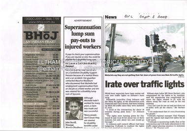
Newspaper article: Irate over traffic lights, Diamond Valley Leader, 3 September 2008, Peak hour traffic holdups at traffic lights Main Road Diamond Street and Cecil Street intersection.main road, eltham, businesses, diamond street eltham, cecil street eltham -
 Eltham District Historical Society Inc
Discussion paper, Community use of site, 895 Main Road, Eltham, 2003
Includes background notes of events leading up and after the demolotion of the former Shire of Eltham Offices at 895 Main Road Eltham. Discussions of proposals considered and relevance to the Nillumbik Council Plan 2002-2005. 8 Pagesnillumbik shire council, 895 main road -
 Eltham District Historical Society Inc
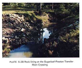
Work on paper (Sub-Item) - Photograph, Rock lining at the Sugarloaf-Preston transfer main crossing, 1976
Colour photograph of rock lining at the Sugarloaf-Preston transfer main crossing. The Sugarloaf Reservoir and the Winneke Water Treatment Plant (Winneke) are located 32 km north-east of Melbourne, near Christmas Hills. rock lining, water supply -
 Greensborough Historical Society
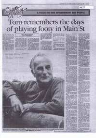
Newspaper Clipping, Diamond Valley News, Tom Vickers remembers the days of playing footy in Main Street, 12/12/1985
Greensborough chemist Tom Vickers recall the early days after he came to Greensborough 1941 - playing football in the Main Street, working closely with Doctor Cordner and delivering prescriptions to Hurstbridge via train.Photocopy of a news article, black and white text and image.tom vickers, cordner family, main street greensborough -
 Eltham District Historical Society Inc
Negative - Photograph, Eltham, Main Road, c.1910
Eltham, Main Road. Looking south from Henry Street towards Bakery (on left), c.1910 Mrs Davis house on left - Doug Orford recalled that there was always a dog on the couch on the front verandahThis photo forms part of a collection of photographs gathered by the Shire of Eltham for their centenary project book,"Pioneers and Painters: 100 years of the Shire of Eltham" by Alan Marshall (1971). The collection of over 500 images is held in partnership between Eltham District Historical Society and Yarra Plenty Regional Library (Eltham Library) and is now formally known as the 'The Shire of Eltham Pioneers Photograph Collection.' It is significant in being the first community sourced collection representing the places and people of the Shire's first one hundred years.Digital image 4 x 5 inch B&W Neg Print 20 x 25 cmsepp, shire of eltham pioneers photograph collection, eltham, main road, bakery, henry street, mrs davis house -
 Stawell Historical Society Inc
Photograph, Stawell Hospital from Main Street with Wimmera Street on left and Scotland Place on right c1930-1940
Stawell Hospital from Main Street 1930's- 1940's. Wimmera Street on left and Scotland Place on right. J.C. Zala Electrical Contractor and W.E. Coward Carpenter and Joiner signs on right.stawell hospital -
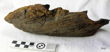 Flagstaff Hill Maritime Museum and Village
Wood Sample, 1854
This timber fragment is from the shipwreck of the SCHOMBERG (1855). The bow of the ship broke off after an unsuccessful salvage attempt to tow her off the Peterborough reef. At the wreck-site the submerged hull points north towards the beach but the front section is missing. Parts of the bow have been carried away by the eastward bearing ocean currents and have come ashore on the western coast of New Zealand’s South Island. Don Charlwood writes in Wrecks & Reputations (1977) that in 1871 “a piece of wreckage over 20 feet long and 12 feet wide was brought out” by land from its remote location at Tauperika Creek. In 1875 “an even larger section was brought out by sea”. It was suggested at the time that these relics of a large wooden sailing ship were from the wreck of the SCHOMBERG some 20 years earlier on the Victorian coast. “To corroborate the theory”, Charlwood continues, “a piece was sent to Halls of Aberdeen [the ship’s builders in Scotland]. They identified it as having come from the ship they had launched with such pride in 1852.” Charlwood, whose great-grandparents were passengers on the SCHOMBERG’s fateful maiden voyage, acquired some samples of the wreckage timber recovered in New Zealand, and brought them back with him to Australia. In 1976 “comparison was made of timbers from the New Zealand find and timber from the remains of the hull at Peterborough. They proved to be from the same ship.” The extraordinary journey of these pieces of wood from the once mighty clipper ship SCHOMBERG came to an end in 1984, when they were given to Flagstaff Hill by the author, and reunited with other shipwreck timbers and copper bolts from the vessel that are on display at the Maritime Village. The shipwreck of the SCHOMBERG is of State significance - Victorian Heritage Register S612The artefact is a small piece of wood that was broken from the timbers of the shipwreck of the SCHOMBERG (1855) and carried by the eastern currents to New Zealand (1875). It has 2 drilled holes that show faint screw marks and no metallic residue (possibly for patent treenails). The top surface is rounded, of a dark colour, and showing clear grains that have been worn smooth by the action of the sea. There is a reddish stain on the timber where breakage has occurred. The wood appears to have been strong in its original condition but is now light to lift and soft and crumbly at its exposed edges. The artefact is in fragile condition.flagstaff hill, warrnambool, shipwrecked-coast, flagstaff-hill, flagstaff-hill-maritime-museum, maritime-museum, shipwreck-coast, flagstaff-hill-maritime-village, schomberg, shipwreck timber, don charlwood, ‘wrecks & reputations’ -
 Flagstaff Hill Maritime Museum and Village
Wood Sample, 1854
This timber fragment is from the shipwreck of the SCHOMBERG (1855). The bow of the ship broke off after an unsuccessful salvage attempt to tow her off the Peterborough reef. At the wreck-site the submerged hull points north towards the beach but the front section is missing. Parts of the bow have been carried away by the eastward bearing ocean currents and have come ashore on the western coast of New Zealand’s South Island. Don Charlwood writes in Wrecks & Reputations (1977) that in 1871 “a piece of wreckage over 20 feet long and 12 feet wide was brought out” by land from its remote location at Tauperika Creek. In 1875 “an even larger section was brought out by sea”. It was suggested at the time that these relics of a large wooden sailing ship were from the wreck of the SCHOMBERG some 20 years earlier on the Victorian coast. “To corroborate the theory”, Charlwood continues, “a piece was sent to Halls of Aberdeen [the ship’s builders in Scotland]. They identified it as having come from the ship they had launched with such pride in 1852.” Charlwood, whose great-grandparents were passengers on the SCHOMBERG’s fateful maiden voyage, acquired some samples of the wreckage timber recovered in New Zealand, and brought them back with him to Australia. In 1976 “comparison was made of timbers from the New Zealand find and timber from the remains of the hull at Peterborough. They proved to be from the same ship.” The extraordinary journey of these pieces of wood from the once mighty clipper ship SCHOMBERG came to an end in 1984, when they were given to Flagstaff Hill by the author, and reunited with other shipwreck timbers and copper bolts from the vessel that are on display at the Maritime Village. The shipwreck of the SCHOMBERG is of State significance - Victorian Heritage Register S612A piece of wood broken from the timbers of the shipwrecked SCHOMBERG (1855, Peterborough) and retrieved from the southwest coast of New Zealand’s South Island. The artefact is a light grey colour with plain long grain and bears a reddish stain on parts. Part of a drilled hole is red stained with traces of corroded metal still evident. The piece appears to have split off from other fragments that are in the Flagstaff Hill collection (6257, 6258) and it is in fragile condition.flagstaff hill, warrnambool, shipwrecked-coast, flagstaff-hill, flagstaff-hill-maritime-museum, maritime-museum, shipwreck-coast, flagstaff-hill-maritime-village, schomberg, shipwreck timber, don charlwood, ‘wrecks & reputations’ -
 Eltham District Historical Society Inc
Photograph - Digital Photograph, Marguerite Marshall, Strathewen Public Hall, 20 August 2008
Strathewen Public Hall, social and spiritual centre was later lost in the Black Saturday fires 2009. The Strathewen Community decided a community hall was needed in 1901. In 1902 locals built the hall with messmate trees. It was located on the Cottlesbridge-Strathewen Road. The first function was a Grand concert and Balll attended by about 120 people. Several denominations held Church services and Sunday School services in the Hall. It survived several bushfires until after this photo was taken when it was destroyed in Black Saturday, 9 February 2009. Published: Nillumbik Now and Then / Marguerite Marshall 2008; photographs Alan King with Marguerite Marshall.; p89 Strathewen was settled late, largely because it was difficult to access.1 Early selectors found it a struggle to survive. They had to do everything themselves, from felling trees for buildings, to taking produce to market along bush tracks that they had helped cut. Small dairy farms were typical but fruit became the district’s prime produce. The first settlers east of Arthurs Creek were brothers John and Duncan Smith whose station Glen-Ard was probably operated as a sheep run. Other early settlers were the Mann family, who were to donate land for the hall, provide postal services and John Mann was an Eltham Shire councillor from 1916 to 1919.2 In 1873 James Mann, his wife Jane and their six children, settled on 207 acres (83.7) (Lang Fauld Farm) on both sides of Eagles Nest Road, from the foot of Mount Sugarloaf to the bank of the Arthurs Creek. In 1883 James took up another selection on Chads Creek. It was very hard work and at times he was well behind with his rent. However the family had a good social life, attending the Primitive Methodist Church at the Arthurs Creek Township and on New Year’s Eve throwing a party for all the locals. By 1874 James Mann’s younger brother, John, selected 311 acres (125.8ha) between Eagles Nest Road and upper Arthurs Creek. He called it Carseburn after his home parish in Scotland. Tragically in 1875 John drowned in the Yarra River, at Richmond.3 John Mann’s oldest son, also John, later purchased Duncan Smith’s land, which he named Violet Glen. He was to give one acre (0.4ha) of this land for the Strathewen Hall site. A Mann family diary written at Carseburn in 1897, tells how the district’s name was selected. Strathewen is derived from ‘strath’ meaning ‘broad mountain valley’ and from the name of Ewen H. Cameron, the local parliamentarian for almost 40 years. ‘George Brain came around to get a petition signed to get a post office up here and we had to vote for a name—Strathewen, Glen-Ard, or Headcorie’.4 It was at Carseburn that a public meeting in 1901, decided to build the Strathewen Hall on the Cottlesbridge-Strathewen Road. In 1902 the locals built the hall with messmate trees. The first function was a Grand Concert and Ball attended by around 120 people and several Protestant denominations took turns to hold church services and Sunday School there. Fortunately the hall has survived bushfires to be the town’s spiritual and social centre.5 The area continued to develop and in 1909 a post office operated somewhere at Strathewen and from around 1916 at Carseburn.6 It was not until 1914 that land was bought to establish the Strathewen State School on School Ridge Road. The residents paid £100 to build it on two acres (0.8 ha) while the Education Department contributed £30 and leased the building annually for £1. When teacher Miss Mary Golding opened the school in 1917, it had no equipment.7 But in 1921 the Education Department provided desks and a hexagonal shelter shed (now a rare style in Victoria) and took control in 1925.8 By 1917 Strathewen was booming.9 George Apted had built a coolstore in 1916, and local orchardists bought storage space until the 1950s. This allowed the area to supply the market in and out of season. Guesthouses catered for growing tourism. In the mid 1920s Mrs Eleanor Sparkes built the guest-house Singing Waters, which operated through the 1930s. Her daughter Mrs Vera McKimmie, ran it until the 1950s and the house remains in Chads Creek Road. In the Great Depression land was cleared for timber to be sold as firewood and there was small scale sawmilling. However the orchard industry diminished for several reasons including the 1939 bushfires and rapid changes in production methods. Today the Apteds still operate an orchard and farm at Glen-Ard, which straddles the border between Strathewen and Arthurs Creek. It includes the southern part of Duncan Smith’s original Glen-Ard selection.This collection of almost 130 photos about places and people within the Shire of Nillumbik, an urban and rural municipality in Melbourne's north, contributes to an understanding of the history of the Shire. Published in 2008 immediately prior to the Black Saturday bushfires of February 7, 2009, it documents sites that were impacted, and in some cases destroyed by the fires. It includes photographs taken especially for the publication, creating a unique time capsule representing the Shire in the early 21st century. It remains the most recent comprehenesive publication devoted to the Shire's history connecting local residents to the past. nillumbik now and then (marshall-king) collection, strathewan public hall -
 Ballarat Heritage Services
Photograph, Clare Gervasoni, Savoia Hotel, Hepburn Springs, 25/02/2021
Now known as the Savoia Hotel, the original Savoia House was present behind a new brick front until refurbishments in 2022.Colour photograph of Savoia Hotel, Main Road, Hepburn Springs. The hotel is an important site for the Swiss/Italian Community."A focal point for Italian speakers; in 1857 the site included Lorenzo's blackmsiht, Faustino's show shop, Sr Rosetti's Union Store and Giovanettina's Lemonade Store." Swiss & Italian Festa Committee 2012savoia hotel, spring creek hotel, hotels, hepburn springs -
 Ballarat Heritage Services
Photograph, Clare Gervasoni, Savoia Hotel, Hepburn Springs, 06/2023
Now known as the Savoia Hotel, the original Savoia House was present behind a new brick front until refurbishments in 2022.Colour photograph of Savoia Hotel, Main Road, Hepburn Springs. The hotel is an important site for the Swiss/Italian Community."A focal point for Italian speakers; in 1857 the site included Lorenzo's blackmsiht, Faustino's show shop, Sr Rosetti's Union Store and Giovanettina's Lemonade Store." Swiss & Italian Festa Committee 2012savoia hotel, spring creek hotel, hotels, hepburn springs -
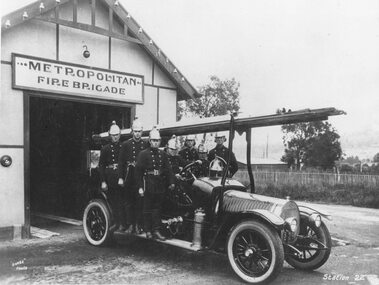 Ringwood and District Historical Society
Photograph, Ringwood Fire Brigade - Old Station at rear of Old Town Hall in Melbourne Street - 1929
Black and white photograph of firemen in fire truck outside fire station. (3 copies)Caption below photograph reads, "Ringwood Fire Brigade - Old Station at rear of Old Town Hall in Melbourne Street - 1929" Written on backing sheet, "1. George Burns, 2. Sam Brown, 3. David Anderson, 4. Les Jones (Driver), 5. Clarence Burns, 6. Roy Sedgman, 7. Jack Wilkins. 1912 Hotchkiss". -
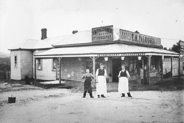 Ringwood and District Historical Society
Photograph, Maroondah Highway Central, Ringwood. Falconer store, corner Main Street & Adelaide Street, c1909
Black and white photograph (2 copies- 1 original, 1 copy) Photograph shows 3 men standing at front of shop owned by T. M. Falconer- General Storekeeper. Written on back of original photograph: "Original holder- Tom Falconer, Norman Bros. c/r Main & Adelaide Sts". Photographed by George Wall, St. Kilda, Melbourne. -
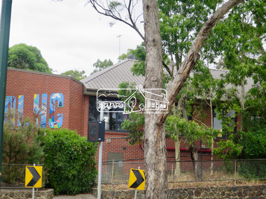
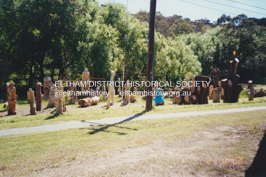 Eltham District Historical Society Inc
Photograph, Fay Bridge, Leigh Conkie's chainsaw sculptures, Main Road, Eltham, 21 October 2000
These chainsaw sculptures were created by Leigh Conkie at his home in Main Road. There were so many at times it would be a regular sight to see them sprawled across the public reserve adjacent to his home.fay bridge collection, 1305 main road, 2000-10-21, chainsaw sculpture, eltham, leigh conkie, main road -
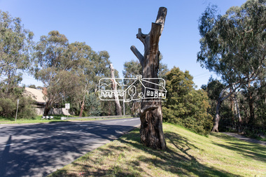
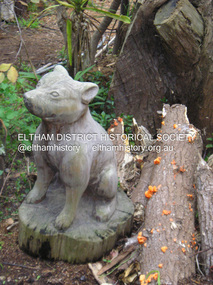 Eltham District Historical Society Inc
Photograph, Fay Bridge, Leigh Conkie's chainsaw sculptures, Main Road, Eltham, n.d
These chainsaw sculptures were created by Leigh Conkie at his home in Main Road. There were so many at times it would be a regular sight to see them sprawled across the public reserve adjacent to his home.fay bridge collection, 1305 main road, chainsaw sculpture, eltham, leigh conkie, main road -
 Eltham District Historical Society Inc
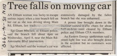
Document - Property Binder, 606 Main Road, Eltham
Newspaper article: Tree falls on moving car, Diamond Valley News, 15 April 1998, tree fell near Main Road and Antoinette Boulevard intersection, damaging car, power line and street light.main road, accident, eltham (vic) -
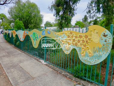
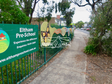 Eltham District Historical Society Inc
Photograph, Jim Connor, Main Road, Eltham, 14 Jan 2017
Eltham Gateway, Mural, Eltham Pre-school, 907 Main Road, Eltham "We are glad the people of Eltham built this special place for children in 1956." The pre-school celebrates its 65th anniversary in 2021.Tomorrow's history documented todayeltham, jim connor collection, main road, eltham gateway, eltham pre-school, eltham war memorial, war memorial buidings -
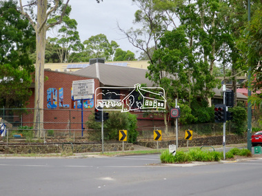
 Eltham District Historical Society Inc
Photograph, Jim Connor, Main Road, Eltham, 14 Jan 2017
Eltham Gateway, Our Lady of Help of Christians Primary School, 1-13 Henry St, Eltham viewed looking south from near the CFA building across Main Road to Dudley Street intersectionTomorrow's history documented todayeltham, jim connor collection, main road, eltham gateway, dudley street, our lady help of christians primary school -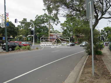
 Eltham District Historical Society Inc
Photograph, Peter Pidgeon, Manna Gum, Main Road, Eltham South, 8 Sep. 2021
This significant tree located near the Main Road Bridge over the Diamond Creek at Eltham dates back to approximately 1870-1880. Though dead now, its trunk has been left as a wildlife habitat.These trees are not only significant for the natural environment but also present a navigational beacon back in time as the environmental landscape is developed around them.Born Digitaleltham south, main road bridge, manna gum, significant tree