Showing 6699 items
matching river
-
 Greensborough Historical Society
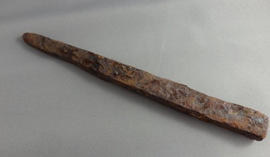
Spike, Hand forged metal spike, 1900c
Hand forged metal spike found along Plenty River.Hand forged metal spike. Some rust. -
 Greensborough Historical Society
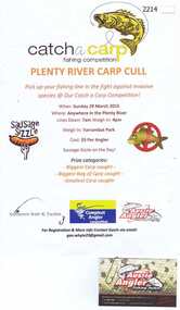
Advertising Poster, Aussie Angler, Catch a carp fishing competition, 29/03/2015
Flyer advertising the Plenty River carp cull March 2015Colour advertisement. Attached is business card.aussie angler, plenty river -
 Eltham District Historical Society Inc
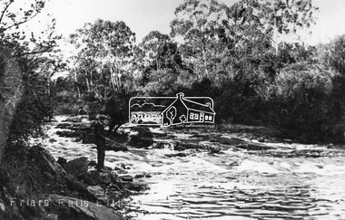
Negative - Photograph, Tom Prior, Friars Falls, Eltham, c.1910
Friars Falls is near Griffith Park, Eltham on the Yarra RiverThis photo forms part of a collection of photographs gathered by the Shire of Eltham for their centenary project book,"Pioneers and Painters: 100 years of the Shire of Eltham" by Alan Marshall (1971). The collection of over 500 images is held in partnership between Eltham District Historical Society and Yarra Plenty Regional Library (Eltham Library) and is now formally known as the 'The Shire of Eltham Pioneers Photograph Collection.' It is significant in being the first community sourced collection representing the places and people of the Shire's first one hundred years. The Reynolds family were early settlers in Research. The Reynolds/ Prior collection of photographs were taken by Tom Prior, the maternal uncle of Ivy Reynolds, around 1900 and the 60 photos in the album give a fine overview of many of the landmarks of Research and Eltham over 100 years ago. lvy lived in the family home for many years at 106 Thompson Cres Research. Ivy's father, Ernst Richard Reynolds and grandfather, Richard Reynolds, lived at the same address. Ivy's father Richard worked for Mr. Trail on his property in Research. Reynolds Road is named after the family. Mr Tom Prior (wife Eva) worked at the Melbourne zoo. He was very innovative and made his own camera, using the black cloth hood to exclude the light. The photographs are a reminder of the rural nature of Research and Eltham and its rich heritage.Digital image 4 x 5 inch B&W Negshire of eltham pioneers photograph collection, eltham, friars falls, griffith park, yarra river, reynolds prior collection -
 Tatura Irrigation & Wartime Camps Museum
Photograph, Goulburn Waranga No.2 Main Channel, 1957
Taken by the photographer for Victoria State Rivers and Water Supply Commission.Large sepia photograph dry mounted to cream board. Excavated channel with three levels - water in the lowest level, truck facing forward, second level, gang of workmen far distant on lowest level. Trees on horizon beyond top of bank.Below photo: "Goulburn-Waranga No.2 Channel"irrigation, channel, goulburn, waranga, victoria state rivers and water supply commission -
Tatura Irrigation & Wartime Camps Museum
Photograph, The Goulburn-Waranga Main Channel, 1957
Taken by the photographer for Victoria State Rivers and Water Supply Commission.Sepia photograph - dry mounted on cream cardboard. Wide view of water-filled channel, trees lining each bank Large photographAbove photo - "The Goulburn Waranga Main Channel"irrigation, goulburn, waranga, victoria state rivers and water supply commission, channel -
Tatura Irrigation & Wartime Camps Museum
Photograph, East Goulburn Main Channel, 1957
Taken by the photographer for Victoria State Rivers and Water Supply Commission.Large sepia photograph dry mounted on cream cardboard. 15" diameter concrete pylon, wooden scaffolding, with two men, left foreground, looking up into syphon mouth, one pointing right arm and index finger of right hand.Below Photo: "East Goulburn Main Channel / Construction of 15" Diameter Concrete Syphon" irrigation, goulburn, victoria state rivers and water supply commission, channel -
Tatura Irrigation & Wartime Camps Museum
Photograph, Goulburn-Waranga Channel, 1957
Taken by the photographer for Victoria State Rivers and Water Supply Commission.Large sepia photograph Dragline left of centre, with scoop bucket in action, right of centire, two men left of dragline cabin - wall of earth in foreground.Above photo: "Goulburn - Waranga Channel / Bucyrus 200W Walking Dragline"irrigation, goulburn, victoria state rivers and water supply commission, channel, dragline, bucyrus 200w -
Tatura Irrigation & Wartime Camps Museum
Photograph, Cattanach Canal, 1957
Taken by the photographer for Victoria State Rivers and Water Supply Commission.Large black and white photograph. Water in lowest level of canal, three levels of embankment shown on either side, rock fill left foregroundBelow photo: "Cattanach Canal"irrigation, victoria state rivers and water supply commission, cattanach canal -
Tatura Irrigation & Wartime Camps Museum
Photograph, Cattanach Canal, 1957
Taken by the photographer for Victoria State Rivers and Water Supply Commission.Large sepia photograph - water filled channel inlet and bank - Man standing on platform looking down on concrete wall of measuring weir.Above photo: "Cattanach Canal / Inlet and Measuring Weir to Waranga Basin."irrigation, victoria state rivers and water supply commission, cattanach canal -
Tatura Irrigation & Wartime Camps Museum
Photograph, Cattanach Canal, 1957
Taken by the photographer for Victoria State Rivers and Water Supply Commission.Large sepia photograph - large stretch of water in foreground, men leaning down from platform above measuring weir in middle of photograph - trees on bank left and middle distance.Above photo: "Cattanach Canal / Inlet and Measuring Weir to Waranga Basin."irrigation, victoria state rivers and water supply commission, cattanach canal, waranga basin, measuring weir -
Tatura Irrigation & Wartime Camps Museum
Photograph, Cattanach Canal, 1957
Taken by the photographer for Victoria State Rivers and Water Supply Commission.Large sepia photograph - Concrete structure, side wings, three centre supports, platform and framework above. Man standing, looking up from base. Cracked earth floor and embankment.Above photo: "Cattanach Canal / Regulator on Connection to No.1 Main Channel"irrigation, victoria state rivers and water supply commission, cattanach canal -
Tatura Irrigation & Wartime Camps Museum
Photograph, Cattanach Canal, 1957
Taken by the photographer for Victoria State Rivers and Water Supply Commission.Large sepia photograph - Construction equipment middle foreground, two bridges, truck crossing second bridge, trees, flat paddock, scattered trees, man working on nearer concrete bridge support.Below photo: "Cattanach Canal / Rail and Highway Bridges near Murchison"irrigation, victoria state rivers and water supply commission, cattanach canal, bridges -
Tatura Irrigation & Wartime Camps Museum
Photograph, Weed clearing - irrigation channel, 1957
Taken by the photographer for Victoria State Rivers and Water Supply Commission.Large black and white photograph Irrigation channel, weed clearing equipment in operation middle. Male operator, male observer behind, long unkempt weeds both sides of channelBelow photo: "Cleaning weeds and Silt from Supply Channel near Tatura"irrigation, victoria state rivers and water supply commission, channel maintenance -
Tatura Irrigation & Wartime Camps Museum
Photograph, New Fence Styles - Irrigation Channels, 1957
Taken by the photographer for Victoria State Rivers and Water Supply Commission.Large black and white photograph Concrete "fence" styles - One male worker handling sample in mid-distance, right of centre.Below photo: "New Fence Styles to enable easy access onto Commission Channel Reserves."irrigation, victoria state rivers and water supply commission, channel maintenance -
Tatura Irrigation & Wartime Camps Museum
Book, State Rivers and Water Supply Commission Annual Reports 1930 - 45
Old report from the State Rivers and Water Supply Commissionvictoria state rivers and water supply commission -
Tatura Irrigation & Wartime Camps Museum
Book, State Rivers and Water Supply Commission Annual Reports 1945 - 50
Old report from the State Rivers and Water Supply Commissionvictoria state rivers and water supply commission -
Tatura Irrigation & Wartime Camps Museum
Book, State Rivers and Water Supply Commission Annual Reports 1950 - 55
Old report from the State Rivers and Water Supply Commissionvictoria state rivers and water supply commission -
Tatura Irrigation & Wartime Camps Museum
Book, State Rivers and Water Supply Commission Annual Reports 1955 - 60
Old report from the State Rivers and Water Supply Commissionvictoria state rivers and water supply commission -
Tatura Irrigation & Wartime Camps Museum
Book, State Rivers and Water Supply Commission Annual Reports 1962 - 67
Old report from the State Rivers and Water Supply Commissionvictoria state rivers and water supply commission -
Tatura Irrigation & Wartime Camps Museum
Book, State Rivers and Water Supply Commission Annual Reports 1967 - 71
Old report from the State Rivers and Water Supply Commissionvictoria state rivers and water supply commission -
Tatura Irrigation & Wartime Camps Museum
Book, State Rivers and Water Supply Commission Annual Reports 1971 - 76
Old report from the State Rivers and Water Supply Commissionvictoria state rivers and water supply commission -
Tatura Irrigation & Wartime Camps Museum
Book, State Rivers and Water Supply Commission Annual Reports 1976 - 79
Old report from the State Rivers and Water Supply Commissionvictoria state rivers and water supply commission -
Tatura Irrigation & Wartime Camps Museum
Book, State Rivers and Water Supply Commission Annual Reports 1979 - 82
Old report from the State Rivers and Water Supply Commissionvictoria state rivers and water supply commission -
Tatura Irrigation & Wartime Camps Museum
Letter - Camp 13 History, Cattanach Canal History Residents of Camp 13 Murchison During Period 1952 - 1956
3 Typed pages stapled at top left corner, type colour is purple. Also a handwritten post script on last page. non-fiction -
 Tatura Irrigation & Wartime Camps Museum
Photograph, State Rivers & Water Supply Commission Office
State Rivers & Water Supply Commission Office, Casey Street,photograph, people -
 Malmsbury Historical Society
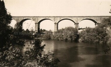
Postcard (Item), "Postcard Of The Viaduct Malmsbury, Rose Series P4159", Malmsbury c1923
Associated with - Rose Series P4159 Buildings - "Viaduct, Coliban River" -
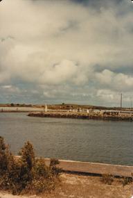 Port Fairy Historical Society Museum and Archives
Photograph
Martin's Point from battery hill side of Moyne riverColoured photograph of Martins Point with people fishing on the bankmartins point, moyne river, fence, signal -
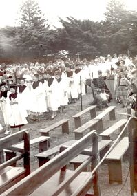 Port Fairy Historical Society Museum and Archives
Photograph
St John’s choir processing toward the river Blessing of the FleetBlack and white photograph St John’s choir in white robes with wide collars and mortar board style hats, wooden benches in forgroundevents, civil, ceremony, choir, st johns, blessing of the fleet, moyne river -
Whitehorse Historical Society Inc.
Map - WW1 Trench map, Belgium collected by C H Honybun, Belgium WW1 map, Aug 1917
WW1 map of Belgium Edition 1. Sheet 28 S.W. and S.E. with trenches in red around the towns of Comines and Warnetonnon-fictionWW1 map of Belgium Edition 1. Sheet 28 S.W. and S.E. with trenches in red around the towns of Comines and Warnetonworld war 1914 - 1918, maps -
 Ballan Shire Historical Society
Map - Map. Shire of Ballan, Shire of Ballan
This is a fairly comprehensive map of the former Shire of Ballan which is now amalgamated into the Shire of Moorabool.A black and white map of the Shire of Ballan showing major roads, rivers, towns, settlements, State parks and forests and land subdivisions. It appears to be a copy of the original as no dates or maker or printer appear on the map. There is a scale of 2 miles to 1 inch.gordon, ballan, bungal, kerrit bareet, borhoneyghurk, bungeeltap, ballark, yaloak, gorong, beremboke, wallace, ingliston, hunterston, millbrook, bradshaw, myrniong, blackwood, moorarbool, greendale, bayup, trentham, bullarto, korweinguboora, glenlyon, bolwarra