Showing 10429 items
matching sites
-
 Bendigo Historical Society Inc.
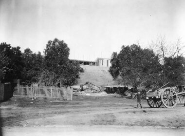
Photograph - Victoria Hill, Bendigo, 1973
Gold was discovered on Victoria Hill in 1854 and by 1861, 1,200,000 ounces of gold had been extracted from the site. The first claim was bought for 80 pounds by Prussian immigrant Christopher Ballerstedt and his son Theodore. Christopher Ballerstedt was nicknamed the "Father of the Hill" and was the first to prove that gold reefs extended below the surface. His 200-foot plus mine shafts yielded quartz rich with gold, inspired other miners, and were instrumental in Bendigo becoming the world's deepest and richest goldfield. The site still features relics of nineteenth century mining including quartz crushing machinery and the foundations of George Lansell’s 180 mine. These features are characteristic of Bendigo’s mining history and represent two prominent nineteenth century miners, Christopher Ballerstedt and George Lansell, who held important roles in the development of Bendigo. Victoria Hill Quartz Gold Mines are registered as a site of significance. The site is of historical, archaeological and scientific importance to Victoria. The mines represent the symbolic heart of Bendigo’s gold mining history and the importance that mining played in wealth creation and the development of Victoria. The diggings reserve is accessed from the rear of Albert Richardson Reserve located at 40-56 Marong Road, Ironbark. The site has steep and unformed paths and is closed to the public at dusk. It is important to stay to the paths to avoid the diggings. Interpretive signs help visitors to appreciate the importance of the site and the remaining relics of Bendigo’s mining history.Victoria Hill Ironbark, Bendigo. Photos of the poppet head, sand heap, tailings, shafts and tunnels. Before development into a tourist attraction.history, bendigo, victoria hill, ironbark, diggings -
 Eltham District Historical Society Inc
Photograph, Fay Bridge, Footbridge, Fort Knox Self Storage, 197 Sherbourne Road, Eltham, n.d
The footbridge which extended from the facility to the landscaped garden and water features is now gone. The footbridge and garden were previously part of a former hat factory in Sherbourne Road Eltham which has in the past been used for various purposes and presently a self storage business. The Karingal Yallock Creek passes through the front of the land and the creek environs are the subject of significant and unusual landscaping works, including some cascading water channels. Some of the landscaping was damaged by the Christmas Day floods of 2011, but the main elements remain intact. The landscaped area (as distinct from the factory itself) is the subject of a Heritage Overlay under the Nillumbik Planning Scheme. The basis of this overlay is a Heritage Report by Graeme Butler and Associates in 2006. As well as an assessment of the landscaped area, it includes one background information on the history of the site (although a complete history would require more research). The site was part of Crown Portion 3 of the Parish of Nillumbik that remained as the Montmorency Farm until early in the twentieth century. The 1911 subdivision of this farm created Lot 7 of some seven acres, which is the site of this factory. The Heritage Report lists the various owners of the site. From the rate records and aerial photos it is concluded that the site was used as an orchard and farmland until the 1940s. William F Crellin, orchardist, owned the site from 1912 to 1923. Then Edmund Williams owned it until 1951. In 1955 the site was owned by Rupert V. Kirsch and this is the name anecdotally associated with the hat factory, where the well-known brand of Fayrefield Hats were manufactured. There is some belief that this was built about the time of the Second World War and that hats for the armed forces were made there.fay bridge collection, eltham, fayrefield hat factory, foot bridge, sherbourne road, footbridge, fort knox eltham -
 Bendigo Historical Society Inc.
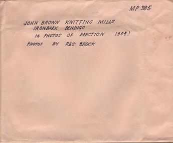
Photograph - HANRO COLLECTION: PHOTOGRAPHS OF THE ERECTION OF JOHN BROWN KNITTING MILLS, 1954
Photographs of the Erection of John Brown Knitting Mills: A brown envelope which had hand printed writing in black ink. On the right hand top is *MP385*. In the middle *John Brown Knitting Mills Ironbark Bendigo. 14 Photos of Erection 1954? Photos by Reg Brock*. Attached to the envelope is a torn piece so paper which has been hand written in blue ink *John Brown & Welmar* Knitwear Socks & Dress wear The Finest in the Land. Made on the site of Bendigo's Richest Gold Mine, *The Little 180*. Inside the envelope is a collection of black and white photos of the erection of the John Brown Knitting Mills on Marong Road in Ironbark Bendigo. 14 Photos in total showing various views of the construction site. Workmen on the site laying bricks, constructing the steel building and trucks delivering steel etc. A crane truck with *General Carriers Bendigo* printed on the side door. On the back of each photo is *MP385*. The Circular stamp in blue ink of the Royal Historical Society of Victoria Bendigo Branch and a cream photographers label with a blue band top and bottom with *Reg. V. Brock of Bendigo in the bands. In the centre of the label in blue print is *No.... B1098. pos.... Additional copies may be obtained at any time by quoting this number. Box 116A.Reg. V. Brock of Bendigo.photograph, building, john brown, john brown knitting mills -
 Ringwood and District Historical Society
Photograph, Burnt Bridge Store, Feb 1960 (2 views)
Written on back of one photograph, "Burnt Bridge Store. Demolished 1969. New World super market and shops built on or about site. Feb. 1960". On another copy "Ex BB Hotel, Demolished 3-4.69". On another copy: "Old Burnt Bridge Hotel (Sam Cutts)" -
 Stawell Historical Society Inc
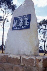
Slide, Ian McCann, Monuments Doctors Hill
Monument to mark where the first hospital was built at Pleasent CreekDoctor's Hill On this Hill in 1859 the First Pleasant Creek Hospitalwas built to serve the needs of the Gold Miners and the Rural Communities of Western Victoria. "There not being Anything Else of the kind further towars the interior of the Colony.' [1st Annual Report 1859]. The Hospital Was Re-sited to Stawell West in 1861doctors hill, monument -
 Rutherglen Historical Society
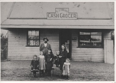
Photograph - Image, c1903
Black and white matt photograph of SJ Yourn Cash Grocers at North Prentice with man and six children in frontOn back of photo: "J.H. Yourn & Family | Taken at North Prentice circa 1903 | Located immediately south of North Prentice State School site | Irene (King), Winnie (Herd), Alice (Withers), Florence (Nash), Gladys (Grant) | On chair James Norman & father John Henry Yourn"yourn cash grocers, north prentice, yourn family, james norman yourn, john henry yourn, irene king, winnie herd, alice withers, florence nash, gladys grant -
 Greensborough Historical Society
Article, The 1909 "Battle of Greensborough" / by John Gibson, 1909_
In 1909 military exercises were held in the Greensborough area. In this researched article the site is identified and activities related.This is the text of a presentation by John Gibson at the April 2013 meeting of GHS.2 pages, text, map and photograph.sugarloaf hill, bundoora, john gibson, greswell hill, latrobe house -
 Greensborough Historical Society
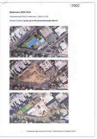
Article and Photograph, Watermarc 2009-2016, 2016_
Aerial photographs of the Greensborough Pool site being redeveloped into WaterMarc (2009-2016). Images from nearmap.com.auThis text and photographs were copied from a Facebook site. Members are people who lived in the Greensborough area and share their reminiscences of the area with others. The site is administered by a GHS member but is not officially affiliated with the Society. Any information is the opinion of the contributor. Photographs and text sourced from social media.greensborough pool, watermarc -
 Greensborough Historical Society
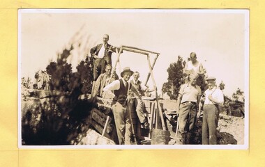
Photograph - Digital Image, Mystery mine photographs: Workers at top of shaft, 1935c
This photograph shows workers at the mine site, at the top of the mine shaft. A ladder can be seen at centre of photo..An interesting collection of photographs, the connection to Greensborough remains a mystery. Digital copy of black and white photograph, one of 30 photos of mining operations. Photos have no markings or dates. Donor unknown.tasmania, mines and mining, mining machinery -
 Greensborough Historical Society
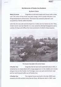
Article, Norm Colvin, My memories of Poulter Ave residents, by Norm Colvin, 28/07/2016
Details of the development and occupation of sites in Poulter Avenue and Bicton Street Greensborough, compiled by resident Norm Colvin.12 pages, text, black and white photographs and colour subdivision plan.poulter avenue greensborough, bicton street greensborough -
 Greensborough Historical Society
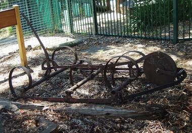
Photograph - Digital Image, Marilyn Smith, Partington scarifier, 1960s
This scarifier was donated to the Greensborough Historical Society by the Partington family. It was last used at the site of Whatmough Park in the 1960s.Digital copy of colour photographsgreensborough historical society, partington family -
 Greensborough Historical Society
Photograph - Digital image, John Gibson et al, Luxford home in Main Street, 1950s
The Luxford home in Main Street Greensborough, rented from Mr Jessop. Chemist Warehouse is now on this site.Digital copy of black and white photograph. luxford family, main street greensborough, cecil jessop -
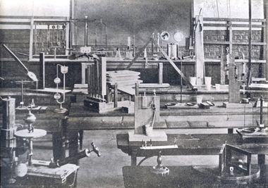 Federation University Historical Collection
Photograph, Ballarat School of Mines Physics Laboratory, c1908
The Ballarat School of Mines was the first site of Technical Education in Australia. Initially it opened in 1870 and educated miners. Black and white photograph of the interior of the Ballarat School of Mines Physics Laboratory. Numerous pieces of equipment sit on benches. The image in the 1908 Ballarat School of Mines Calendar was title 'Physics Demonstration Room'.ballarat school of mines, laboratory, physics, scientific instruments, science, classroom, education -
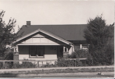
 Robin Boyd Foundation
Document - Manuscript, Robin Boyd, The Baker House, Bacchus Marsh, Victoria, Australia, 1966
Description of Baker family, site and house. Choice of slate building material, water tanks and arrangement of spaces.Published as 'Baker House, Bacchus Marsh, Victoria: Architects - Romberg and Boyd' in "World Architecture 3", edited by John Donat (1966).Typewritten, quarto, 2 pagesPencil annotationsbaker family, baker house, bacchus marsh, slate, water tanks, residential architecture, site analysis, robin boyd, manuscript -
 Robin Boyd Foundation
Document - Manuscript, Robin Boyd, Tokyo Cathedral, c. 1965
A detailed critique of Kenzo Tange's St Mary's Cathedral, Tokyo and experience of visiting the site. (later published asPublished as "A Cruciform Window onto Heaven" in "Architectural Forum", vol. 123, no. 2, September 1965, pp. 50-55.Typewritten (c copy), foolscap, 4 pages. (Three copies)st mary's cathedral, tokyo, kenzo tange, hiroshima, tokyo olympic games, hyperbolic paraboloid, japan, robin boyd, manuscript -
Tatura Irrigation & Wartime Camps Museum
Photograph, Arthur Knee, 1989
Camp 13, concrete pit, rolled barbed wire, near site of Camp 13 administration area.Camp 13, Camp Road, Murchison, Victoria. Concrete pit and tangled barbed wire.camp 13, murchison victoria, pow, internment camp -
 Stawell Historical Society Inc
Photograph, Hall’s Gap Tourist Promotion Officer Mr Ian R. McCann in the centre studing Pool Plans 1970
Group at Pool Site with Plans. Hall’s Gap Tourist Promotion Officer I.R. McCann at centre 1970stawell -
Tatura Irrigation & Wartime Camps Museum
Architect plans, Tatura Methodist Church, 1964
Methodist Church was built and opened on present site (Uniting) in 1959. These extensions completed the building as it now stands.1 of 2 copies (L3264) of complete architects plans and specifications for extensions to Tatura Methodist Church building, 1964. methodist church tatura, alexander harris & assoc. -
Tatura Irrigation & Wartime Camps Museum
Architect plans, Tatura Methodist Church, 1964
Methodist Church was built and opened on present site (Uniting) in 1959. These extensions completed the building as it now stands.1 of 2 copies (L3263) of complete architects plans and specifications for extensions to Tatura Methodist Church building, 1964. methodist church tatura, alexander harris & assoc. -
 Stawell Historical Society Inc
Photograph, New Hospital under construction on the St George Sand Dump looking from Sloane Street
View from Sloane Street of St George Sand Dump site with New Hospital under construction.stawell hospital -
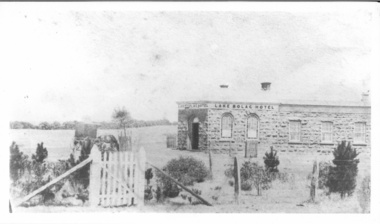 Lake Bolac & District Historical Society
Photograph - Lake Bolac Hotel 1862, Lake Bolac Hotel 1862
Lake Bolac Hotel constructed in 1862 following the establishment of a 'shanty' on the same site by James Brown in 1856. James Brown originally established a "shanty" in 1856, then built a wooden hotel and then erected the current bluestone hotel in 1862. It is made from locally quarried bluestone. In early years the hotel served the community for church services, as a barber-shop and as a morgue. -
 Sunbury Family History and Heritage Society Inc.
Photograph, Bulla Primary School, 1984
While on a school camp in Victoria's NE region, the children were taken to a number of historic sites in the area. A coloured photograph of a group of children with two adults standing in a large garden. A red-brick and rendered mansion is in the background.bulla primary school., school camps. -
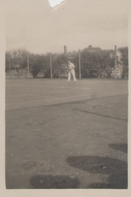 Sunbury Family History and Heritage Society Inc.
Photograph, c 1930s
The man was photographed playing tennis on the tennis courts that were sited on railway land in Evans Street Sunbury. A small snapshot of a man on a tennis court.tennis, tennis courts -
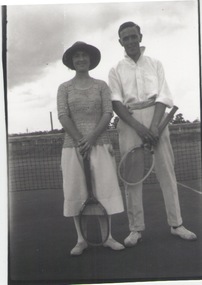 Sunbury Family History and Heritage Society Inc.
Photograph, c1920
The lady and man were standing on the tennis court which was sited in Evans Street behind the post office.A black and white photograph of a lady and man holding tennis rackets and standing in front of the net on the court.tennis, tennis courts -
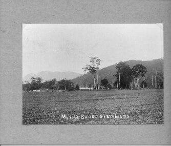 Halls Gap & Grampians Historical Society
Photograph - B/W, C 1912- 1914
Residence of Warren family overlooked by Upper Halls Gap range Site now under Lake BellfieldBuildings of Myrtlebank overlooking paddock Back drop Upper Halls GapPhoto mounted on cardboardbuildings, houses, myrtlebank -
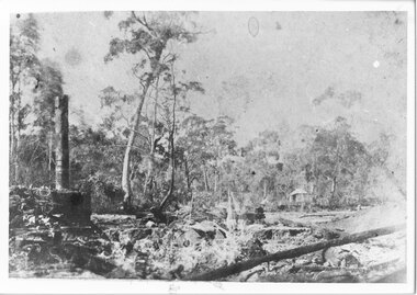 Halls Gap & Grampians Historical Society
Photograph - B/W
The photo shows the site and remains of John Child's Glenbower Mill (which operated in the mid-1800's).The photo shows a clearing with the remains of an old building and steam engine on the front left. A small hut can be seen at the back of the clearing, to the right of centretimber industries, logging, sawmilling -
 Eltham District Historical Society Inc
Document - Series Listing, Fraser Faithfull et al, Series 16: Eltham Leisure Centre Extensions 1990-1991 , industrial dispute, photographic negatives, 2000
Series consists of 26 colour negatives recording activity on the building site, including a visit by police officers.shire of eltham archives, series listing -
 Whitehorse Historical Society Inc.
Photograph, Mr. William Tilson's home, 1/06/1969 12:00:00 AM
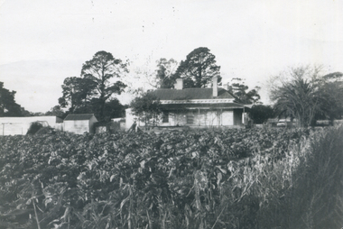
Mr William Tilson worked an orchid and market garden on this site. It was developed for housing and is known as Vermont Village.B/W photo of a cabbage garden at the home of William Tilson, on Canterbury Road, near Vermont State School.vermont state school, no. 1022, tilson, william. -
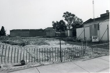 Stawell Historical Society Inc
Photograph, Vacant block site of McCracken's Garage from Main and Wimmera Streets -- Postcard -- 2 Photos
2 B/W photos of vacant block site of McCracken's Garage from Main and Wimmera Streets stawell streetscape -
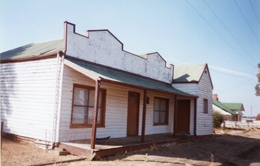 Stawell Historical Society Inc
Photograph, Rebuilt Edwards' Shop in 2004 -- rebuilt on same site by Mr Edwards' Son -- Coloured
Rebuilt Edwards Shop 2004 rebuilt on same site by Mr Edwards son. General Merchant - Lubeckstawell