Showing 4548 items matching "historical map"
-
 Stawell Historical Society Inc
Map, H C Bates Surveyor, Plan of Underground Workings. 1888, 25/8/1888
goldMagdala Co Now Moonlight Co StawellScale 80ft to an inch H C Bates Mining Surveyor 25/8/88mining -
Stawell Historical Society Inc
Map, MPI Mines, Plan View of Township Area 2003, 13/6/2003
goldShowing known gold workings & Houses Stawell Gold Mines. 13 June 2003 1 : 7500 MPI Minesmining -
Stawell Historical Society Inc
Map, MPI Mines, Plan View of Township Area 2003, 13/6/2003
goldShowing known old gold workings Stawell Gold Mines. 13 June 2003 1 : 7500 MPI Minesmining -
Stawell Historical Society Inc
Map, Northern Grampians Shire, Town of Stawell Planning Scheme, 1981
Amendment No 21 (1981) Scale 1 : 3168 ie 4 Chains = 1 inchmining, gold -
Stawell Historical Society Inc
Map, Western Mining Corp / Stawell Joint Venture, Three dimensional View of Wonga Open Cut & Decline, April 1992
Cutaway perspective showing DeclinesView Looking North West with Cut Away Showing Underground Development Floorplanmining, gold -
Stawell Historical Society Inc
Map, Stawell Gold Mine, Three dimensional View of Magdala Decline, March 1994
View of Mine looking from Stawell Hospital towards Big Hill Levels indicate depth in metres below hillParallel View Scale 1 : 2600mining, gold -
Stawell Historical Society Inc
Map, Stawell Gold Mine, Plan Showing Wonga Pit and Underground Development, August 2001
Stawell Gold Mines Victoria Scale 1 : 2500mining, gold -
Stawell Historical Society Inc
Map, Stawell Gold Mine, Tenement Boundaries Stawell Township 2001, August 2001
Showing Underground Development Stawell Gold Mines Victoria Scale 1 : 20000mining, gold -
Stawell Historical Society Inc
Map, Stawell Gold Mine, Milling Area Site Arrangement 2002, 12/6/2002
Plus Bench Mark Levels Stawell Gold Mines Victoria Scale 1 : 20000mining, gold -
Stawell Historical Society Inc
Map, Stawell Gold Mine, Perspective View Magdala Decline August 1989, August 1989
Shows Mining Levels Drawn By D. Bosher Stawell Joint Venture Victoria SJVmining, gold -
Koorie Heritage Trust
Booklet, Bremner, G.A, A Tour Brochure of Kyneton and District : with historical background, 1973
A general outline of some of the history of the area together with a map and guide to points of interest.24 p. : maps. ; 21 cm.A general outline of some of the history of the area together with a map and guide to points of interest.local history -- kyneton. -
Koorie Heritage Trust
Book, Beesley, Midge, Raymond Island : past present future, 1986
In broad terms, my approach to writing this book has been to present, firstly -- as far as is possible, a general historical background to Raymond Island and it s subsequent development since first being opened up for settlement; secondly, to record the background histories of some of the early settlers; thirdly, by featuring a number of present-day residents, to convey an image of the type of person who today chooses to become an islander and thereby becomes part of a small community that, even in 1986, is 'different'.291 p. : ill. ; index; refs.; maps; 22 cm.In broad terms, my approach to writing this book has been to present, firstly -- as far as is possible, a general historical background to Raymond Island and it s subsequent development since first being opened up for settlement; secondly, to record the background histories of some of the early settlers; thirdly, by featuring a number of present-day residents, to convey an image of the type of person who today chooses to become an islander and thereby becomes part of a small community that, even in 1986, is 'different'.urbanisation -- raymond island -- gragin ( the aboriginal name for raymond island) -- gippsland lakes, other: local history -- kurnai -- gunai. -
Koorie Heritage Trust
Book, Bowden, Keith MacRae, Goldrush doctors at Ballaarat, 1977
An historical account of events and doctors during the goldrush era at Ballarat.xiii, 125 p. : ill. (part col.), map ; 1977An historical account of events and doctors during the goldrush era at Ballarat. doctors. victoria. ballarat. gold fields, 1850-1860. | physicians -- ballarat, victoria -- history. | gold mines and mining -- victoria -- ballarat. -
Koorie Heritage Trust
Book, Osborn, Betty, The Bacchus Story : A history of Captain W. H. Bacchus of Bacchus Marsh, and his son, 1973
xi-xiv; 118 P.; maps; notes; facs.;21 cm.bacchus family. | bacchus family. victoria. bacchus marsh, 1837-1907. -
Koorie Heritage Trust
Book, Barwick, Diane et. al, Handbook for Aboriginal and Islander history, 1979
Contents: Archaeology Isabel McBryde; Archives H.J. Gibbney; Artefacts and museums Carol Cooper, Isabel McBryde; Australian Institute of Aboriginal Studies Diane Barwick, Jane Forge, James Urry; Biography: writing a life story Diane Barwick, Nan Phillips, Tom Stannage; Censuses and other population records L.R. Smith; Court and police records: evidence for Aboriginal history Tom Stannage; Genealogy: tracing family history Diane Barwick, Diane Bell, Francesca Merlan; Government - Government publications on Aborigines Brownlee Kirkpatrick; Government committees and Royal Commissions David H. Bennett. Guardians of history - Aboriginal heritage and the Australian Heritage Commission Josephine Flood; Historical Societies Nan Phillips, Tom Stannage. Land rights - Land rights: recent events and legislation Anita Campbell, Diane Bell, Diane Barwick; Land rights: an introductory bibliography Nicolas Peterson. Language: resources for research Luise Hercus, Francesca Merlan; Libraries James Urry; Maps and mapping John von Sturmer; Missions: settlements, sponsors, sources of information James Urry; Music Alice Moyle; Newspapers Andrew Markus; Oral history interviewing Peter Read; Photographic records - Koorie studies: records of the South Coast Yuin walkabout Guboo Ted Thomas; Photographs old and new Colin Roach; Films and film-making David McDougall; Publishing your work Shirley Andrew, Diane Barwick; Sport: resources for research Michael Mace, Bill Rosser; Tape recording Bryan Butler; Torres Strait Islands: information available in Papua New Guinea Peter Bolger; War and Aborigines Hank Nelson; Women in Aboriginal society: resources for research Diane Barwick, Diane Bell.xv, 187 p. ; 25 cm.Contents: Archaeology Isabel McBryde; Archives H.J. Gibbney; Artefacts and museums Carol Cooper, Isabel McBryde; Australian Institute of Aboriginal Studies Diane Barwick, Jane Forge, James Urry; Biography: writing a life story Diane Barwick, Nan Phillips, Tom Stannage; Censuses and other population records L.R. Smith; Court and police records: evidence for Aboriginal history Tom Stannage; Genealogy: tracing family history Diane Barwick, Diane Bell, Francesca Merlan; Government - Government publications on Aborigines Brownlee Kirkpatrick; Government committees and Royal Commissions David H. Bennett. Guardians of history - Aboriginal heritage and the Australian Heritage Commission Josephine Flood; Historical Societies Nan Phillips, Tom Stannage. Land rights - Land rights: recent events and legislation Anita Campbell, Diane Bell, Diane Barwick; Land rights: an introductory bibliography Nicolas Peterson. Language: resources for research Luise Hercus, Francesca Merlan; Libraries James Urry; Maps and mapping John von Sturmer; Missions: settlements, sponsors, sources of information James Urry; Music Alice Moyle; Newspapers Andrew Markus; Oral history interviewing Peter Read; Photographic records - Koorie studies: records of the South Coast Yuin walkabout Guboo Ted Thomas; Photographs old and new Colin Roach; Films and film-making David McDougall; Publishing your work Shirley Andrew, Diane Barwick; Sport: resources for research Michael Mace, Bill Rosser; Tape recording Bryan Butler; Torres Strait Islands: information available in Papua New Guinea Peter Bolger; War and Aborigines Hank Nelson; Women in Aboriginal society: resources for research Diane Barwick, Diane Bell.australian aborigines, to 1979. historical sources. | aborigines, australian -- history. | genealogy. | torres strait islanders -- history -- sources. | aboriginal australians -- genealogy. | aboriginal australians -- history -- sources. | aboriginal australians -- history. | aboriginal australians -- history -- archival resources. | aboriginal australians -- history -- library resources. | aboriginal australians -- history -- bibliography. -
Whitehorse Historical Society Inc.
Document, East Burwood reserve, 1992
History and map of East Burwood Reserve - includes details of acquisition of landHistory and map of East Burwood Reserve - includes details of acquisition of landHistory and map of East Burwood Reserve - includes details of acquisition of landcity of nunawading, east burwood reserve, burwood highway, burwood east, nos 292 - 336 -
 Whitehorse Historical Society Inc.
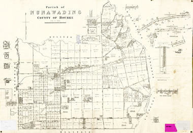
Legal record - Map, Parish of Nunawading, c1930
Office of Lands and survey map, 1864 with many further subdivisions of 1870 onwards added.Office of Lands and survey map, 1864 with many further subdivisions of 1870 onwards added. Boundaries of City of Box Hill included. Note added re Slater's land in Blackburn North. Office of Lands and survey map, 1864 with many further subdivisions of 1870 onwards added. maps, shire of blackburn and mitcham, city of box hill, slater family -
Whitehorse Historical Society Inc.
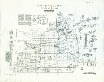
Map, Nunawading, 1972
Variation of original 1864 map with a number of additions and bold marking of an area including Forest Hill, Vermont and Vermont South as 'Proclaimed survey area No 21 May 1972 2826. Marked as P M Noting Melb SeriesVariation of original 1864 map with a number of additions and bold marking of an area including Forest Hill, Vermont and Vermont South as 'Proclaimed survey area No 21 May 1972 2826. Marked as P M Noting Melb Series.Variation of original 1864 map with a number of additions and bold marking of an area including Forest Hill, Vermont and Vermont South as 'Proclaimed survey area No 21 May 1972 2826. Marked as P M Noting Melb Seriesmaps, shire of blackburn and mitcham, forest hill, vermont, vermont south -
 Whitehorse Historical Society Inc.
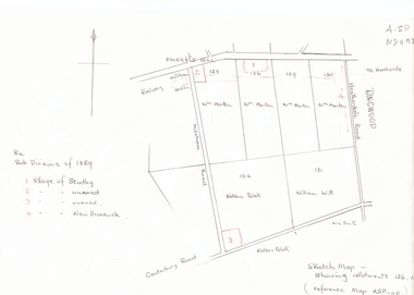
Document, Subdivisions 1859, nd
Sketch map of subdivisions of 1859.Sketch map of subdivisions of 1859. Allotment 126 and portions of 125, 126 and 130, including 'Village of Studley', 'Village of New Brunswick' and two unnamed. Information from Mr McComb, retired surveyor; sketch and notes. Areas near railway line east of Mitcham Station and North East corner of Canterbury and Mitcham Roads. Refer map A - SP 110.Sketch map of subdivisions of 1859.land subdivision, heatherdale road, mitcham, purches street, mitcham road, vermont, canterbury road, whitehorse road, brunswick road, creek road, centre road, studley village, new brunswick village -
 Whitehorse Historical Society Inc.
Map, Nunawading, 1970
Reprint of original map of Shire of NunawadingReprint of original map of Shire of Nunawading with various update but mostly showing 19th century landholders.Reprint of original map of Shire of Nunawadingmaps, shire of nunawading -
Whitehorse Historical Society Inc.
Map, Dandenong Ranges Area, 1956
Sheet 1. Parts of Parishes: Nunawading, Warrandyte and Ringwood. Scale: 10 chains : 1 inch. Contour intervals marked and locations of buildings.Sheet 1. Parts of Parishes: Nunawading, Warrandyte and Ringwood. Scale: 10 chains : 1 inch. Contour intervals marked and locations of buildings. Compiled from aerial photographs and cadastral survey information.Sheet 1. Parts of Parishes: Nunawading, Warrandyte and Ringwood. Scale: 10 chains : 1 inch. Contour intervals marked and locations of buildings. maps, ringwood, mitcham, warrandyte -
 Whitehorse Historical Society Inc.
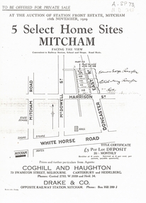
Document, 5 Select Homes Sites Mitcham, 16/11/1929 12:00:00 AM
Auction of land in Mitcham.Auction of land in Mitcham. Includes schetch map of locations and names of purchasersAuction of land in Mitcham. auction, station front estate, mitcham road, mcdowell street, doncaster east road, whitehorse road, coghill & haughton estate agents, drake & co estate agents, roeszler, norman george, edith mary, reid harrison street -
Whitehorse Historical Society Inc.
Article, 'Twin' Teaching at New School, 9/06/1976 12:00:00 AM
The new Primary School proposed at Livingstone Road, Vermont SouthThe new Primary School proposed at Livingstone Road, Vermont South, would be designed for 'closed' and 'open' teaching methods. With map.The new Primary School proposed at Livingstone Road, Vermont Southprimary schools, vermont south primary school, walton, trevor, binaisse, v., cocking, b., knight, b., newsome, m., wickenden, l., head, p. -
Whitehorse Historical Society Inc.
Map, Aerial Photographs Nunawading, 1970
State Aerial Survey, Melbourne 1970.State Aerial Survey, Melbourne 1970. Project runs 34 - 39 - City of Nunawading. Frames numbered from South to North boundaries, each strip numbered from East to West. See table of index and photo numbers attached.non-fictionState Aerial Survey, Melbourne 1970.state aerial survey, aerial photographs, nunawading, mitcham, blackburn, blackburn north, blackburn south, forest hill, vermont, burwood east, vermont south -
Whitehorse Historical Society Inc.
Map, Aerial photographs Nunawading, 1972
Department of Crown Lands and Survey, Melbourne, 1972.Department of Crown Lands and Survey, Melbourne, 1972. Project runs 34 - 39 - City of Nunawading. frames numbered from South to North boundaries, each strip numbered from West to east. The series extends further West to Box Hill and East to Ringwood than the 1970 project. No index map. Sheets 39/2 and 34/28 missing.non-fictionDepartment of Crown Lands and Survey, Melbourne, 1972.victoria. department of crown lands and survey, aerial photographs, nunawading, mitcham, blackburn, blackburn north, blackburn south, forest hill, vermont, burwood east, box hill, ringwood, vermont south -
Whitehorse Historical Society Inc.
Map, Aerial photographs Nunawading, 1976
Department of Crown Lands and Survey, Melbourne, 1976 Project.Department of Crown Lands and Survey, Melbourne, 1976 Project. Runs 29 - 33 City of Nunawading. Frames numbered from South to North boundaries, each strip numbered from West to East. No index map. Sheets 30/8 and 30/9 missing.non-fictionDepartment of Crown Lands and Survey, Melbourne, 1976 Project. victoria. department of crown lands and survey, aerial photographs, nunawading, mitcham, blackburn, blackburn north, blackburn south, forest hill, vermont, vermont south, burwood east, box hill, ringwood -
Whitehorse Historical Society Inc.
Map, M.M.B.W, c1962
Melbourne Metropolitan Area Base Map series sheet 235, covering part, Mitcham, Nunawading and Ringwood areas.Melbourne Metropolitan Area Base Map series sheet 235, covering part, Mitcham, Nunawading and Ringwood areas. Prepared by Department of Lands and Survey and Melbourne and Metropolitan Board of Works from State aerial Survey, June 1957 and Cadastral Survey information, August 1960. Scale 1:4,800.Melbourne Metropolitan Area Base Map series sheet 235, covering part, Mitcham, Nunawading and Ringwood areas. maps, mitcham, nunawading, ringwood, melbourne and metropolitan board of works, victoria. department of lands and survey -
Whitehorse Historical Society Inc.
Map, Ringwood, c1922
Victoria Ringwood Survey map 1 inch to 1 mile.Victoria Ringwood Survey map 1 inch to 1 mile. Covers Eastern suburbs of Melbourne from Richmond to Macclesfield, Heidelberg / Lilydale to Dandenong. Prepared by Commonwealth Section, Imperial General Staff.Victoria Ringwood Survey map 1 inch to 1 mile. eastern suburbs, melbourne, maps -
Whitehorse Historical Society Inc.
Map, Dandenong Ranges Area, 1955
Sheet 13. Parts of Parishes: Nunawading, Mulgrave and Scoresby.Sheet 13. Parts of Parishes: Nunawading, Mulgrave and Scoresby. Includes area of Vermont South marked as proposed Township of Norwich. Scale 10 chains : 1 inch. Contours marked.Sheet 13. Parts of Parishes: Nunawading, Mulgrave and Scoresby. maps, vermont south, wantirna, dandenong creek -
Whitehorse Historical Society Inc.
Map, Shires of Boroondara, Nunawading, C1856
Photocopy of part of very early map covering parts of Boroondara and Nunawading.Photocopy of part of very early map covering parts of Boroondara and Nunawading. Marks old tracks on lines of Whitehorse and Canterbury Roads.Photocopy of part of very early map covering parts of Boroondara and Nunawading.maps, shire of nunawading, shire of boroondara, barkers track, deep creek, nunawading