Showing 11374 items matching "land-clearing"
-
 Melbourne Athenaeum Archives
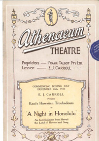
Theatre program, Syd. Day Ltd, A Night in Honolulu (Music Performance) presented by E J Carroll performed by Kaai's Hawaiian Troubadours at the Athenaeum Theatre commencing Boxing Day 26 December 1924, 1924
An Hawaiian music and dance ensemble who toured Australia at different periods 1911 - 1930Paper program for an entertainment from Hawaii the Land of Flowers and Song performed at the Athenaeum Theatre commencing Boxing Day December 26 1924; coloured cover - yellow; 16 p. includes articles about the film, the actors and advertisementsathenaeum theatre, program, programme, music theatre, a night in honolulu, frank talbot, carroll, kaai's hawaiian troubadours -
 Clunes Museum
Document - EXTRACT, CIRCA 1986
PHOTOCOPY EXTRACT FROM VICTORIAN GOVERNMENT GAZETTE PAGE 3973 NO. 86 - 15 OCTOBER 1986 REGARDING VESTING OF LAND IN THE MUNICIPALITY OF THE SHIRE OF TALBOT AND CLUNES. THAT BEING CROWN ALLOTMENT 34, SECTION C, PARISH AND TOWNSHIP OF CLUNESHANDWRITTEN IN PEN: CLU0066-01756 171/86local history, government, state government, shire of talbot and clunes -
Whitehorse Historical Society Inc.
Document, Nunawading Historical Society - Australia Day Exhibition 1988, 1/01/1988 12:00:00 AM
Australia's Bicentennial Year, by the Nunawading Historical Society.Headings and information used for a display in the Nunawading arts centre on Australia Day 1988, Australia's Bicentennial Year, by the Nunawading Historical Society. Headings: Tribal Meeting Place; Pioneers; Land Boomers and Orchardists; Between the Wars; Suburban Sprawl.Australia's Bicentennial Year, by the Nunawading Historical Society.nunawading historical society, australia day, festivals and celebrations -
Whitehorse Historical Society Inc.
Document, Certificate of Title, 1913 - 1933
Certificate of Title, Mary Elizabeth Allen of Blackburn Road, Blackburn for land, part of Crown Portion 89 at Blackburn Parish of Nunawading County of Bourke.Certificate of Title, Mary Elizabeth Allen of Blackburn Road, Blackburn for land, part of Crown Portion 89 at Blackburn Parish of Nunawading County of Bourke. Vol 3698 Fol 739579 June 19143 also correspondence on rates, 1933.Certificate of Title, Mary Elizabeth Allen of Blackburn Road, Blackburn for land, part of Crown Portion 89 at Blackburn Parish of Nunawading County of Bourke. land titles, shire of nunawading, shire of blackburn and mitcham, allen, mary elizabeth, blackburn road, blackburn -
Whitehorse Historical Society Inc.
Map, The Mascot Estate, Blackburn, 1924
Advertisement for auction of land between the railway line and Whitehorse Road in Blackburn.Advertisement for auction of land between the railway line and Whitehorse Road in Blackburn. Includes photos of houses in the neighbourhood. Auction by H. Pallyn & Co and Frank Fisher in conjunction. Street names have changed to Ceylon Street and Terracotta Drive.Advertisement for auction of land between the railway line and Whitehorse Road in Blackburn. land subdivision, whitehorse road, blackburn, simla street, mitcham, king street, blackburn, iona street, blackburn, ceylon street, blackburn, terracotta drive, blackburn, mascot estate, blackburn -
Whitehorse Historical Society Inc.
Letter - Correspondence, Mullum Mullum Creek
Letter to the Minister of Land & Works from Richard R. Cross, George Hislop, Neil Faconer (sic) and Robert Leith .Letter to the Minister of Land & Works from Richard R. Cross, George Hislop, Neil Faconer (sic) and Robert Leith regarding a track through Crown Lands which has been applied for by Messrs. Logan and Galbraith. With map.Letter to the Minister of Land & Works from Richard R. Cross, George Hislop, Neil Faconer (sic) and Robert Leith .mullum mullum creek, roads and streets, cross, richard r., hislop, george, falconer, neil, leith, robert, warrandyte mitcham track, logan, galbraith -
Whitehorse Historical Society Inc.
Book, Vermont South Community House, 1/10/1996 12:00:00 AM
Vermont South Community House : celebrating 20 years involvement in the local community, 1976 - 1996.Vermont South Community House : celebrating 20 years involvement in the local community, 1976 - 1996. Includes a brief history of Vermont South including information about the Fankhauser, Smith and Stevens Families who owned land in the area.Vermont South Community House : celebrating 20 years involvement in the local community, 1976 - 1996. vermont south community house, vermont south, fankhauser family, stevens family, smith family, vermont south community association -
Whitehorse Historical Society Inc.
Document, History of Blackburn North State School No 4715, c1970
Document re establishment of Blackburn North Primary School on 5 acres of land on the North Side of Springfield Road. Opened 5 April 1954 with initial enrolment of 237 pupils, also listing staff and school committee members.blackburn north primary school, primary schools, jenkins, p, cole, j -
 Whitehorse Historical Society Inc.
Document - Correspondence, Re A.C. Huggins, 19/10/1923 12:00:00 AM
Sworn valuation and report of A. C. HugginsSworn valuation and report of A. C. Huggins situated in Mitcham Road, Mitcham for 17 October 1923. Land of 2 acres, part under orchard (Cherry), weatherboard house of 6 rooms in fair order. Value 1,450 pounds.Sworn valuation and report of A. C. Huggins land values, huggins, a. c., mitcham road, mitcham, price, charles s. -
 Whitehorse Historical Society Inc.
Photograph, Game Family Home, C.1916
Black and white photo of Game Family Home, 18 Gordon Crescent, Blackburn. Land at side of house belonged to the property, at left was an orchard, the whole surrounded by Pines, very neglected during World War 1. C.1916.game, gladys, tom, kate -
 Whitehorse Historical Society Inc.
Letter - Document, Roads, 1/04/1868
Letter to C. Hodgkinson, Assistant Commissioner of Lands Survey from William H. Watkins, Bailiff of Crown Lands, dated 1 April 1868 re alternative locations of road through Messrs Cook or Cummings land in Nunawading.marshall's gully, cook, william, cumming (mr), watkins, william h, hodgkinson, clement, roads and streets -
 Southern Sherbrooke Historical Society Inc.
Photograph - Bagging potatoes on Hermon farm, Menzies Creek
Series of black and white photos showing workers bagging potatoes and loading onto trucks. These were taken on the Hermon farm on Black Hill Road, Menzies Creek. The Hermon family leased this land from the State Forest Commission. -
 Ballarat Tramway Museum
Photograph - Colour Print, Peter Bruce, 15/08/2015 12:00:00 AM
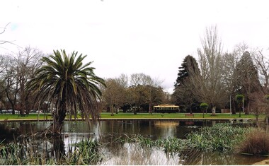
Colour print - inkjet on colour photo paper of tram 33 at Gardens Loop photographed from "fairy land" area of Lake Wendouree. Photographed by Peter Bruce on 15/8/2015 (email advice of 16-11-15).trams, tramways, lake wendouree, gardens loop, tram 33 -
 Stawell Historical Society Inc
Memorabilia - Realia, 1850-1920's
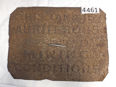
Rusted Tin Sign – "THIS LAND IS AURIFEROUS AND SUBJECT TO MINING CONDITIONS" This sign was required to be displayed in the vicinity of gold mining sites. From 1850'c to between the two world wars. Found near Rhymney Hill Great Westernc1966stawell -
 Bacchus Marsh & District Historical Society
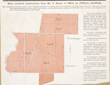
Map, Bullengarook Estate Property Sale. 1911
Bullengarook is a locality located 19 kilometers north of Bacchus Marsh. Pastoral leases for European colonists were granted to people for this area from around the 1840s.The Bullengarook Estate was part of these early pastoral holdings. By the 1900s the property had been owned by the Skene family for a number of years. In early 1911 the property then consisting of 300 acres and the homestead upon it was offered for sale in one lot. It appears however that the sale of the property did not go through in 1911. It was later leased by Thomas Skene to a Mr Coutts in 1915 and ultimately and at a later stage the property was sold by the Skene family.A single page paper map showing land allotments for sale from the Bullengarook Estate. The map is pasted into a bound volume containing 76 maps or plans in total. High resolution digital image stored on BMDHS computer network. land sales bacchus marsh, bullengarook land sales, bullengarook estate, bullengarook vic history -
University of Melbourne, Burnley Campus Archives
Newspaper - Newspaper Cutting, The Victorian Farmers Journal and Gardeners Chronicles, The Horticultural Society of Victoria, 1861
Photocopy of article in the Victorian Farmers Journal and Gardeners Chronicle 12 January, 1861 p9. Description of the Annual General Meeting of the Victorian Horticultural Society. History of applying for land for experimental and horticultural purposes and £300 grant from the Government. the victorian farmers journal and gardeners chronicle, victorian horticultural society, horticultural society of victoria, experimental garden, government grant, burnley gardens -
 Bendigo Historical Society Inc.
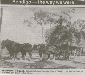
Newspaper - JENNY FOLEY COLLECTION: THE MAN ON THE LAND
BHS Collection Bendigo Advertiser '' The way we were'' from Saturday, February 28, 2004. The man on the land: George McDonnell transports hay to Bendigo from Winzar farm, on five-tonne cart drawn by five horses. The clip is in a folder.newspaper, bendigo advertiser, the way we were -
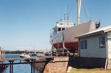 Lakes Entrance Historical Society
Photograph - Maramingo, Lakes Post Newspaper, 2000
Photo appeared in Lakes Post 12 January 2000Colour photograph of Gippsland Ports facility at Eastern Wharf. Timber fishing vessel Maramingo on slips, timber shed on land nearby, rock wall at edge of waterway, three fishing vessels in Cunninghame Arm. Lakes Entrance Victoriaships and shipping, fishing industry -
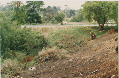
 Darebin Parklands Association
Arbour Street May 1987, Darebin Parklands Association, 1987
Colour photograph. Preparing for development of land. This item and all other Darebin Parklands Association archival material is now held by State Library Victoria (Accession No: YMS 13746). Please contact State Library Victoria if access is required.Annotated on back. -
 Darebin Parklands Association
Arbour Street 17th April 1987, Darebin Parklands Association, 1987
Colour photograph. Preparing for the development of land. This item and all other Darebin Parklands Association archival material is now held by State Library Victoria (Accession No: YMS 13746). Please contact State Library Victoria if access is required.Annotated on back. -
 Darebin Parklands Association
Arbour Street May 1987, Darebin Parklands Association, 1987
Colour photograph. Preparing for development of land. This item and all other Darebin Parklands Association archival material is now held by State Library Victoria (Accession No: YMS 13746). Please contact State Library Victoria if access is required.Annotated on back. -
 Darebin Parklands Association
Arbour Street May 1987, Darebin Parklands Association, 1987
Colour photograph. Preparing for development of land. This item and all other Darebin Parklands Association archival material is now held by State Library Victoria (Accession No: YMS 13746). Please contact State Library Victoria if access is required.Annotated on back. -
 Melbourne Tram Museum
Photograph - Black & White Photograph/s, Mark Plummer, late 1960's
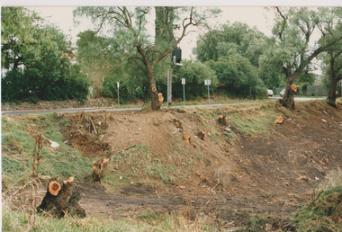
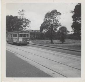
Black and white photo of W5 831, inbound route 48, Whitehorse Road or Mont Albert Road, passing a large cleared block of land. Tram has the destination of city. Photo by Mark Plummer late 1960's.Has the "Mark Plummer" stamp on the rear.trams, tramways, mmtb, mont albert, tram 831 -
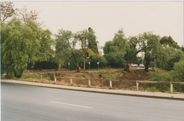
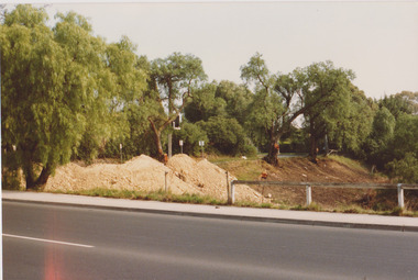
 Lakes Entrance Historical Society
Photograph, Holding M, Whiters Camp Park, 1994c
Colour copy photograph showing the cleared land which was previously part of Whiters Camp Park, in preparation for the building of a complex of attractive brick units in Roadknight Street. Estate agent's advertising signs on fence. Lakes Entrance Victoriaresort, tourism, land development -
Port Melbourne Historical & Preservation Society
Book, Gary Presland, "First People. The Eastern Kulin of Melbourne, Poprt Phillip and Central Victoria", 2010
COPYRIGHT Gary Presland "First People. The Eastern Kulin of Melbourne, Poprt Phillip and Central Victoria" This book is, in effect, a second edition of "Aboriginal Melbourne - the Lost Land of the Kulin People" written by Gary Presland 25 years earlieraustralian aborigines, environment, aborigines, kulin, gary presland -
 Ringwood and District Historical Society
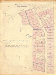
Map - Plan of Subdivision, Part of Crown Allotment 27 & 27B, Parish of Ringwood - (Undated, circa late 1950s)
Copy of land title map in manilla folder showing layout and size of 60 allotments in Railway Avenue, Victoria Street, Smithdene Avenue, Richard Court, Jeanette Court, Bruce Court and Loma Street, Ringwood East, Victoria.Note: Lot 15 is to be transferred to the Ringwood Borough Council for use as a children's playground. Map includes handwritten sales notations for several allotments, e.g. Sold. -
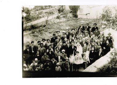 Ithacan Historical Society
Photograph, Kostopoulos wedding, Ithaca, c 1930s
The photograph is of the wedding of Telemahos and Nitsa Kostopoulos, which took place in the village of Platrithia, Ithaca in 1920s. A black and white wedding photograph of the bride and groom with the priest and altar boys surrounded by all the guests. The photograph was taken outside a cottage and in front of a wall. Cultivated land and grape vines are in the background. One man on the LHS is holding a mandolin. Written on the back in Greek: Wedding Laertes Kostopoulos and Nitsa in Platrithia 1920.kostopulos, kostos -
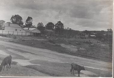 Bendigo Historical Society Inc.
Photograph - Nell Gwynne Proposed Mine Site, 1934
Significant to mining history of Bendigo.Black and white photograph of proposed mine site of Nell Gwynne Gold Mine. Image shows vacant land with weatherboard house on left hand side of image. Gravel road in foreground, two calves grazing on side of road.Written in pencil on back of photograph in black pen: 'Nell Gwynne abt 3/11/34'nell gwynne gold mine, shaft -
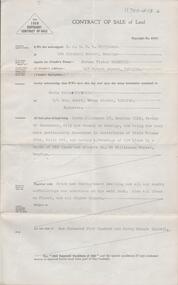
 Bendigo Historical Society Inc.
Document - H.A. & S.R. WILKINSON COLLECTION: CONDITION OF SALE
Contract of sale issued by Hyett, Willis & Hyett Solicitors and dated 30th November 1949 between the executors of W.H. Hammond Estate (seller) and G.A. Risstrom (buyer). Sale of freehold property situate at 11 Vine Street, Bendigo and all that piece of land on the western side of Vine Street about 118 links southerly from High Street with a frontage of 68 links by a depth of 80 links and a width at the rear of 31 links described in right to occupy a residence area No. 4796 in the books of the Land Department together with all improvements. Price 500 poundsorganization, business, h.a. & s.r wilkinson real estate -
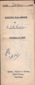
 Bendigo Historical Society Inc.
Document - H. A. & S. R. WILKINSON COLLECTION: CONTRACT OF SALE
Contract of sale of land dated 8th July, 1953 between Mr. N. V. Wodetzki (vendor) and Miss. M. C. Svanosio (purchaser). Property: Crown allotment 17 section 112C, Parish of Sandhurst, City of Bendigo being land described in certificate of title volume 6345 folio 851 and having a frontage of 100 links by a depth of 250 links and situate No. 66 Williamson Street, Bendigo, together with brick and weatherboard dwelling and all sundry outbuildings, all linos and all window blinds. Price: 1,540 pounds.organization, business, h.a. & s.r wilkinson real estate