Showing 10726 items
matching sites
-
 Bendigo Historical Society Inc.
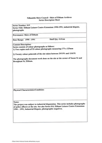
Slide - DIGGERS & MINING. DIGGERS AND MINERS, c1854
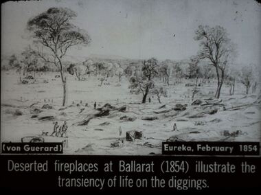
Diggers & Mining. Diggers and miners. (von Guerard) Eureka, February, 1854. Deserted fireplaces at Ballarat (1854) illustrate the transiency of life on the diggings. Slide shows old mining site with holes piles of dirt and fire places. Only a few miners are left, some appear to be leaving. Markings: 37 994:LIF I. Used as a teaching aid.hanimounteducation, tertiary, goldfields -
 Kew Historical Society Inc
Map - Subdivision Plan, Grenville Estate, 1922
Pru Sanderson, in her groundbreaking ‘City of Kew Urban Conservation Study : Volume 2 - Development History’ (1988), summarised the periods of urban development and subdivisions of land in Kew. The periods that she identified included 1845-1880, 1880-1893, 1893-1921, 1921-1933, 1933-1943, and Post-War Development. These periods were selected as they represented periods of rapid growth or decline in urban development. An obvious starting point for Sanderson’s groupings involved population growth and the associated economic cycles. These cycles also highlighted urban expansion onto land that was predominantly rural, although in other cases it represented the decline and breakup of large estates. A number of the plans in the Kew Historical Society’s collection can also be found in other collections, such as those of the State Library of Victoria and the Boroondara Library Service. A number are however unique to the collection.Subdivision plans are historically important documents used as evidence of the growth of suburbs in Australia. They frequently provide information about when the land was sold on which a built structure was subsequently constructed as well as evidence relating to surveyors and real estate and financial agents. The numerous subdivision plans in the Kew Historical Society's collection represent working documents, ranging from the initial sketches made in planning a subdivision to printed plans on which auctioneers or agents listed the prices for which individual lots were sold. In a number of cases, the reverse of a subdivision plan in the collection includes a photograph of a house that was also for sale by the agent. These photographs provide significant heritage information relating house design and decoration, fencing and household gardens.In advertising the twenty-two sites of the Grenville Estate in Cotham Road and Alfred Street, Kew, the auctioneers emphasised the proximity of the development to shops, schools, and churches. That mansions surrounded the Estate was publicised as an added attraction. The plan shows how at this stage A regrettable aspect of this plan is that it is pasted over, and obscures a real estate photograph by the Kew photographer Josiah Earl Barnes.subdivision plans - kew, grenville estate, glenferrie road, alfred street, thomas street, cotham road -
![Plan, University of Melbourne Burnley Campus Institute of Land and Food Resources Formerly known as the Royal Horticultural Gardens Burnley [sic], 2001](/media/collectors/52f2d90c9821f4163875a333/items/6145823c174069677c22f6e6/item-media/65ef8feeb2201fddf6999498/item-fit-380x285.jpg) University of Melbourne, Burnley Campus Archives
University of Melbourne, Burnley Campus ArchivesPlan, University of Melbourne Burnley Campus Institute of Land and Food Resources Formerly known as the Royal Horticultural Gardens Burnley [sic], 2001
site plan, buildings, planrs -
 Bendigo Historical Society Inc.
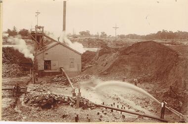
Photograph - AUSTIN COLLECTION: MINE SITE, SLUICING
BHS CollectionBlack and white photo: image shows mine site, chimney in background, corrugated iron shed in middleground, man operating sluice on bottom RH side. Men inside engine house looking on and two beside sluicing operation RH side. Large pile of sand or mullock on RH side. Mining dam in background, barely visible. Unidentified mine.bendigo, mining, mine site -
 Bendigo Historical Society Inc.
Administrative record - Opening Ceremony Details and Requisition for State School No.3893 Bendigo East
Two photocopied sheets of paper pertaining to the building of the Bendigo East State School. The first sheet is typed and dated 7th April 1916. It has details of the school committee, the attendance, the school site and cost of building the school. The second sheet is a requisition form for the erection of a wood and brick school dated 27th October 1914. Gemma Starr Collectiongemma starr collection, bendigo schools, bendigo east state school, j.w.fairbanks -
 Bendigo Historical Society Inc.
Document - BENDIGO HISTORY PERFORMING ARTS & THEATRE, 2000
Theatre History of Bendigo Paper presented by Fred Page of the Cinema and Theatre Historical Society during the Performers and Palaces Exhibition at Bendigo Bank Theatre on Friday November 24, 2000. Thanks to Bendigo Regional Archive Centre (BRAC). Reference to the building of the Lyceum theatre on the site of the Bendigo Advertiser, Pall Mall.Included is a negative of the Princess Theatre in View Street.bendigo, history, theatre history -
 Lakes Entrance Historical Society
Photograph - Maringa Creek, 1997c
Walter Seehusan, first art teacher at Bairnsdale School of Mines. Painting in possession of St Nicholas Anglican Church, Lakes Entrance, Victoria, bequeathed by Miss E L Phillips. Original painting 1890c.Colour photograph of a painting by W Seehusan of view from site of Kalimna Jetty towards Nungurner, showing mill workers cottages, jetty and steamers at Maringa Creek sawmill. Fisherman's cottage in right foreground, settlement at Maringa Creek, Gippsland Lakes, by mill workers and fishermen. Painting shows denuded cliffs and timber slide. Lakes Entrance Victoriawaterways, boats and boating, settlement -
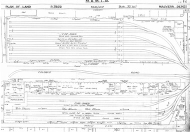 Melbourne Tram Museum
Drawing, Melbourne & Metropolitan Tramways Board (MMTB), "Malvern Depot", c1938
Set of three photocopied plans or drawings on A3 sheets of "Malvern Depot" - 15-3-1937 .1 - P7873 - Plan showing details of car sheds .2 - P7894 - Plan of Land showing overall site plan .3 - P8342 - showing details of buildings, including offices, Club Rooms in Stanhope St, No. 28 Stanhope St and sub-station.trams, tramways, drawings, depots, property, substation, malvern depot -
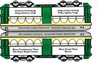 Melbourne Tram Museum
Pamphlet, Alexander Robertson, "The Cromwell Building - Auction", 2009
Pamphlet - folded and cut in the shape of a Melbourne W class tram with arched advertising windows, for the marketing of an auction of "The Cromwell Building" - Wednesday 19 August 2009 (year based on calendar search). Gives details of the building and site, and agent contact details. Has photos of the building on the corner of Elizabeth and Bourke Streets. Agents Alexander Robertson and Colliers Jardine.trams, tramways, auctions, real estate, advertisements, bourke st, elizabeth st -
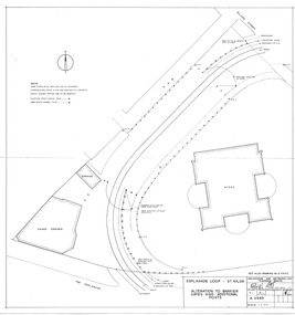 Melbourne Tram Museum
Drawing, Melbourne & Metropolitan Tramways Board (MMTB), "Esplanade loop St Kilda - Alteration to Barrier Gates and Additional Posts", Apr. 1956
Drawing - No. A3549 - titled "Esplanade loop St Kilda - Alteration to Barrier Gates and Additional Posts", shows buildings on the site, Candy corner, Kiosk, tram tracks, proposed fencing and gates, signed by Chief Engineer D Eakins on 30/4/1956. Has a hand date stamp of 7 Apr 1956 on rear noting the date printed.trams, tramways, st kilda, candy corner, turning loops -
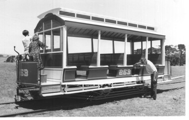 Melbourne Tram Museum
Photograph - Set of 2 Black & White Photograph/s, Keith Kings, 2/12/1979 12:00:00 AM
Set of 2 Black and White photographs of the replica Horse Tram 253 at the TMSV Bylands site. .1 - cleaning the tram - missing the end canopies .2 - Interior of the tram Notes on the rear of the tram note the work of the builder - Newton & Gillian Williams of Mildura and Alan Sutcliffe. Dated 2/12/1979. Photo Numbers 180-32 and 180-33Has the Keith Kings photo stamp on the rear, with extensive details of the photograph.trams, tramways, replica, cross bench tram, horse tram, tmsv, bylands, tram 253 -
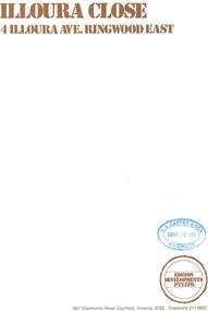 Ringwood and District Historical Society
Document - Sales Brochure, "Illoura Close" 4 Illoura Avenue, Ringwood East, Victoria. Circa 1970s
Folded brochure advertising sale of ten Group Housing Project properties, with list of features, site plan, location map, and typewritten summary of house sizes and prices. Edston Developments Pty. Ltd., 967 Glenhuntly Road Caulfield, Victoria, 3162. Telephone 211 6937. Architects: Clive Fredman and John Malina - 880 Toorak Road, East Hawthorn. Accompanying handwritten notation by Richard Carter R.E.S.I. - "Illoura Close (is) one of the few developments in Ringwood under the Cluster Titles Act". -
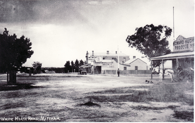 Whitehorse Historical Society Inc.
Photograph, North Corner of Whitehorse & Mitcham Road, Mitcham, c1920's
Black and white photo of the northern cnr Whitehorse and Mitcham Roads, Mitcham, showing Hughs Produce Store, with his white horse and delivery waggon outside. This was later the site of Mirama Court, later to be refurbished as shops and offices.|The vacant land on the far corner became a grocers shop and later the Westpac Bank. It is currently (2005) a computer sales shop.hughes produce store, mitcham road, mitcham, whitehorse road mitcham, mirama court mitcham, westpac bank -
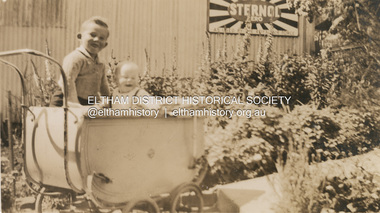 Eltham District Historical Society Inc
Photograph, Kenneth Albert Ingram and Pam Ingram (in pram) in front of house at Research next to service garage, c.1943
Kenneth Douglas Ingram's Shell service garage (in background) was located between the family home and the public hall at Research on the original line of Main Road. The public hall site is now the site of the Eltham Little Theatre. The family home (behind photographer), a red brick building still stands today (2023) at 1591 Main Road, Researchpam thoonen (nee ingram) collection, k.d. ingram shell garage, kenneth albert ingram, kenneth douglas ingram, main road, pamela lorraine ingram, research (vic.), research garage -
 Eltham District Historical Society Inc
Document - Series Listing, Fraser Faithfull et al, Series 15: Eltham Leisure Centre Extensions 1990-1991, industrial dispute, photographs, 2000
Series consists of colour photographs as follows: I) Two copies each of53 colour photographs measuring 175 x 125mm 2) Twenty colour polaroids of the site taken between 29/5/91 and 13/6/91 The photographs document work done on the site at the corner of Susan St and Brougham St, Eltham.shire of eltham archives, series listing -
 Eltham District Historical Society Inc
Slide, Construction of Eltham Town Park, 22 Feb 1974
Construction of Eltham Town Park, later renamed Alistair Knox Park. View looking across the front of Shillinglaw Cottage and what was to be developed as the Eltham Town Common (now the site of the Eltham Library) across to the Eltham Town Park development. To the right is the Eltham Trestle Bridge and to the left what was once the overflow site for the Susan Street Tip.35 mm colour positive transparency Mount - Agfacolor Service (Blue)alistair knox park, eltham town park, eltham tip, eltham town common, eltham trestle bridge -
 Federation University Historical Collection
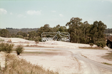
Slide, Eglise du Bras de Pontho (Church of the Holy Angels of Bras de Pontho), c1970
A small wooden chapel was built on this site but was destroyed by a cyclone in 1948. It was immediately replaced by the present church, which has simple architecture and interior ornaments. The concrete building is a large rectangle to which is added a square tower supporting a small bell tower. From the church site you can view the Bras de la Plaine valley Photograph of a church Handwritten "Eglise du Bras de Pontho" Stamped "R. Ueberschlag"eglise du bras de pontho, church of the holy angels of bras de pontho, church, bras de la plaine valley -
 Greensborough Historical Society
Photograph - Digital image, Marilyn Smith et al, Janefield Precinct: Dug in building site, 27/11/2014
Janefield Precinct: Dug in building site. The remains of this site are between Greensborough and Janefield. A RAAF Hygiene Training Camp was located on the Plenty River, just south of the Janefield community. It was in use from 1944 to 1946. The Camp was constructed from salvaged materials. Instruction included building and maintenance of grease traps, latrines, elementary plumbing and carpentry.Early remains of a WW2 training camp Digital colour photograph. -
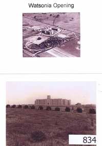 Greensborough Historical Society
Photographs, Watsonia opening; Loyola seminary. Circa 1934, 01/08/1934
The Society of Jesus (Jesuits) opened the seminary in 1934. These photographs were part of the advertising for the opening ceremony. The Jesuit Order had a presence on the site from 1934 to 1974 where a house of formation and studies for the Society of Jesus was located (the current Old Loyola building purchased by the College in 2002). Loyola College Watsonia now occupies the site.1934 photographs showing the site before the residential development in the area.Four photographs and one photocopy. Aerial and ground views.loyola college, jesuits, loyola seminary -
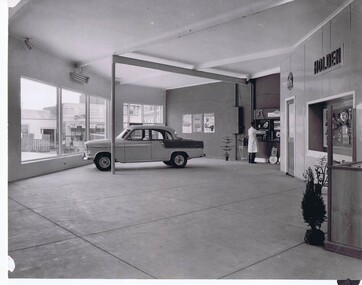 Greensborough Historical Society
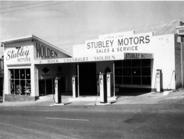
Photograph - Digital image, Stubley Holden dealership, 1960s
Stubley Holden dealership 1960s. The Stubley Group began in 1946 when Purcell Stubley purchased a site with petrol bowsers in Main Street from 'Snowy' Jessop. In 1948 Purcell began building the new Stubley Motors, working round the old site to keep the business operating. It was completed in 1951. The Group expanded into a Holden dealership in the 1960s.Digital copy of black and white photographpurcell stubley, stubley motors, stubley group greensborough -
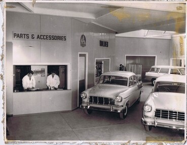 Greensborough Historical Society
Photograph - Digital image, Stubley Holden parts, 1960s
Stubley Holden dealership 1960s. The Stubley Group began in 1946 when Purcell Stubley purchased a site with petrol bowsers in Main Street from 'Snowy' Jessop. In 1948 Purcell began building the new Stubley Motors, working round the old site to keep the business operating. It was completed in 1951. The Group expanded into a Holden dealership in the 1960s.Digital copy of black and white photographpurcell stubley, stubley motors, stubley group greensborough -
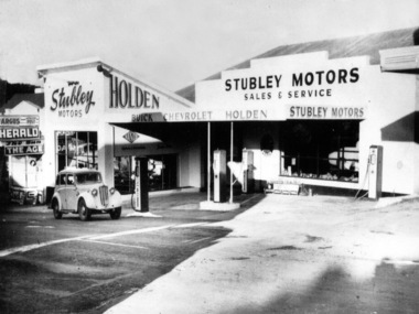 Greensborough Historical Society
Photograph - Digital image, Stubley Motors, 1950s
Stubley Motors 1950s. The Stubley Group began in 1946 when Purcell Stubley purchased a site with petrol bowsers in Main Street from 'Snowy' Jessop. In 1948 Purcell began building the new Stubley Motors, working round the old site to keep the business operating. It was completed in 1951. The Group expanded into a Holden dealership in the 1960s.Digital copy of black and white photographpurcell stubley, stubley motors, stubley group greensborough -
 Greensborough Historical Society
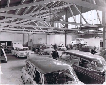
Photograph - Digital Image, Stubley Garage workshop, 1951_
Stubley Garage workshop 1951. The Stubley Group began in 1946 when Purcell Stubley purchased a site with petrol bowsers in Main Street from 'Snowy' Jessop. In 1948 Purcell began building the new Stubley Motors, working round the old site to keep the business operating. It was completed in 1951. The Group expanded into a Holden dealership in the 1960s.Digital copy of black and white photographpurcell stubley, stubley motors, stubley group greensborough -
 Orbost & District Historical Society
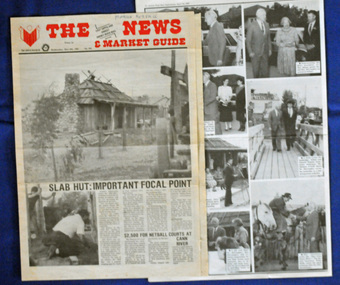
newspaper clippings, April, May 1987
The Slab Hut (Orbost Visitor Information Centre) was opened on March 28, 1987. It was officially opened by Dr D. Caughey, the governor of Victoria. The Orbost Visitor Information Centre is situated in Forest Park on Nicholson Street. The centre is housed in the historic Slab Hut. The hut was an original family dwelling built in 1872, on a site approximately three kilometres upstream from the junction of the Buchan and Snowy Rivers. The Hut was removed from its original site around 1970, and stored until 1984 when the Shire Council approved the current site. It was restored and brought to life as a Tourist Information Centre in 1987.The Slab Hut is an icon of Orbost. These newspaper articles are contemporary records of the opening of this building.A selection of articles from The News and the Snowy River Mail. All relate to the opening of the Slab Hut, the Orbost Visitor Information Centre. They are photographs, information and the history of the Slab Hut.slab-hut-orbost newspaper-snowy-river-mail -
 Bendigo Historical Society Inc.
Photograph - Victoria Hill, Bendigo, 1973
Gold was discovered on Victoria Hill in 1854 and by 1861, 1,200,000 ounces of gold had been extracted from the site. The first claim was bought for 80 pounds by Prussian immigrant Christopher Ballerstedt and his son Theodore. Christopher Ballerstedt was nicknamed the "Father of the Hill" and was the first to prove that gold reefs extended below the surface. His 200-foot plus mine shafts yielded quartz rich with gold, inspired other miners, and were instrumental in Bendigo becoming the world's deepest and richest goldfield. The site still features relics of nineteenth century mining including quartz crushing machinery and the foundations of George Lansell’s 180 mine. These features are characteristic of Bendigo’s mining history and represent two prominent nineteenth century miners, Christopher Ballerstedt and George Lansell, who held important roles in the development of Bendigo. Victoria Hill Quartz Gold Mines are registered as a site of significance. The site is of historical, archaeological and scientific importance to Victoria. The mines represent the symbolic heart of Bendigo’s gold mining history and the importance that mining played in wealth creation and the development of Victoria. The diggings reserve is accessed from the rear of Albert Richardson Reserve located at 40-56 Marong Road, Ironbark. The site has steep and unformed paths and is closed to the public at dusk. It is important to stay to the paths to avoid the diggings. Interpretive signs help visitors to appreciate the importance of the site and the remaining relics of Bendigo’s mining history.Victoria Hill Ironbark, Bendigo. Photos of the poppet head, sand heap, tailings, shafts and tunnels. Before development into a tourist attraction.history, bendigo, victoria hill, ironbark, diggings -
 Bendigo Historical Society Inc.
Photograph - Kangaroo Flat Gold Mine Collection: Catherine Reef South shaft
Kralcopic Pty Ltd, was a subsidiary of Bendigo-based company GBM Gold and had previously held mining licences around Bendigo, which incorporated sites including Kangaroo Flat, New Moon, Eaglehawk and the associated Woodvale Evaporation Ponds Complex. In August 2019, the Earth Resources Regulator decided not to renew Kralcopic’s three mining licences, due to the company’s inability to provide surety that it could finance its mining activities and site rehabilitation obligations. In October 2020, the company filed legal proceedings in the Supreme Court challenging the decision not to renew these licences. The Supreme Court later upheld the regulator’s decision not to renew the licences. On 23 April 2021, the Federal Court of Australia appointed KPMG as Kralcopic’s liquidators. On 14 May 2021, the liquidator lodged papers with the Australian Securities and Investment Commission (ASIC) to disclaim Kralcopic’s freehold land at Woodvale and parcels of land around the company’s former Bendigo sites, with the land to subsequently become Crown land. The Earth Resources Regulator has put a statutory exemption in place to preclude new mining licence applications on the sites while we undertake rehabilitation. The exemption also provides an opportunity for government to consider future uses of the sites in consultation with the City of Greater Bendigo and the local community. The Earth Resources Regulator holds rehabilitation bonds totalling $5.9 million, which it will use to rehabilitate the former sites.Colour photocopy of original photo. Image shows Catherine Reef South shaft with rectangular concrete capping. Ventilation pipe in concrete capping. On back in pencil: Catherine Reef South shaft with cap - Kralcopicwestern mining corporation, goldmining, capping, shaft, mining regulations, williams united shaft, kralcopic -
 Eltham District Historical Society Inc
Document - Series Listing, Fraser Faithfull et al, Series 16: Eltham Leisure Centre Extensions 1990-1991 , industrial dispute, photographic negatives, 2000
Series consists of 26 colour negatives recording activity on the building site, including a visit by police officers.shire of eltham archives, series listing -
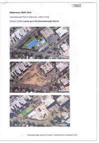 Greensborough Historical Society
Article and Photograph, Watermarc 2009-2016, 2016_
Aerial photographs of the Greensborough Pool site being redeveloped into WaterMarc (2009-2016). Images from nearmap.com.auThis text and photographs were copied from a Facebook site. Members are people who lived in the Greensborough area and share their reminiscences of the area with others. The site is administered by a GHS member but is not officially affiliated with the Society. Any information is the opinion of the contributor. Photographs and text sourced from social media.greensborough pool, watermarc -
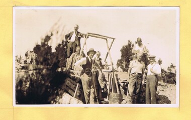 Greensborough Historical Society
Photograph - Digital Image, Mystery mine photographs: Workers at top of shaft, 1935c
This photograph shows workers at the mine site, at the top of the mine shaft. A ladder can be seen at centre of photo..An interesting collection of photographs, the connection to Greensborough remains a mystery. Digital copy of black and white photograph, one of 30 photos of mining operations. Photos have no markings or dates. Donor unknown.tasmania, mines and mining, mining machinery