Showing 4547 items matching "historical map"
-
 Whitehorse Historical Society Inc.
Map, A Plan of part of the Parish of Nunawading, 1984
Hand drawn plan showing the owners or occupiers of land c1860'.Hand drawn plan showing the owners or occupiers of land c1860'. Includes proposed townships of New Brunswick and Norwich. Scate 1 inch : 10 chains.Hand drawn plan showing the owners or occupiers of land c1860'. maps, shire of nunawading -
Whitehorse Historical Society Inc.
Map, Shire of Blackburn and Mitcham, 1928
Combination of two sheets of detailed map.Combination of two sheets of detailed map. Many subdivisions shown in details with lot numbers.Combination of two sheets of detailed map. maps, shire of blackburn and mitcham -
Whitehorse Historical Society Inc.
Map, Yarra River, 1839
Copy of T.H. Nott's original survey of 'Yarra Yarra River' taken from 'Lilydale' by Grace Aveling.Copy of T.H. Nott's original survey of 'Yarra Yarra River' taken from 'Lilydale' by Grace Aveling. Covers area from Templestowe to Yarra Glen.Copy of T.H. Nott's original survey of 'Yarra Yarra River' taken from 'Lilydale' by Grace Aveling. maps, yarra river -
Whitehorse Historical Society Inc.
Map, Aspinall's old abattoirs, Box Hill, 1937
Hand drawn plan of subdivision of old abattoirs site, Woodhouse Grove, Box Hill North.Hand drawn plan of subdivision of old abattoirs site, Woodhouse Grove, Box Hill North.Hand drawn plan of subdivision of old abattoirs site, Woodhouse Grove, Box Hill North.land subdivision, aspinall's estate, woodhouse grove, box hill north, aspinall road, box hill north, abattoirs -
Whitehorse Historical Society Inc.
Map, Nunawading Shire, 1892
Photocopy of an enlargement of map of Shire of Nunawading showing landowners in 1892.Photocopy of an enlargement of map of Shire of Nunawading showing landowners in 1892. Covers Middleborough Road to Ringwood boundary. One map (Blackburn) from north of Whitehorse Road to Highbury Road, 2nd map (Mitcham) Bulleen to south of Canterbury Road; 3rd map Whitehorse Road to Highbury Road.Photocopy of an enlargement of map of Shire of Nunawading showing landowners in 1892. maps, shire of nunawading, blackburn, blackburn south, nunawading, forest hill, vermont, mitcham, vermont south -
 Whitehorse Historical Society Inc.
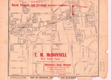
Document, T. M. McDonnell, 1929
Correspondence of T.M. McDonnellCorrespondence of T.M. McDonnell dated 16 October 1929, typed on headed stationery with a 'map of Mitcham, Tunstall and Blackburn'.Correspondence of T.M. McDonnell mcdonnell, t.m., mitcham, nunawading, blackburn, forest hill, vermont -
 Whitehorse Historical Society Inc.
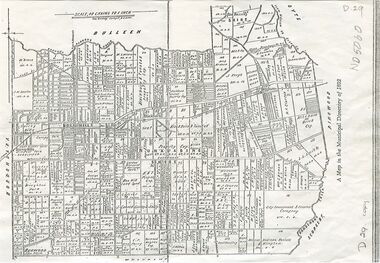
Map, Shire of Nunawading, 1892
Map of the Shire of Nunawading in the Municipal Directory of 1892e of NunawadingPhotocopy of a map of the Shirew of Nunawading in the Municipal Directory of 1892 showing land owners.Map of the Shire of Nunawading in the Municipal Directory of 1892e of Nunawadingmaps, shire of nunawading -
Whitehorse Historical Society Inc.
Map, Nunawading. County of Bourke, 1878
Photocopy of map of Shire of Nunawading.Photocopy of map of Shire of Nunawading. Note: Fosters v President of the Shire of Nunawading. On Verso: Copied from the most up to date by the Dept of Lands, 1878. Laid before the Executive Council, 11 June 1878. Shows land holders.Photocopy of map of Shire of Nunawading.shire of nunawading, maps -
Whitehorse Historical Society Inc.
Map, Map 1892. Nunawading Shire, 1892
Duplicated same as ND5060 Map of Shire of Nunawading.Duplicated same as ND5060 Map of Shire of Nunawading. Shows railway line including spur from Box Hill to Box Hill Brick Co.Duplicated same as ND5060 Map of Shire of Nunawading. maps, shire of nunawading, railways, box hill brick company -
Whitehorse Historical Society Inc.
Map, Map of Vermont area, c1895
Photocopy of part of a larger map showing the Vermont area.Photocopy of part of a larger map showing the Vermont area. Note on side 'after 1892'. Shows land holders.Photocopy of part of a larger map showing the Vermont area.maps, vermont -
 Whitehorse Historical Society Inc.
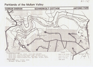
Pamphlet, Parklands of the Mullum Valley, 1998
recreation areas of the Mullum ValleyLeaflet of introduction to the parks and recreation areas of the Mullum Valley including a map of the area. recreation areas of the Mullum Valleyparks and reserves, yarran dheran, schwerkolt cottage, antonio park, mitcham, mullum mullum creek -
Whitehorse Historical Society Inc.
Pamphlet, Tour of Nunawading, 1970s?
Guide, starting at the Civic Centre and stating places of interest. With a cardboard map with numbers.Guide, starting at the Civic Centre and stating places of interest. With a cardboard map with numbers.Guide, starting at the Civic Centre and stating places of interest. With a cardboard map with numbers.city of nunawading, civic centre -
Whitehorse Historical Society Inc.
Article, Tour of City of Nunawading, 1968?
Notes for a tour of the City of Nunawading, with accompanying map.Notes for a tour of the City of Nunawading, with accompanying map.Notes for a tour of the City of Nunawading, with accompanying map.city of nunawading, map -
Whitehorse Historical Society Inc.
Pamphlet, Short History of Nunawading, 1992
Short history of Nunawading, including photos and maps, compiled by the Nunawading Historical Society Inc.Short history of Nunawading, including photos and maps, compiled by the Nunawading Historical Society Inc. Reprinted 1992, with some additional material.Short history of Nunawading, including photos and maps, compiled by the Nunawading Historical Society Inc.nunawading, historical society -
Whitehorse Historical Society Inc.
Document, Vermont pre 1890, 1985?
Short history of Vermont, pre 1890. Nunawading Historical Society competition, first prize, open section. With maps and photographs.Short history of Vermont, pre 1890. Nunawading Historical Society competition, first prize, open section. With maps and photographs.Short history of Vermont, pre 1890. Nunawading Historical Society competition, first prize, open section. With maps and photographs.vermont, nunawading -
 Whitehorse Historical Society Inc.
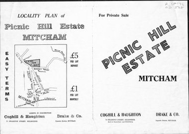
Pamphlet, Picnic Hill Estate, Mitcham, n.d
Photocopy of pamphlet, locality map and plan of 40 home sites on Picnic Hill estate extending from Quarry Road, Mitcham Road and McKeon Road, Mitchamland subdivision, mitcham road, mitcham, quarry road, mckeon road, wooddale grove, rotherwood avenue, cobham road -
Whitehorse Historical Society Inc.
Map, Melbourne and Metropolitan Board of Works, 1925
1925 plan of the Yan Yean, Maroondah and O'Shannassy water supply systems.1925 plan of the Yan Yean, Maroondah and O'Shannassy water supply systems.1925 plan of the Yan Yean, Maroondah and O'Shannassy water supply systems.water supply, melbourne and metropolitan board of works -
Whitehorse Historical Society Inc.
Map, Eastern Freeway Extension, 2002
Extension of Eastern Freeway: Plan of Deep Creek Road paths, drainage and alignment plan.Extension of Eastern Freeway: Plan of Deep Creek Road paths, drainage and alignment plan.Extension of Eastern Freeway: Plan of Deep Creek Road paths, drainage and alignment plan.deep creek road, mitcham, eastern freeway extension, eastlink -
Whitehorse Historical Society Inc.
Document, What happened to Norwich?
Norwich, consisting of 475 acres in the Parish of Nunawading, County of Bourke, found on a land sale map in the La Trobe collection of Vale maps.Norwich, consisting of 475 acres in the Parish of Nunawading, County of Bourke, found on a land sale map in the La Trobe collection of Vale maps. Research by Jean Uhl into the fate of the proposed township.Norwich, consisting of 475 acres in the Parish of Nunawading, County of Bourke, found on a land sale map in the La Trobe collection of Vale maps. local history, uhl, jean, parish of nunawading, norwich village, vermont, lobb, john, graham, thomas -
Whitehorse Historical Society Inc.
Book, The orchards of Doncaster Templestowe, 1985
Detailed history of fruit growing in the area with photos and maps.Detailed history of fruit growing in the area with photos and maps.Detailed history of fruit growing in the area with photos and maps.orchards, doncaster -
Whitehorse Historical Society Inc.
Document, Kelly Gang Film, 1994
Manuscript notes with typed copy. The 'Kelly Gang' film at 1320ft long which ran for over an hour is longer than the film 'The Great Train Robbery' (1903) claimed as the first full length picture made in the world.Manuscript notes with typed copy. The 'Kelly Gang' film at 1320ft long which ran for over an hour is longer than the film 'The Great Train Robbery' (1903) claimed as the first full length picture made in the world. 'Lowberry' timber house owned by McDonnells (with sketch map)Manuscript notes with typed copy. The 'Kelly Gang' film at 1320ft long which ran for over an hour is longer than the film 'The Great Train Robbery' (1903) claimed as the first full length picture made in the world. mcdonnell family, the story of the kelly gang (film), films -
Whitehorse Historical Society Inc.
Report, Charles William Gilbert Blake, 1/06/1997
Photocopy of school assignment. Includes information about a number of local war memorials and an investigation of Charles William Gilbert Blake whose name is on the Mitcham War Memorials. Blake enlisted in East Burwood. He trained in Egypt and was then sent to England where he died in hospital of an abscess in the brain. He is buried at the Tidworth Military Cemetery. Photographs. Maps. Approx 28 pagesblake, charles william gilbert, war memorials, world war, 1914 - 1918, tidworth military cemetery -
Whitehorse Historical Society Inc.
Document, My memories of the area around Simpson Park, 1/10/2003 12:00:00 AM
Memories with promptings from Jack Leach who lived in Rupert Street and later in Creek Road.Memories with promptings from Jack Leach who lived in Rupert Street and later in Creek Road. Describes that part of Mitcham south of the railway line between Creek Road and Cochrane street. A sketch map of the area as it was in the 1930's is also supplied.Memories with promptings from Jack Leach who lived in Rupert Street and later in Creek Road.brunswick road, mitcham, creek road, mitcham, cochrane street, mitcham, rupert street, mitcham, bloom family, leach, jack, leach family, simpson family, ferris, ray, simpson park -
Whitehorse Historical Society Inc.
Map, Schwerkolt property, 1/10/2003 12:00:00 AM
A reworking by Ted Arrowsmith of Arthur Schwerkolt's plan of the Schwerkolt property as it was in the 1930's.A reworking by Ted Arrowsmith of Arthur Schwerkolt's plan of the Schwerkolt property as it was in the 1930's.A reworking by Ted Arrowsmith of Arthur Schwerkolt's plan of the Schwerkolt property as it was in the 1930's.schwerkolt cottage, schwerkolt, arthur -
Whitehorse Historical Society Inc.
Pamphlet, Heritage Walk
Pamphlet describing a walk around Blackburn Lake and giving some of the history of the lake and its surrounding area. Includes map.Pamphlet describing a walk around Blackburn Lake and giving some of the history of the lake and its surrounding area. Includes map.Pamphlet describing a walk around Blackburn Lake and giving some of the history of the lake and its surrounding area. Includes map.blackburn lake, adult deaf and dumb society, lake park, flower growing, heidelberg school -
Whitehorse Historical Society Inc.
Pamphlet, Blackburn Lake Sanctuary, c2000
Description of the Blackburn Lake Sanctuary with a brief history, information about events held in the sanctuary and the role of the Blackburn Lake sanctuary Advisory Committee. Detailed map.Description of the Blackburn Lake Sanctuary with a brief history, information about events held in the sanctuary and the role of the Blackburn Lake sanctuary Advisory Committee. Detailed map.Description of the Blackburn Lake Sanctuary with a brief history, information about events held in the sanctuary and the role of the Blackburn Lake sanctuary Advisory Committee. Detailed map.blackburn lake, blackburn lake sanctuary advisory committee -
Whitehorse Historical Society Inc.
Document, Gordon Hildesley Neve, 3/10/1975 12:00:00 AM
Letter, 3 Oct 1975 from Mr Neve and copy of 1858 agreement with Box Hill Council relating to connection of electricity to his home at 39 Wattle Valley Road Mitcham,Letter, 3 Oct 1975 from Mr Neve and copy of 1858 agreement with Box Hill Council relating to connection of electricity to his home at 39 Wattle Valley Road Mitcham, later (1975) 12 Nara Road. With map.Letter, 3 Oct 1975 from Mr Neve and copy of 1858 agreement with Box Hill Council relating to connection of electricity to his home at 39 Wattle Valley Road Mitcham,electricity supply, neve, gordon hildesley, city of box hill, mitcham, wattle valley road, nara road, cook street, burnett street, sharrow road -
Whitehorse Historical Society Inc.
Pamphlet, Bellbird Dell
A pamphlet about a municipal reserve - Bellbird Dell, with a list of names of the Management Committee.A pamphlet about a municipal reserve - Bellbird Dell, with a list of names of the Management Committee. Also states they are looking for helpers for regular working bees. Includes map of reserve.A pamphlet about a municipal reserve - Bellbird Dell, with a list of names of the Management Committee.local government, city of nunawading, bellbird dell, vermont -
Whitehorse Historical Society Inc.
Map, Boronia Road, Vermont, 1970
Enlargement of aerial photograph of Boronia Road, Vermont. State Aerial Survey 1970 Run 37Enlargement of aerial photograph of Boronia Road, Vermont. State Aerial Survey 1970 Run 37Enlargement of aerial photograph of Boronia Road, Vermont. State Aerial Survey 1970 Run 37boronia road, vermont, lusk drive, vermont, morack road, vermont south, allison court, vermont, trinian street, vermont, cosgrove street, vermont, mawson court, vermont, aerial photographs -
Whitehorse Historical Society Inc.
Map, Boronia Road, Vermont, 1970
Enlargement of Aerial photograph of Boronia Road Vermont, State Aerial Survey, 1970. Run 37Enlargement of Aerial photograph of Boronia Road Vermont, State Aerial Survey, 1970. Run 37Enlargement of Aerial photograph of Boronia Road Vermont, State Aerial Survey, 1970. Run 37boronia road, vermont, gallus close, vermont, moore road, vermont, carlinga drive, vermont, beleura avenue, vermont, olinda crescent, vermont, penllyne avenue, vermont, holyrood drive, vermont, aerial photographs