Showing 10728 items
matching sites
-
 Greensborough Historical Society
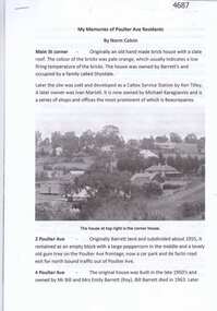
Article, Norm Colvin, My memories of Poulter Ave residents, by Norm Colvin, 28/07/2016
Details of the development and occupation of sites in Poulter Avenue and Bicton Street Greensborough, compiled by resident Norm Colvin.12 pages, text, black and white photographs and colour subdivision plan.poulter avenue greensborough, bicton street greensborough -
 Greensborough Historical Society
Photograph - Digital image, John Gibson et al, Luxford home in Main Street, 1950s
The Luxford home in Main Street Greensborough, rented from Mr Jessop. Chemist Warehouse is now on this site.Digital copy of black and white photograph. luxford family, main street greensborough, cecil jessop -
 Halls Gap & Grampians Historical Society
Photograph - B/W, C 1912- 1914
Residence of Warren family overlooked by Upper Halls Gap range Site now under Lake BellfieldBuildings of Myrtlebank overlooking paddock Back drop Upper Halls GapPhoto mounted on cardboardbuildings, houses, myrtlebank -
 Halls Gap & Grampians Historical Society
Photograph - B/W
The photo shows the site and remains of John Child's Glenbower Mill (which operated in the mid-1800's).The photo shows a clearing with the remains of an old building and steam engine on the front left. A small hut can be seen at the back of the clearing, to the right of centretimber industries, logging, sawmilling -
 Federation University Historical Collection
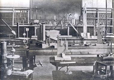
Photograph, Ballarat School of Mines Physics Laboratory, c1908
The Ballarat School of Mines was the first site of Technical Education in Australia. Initially it opened in 1870 and educated miners. Black and white photograph of the interior of the Ballarat School of Mines Physics Laboratory. Numerous pieces of equipment sit on benches. The image in the 1908 Ballarat School of Mines Calendar was title 'Physics Demonstration Room'.ballarat school of mines, laboratory, physics, scientific instruments, science, classroom, education -
 Yarra City Council
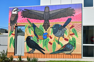
Artwork, other - Mural, Rebecca Atkinson, Queep Queep, 2023
'Queep-Queep’ means ‘birds’ in Woi-wurrung language—the language of the Wurundjeri people—the Traditional Owners of the land on which the building is standing. Referencing what lived and flourished in this area prior to European invasion, the artwork acknowledges the important Aboriginal history of the area now known as the City of Yarra. The six native birds depicted in the artwork can all be found living within the City of Yarra: the male red-rumped parrot, kookaburra, superb fairy wren, rainbow lorikeet, raven, and wedge-tailed eagle. Many south-eastern Aboriginal people recognise the wedge-tailed eagle as Bunjil—the creator spirit. Bunjil is the head of the Kulin Nation and is very powerful. Bunjil created the land, waterways, animals, plants and even the people. He is watching over the land to ensure that we are caring for Country—reminding us to respect ourselves, respect others and respect the environment.'Queep-Queep' is a site-specific artwork commissioned for the new Richmond Kindergarten, Lord Street, Richmond, 2023.Two aluminium birds (a wedge-tailed eagle and a raven) at the entrance to the building, and a large, colourful mural of Australian native birds painted in a graphic style on the other side of the wall facing into the playground.accompanying plaquebirds, bunjil, country, kulin nation, environment, public art -
 Tatura Irrigation & Wartime Camps Museum
Photograph, Arthur Knee, 1989
Camp 13, concrete pit, rolled barbed wire, near site of Camp 13 administration area.Camp 13, Camp Road, Murchison, Victoria. Concrete pit and tangled barbed wire.camp 13, murchison victoria, pow, internment camp -
Tatura Irrigation & Wartime Camps Museum
Architect plans, Tatura Methodist Church, 1964
Methodist Church was built and opened on present site (Uniting) in 1959. These extensions completed the building as it now stands.1 of 2 copies (L3264) of complete architects plans and specifications for extensions to Tatura Methodist Church building, 1964. methodist church tatura, alexander harris & assoc. -
Tatura Irrigation & Wartime Camps Museum
Architect plans, Tatura Methodist Church, 1964
Methodist Church was built and opened on present site (Uniting) in 1959. These extensions completed the building as it now stands.1 of 2 copies (L3263) of complete architects plans and specifications for extensions to Tatura Methodist Church building, 1964. methodist church tatura, alexander harris & assoc. -
 Lake Bolac & District Historical Society
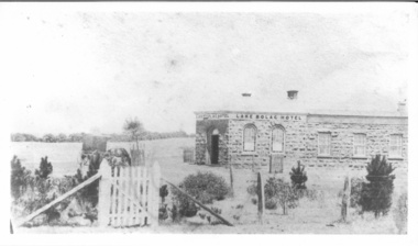
Photograph - Lake Bolac Hotel 1862, Lake Bolac Hotel 1862
Lake Bolac Hotel constructed in 1862 following the establishment of a 'shanty' on the same site by James Brown in 1856. James Brown originally established a "shanty" in 1856, then built a wooden hotel and then erected the current bluestone hotel in 1862. It is made from locally quarried bluestone. In early years the hotel served the community for church services, as a barber-shop and as a morgue. -
 Robin Boyd Foundation
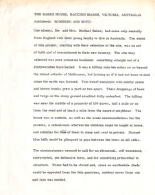
Document - Manuscript, Robin Boyd, The Baker House, Bacchus Marsh, Victoria, Australia, 1966
Description of Baker family, site and house. Choice of slate building material, water tanks and arrangement of spaces.Published as 'Baker House, Bacchus Marsh, Victoria: Architects - Romberg and Boyd' in "World Architecture 3", edited by John Donat (1966).Typewritten, quarto, 2 pagesPencil annotationsbaker family, baker house, bacchus marsh, slate, water tanks, residential architecture, site analysis, robin boyd, manuscript -
 Robin Boyd Foundation
Document - Manuscript, Robin Boyd, Tokyo Cathedral, c. 1965
A detailed critique of Kenzo Tange's St Mary's Cathedral, Tokyo and experience of visiting the site. (later published asPublished as "A Cruciform Window onto Heaven" in "Architectural Forum", vol. 123, no. 2, September 1965, pp. 50-55.Typewritten (c copy), foolscap, 4 pages. (Three copies)st mary's cathedral, tokyo, kenzo tange, hiroshima, tokyo olympic games, hyperbolic paraboloid, japan, robin boyd, manuscript -
 Whitehorse Historical Society Inc.
Photograph, Mr. William Tilson's home, 1/06/1969 12:00:00 AM
Mr William Tilson worked an orchid and market garden on this site. It was developed for housing and is known as Vermont Village.B/W photo of a cabbage garden at the home of William Tilson, on Canterbury Road, near Vermont State School.vermont state school, no. 1022, tilson, william. -
 Sunbury Family History and Heritage Society Inc.
Photograph, Bulla Primary School, 1984
While on a school camp in Victoria's NE region, the children were taken to a number of historic sites in the area. A coloured photograph of a group of children with two adults standing in a large garden. A red-brick and rendered mansion is in the background.bulla primary school., school camps. -
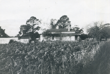
 Sunbury Family History and Heritage Society Inc.
Photograph, c1920
The lady and man were standing on the tennis court which was sited in Evans Street behind the post office.A black and white photograph of a lady and man holding tennis rackets and standing in front of the net on the court.tennis, tennis courts -
 Stawell Historical Society Inc
Photograph, Vacant block site of McCracken's Garage from Main and Wimmera Streets -- Postcard -- 2 Photos
2 B/W photos of vacant block site of McCracken's Garage from Main and Wimmera Streets stawell streetscape -
 Stawell Historical Society Inc
Photograph, New Hospital under construction on the St George Sand Dump looking from Sloane Street
View from Sloane Street of St George Sand Dump site with New Hospital under construction.stawell hospital -
 Stawell Historical Society Inc
Photograph, Rebuilt Edwards' Shop in 2004 -- rebuilt on same site by Mr Edwards' Son -- Coloured
Rebuilt Edwards Shop 2004 rebuilt on same site by Mr Edwards son. General Merchant - Lubeckstawell -
 Stawell Historical Society Inc
Photograph, Hall’s Gap Tourist Promotion Officer Mr Ian R. McCann in the centre studing Pool Plans 1970
Group at Pool Site with Plans. Hall’s Gap Tourist Promotion Officer I.R. McCann at centre 1970stawell -
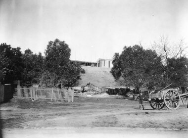
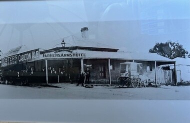 Greensborough Historical Society
Photograph - Photograph (Framed), Monaghan's Farmers Arms Hotel corner Hailes and Main Streets Greensborough, 1890s
Monaghan's Farmers Arms Hotel cnr Hailes and Main Streets Greensborough. This was the site of the new Greensborough Hotel.From the John Mackey collection. this item was displayed at the offices of Ryan, Mackey and Kelly, solicitors, Main Street Greensborough.Timber-framed photograph of Hotel, black and white.greensborough, john mackey, farmers arms hotel -
 Lakes Entrance Historical Society
Photograph - Historic House, 1999
Building reputed to be part of Mrs Carstairs Boarding House at New Works, dismantled and transported to present site.Colour photograph of a timber dwelling at 12 Hunter Street. With hip roof across building, gable at right angles at western.front room. Iron roof, bull nose veranda. Simple timber fringe under veranda roof, timber brackets connect fringe to square veranda posts with lathed pattern in centre. Lakes Entrance Victoriahouses, heritage study -
 Lakes Entrance Historical Society
Photograph - Historic House, 2000
Possibly relocated from another site (local information). Home of Berlingeri family since 1960's.Colour photograph of a dwelling at 8 Roadknight Street, with corrugated iron hipped roof. Timber walls, original veranda on front and side have been enclosed. Outer walls covered with cladding. Lakes Entrance Victoriahouses, heritage study -
 Bendigo Historical Society Inc.
Photograph - Victoria Hill, Bendigo, 1973
Gold was discovered on Victoria Hill in 1854 and by 1861, 1,200,000 ounces of gold had been extracted from the site. The first claim was bought for 80 pounds by Prussian immigrant Christopher Ballerstedt and his son Theodore. Christopher Ballerstedt was nicknamed the "Father of the Hill" and was the first to prove that gold reefs extended below the surface. His 200-foot plus mine shafts yielded quartz rich with gold, inspired other miners, and were instrumental in Bendigo becoming the world's deepest and richest goldfield. The site still features relics of nineteenth century mining including quartz crushing machinery and the foundations of George Lansell’s 180 mine. These features are characteristic of Bendigo’s mining history and represent two prominent nineteenth century miners, Christopher Ballerstedt and George Lansell, who held important roles in the development of Bendigo. Victoria Hill Quartz Gold Mines are registered as a site of significance. The site is of historical, archaeological and scientific importance to Victoria. The mines represent the symbolic heart of Bendigo’s gold mining history and the importance that mining played in wealth creation and the development of Victoria. The diggings reserve is accessed from the rear of Albert Richardson Reserve located at 40-56 Marong Road, Ironbark. The site has steep and unformed paths and is closed to the public at dusk. It is important to stay to the paths to avoid the diggings. Interpretive signs help visitors to appreciate the importance of the site and the remaining relics of Bendigo’s mining history.Victoria Hill Ironbark, Bendigo. Photos of the poppet head, sand heap, tailings, shafts and tunnels. Before development into a tourist attraction.history, bendigo, victoria hill, ironbark, diggings -
 Bendigo Historical Society Inc.
Photograph - Kangaroo Flat Gold Mine Collection: Catherine Reef South shaft
Kralcopic Pty Ltd, was a subsidiary of Bendigo-based company GBM Gold and had previously held mining licences around Bendigo, which incorporated sites including Kangaroo Flat, New Moon, Eaglehawk and the associated Woodvale Evaporation Ponds Complex. In August 2019, the Earth Resources Regulator decided not to renew Kralcopic’s three mining licences, due to the company’s inability to provide surety that it could finance its mining activities and site rehabilitation obligations. In October 2020, the company filed legal proceedings in the Supreme Court challenging the decision not to renew these licences. The Supreme Court later upheld the regulator’s decision not to renew the licences. On 23 April 2021, the Federal Court of Australia appointed KPMG as Kralcopic’s liquidators. On 14 May 2021, the liquidator lodged papers with the Australian Securities and Investment Commission (ASIC) to disclaim Kralcopic’s freehold land at Woodvale and parcels of land around the company’s former Bendigo sites, with the land to subsequently become Crown land. The Earth Resources Regulator has put a statutory exemption in place to preclude new mining licence applications on the sites while we undertake rehabilitation. The exemption also provides an opportunity for government to consider future uses of the sites in consultation with the City of Greater Bendigo and the local community. The Earth Resources Regulator holds rehabilitation bonds totalling $5.9 million, which it will use to rehabilitate the former sites.Colour photocopy of original photo. Image shows Catherine Reef South shaft with rectangular concrete capping. Ventilation pipe in concrete capping. On back in pencil: Catherine Reef South shaft with cap - Kralcopicwestern mining corporation, goldmining, capping, shaft, mining regulations, williams united shaft, kralcopic -
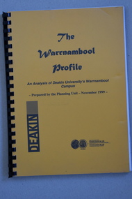 Warrnambool and District Historical Society Inc.
Booklet Lettering Book, Deakin University Planning Unit, The Warrnambool Profile – An Analysis of Deakin University’s Warrnambool Campus, 1999
This booklet was prepared in 1999 by the Planning Unit of Deakin University. It gives current data on the campus and projections and suggestions for the future. The Warrnambool Campus of Deakin University was established in 1990 after a merger with the Warrnambool Institute of Advanced Education which was already on the site that the university still occupies. This is Sherwood Park, a 94 hectare site on the Princes Highway, five kilometres from Warrnambool.This booklet is of some interest as it contains information on the Warrnambool Campus of Deakin University ten years after it was first established. This is a soft cover booklet of 179 pages. It has an orange front cover and a black back cover with black printing and a plastic over-sheet. The booklet has printed information, tables and graphs. It has black plastic spiral binding. deakin university, warrnambool campus -
Glen Eira Historical Society
Map - Caulfield Fire Station, No 26, Tree Reserve, Dandenong Road
A one page photocopy of an undated, unattributed, hand drawn map (200mm x 290mm) of the location on Tree Reserve, Dandenong Road, of the Caulfield Fire station, No 26. The map includes handwritten notes showing various nearby property owners. The file also includes a photocopy of a one page, undated and unattributed printout of the site address and site lease date.caulfield east, caulfield fire station, dandenong road, derby road, racecourse road, tree reserve, shire of caulfield, federal bank, st james building society, delves murchison, fire stations -
 Phillip Island and District Historical Society Inc.
Photographs, Isle of Wight Hotel Fire, 2010
A4 colour prints of photographs taken after the fire. The first Isle of Wight Hotel was built in c 1870. It burnt down in 1925 and was rebuilt. The hotel was sold and was to be demolished for a new hotel to be built on the site, however before this could take place it burnt down again on the 22nd May, 2010. The site is still vacant (28/9/2016). Five coloured photographs of the Isle of Wight Hotel fire in 2010 at Cowes, Phillip Island. Photographs depict front views, side views and rear view of the hotel after the fire.isle of wight hotel fire, hotels cowes phillip island, lisa schonberg -
 Greensborough Historical Society
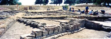
Photograph - Photograph Collection, Jan Macdonald, Viewbank Homestead archaeological excavation 1999, 1999
In 1999, an archaeological dig was undertaken at the Viewbank Homestead site in Viewbank. This set of photographs was taken at the dig site in 1999. The house was built c1840 by James Williamson; it was later purchased by George Gear as a wedding gift to his daughter on her marriage to Dr Robert Martin. It became a grand mansion in the late 1800s but by the 1920s, it was stripped bare of materials and demolished in the 1920s. The archaeological dig was and insight into early life in the Viewbank HomesteadSet of 8 panoramic photos of archaeological dig and flyer for dig.viewbank homestead, banyule road viewbank, viewbank, archaeological digs -
 Greensborough Historical Society
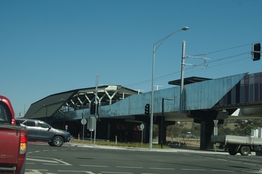
Photograph - Digital Image, Marilyn Smith, Mernda Station 2018, 27/09/2018
In 2018 GHS members visited Turner's Bakery in Mernda for lunch and continued on to visit historic sites remaining in the Mernda area. This photograph shows the newly built Mernda Station, part of the railway extension on the old Epping line. This station was opened in August 2018. Mernda is now the end of the line. It is sited on corner Bridge Inn Road and Schotters Road. Mernda is an area of rapid modern growth with a few remaining historic buildings dating from the 19th century.Digital copy of colour photographmernda, mernda historic sites, schotters road mernda, mernda station, bridge inn road mernda -
 Greensborough Historical Society
Photograph - Digital Image, Stubley News and History, 1954_03
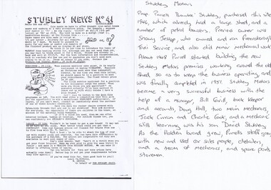
Stubley Motors Newsletter March 1954. The Stubley Group began in 1946 when Purcell Stubley purchased a site with petrol bowsers in Main Street from 'Snowy' Jessop. In 1948 Purcell began building the new Stubley Motors, working round the old site to keep the business operating. It was completed in 1951. The Group expanded into a Holden dealership in the 1960s.Digital copy of black and white newsletter, with handwritten notes on the company's history.purcell stubley, stubley motors, stubley group greensborough