Showing 2976 items matching " bendigo mines"
-
 Bendigo Historical Society Inc.
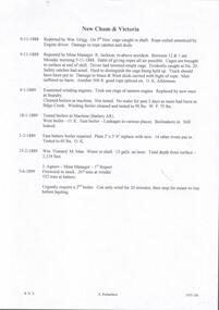
Document - NEW CHUM & VICTORIA - NEW CHUM & VICTORIA MINE MANAGERS REPORTS
Handwritten copies from New Chum & Victoria Mine Managers Reports. 9/11/1888 Cage caught in shaft reported by Wm Grigg. 9/11/1888 More about the cage being caught, reported by Mine manager R Jackson. 4/1/1889 Replaced rings in eastern winding engine. No water for 2 days as main burst at Bendigo Creek. 18/1/1889 East boiler leaking. Boilermakers in. Still leaked. 1/2/1889 East battery repaired. 15/2/1889 Water in shaft 15 galls an hour. Total depth from surface 2,134 feet. Wm Vinnard. M. Man. 7/6/1899 Firewood in stock, at ?indes, 552 tons at battery. Urgently require a 2nd boiler. Can only wind for 20 minutes, then stop for steam to rise before hauling. J Agnew Mine Manager.document, gold, new chum & victoria, new chum & victoria mine managers reports, wm grigg, r jackson, wm vinnard, j agnew -
 Bendigo Historical Society Inc.
Document - LITTLE 180 MINE - NOTES ON THE LITTLE 180 MINE
... Mines Dept Booklet Bendigo Goldfield 1936... Booklet Bendigo Goldfield 1936 Mine's Dept Quarterly and Annual ...Three handwritten and three typed copies of notes on the Little 180 Mine. Notes include locality, underground connections, depth, plant, historical notes best gold, gold yield and dividends. References are in the left margin. Albert Richardson Collectiondocument, gold, little 180 mine, little 180 mine, notes on the little 180 mine, sheepshead line of reef, john brown factory, central red white & blue, central blue, ironbark south mine, rae's hill, a roberts & sons bendigo, s h johnson stratford, deborah consolidated mine, big 180 mine, new chum syncline mine, george lansell, new chum line of reef, a richardson, bendigo branch of royal historical society, mine's dept transverse and longitudinal sections little 180 mine, catalogue mining sales j h curnow, mine's dept special edition australian mining standard1/6/1899, mines dept booklet bendigo goldfield 1936, mine's dept quarterly and annual reports -
 Bendigo Historical Society Inc.
Map - HUSTLER'S REEF MINE - TRANSVERSE SECTION OF THE HUSTLER'S REEF MINE
Transverse Section of the Hustler's Reef Mine on the Hustler's Line of Reefs. Bulletin No 33, Plate No XVIII. Shows cross-cuts and their depth, different types of stone and geological features encountered. Drawing of poppet legs at the surface and Sill of Shaft 756.39 ft above Sea Level. Reference Table shows key to the different stone and geographical features encountered. Geographical Survey of Victoria. Signed by H A Whitelaw, Underground Survey Office, Bendigo, September 1913. Thompson's Reef is also mentioned on the map. mining, hustler's reef mine, transverse section of the hustler's reef mine, geological survey of victoria, h a whitelaw, underground survey office bendigo, thompson's reef. -
 Bendigo Historical Society Inc.
Map - HUSTLER'S CONSOLS MINE - TRANSVERSE SECTION OF THE HUSTLER'S CONSOLS MINE
Transverse Section of the Hustler's Consols Mine Bulletin No 33, Plate No XXXIII. Map shows poppet legs at the surface and Sill of Shaft 779.42 feet above Sea Level. Shows the different levels and their depths and the different stone and geographical features encountered. Has larger drawing of Section A - B. Geographical Survey of Victoria. Signed by H A Whitelaw, Underground Survey Office Bendigo, September 1913. mining, parish map, hustler's consols mine, transverse section of the hustler's consols mine, geological survey of victoria, underground survey office bendigo, h a whitelaw -
 Bendigo Historical Society Inc.
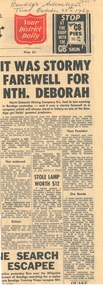
Newspaper - THE NORTH DEBORAH GOLD MINE CO - NEWSPAPER ARTICLE ON THE NORTH DEBORAH GOLD MINE CO
Newspaper article referring to The North Deborah Gold Mine Co's last meeting in Bendigo. It was a stormy farewell as a few shareholders continually hackled the chairman of the meeting, Mr. C. C. Maskiell, and generally endeavored to disrupt the meeting. Article from the Bendigo Advertiser, Tues, October 28th, 1969.newspaper, bendigo advertiser, the north deborah gold mine co, mr c c maskiell, mr l rubinstein, mr m o'hair, mr g a pell, mr john stanistreet, cornelius and co, d a o clinton, r burdett, i p cornelius, k fraenkel, poseidon n l, ralph w king & yulli, sydney stock exchange ltd -
 Bendigo Historical Society Inc.
Document - NEW MOON MINE - NOTES ON THE NEW MOON MINE
... DOCUMENT Gold New Moon Mine Notes on the New Moon Mine ...Handwritten notes on the New Moon Mine on the Garden Gully Line of Reef. Notes include depth of Shaft, locality, Formation & Registration, Last year of production 1931, Size of lease, Early History, Plant, Poppet Legs, Telephone & Electric Signalling, Gold Obtained, Prominence, Total Gold Production and Dividends. ( duplicate of record 3559.1)document, gold, new moon mine, notes on the new moon mine, garden gully line of reef, prospector's vote, h harkness & coy, thompson & co of castlemaine, bendigo amalgamated goldfields coy, mines dept special edition australian mining standard 1/6/1899, mines dept annual and quarterly reports, a richardson -
 Bendigo Historical Society Inc.
Photograph - Victoria Hill, Bendigo, 1973
Gold was discovered on Victoria Hill in 1854 and by 1861, 1,200,000 ounces of gold had been extracted from the site. The first claim was bought for 80 pounds by Prussian immigrant Christopher Ballerstedt and his son Theodore. Christopher Ballerstedt was nicknamed the "Father of the Hill" and was the first to prove that gold reefs extended below the surface. His 200-foot plus mine shafts yielded quartz rich with gold, inspired other miners, and were instrumental in Bendigo becoming the world's deepest and richest goldfield. The site still features relics of nineteenth century mining including quartz crushing machinery and the foundations of George Lansell’s 180 mine. These features are characteristic of Bendigo’s mining history and represent two prominent nineteenth century miners, Christopher Ballerstedt and George Lansell, who held important roles in the development of Bendigo. Victoria Hill Quartz Gold Mines are registered as a site of significance. The site is of historical, archaeological and scientific importance to Victoria. The mines represent the symbolic heart of Bendigo’s gold mining history and the importance that mining played in wealth creation and the development of Victoria. The diggings reserve is accessed from the rear of Albert Richardson Reserve located at 40-56 Marong Road, Ironbark. The site has steep and unformed paths and is closed to the public at dusk. It is important to stay to the paths to avoid the diggings. Interpretive signs help visitors to appreciate the importance of the site and the remaining relics of Bendigo’s mining history.Victoria Hill Ironbark, Bendigo. Photos of the poppet head, sand heap, tailings, shafts and tunnels. Before development into a tourist attraction.history, bendigo, victoria hill, ironbark, diggings -
 Bendigo Historical Society Inc.
Document - VICTORIA HILL - MISCELLANEOUS NOTES ON VICTORIA HILL
Handwritten notes mentioning sign posts at Victoria Hill, Mine Workers' Wages, a note asking Father Stockdale if it would be possible to type a copy of the 'History of the Victoria Hill' for Rotary Club of Bendigo South', Notes on the Sacred Heart Cathedral and mentions The Wesley Methodist and St Johns Presbyterian Churches and All Saints Pro Cathedral, Bradmill, Bendigo Creek, Shamrock Shaft, Central Deborah Gold Mine, Girton College, Horwood's Foundry and the History We Have.document, gold, victoria hill, victoria hill, miscellaneous notes on victoria hill, old chum shaft, ballerstedts first open cut, mine workers' wages, father stockdale, rotary club of bendigo south, bradmill, bendigo creek, shamrock shaft, central deborah, gold mine, girton college, horwood's foundry, sacred heart cathedral, lansell's big 180, flying fox at cent blue, len bennet, wesley methodist church, st johns presbyterian church, all saints pro cathedral, mr derham, national trust day, bendigo potery, h biggs, clark jeffrey, city council b & d t a -
 Bendigo Historical Society Inc.
Document - VICTORIA HILL - THE RICH VICTORIA HILL AND IT'S HISTORICAL ASSOCIATIONS
Multiple handwritten and carbon copies referring to Victoria Hill. Mentioned in the notes are places of interest between Ironbark and Victoria Hill areas, history of the area and signposts for the Victoria Hill area.document, gold, victoria hill, victoria hill, the rich victoria hill and it's historical associations, j n macartney, quartz miners' arms hotel, ironbark methodist church, greek orthodox church, conrad heinz, john brown industries knitwear factory, little 180 mine, george lansell, british & american hotel, victoria reef gold mining coy, manchester arms hotel, housing commission homes, the ironbark (victoria reef gold), hercules & energetic, midway, wittscheibe, gt central victoria, wm rae, mr and mrs conroy, mrs lavery, central nell gwynne, moorhead's shop, gill family, gold mines hotel, david chaplin sterry, new chum and victoria mine, p m g repeater station, old chum mine, pioneer, rotary club of bendigo south, north old chum mine, ballerstedt's first open cut, lansell's big 180 mine -
 Bendigo Historical Society Inc.
Document - VICTORIA HILL - QUESTION 5 ON VICTORIA HILL
Handwritten notes and carbon copy titled Question 5. Notes refer to Victoria Hill being opened up by Theodore Ballerstedt and his son early in 1854. Theodore Ballerstedt left for Germany having sold his home, crushing battery and mine to Mr. Geo Lansell. He called the mine the '180'. Next mine north to the '180' was the Victoria Quartz. Also contains notes on machinery, geological formations and earning from the mines.document, gold, victoria hill, victoria hill, question 5 on victoria hill, theodore ballerstedt, mr geo lansell, fortuna villa, commonwealth survey regiment, the 180, ballerstedt's original open cut, bendigo south rotary club, john wybrandt, north old chum coy, victoria quartz, victoria reef quartz company, mr william rae, a roberts & sons united ironworks, australian mining standard special edition 1899, bendigo advertiser 10/2/1897, a harkness & coy, bendigo advertiser 30/6/1910 page 5, rae's open cut, e j dunn, bendigo saddle reefs, wittscheibe's 'jeweller's shop', roberts & frost, ashley noy & coy, grant & co, woodward & son, couth allen and co, taylor gould and co, crawshaw & co, roberts & co -
 Bendigo Historical Society Inc.
Document - MINING REPORTS - DIAMOND HILL - NELL GWYNNE LINE
... beside them. Mines mentioned are:- North Bendigo, Nell Gwynne... North Bendigo Nell Gwynne Goldfields North Goldfields Ext'd ...Handwritten notes with name of mine, height of sill and depth of bottom level. Four mines have the name of a gully beside them. Mines mentioned are:- North Bendigo, Nell Gwynne, Goldfields North, Goldfields Ext'd, South Concord and the Concord.document, gold, mining reports, diamond hill nell gwynne line, north bendigo, nell gwynne, goldfields north, goldfields ext'd, south concord, concord -
 Bendigo Historical Society Inc.
Document - Jonathan Harris / Axedale
Jonathan Harris was born in Sussex England in 1822. His father Jonathan Snr was transported to Australia and his wife obtained permission to follow him as a free settler when Jonathan jnr was about 7 yrs.In 1842, Jonathan snr (who held a ticket of leave) and his son Jonathan Jnr were found guilty of theft and transported to Tasmania. Family history suggests that following his term, Jonathan jnr became a police detective before returning to Victoria. He and his wife had a store at Third White Hill in Bendigo and one day while walking to Eaglehawk, Jonathan found a rich vein of gold in what was to become the Hustlers Mine. He took large samples to England for crushing and subsequently sold his claim. Upon returning to Melbourne he conducted a business before taking up land at Axedale. He farmed here, including the growing of apples up until his death 20/7/1881. His efforts must have been successful as following his death the sale of property at Axedale included two pieces of land that each had two cottages that had been rented out. Jonathan was also on the board of the Axedale School.An eight page document with newspaper articles and information about the life of Axedale man Jonathan Harris.jonathon harris, axedale, mining. -
 Bendigo Historical Society Inc.
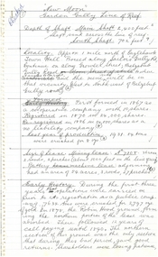
Document - VICTORIA HILL - THE VICTORIA HILL PROJECT FIRST STAGE 1971 - 1972
Handwritten (a) and carbon copy (b) of notes on work to be done on the first stage of the Victoria Hill Project. Also mentioned is the restoration of the Central Nell Gwynne Poppet Legs for use as a lookout to view Bendigo and Eaglehawk. Signed by A. Richardson.document, victoria hill, the victoria hill project first stage 1971 - 1972, ballerstedt's open cut, crushing battery, wittscheibe's jeweller's shop, luffsman & sterry claim, david sterry, gold mines hotel, whip windless and whims, the bendigo and district tourist association, the central nell gwynne poppet legs, a richardson -
 Bendigo Historical Society Inc.
Document - VICTORIA QUARTZ - VICTORIA QUARTZ MINE MISHAP
... DOCUMENT Gold Victoria Quartz Victoria Quartz Mine Mishap ...One handwritten and one typed copy of an article in the Bendigo Advertiser dated Wednesday February 3, 1897. The article referred to an overwinding incident at the Victoria Quartz Mine. It was a new winding plant. A lever would not move and with the motion of the engine, which he could not check, the cage was rapidly taken to the popper heads. It was held there by the safety catches and the cable detached. And damaged portion of the rails at the top of the legs and some iron and timber on both the old and new engine houses. It appeared the valve refused to work because the lubrication was found to be empty.document, gold, victoria quartz, victoria quartz mine mishap, bendigo advertiser 3/2/1897, big 180, little 180, roberts & son, mr john ennor, mr masters, mr albert richardson -
 Bendigo Historical Society Inc.
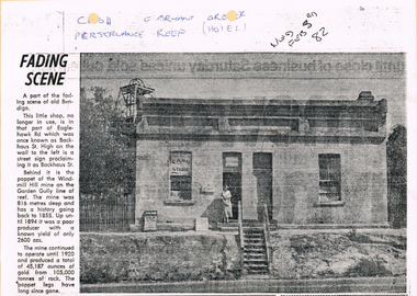
Newspaper - LONG GULLY HISTORY GROUP COLLECTION: E BRYANT - GROCER
BHS CollectionCopy of a newspaper article titled Fading Scene. Photo shows a building with a stairway leading down to the road in front of it and a lady standing in the doorway. One window has Cash Store printed on it and there are two placards leaning on the building to the left of the lady. Each side of the building are shrubs and picket fence. In the background to the left is the poppet of the Windmill Hill Mine on the Garden Gully line of reef. It is in that part of Eaglehawk Rd which was once known as Backhaus St. High on the wall to the left is a street sign proclaiming it as Backhaus St. Written above the photo is C-sh, E Bryant, Gro-er (there are holes through the words), Perseverance Reef (Hotel). Wed Feb 3rd 82. Article is mounted on yellow card which is mounted on purple card and laminated.bendigo, history, long gully history group, the long gully history group - e bryant - grocer, windmill hill mine, garden gully line of reef, e bryant, perservance reef (hotel) -
 Bendigo Historical Society Inc.
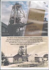
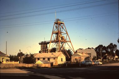
Photograph - CENTRAL DEBORAH GOLD MINE
DVD Mine of the Deborah anticline. DVD commemorates the 60th anniversary of the closure of the Central Deborah, which was one of the last mines to close on the Bendigo field. -
 Bendigo Historical Society Inc.
Plan - Great Extended Hustlers, April, 2014
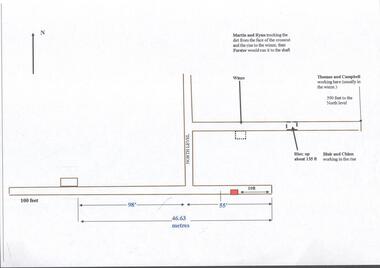
Seven men were killed at the Great Extended Hustler's mine disaster on 2nd May 1914 by an explosion of dynamite occurring as the men were waiting at the plat to ascend the mine at the end of their shift. No blame was attached to anyone in the findings of the inquisition. It was unknown what caused the dynamite to explode. This document formed part of the research done at the time by Bendigo Historical Society, of the 100 years commemoration of the mine disaster, held at Hustler's Hill in 2014. One page plan, computer generated, annotated to show the worksite of the miners prior to when the explosion occurred at the Great Extended Hustlers mine in May 1914. The location of Martin, Ryan, Thomas, Campbell, Blair and Chinn are described. great extended hustlers, goldmining, accident, 1914 -
 Bendigo Historical Society Inc.
Document - Great Extended Hustlers Gold Mine, Albert Richardson
Seven men were killed at the Great Extended Hustler's mine disaster on 2nd May 1914 by an explosion of dynamite occurring as the men were waiting at the plat to ascend the mine at the end of their shift. No blame was attached to anyone in the findings of the inquisition. It was unknown what caused the dynamite to explode. This document formed part of the research done at the time by Bendigo Historical Society, of the 100 years commemoration of the mine disaster, held at Hustlers Hill in 2014. Six page copy of research document, describing the history and geology of the Great Extended Hustlers Mine and the Great Extended Hustlers Reef Q.M. Co.. Topics include: general overview of history, mines along the Hustlers line, characters of the saddle reefs, gold occurrences, effect of pitch, influence of faulting, payable reefs and saddle reefs and spurs. Mine overview researched by Mr. Albert Richardson. great extended hustlers, goldmining, hustlers consols, united hustlers and redan, k.k. mine, comet, hustlers reef no. 1, hustlers reef, hustlers royal reserve co., park shaft, hustlers royal reserve no. 2, city shaft, fortuna hustlers -
 Bendigo Historical Society Inc.
Slide - HORWOOD COLLECTION: CENTRAL DEBORAH, c1965
... Horwood Collection. Central Deborah Gold Mine Violet Street...Horwood Collection. Central Deborah Gold Mine Violet Street... Collection. Central Deborah Gold Mine Violet Street Bendigo. Poppet ...BHS CollectionHorwood Collection. Central Deborah Gold Mine Violet Street Bendigo. Poppet head has flagpole. Shed for winding machine is off to the right on the creek side, change rooms are along side fence and office is in front of the poppet head. Markings: Central Deborah High Street Bendigo 16 OCT65MKodakmine, gold, central deborah gold mine, horwood collection. central deborah gold mine violet street bendigo. poppet head flagpole. shed for winding machine to right on creek side, change rooms side fence office front poppet head -
 Bendigo Historical Society Inc.
Document - The Flooded Mine, John McCaviston's Escape, April, 2014
Seven men were killed at the Great Extended Hustler's mine disaster on 2nd May 1914 by an explosion of dynamite occurring as the men were waiting at the plat to ascend the mine at the end of their shift. No blame was attached to anyone in the findings of the inquisition. It was unknown what caused the dynamite to explode. Three page typed document by Albert Richardson. Copy of handwritten document. 'The Flooded Mine, John McCaviston's Wonderful Escape' by G. Mackay (History of Bendigo). Article details the events that surrounded the flooding that occurred at the Hustlers Reef Company's mine on 13th December 1873. Water was being drained from the adjoining old workings of Latham and Watson, when the flow increased markedly, causing flooding. John McCaviston was the 'shift boss'., R. Jackson the Manager. McCaviston was saved after spending over 20 hours in a level.3527.2 on bottom of all pages. Duplicate copy. great extended hustlers, goldmining, accident, quartz, mining, flooding of mine, john mccaviston, mine rescue, r. jackson, latham and watson -
 Bendigo Historical Society Inc.
Document - Geological Survey of Victoria, Hustlers Line of Reef, Bendigo, April, 2014
Seven men were killed at the Great Extended Hustler's mine disaster on 2nd May 1914 by an explosion of dynamite occurring as the men were waiting at the plat to ascend the mine at the end of their shift. No blame was attached to anyone in the findings of the inquisition. It was unknown what caused the dynamite to explode. This document formed part of the research done at the time by Bendigo Historical Society, of the 100 years commemoration of the mine disaster, held at Hustler's Hill in 2014. Seven page photocopy of Department of Mines, Bulletin, Geological Survey of Victoria, Hustlers Line of Reef, Bendigo, No. 33 by H.S. Whitelaw. Includes plan of Hustlers Royal Reserve No. 2, (main shaft) showing location on Pall Mall, and location of Post Office and Law Courts; plan of location of Hustlers Royal Reserve No. 2 (Park Shaft) showing Jail (sic), Camp Hill State School, two 'lagoons' in between tennis court, croquet court and bowling green; a plan of the Great Extended Hustler's Shaft and two copied images of Hustler's Hill showing mining buildings, poppet heads and chimneys. Comet, K.K., Hustler's No. 1, Old Comet and United Hustler's and Redan Mines are shown in the images. great extended hustlers, goldmining, accident, quartz, mining, k.k. mine, comet mine, hustler's line of reef, old comet, united hustler's, redan -
Bendigo Historical Society Inc.
Document - Great Extended Hustlers Shaft, Hustlers Reef, Bendigo, April, 2014
Seven men were killed at the Great Extended Hustler's mine disaster on 2nd May 1914 by an explosion of dynamite occurring as the men were waiting at the plat to ascend the mine at the end of their shift. No blame was attached to anyone in the findings of the inquisition. It was unknown what caused the dynamite to explode. This document formed part of the research done at the time by Bendigo Historical Society, of the 100 years commemoration of the mine disaster, held at Hustler's Hill in 2014. Six page photocopy of report on the Great Extended Hustlers Shaft, presented in chronological order. Research undertaken by David Bannear in 1992 as part of a wider study on the Bendigo goldfields.great extended hustlers, goldmining, accident, 1873, david bannear -
Bendigo Historical Society Inc.
Document - Hustlers Line of Reef, Bendigo, South Portion, April, 2014
Seven men were killed at the Great Extended Hustler's mine disaster on 2nd May 1914 by an explosion of dynamite occurring as the men were waiting at the plat to ascend the mine at the end of their shift. No blame was attached to anyone in the findings of the inquisition. It was unknown what caused the dynamite to explode. This document formed part of the research done at the time by Bendigo Historical Society, of the 100 years commemoration of the mine disaster, held at Hustler's Hill in 2014. One page photocopy of plan of mining leases on the south portion of the Hustlers Line of Reef. Written underneath plan 'Wood & McNair, Sharebrokers, Beehive Chambers, Bendigo'. Fortuna Hustlers Co., Hustlers Royal Reserve No 2; Great Extended Hustlers Co., Hustlers Reef Co., Hustlers Reef No. 1 and United Hustlers & Redan Co. showing shares held and length of lease are listed on page. great extended hustlers, goldmining, accident, 1873 -
Bendigo Historical Society Inc.
Photograph - Great Extended Hustlers Gold Mine Sandhurst, April, 2014
Seven men were killed at the Great Extended Hustler's mine disaster on 2nd May 1914 by an explosion of dynamite occurring as the men were waiting at the plat to ascend the mine at the end of their shift. No blame was attached to anyone in the findings of the inquisition. It was unknown what caused the dynamite to explode. This document formed part of the research done at the time by Bendigo Historical Society, of the 100 years commemoration of the mine disaster, held at Hustler's Hill in 2014. Two pages of photocopies of images from the 'Australasian Sketcher' May 17th. 1873, of the Great Extended Hustlers Gold Mine Sandhurst. First page: across top of image 'Quartz Mining - The Great Extended Hustlers Mine, Sandhurst'. Across bottom of image ' General View of the Principal Shafts'. Image shows mine buildings, trestle way, mine dam in foreground, poppet head in background. Mining chimneys in background. Second page: same view as above with five small images of mine operations below; men underground, men in mine cate, man pushing ore truck. great extended hustlers, goldmining, accident, 1873 -
 Bendigo Historical Society Inc.
Document - Hustlers Line of Reef, Bendigo, South Portion, April, 2014
Seven men were killed at the Great Extended Hustler's mine disaster on 2nd May 1914 by an explosion of dynamite occurring as the men were waiting at the plat to ascend the mine at the end of their shift. No blame was attached to anyone in the findings of the inquisition. It was unknown what caused the dynamite to explode. This document formed part of the research done at the time by Bendigo Historical Society, of the 100 years commemoration of the mine disaster, held at Hustler's Hill in 2014. One page photocopy of plan of mining leases on the south portion of the Hustlers Line of Reef. Written underneath plan 'Wood & McNair, Sharebrokers, Beehive Chambers, Bendigo'. Fortuna Hustlers Co., Hustlers Royal Reserve No 2; Great Extended Hustlers Co., Hustlers Reef Co., Hustlers Reef No. 1 and United Hustlers & Redan Co. showing shares held and length of lease are listed on page. great extended hustlers, goldmining, accident, 1873 -
 Bendigo Historical Society Inc.
Document - Great Extended Hustlers ,Hustlers Reef, Bendigo, April, 2014
Seven men were killed at the Great Extended Hustler's mine disaster on 2nd May 1914 by an explosion of dynamite occurring as the men were waiting at the plat to ascend the mine at the end of their shift. No blame was attached to anyone in the findings of the inquisition. It was unknown what caused the dynamite to explode. This document formed part of the research done at the time by Bendigo Historical Society, of the 100 years commemoration of the mine disaster, held at Hustler's Hill in 2014. Two page photocopy of article on the Great Extended Hustler's Reef Q.M. Co. Company formed in 1865 and area known as 'the first spot in Bendigo at which quartz had been systemically mined for gold'.great extended hustlers, goldmining, accident, 1873, david bannear, quartz, mining -
 Bendigo Historical Society Inc.
Document - VICTORIA HILL - THE RICH VICTORIA HILL 150,000 OZ OF GOLD IN SIX YEARS
Typed notes titled The Rich Victoria Hill - 150,000 oz of Gold in Six Years. Some handwritten notes have been added. Notes give a brief outline of the Victoria Hill. It also mentions the signposts at Victoria Hill.document, gold, victoria hill, victoria hill, the rich victoria hill 150, 000 oz of gold in six years, gold mines hotel, rotary club of bendigo south, city council, bendigo and district tourist association, lansell's 180, victoria quartz, central deborah mine, ballerstedt's first open cut, theodore ballerstedt, ballerstedt's 2nd open cut, 20 head crushing battery stampers, concrete dam, victoria quartz mine, rae's open cut, quartz roasting, great central victoria (midway), a richardson -
 Bendigo Historical Society Inc.
Document - VICTORIA HILL - BENDIGO BRANCH HISTORICAL SOCIETY - MINE TOUR
... VICTORIA HILL - BENDIGO BRANCH HISTORICAL SOCIETY - MINE... Bendigo Branch Historical Society Mine Tour... Society Mine Tour All Saints Church Joseph La Trobe Bendigo's ...Typed notes for a tour of the area. Areas mentioned are: Hospital Hill, The Central Deborah Mine, New Chum Railway Mine, The Rocks, New Chum Hill, Victoria Hill, Central Nell Gwynne, Rae's Open Cut, Housing Commission Homes and Latham and Watson's. Description of machinery at the Central Deborah Mine, yields, dividends, depth of shafts and directions to get ot the various places is included.document, gold, victoria hill, bendigo branch historical society mine tour, all saints church, joseph la trobe, bendigo's first hospital, sacred heart cathedral, the central deborah mine, city council, londonderry west shaft, new red, white and blue consolidated (big blue), a roberts & sons, big deborah, the new golden fleece, new chum goldfields, central wattle gully mine chewton, virginia consols, black's quarries coldstream, thompson's engineering and pipe co ltd castlemaine, new chum railway mine, golden square methodist church, the rocks, e j dunn, gold monument, shamrock mine, mt alvernia hospital, j b lazarus, john brown knitwear factory, gold fmines hotel, david sterry, new chum hill, fortuna villa, geo lansell, theodore ballerstedt, a h q survey regiment headquarters, old chum mine, central nell gwynne, rae's open cut, theodore ballerstedt, new chum syncline, little 180 mine, victoria quartz, wittcheibe's 'jeweller's shop', adventure, advance, cinderella, j n macartney, bendigo goldfields registry 1870, wm rae, johnson's devonshire mine, snobs hill mine, ellenborough mullock heap, belmont mullock heap, sadowa, st mungo, united devonshire, mechanic's institute, log lock-up, court house, j b watson, housing commission homes, hustlers hill, latham and watsons', the great extended hustlers, a richardson -
 Bendigo Historical Society Inc.
Document - VICTORIA HILL - NOTES ON MINES
Printed notes on some mines. Mines mentioned are: Little '180', South Ironbark, Ironbark, Hercules, Central Nell Gwynne and the New Chum Syncline. Notes include depth of shafts, machinery, poppet legs, gold yields and Dividends. Written in ink at the bottom: Albert - a sample of your work - H Biggs.document, gold, victoria hill, notes on mines, little '180', john brown knitwear factory, roberts & sons, south ironbark, victoria consols east shaft, rae's hill, ironbark, manchester arms, unity mine, wattle gully mine chewton, hercules, hercules and energetic, bendigo amalgamated goldfields coy, long gully post office, wheal-owl, central nell gwynne, bendigo city council, goldmines hotel, mr jack barker, bendigo and district tourist association, the new chum syncline, h biggs -
 Bendigo Historical Society Inc.
Document - VICTORIA HILL - VICTORIA HILL AND NEW CHUM HILL
Typed notes on Victoria Hill and New Chum Hill. Notes give location, value of gold and plans for a mining museum.document, gold, victoria hill, victoria hill and new chum hill, john neil macartney, the age, the australasian, bendigo goldfields registry 1871, victoria reef quartz mine, north old chum, victoria consols, new chum and victoria, pioneer, lansell 222 mine, lazarus, barnet lazarus, mt. alvernia hospital, fortuna villa, george lansell, a. h. q. survey regiment, central red white and blue, hudsons, burrowes & sterry, b c v channel 8, bendigo and district tourist association, section 14 of the lands act 1958, mr a r richardson, cr t r flood, tourist association