Showing 9778 items
matching east street
-
 Bendigo Historical Society Inc.
Map - CROSBIE : COUNTY OF BENDIGO, 28-9-76
Map. Crosbie, County of Bendigo, County of Rodney, Mt. Pleasant Creek, Weston, Toolleen, Redcastle, Dargile, Knowsley East. W.E. Porter, draughtsman, August 1878. Photo-Lithographed at the Department of Lands and Survey, Melbourne, J. Noune,28-9-76. (number 113 in map cupboard 1)W.E. Porter, Draughtsmanmap, bendigo, crosbie -
Bendigo Historical Society Inc.
Map - WESTON : COUNTY OF BENDIGO : COUNTY OF RODNEY, 4-5-21
Map. Weston, County of Bendigo, County of Rodney, Muskerry, Crosbie, Knowsley East, Knowsley, Axedale. Back Creek. By authority A.J. Mullett, Government Printer, Melbourne. Photo-Lithographed at the Department of Lands and Survey, Melbourne by W.J. Butson 4-5-21. Price 1/-. (number 108 in map cupboard 1)A.J. Mullett, Government Printer, Melbourne.map, bendigo, weston -
Bendigo Historical Society Inc.
Map - KNOWSLEY EAST : COUNTY OF BENDIGO, 18-112-77
Map. Knowsley East, County of Bendigo, County of Rodney, Weston, Knowsley, Crosbie, Dargile, Heathcote, Forest Creek, Shingle Hut Creek, Mt. Camel Estate, Sheep Station Creek, Mount Ida Creek. Photo-graphed at the Department of Lands and Survey, Melbourne by J. Noune 18-12-77, (number 104 in map cupboard 1)J. Nounemap, bendigo, knowsley east -
Bendigo Historical Society Inc.
Map - KNOWSLEY : COUNTY OF BENDIGO, 7-11-1941
Map. Knowsley, County of Bendigo, County of Rodney, Weston, Axedale, Eppalock, Knowsley East, Langwornor, Heathcote, Campaspe River, Mt. Ida Creek or Wild Duck Creek, Sandhurst and Heathcote Railway, Kilmore-Heathcote-Bendigo Road. Knowsley Station Ground. Shingle Hut Creek, Forest Creek. By authority H.E. Daw, Government Printer, Melbourne. Drawn and reproduced at the Department of Lands and Survey, Melbourne. 7-11-1941. Price 2/-. (number 103 in map cupboard 1)H.E. Daw, Government Printer, Melbourne.map, bendigo, knowsley -
Bendigo Historical Society Inc.
Map - KNOWSLEY : COUNTY OF BENDIGO, 21-1-19
Map. Knowsley, County of Bendigo, County of Rodney, Weston, Crosbie, Knowsley, Dargile, Heathcote, Shingle Hut Creek, Sheep Station Creek, Forest Creek, Bendigo and Wallan Railway, Mt. Ida Creek. By authority A.J. Mullett, Government Printer, Melbourne. Photo-Lithographed at the Department of Lands and Survey, Melbourne by W.J. Butson 21-1-19, Price 1/-. (number 102 in map cupboard 1)A.J. Mullett, Government Printer, Melbourne.map, bendigo, knowsley east -
Bendigo Historical Society Inc.
Map - HEATHCOTE : COUNTY OF BENDIGO
Map. Heathcote, County of Bendigo, County of Dalhousie, Knowsley, Knowsley East, Dargile, Costerfield, Warrowitue, Tooborac, Langwornor, Argyle Station Ground, Bendigo to Heathcote to Kilmore Railway Line, Township of Heathcote, C.R.B. Main Road. Mount Ida Creek, Wild Duck Creek, Meadow Valley Creek. By Authority H.J. Green, Govt. Printer, Photo-Lithographed at the Department of Lands and Survey, Melbourne by W.J. Butson, Price 1/-. (number 91 in map cupboard 1)H.J. Green Govt. Printer.map, bendigo, heathcote -
 Bendigo Historical Society Inc.
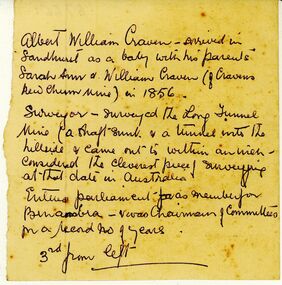
Document - ALBERT WILLIAM CRAVEN INFORMATION
Unknown author, handwritten notes pertaing to life of Albert William Craven. Craven of Cravens New Chum Mine in 1856. Surveyed the 'Long Tunnel Mine' [North/East Vic?] Entered parliament as member for Benambra. Notes pertained to lost photograph.gold mining, miners' safety cage, albert william craven. -
Bendigo Historical Society Inc.
Map - YARRAYNE : COUNTY OF BENDIGO, 6-1-32
Map. Yarrayne, County of Bendigo, Janiember East; Pompapiel, Salisbury, Bridgewater, Salisbury West, Powlett. Photo-Lithographed at the Department of Lands and Survey, Melbourne. Price 2/-. 6-1-32. (number 12 in map cupboard 1)H.J. Green, Government Printermap, bendigo, yarrayne -
Bendigo Historical Society Inc.
Map - WANURP : COUNTY OF BENDIGO, 1-12-33
Map. Wanurp, County of Bendigo, Terrick Terrick East, Mitiamo, Milloo, Pannoobamawm. By authority H.J. Green, Government Printer.Photo-Lithographed at the Department of Lands and Survey, Melbourne. Price 2/-. 1-12-33. (number 9 in map cupboard 1)H.J. Green, Government Printermap, bendigo, wanurp -
Bendigo Historical Society Inc.
Map - POMPAPIEL : COUNTY OF BENDIGO, 1-10-27
Map. Pompapiel, County of Bendigo, Calivil, Janiember East, Yarrayne, Salisbury, Yallook, Talambe, Judyong Creek, Bullock Creek, Pompapiel Creek, Edeyrn Estate. Photo-Lithographed at the Department of Lands and Survey, Melbourne by W.J. Butson, 1-10-27, Price 1/-. (number 4 in map cupboard 1)W.J. Butson, Government Printermap, bendigo, pompapiel -
Bendigo Historical Society Inc.
Map - PANNOOBAMAWM : COUNTY OF BENDIGO, 1957
Map. Pannoobamawm, County of Bendigo. By Appointment W.M. Houston, Government Printer, Melbourne. Drawn and reproduced at the Department of Lands and Survey, Melbourne. Price 2/-.1957. Turrumberry, Terrick Terrick East, Wanurp,Pannoomilloo, Bamawm, Pannoobamawm. (number 2 in map cupboard 1)W.M. Houston, Government Printermap, bendigo, pannoobamawm -
 Port Melbourne Historical & Preservation Society
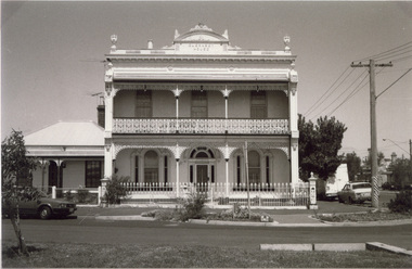
Photograph - Guernsey House, Esplanade East, Port Melbourne, Arthur Rowan, 1986
As a member of the Port Melbourne Historical and Preservation Society, donor Arthur ROWAN photographed a series of significant buildings in the Port and South Melbourne area over several years. A selection of nineteen of these was presented to the Port Melbourne Society in 1993. Guernsey House, 232 Esplanade East. Private home established in 1883 [Eastern shore of Lagoon] First owner: Peter GRUT and his wife Mary, parents of Henry Brouard GRUT, Peter Gallienne GRUT and John Bichard GRUT. Peter G and John B both became architects.Small print mounted on white card, with mounted, typed caption: Guernsey House, 232 Esplanade Eastbuilt environment - domestic, sandridge lagoon, arthur rowan, peter grut, guernsey house, mary grut, peter gallienne grut, henry brouard grut, john bichard grut -
Port Melbourne Historical & Preservation Society
Plan - Inner East, Ferry Terminal, Station Pier, Port Melbourne, Engineering Division, Port of Melbourne Authority, 1983
Plan - General arrangement - Station Pier - Inner East - ferry terminalmelbourne harbor trust - port of melbourne authority -
Port Melbourne Historical & Preservation Society
Plan - New gantry, Inner East, Ferry Terminal, Station Pier, Port Melbourne, Engineering Division, Port of Melbourne Authority, 23 Apr 1985
Plan - General arrangement of new gantry at Station Pier Inner East Ferry Terminalmelbourne harbor trust - port of melbourne authority -
Port Melbourne Historical & Preservation Society
Plan - Operation geometry of gantry, Inner East, Ferry Terminal, Station Pier, Port Melbourne, Engineering Division, Port of Melbourne Authority, 27 May 1985
Plan - Operation geometry of gantry at Station Pier Inner East Ferry Terminalmelbourne harbor trust - port of melbourne authority -
Port Melbourne Historical & Preservation Society
Plan - Operation geometry of temporary gantry, Inner East, Ferry Terminal, Station Pier, Port Melbourne, Engineering Division, Port of Melbourne Authority, 20 May 1985
Plan - Operation geometry of temporary gangway at Station Pier Inner East Ferry Terminalmelbourne harbor trust - port of melbourne authority -
Port Melbourne Historical & Preservation Society
Map - MMBW, 1895
MMBW 1895 Plan No's. 344 to 349 Segment: Ingles to Bridge, Nott to Esplanade East (on south) Scale 40ft=1" (large)311/H 22melbourne and metropolitan board of works, port melbourne town hall, built environment, business and traders - hotels -
Port Melbourne Historical & Preservation Society
Postcard - Railway Pier, Port Melbourne, 1914
Collected by Alison Kelly when she was caretaking the Missions to Seamen Building 1987-90.One of six postcards, mostly various angles and times of Railway Pier, Port Melbourne. Hand tinted view of east side of Railway Pier, two steamers, one paddlesteamer and train at right.piers and wharves - railway pier -
Port Melbourne Historical & Preservation Society
Photograph - Gasworks demolition, 1979
Six small photographs of gasworks demolition in about 1979 1. Lagoon, Esplanade East, boundary of Lagoon Reserve 2. Upright crash frame 3. Mangled cranes 4. Graham st 5. Fallen crane 6. Fallen cranebuilt environment - industrial, utilities - gas, gasworks, demolition, sandridge lagoon, lagoon reserve -
Port Melbourne Historical & Preservation Society
Audio - Oral History, Silvia Gleeson, 29 May 1991
Interviewed by Pat Grainger at Sylvia's home at 98 Princes Street. Interview used in contributions to the book "They Can Carry Me Out" .Sylvia Gleeson discussing her life in Port Melbourne, particularly in relation to the operation of the kiosk on the East Wing Pier of Station PierDuration 01:03:07families, domestic life, piers and wharves - station pier, business and traders - kiosk, sylvia gleeson -
Port Melbourne Historical & Preservation Society
Photograph - Resiting eastern kiosk, Station Pier, Port Melbourne, Ron Laing, 1993
The kiosk was turned sideways to make room for the TT Lines truck park. It was later extended to the east to create a 90 seat restaurant, known at the turn of the century as Cafe Limani. Part of Ron Laing's collection of photographs taken around Port Melbourne over a thirteen year period. Donated to the PMH&PS by the photographer.A set of 18 colour photographs showing the re-siting of the eastern kiosk on Station Pier (later Cafe Limani) c 1993piers and wharves - station pier, ron laing -
Port Melbourne Historical & Preservation Society
Photograph - Demolition east wing (finger pier) and construction of truck bay and ramp for Abel Tasman and Spirit of Tasmania, Station Pier, Port Melbourne, Ron Laing, 1986 - 1999
Part of Ron Laing's collection of photographs taken around Port Melbourne over a thirteen year period. Donated to the PMH&PS by the photographer.A set of fifty-three colour photographs c1992 covering the demolition of the east wing or finger pier of Station Pier, and construction of the new truck bay and ramp for the Abel Tasman and Spirit of Tasmania.piers and wharves - station pier, ron laing, tt-line co pty ltd -
Port Melbourne Historical & Preservation Society
Photograph - Various reserves, Port Melbourne, Ron Laing, 1986 - 1999
Part of Ron Laing's collection of photographs recording Port Melbourne over a thirteen year period. Donated to the PMH&PS by the photographer.A set of 42 colour photographs of the various reserves including Garden City Reserve, West Gate Park and ibis, Boulevard and site from Webb Dock, new Evans Street gardens on the old railway sidings, and panorama looking east from Webb Dock. 1990sbuilt environment, natural environment, parks and gardens, ron laing -
Port Melbourne Historical & Preservation Society
Photograph - Princes Pier, Port Melbourne, 1940 - 1941
Small sepia photograph of Princes Pier with gantry to left of gatehouse. Ship at inner East. Crowd on gantry and on wharfPort Melbourne 1940-41 (in ballpoint on reverse)piers and wharves - princes pier -
 Port Melbourne Historical & Preservation Society
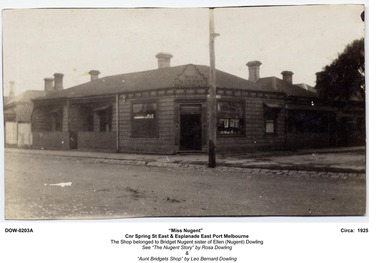
Album - CD-ROM, Miss Nugent's Shop, 2003
Digital album in PDF format of Miss Nugent's shop, Corner Spring St East and Esplanade East Port Melbourne . Plus images of Nugent, Dowling, Maloney and Moloney families.business and traders, domestic life, mary moloney, jim moloney, ellie moloney, ellen dowling nugent, bridget nugent, leo bernard dowling, cath dowling, margaret nugent maloney, tot moloney, ellen hoogen dowling, leo robert dowling, jack moloney, rosa dowling, frank dowling, rob dowling, ellen (nell) dowling, rosa nugent -
 Port Melbourne Historical & Preservation Society
Photograph - Post Office Place, east side, Port Melbourne, Janet and Allen Walsh, 1973
Shot in 1973 with particular interest in architecturePost Office Place, east side. Shows rear of Harpers Oriental Mill on left. 1973 Identified and dated on back in inkbuilt environment - commercial, built environment - domestic, built environment - industrial, post office place, harpers oriental mill -
 Port Melbourne Historical & Preservation Society
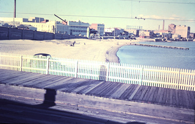
Photograph - Port Melbourne beach front from Station Pier, February, Marie Hillier, Feb 1960
Digital image taken from Station Pier, in February 1960, looking east along beachfront. Image shows part of Centenary Bridge; Swallow and Ariell buildings including chimney (since demolished); London Hotel; Princes St drain pier; Graham St gasometer in background; Sandridge Bay Towers; rotunda. Station pier shows raised pedestrian walkway, vehicle on lower level and rails that extend from station.built environment - commercial, built environment - industrial, natural environment - beaches and foreshore, piers and wharves - station pier, centenary bridge, london family hotel, band rotunda, swallow & ariell ltd, gasometer, sandridge towers, piers and wharves - miscellaneous -
Port Melbourne Historical & Preservation Society
Photograph - Extension of Webb Dock, Port Melbourne, Ron Laing, 1990s
Part of Ron Laing's collection of photographs recording Port Melbourne over a thirteen year period. Donated to the PMH&PS by the photographer.A set of eleven colour photographs of the extensionn of Webb Dock development by reclamation of the bay behind Berths 4 and 5 Eastpiers and wharves - webb dock, ron laing -
Port Melbourne Historical & Preservation Society
Photograph - Sailing Barque, Endeavour (replica), Outer East Station Pier, Port Melbourne, Jan 1995
Group of seven photographs of the Sailing Barque Endeavour (Replica) laying at Outer East Station Pier in January 1995piers and wharves - station pier, transport - shipping, replica endeavour -
Port Melbourne Historical & Preservation Society
Photograph - Morley's Coal Depot, Bay Street, Port Melbourne, Arthur Rowan, 1986
As a member of the Port Melbourne Historical and Preservation Society, donor Arthur ROWAN photographed a series of significant buildings in the Port and South Melbourne area over several years. A selection of nineteen of these was presented to the Port Melbourne Society in 1993.Small print mounted on white card, with mounted, typed caption: Morely's Coal Depot 2 Bay Street, corner Beach Street and Post Office Place. Established 1872. First owner: William T. CLARKE [Photo from north east]built environment - commercial, arthur rowan, william t clarke, morley coal depot, william morley