Showing 4547 items matching "historical map"
-
 Whitehorse Historical Society Inc.
Map, Deep Creek Road, Mitcham, c1975
Enlargement of aerial photograph of area bounded by Dalmar Road, Cray Road, Glenvale Road and Maroondah Highway, MitchamEnlargement of aerial photograph of area bounded by Dalmar Road, Cray Road, Glenvale Road and Maroondah Highway, MitchamEnlargement of aerial photograph of area bounded by Dalmar Road, Cray Road, Glenvale Road and Maroondah Highway, Mitchamcray road, donvale, glenvale road, donvale, maroondah highway, mitcham, dalmor road, mitcham, deep creek road, mitcham, aerial photographs -
Whitehorse Historical Society Inc.
Map, Whitehorse Road, Mitcham, 1972
Enlarged aerial photograph of area around intersection of Whitehorse Road and Heatherdale Roads, Mitcham.Enlarged aerial photograph of area around intersection of Whitehorse Road and Heatherdale Roads, Mitcham.Enlarged aerial photograph of area around intersection of Whitehorse Road and Heatherdale Roads, Mitcham.whitehorse road, mitcham, heatherdale road, mitcham, ringwood, maroondah highway, aerial photographs -
Whitehorse Historical Society Inc.
Map, Whitehorse Road, Blackburn, 1970
Enlarged aerial photograph of area around intersection of Whitehorse and Middleborough Roads, BlackburnEnlarged aerial photograph of area around intersection of Whitehorse and Middleborough Roads, BlackburnEnlarged aerial photograph of area around intersection of Whitehorse and Middleborough Roads, Blackburnwhitehorse road, blackburn, middleborough road, blackburn, maroondah highway, box hill, aerial photographs -
Whitehorse Historical Society Inc.
Map, Walker Park, Nunawading, c1970?
Enlarged aerial photograph of area of Walker Park, Nunawading, 1970 runEnlarged aerial photograph of area of Walker Park, Nunawading, 1970 run.Enlarged aerial photograph of area of Walker Park, Nunawading, 1970 runwalker park, whitehorse road, nunawading, maroondah highway, dunlavin road, nunawading, mitcham technical school, aerial photographs -
Whitehorse Historical Society Inc.
Map, Canterbury Road, Blackburn, 1972
Enlarged aerial photograph of area around the intersection of Canterbury and Middleborough Roads, Blackburn.Enlarged aerial photograph of area around the intersection of Canterbury and Middleborough Roads, Blackburn.Enlarged aerial photograph of area around the intersection of Canterbury and Middleborough Roads, Blackburn.canterbury road, blackburn, middleborough road, blackburn, box hill, craig street, blackburn, hirst street, blackburn, aerial photographs -
Whitehorse Historical Society Inc.
Map, Blackburn Road, Blackburn, 1970
Enlarged aerial photograph of area around the intersection of Blackburn and Canterbury Roads, Blackburn.Enlarged aerial photograph of area around the intersection of Blackburn and Canterbury Roads, Blackburn.Enlarged aerial photograph of area around the intersection of Blackburn and Canterbury Roads, Blackburn.canterbury road, blackburn, blackburn road, blackburn, rosslyn street, blackburn south, masons road, blackburn, lavelle street, blackburn, vernon street, blackburn, wirreanda court, blackburn, aerial photographs -
Whitehorse Historical Society Inc.
Map, Campbell's Croft, c1970
Enlarged aerial photograph of the area around Campbell's Croft Reserve. State aerial Survey, Melbourne, 1970 project. Run 37Enlarged aerial photograph of the area around Campbell's Croft Reserve. State aerial Survey, Melbourne, 1970 project. Run 37Enlarged aerial photograph of the area around Campbell's Croft Reserve. State aerial Survey, Melbourne, 1970 project. Run 37campbells croft, boronia road, vermont, madonna court, vermont, aerial photographs -
Whitehorse Historical Society Inc.
Map, Boronia Road, Canterbury Road intersection, c1970
Enlarged aerial photograph of the intersection of Canterbury and Boronia Roads. State Aerial Survey, Melbourne 1970 project.Enlarged aerial photograph of the intersection of Canterbury and Boronia Roads. State Aerial Survey, Melbourne 1970 project.Enlarged aerial photograph of the intersection of Canterbury and Boronia Roads. State Aerial Survey, Melbourne 1970 project.boronia road, vermont, canterbury road, vermont, mitcham road, vermont, frances avenue, vermont, nurlendi road, vermont, beaumont street, vermont, kingsclere street, vermont, webb court, vermont, aerial photographs -
Whitehorse Historical Society Inc.
Map, Canterbury Road, Vermont, c1970
Enlarged aerial photo of intersection of Canterbury and Boronia Roads. State Aerial Survey, Melbourne 1970 project.Enlarged aerial photo of intersection of Canterbury and Boronia Roads. State Aerial Survey, Melbourne 1970 project.Enlarged aerial photo of intersection of Canterbury and Boronia Roads. State Aerial Survey, Melbourne 1970 project.canterbury road, vermont, boronia road, vermont, mitcham road, vermont, frances avenue, vermont, nurlendi road, vermont, webb court, vermont, vermont primary school, no. 1022, aerial photographs -
Whitehorse Historical Society Inc.
Map, Blackburn Lake, c1968
Enlarged aerial photograph of Blackburn Lake area.Enlarged aerial photograph of Blackburn Lake area.Enlarged aerial photograph of Blackburn Lake area.blackburn lake sanctuary, adult deaf & dumb home, lake road, blackburn, central road, blackburn, aerial photographs -
Whitehorse Historical Society Inc.
Map, Highbury Road, c1970
Enlarged aerial photo of Highbury Park area.Enlarged aerial photo of Highbury Park area.Enlarged aerial photo of Highbury Park area.highbury road, burwood east, gareth drive, burwood east, blackburn road, burwood east, bennett avenue, burwood east, rae street, burwood east, joy street, burwood east, folkestone road, burwood east, burwood east primary school no. 454, aerial photographs -
Whitehorse Historical Society Inc.
Map, Mitcham Road, c1970
Enlarged aerial photograph of intersection of Whitehorse and Mitcham Roads, Mitcham. Scale 1 inch : 40 feetEnlarged aerial photograph of intersection of Whitehorse and Mitcham Roads, Mitcham. Scale 1 inch : 40 feetEnlarged aerial photograph of intersection of Whitehorse and Mitcham Roads, Mitcham. Scale 1 inch : 40 feetmitcham road, mitcham, maroondah highway, mitcham, whitehorse road, mitcham, mitcham primary school, no. 2904, mitcham hotel, aerial photographs -
Whitehorse Historical Society Inc.
Map, Blackburn, 13/01/1977 12:00:00 AM
Enlarged aerial photograph of Blackburn Business Centre. Scale 1:150 metric.Enlarged aerial photograph of Blackburn Business Centre. Scale 1:150 metric.Enlarged aerial photograph of Blackburn Business Centre. Scale 1:150 metric.blackburn, blackburn road, blackburn, south parade, blackburn, railway road, blackburn, maroondah highway, blackburn, whitehorse road, blackburn, chapel street, blackburn, albert street, blackburn, queen street, blackburn, station street, blackburn, blackburn railway station, blackburn primary school, no. 2923, aerial photographs -
Whitehorse Historical Society Inc.
Map, Springvale Road, c1970
Enlarged aerial photo of intersection of Springvale and Whitehorse Roads, Nunawading.Enlarged aerial photo of intersection of Springvale and Whitehorse Roads, Nunawading.Enlarged aerial photo of intersection of Springvale and Whitehorse Roads, Nunawading.springvale road, nunawading, whitehorse road, nunawading, maroondah highway, nunawading, aerial photographs -
Whitehorse Historical Society Inc.
Map, Burwood Highway, c1970
Enlarged aerial photo of area South of Burwood Highway to Dandenong Creek, Vermont South.Enlarged aerial photo of area South of Burwood Highway to Dandenong Creek, Vermont South.Enlarged aerial photo of area South of Burwood Highway to Dandenong Creek, Vermont South.dandenong creek, morack road, vermont south, burwood highway, vermont south, aerial photographs -
Whitehorse Historical Society Inc.
Map, Mitcham Road, c1970
Enlarged aerial photo of the intersection of Mitcham and East Doncaster Roads, Mitcham. Scale 1 inch : 40 feet.Enlarged aerial photo, c1970, of the intersection of Mitcham and East Doncaster Roads, Mitcham. Scale 1 inch : 40 feet.Enlarged aerial photo of the intersection of Mitcham and East Doncaster Roads, Mitcham. Scale 1 inch : 40 feet.mitcham road, mitcham, quarry road, mitcham, doncaster east road, mitcham, wooddale grove, mitcham, mitcham primary school, no. 2904, aerial photographs -
Whitehorse Historical Society Inc.
Letter - Correspondence, Valuation of Abattoirs Paddock lots, 1932
Letter from Shire valuer to Cit of Box Hill re valuations of Abattoir Paddock lots, including map of lots.Letter from Shire valuer to Cit of Box Hill re valuations of Abattoir Paddock lots, including map of lots.Letter from Shire valuer to Cit of Box Hill re valuations of Abattoir Paddock lots, including map of lots.shire of blackburn and mitcham, city of box hill, abattoirs paddock, aspinall's estate, woodhouse grove, box hill north -
Whitehorse Historical Society Inc.
Document, Street names, 1989
Artic;le by Gwenda Trethewy, member of Nunawading Historical SocietyArtic;le by Gwenda Trethewy, member of Nunawading Historical Society, on the history of the Mitcham street names, Endeavour, Flinders, Moresby and Beaufort, Oct - Dec 1989 and map of the area and an extract of the article.Artic;le by Gwenda Trethewy, member of Nunawading Historical Societystreet names, trethewey, gwenda, turner, (commander), nunawading historical society, endeavour street, mitcham, flinders street, mitcham, moresby street, mitcham, beaufort street, mitcham -
Whitehorse Historical Society Inc.
Map, Plan, 1939
Plan of subdivision, part of crown portion 83A and 83, Parish of Nunawading, County of BourkePlan of subdivision, part of crown portion 83A and 83, Parish of Nunawading, County of BourkePlan of subdivision, part of crown portion 83A and 83, Parish of Nunawading, County of Bourkestreet names, parish of nunawading, station street, blackburn, railway road, blackburn, vine street, blackburn, south parade, blackburn, laburnum street, blackburn, main street, blackburn, gardenia street, blackburn, the avenue, blackburn, fuschia street, blackburn, linum street, blackburn -
Whitehorse Historical Society Inc.
Map, Parish of Nunawading, 1939
Plan of subdivision part of crown portions 81, 82 and 89,Plan of subdivision part of crown portions 81, 82 and 89, Parish of Nunawading, County of Bourke, Blackburn Wellington Avenue amended from Stanley RoadPlan of subdivision part of crown portions 81, 82 and 89, street names, parish of nunawading, blackburn road, blackburn, wellington avenue, blackburn, wolseley crescent, blackburn, gordon crescent, blackburn, clarke street, blackburn, central road, blackburn -
 Whitehorse Historical Society Inc.
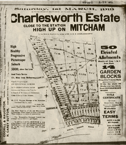
Document, Charlesworth Estate, 1913
Charlesworth Estate, Mitcham. 50 elevated allotments, 1/2 to 1 acre each and 14 garden blocks from 2 to 7 acres each. 1 March 1913.Brochure for auction of Charlesworth Estate, Mitcham. 50 elevated allotments, 1/2 to 1 acre each and 14 garden blocks from 2 to 7 acres each. 1 March 1913. Agents: Coghill & Houghton and H. Carey Sutton.Charlesworth Estate, Mitcham. 50 elevated allotments, 1/2 to 1 acre each and 14 garden blocks from 2 to 7 acres each. 1 March 1913.auctions, charlesworth estate, mitcham, quarry road, doncaster east road, burnett street, harrison street, whitehorse road -
 Whitehorse Historical Society Inc.
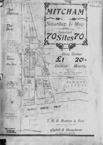
Document, Mitcham, ca 1920
Brochure for auction of 70 sites bounded by Mitcham, Doncaster East and Whitehorse Roads on 1 May ?1920.Brochure for auction of 70 sites bounded by Mitcham, Doncaster East and Whitehorse Roads on 1 May ?1920. Agents: T.R.B. Morton & Sons, Coghill & Haughton.|The home/hospital shown on brochure in Harrison Street near Mitcham Road owned by Dr Drake and later Dr Cochrane was called 'Coombe-Wood'Brochure for auction of 70 sites bounded by Mitcham, Doncaster East and Whitehorse Roads on 1 May ?1920.auctions, doncaster east road, mitcham, whitehorse road, mitcham road, mcdowall street, burnett street, t.r.b. morton & son, coghill & haughton, william street, harrison street, drake, francis, john, dr -
 Whitehorse Historical Society Inc.
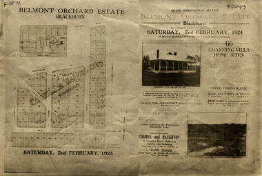
Document, Belmont Orchard Estate, 1924
Brochure for auction of Belmont Orchard Estate, BlackburnBrochure for auction of Belmont Orchard Estate, Blackburn, (now Nunawading) 66 sites, 2 February 1924. Agents: Coghill & Haughton, Frank Fisher.Brochure for auction of Belmont Orchard Estate, Blackburnauctions, belmont orchard estate, patterson street, nunawading, central road, joyce street, lilian street, west avenue -
![Brochure for auction of Eastdawn Estate, Mitcham, 70 lots [20 February 1915]](/media/collectors/56f368632162f118acbff12e/items/60d923316e5f99545134e472/item-media/60d9477c6e5f995451350fb8/item-fit-380x285.jpg) Whitehorse Historical Society Inc.
Whitehorse Historical Society Inc.Document, Eastdawn Estate, 1915
Brochure for auction of Eastdawn Estate, Mitcham, 70 lots [20 February 1915]Brochure for auction of Eastdawn Estate, Mitcham, 70 lots [20 February 1915]. Agents Coghill & Haughton.Brochure for auction of Eastdawn Estate, Mitcham, 70 lots [20 February 1915]auctions, eastdawn estate, mother foster's estate, mitcham road, mitcham, orient avenue, hull parade, vernal avenue -
Whitehorse Historical Society Inc.
Document, Particulars of maintainance works, 1933
Shire of Blackburn and Mitcham - particulars of maintenance works carried out under the maintenance grant for the year ending 30 Jun 1933 and map showing work on the Main Healesville Road and Main Burwood Road.Shire of Blackburn and Mitcham - particulars of maintenance works carried out under the maintenance grant for the year ending 30 Jun 1933 and map showing work on the Main Healesville Road and Main Burwood Road.Shire of Blackburn and Mitcham - particulars of maintenance works carried out under the maintenance grant for the year ending 30 Jun 1933 and map showing work on the Main Healesville Road and Main Burwood Road.local government, shire of blackburn and mitcham, financial documents, maps, burwood road, healesville road, whitehorse road -
Whitehorse Historical Society Inc.
Document, Eastern Freeway Extension, 2000 - 2002
Eastern Freeway ExtensionEastern Freeway Extension- Cost estimates for community consultation option Public consultation process : report on analysis submissions Deep Creek Road - Landscape concept Media Release from Premier of Victoria VicRoads - Works update newsletters Whitehorse City Council minutes VicRoads Correspondence Schwerkolt Cottage Precinct - Concept Plan VicRoads maps.Eastern Freeway Extensioneastern freeway extension, vicroads, victoria. department of infrastructure, city of whitehorse, schwerkolt cottage, landscape planning, maps -
Whitehorse Historical Society Inc.
Map, Map of Mitcham, Tunstall and Blackburn, c1937
Map of Mitcham, Tunststall and Blackburn showing the location of T.M. McDonnell, real estate agent, Whitehorse Road, MitchamMap of Mitcham, Tunststall and Blackburn showing the location of T.M. McDonnell, real estate agent, Whitehorse Road, MitchamMap of Mitcham, Tunststall and Blackburn showing the location of T.M. McDonnell, real estate agent, Whitehorse Road, Mitchammaps, mcdonnell, t.m. -
Whitehorse Historical Society Inc.
Map, Box Hill in 1883, c1933
Map of Box Hill in 1883 showing churches, hotels, etc, linked to ND 4231 '1933 map'Map of Box Hill in 1883 showing churches, hotels, etc, linked to ND4231 '1933 map'Map of Box Hill in 1883 showing churches, hotels, etc, linked to ND 4231 '1933 map'maps, box hill -
Whitehorse Historical Society Inc.
Map, Map of Mont Albert, Box Hill, Surrey Hills and Blackburn, c 1933
Map of Box Hill and Surrounds, showing location of Box Hill Grammar School.Map of Box Hill and Surrounds, showing location of Box Hill Grammar School.Map of Box Hill and Surrounds, showing location of Box Hill Grammar School.maps, box hill grammar school -
Whitehorse Historical Society Inc.
Map, Nunawading, 1966
Nunawading's boundaries, schools, topography and railwaysNunawading's boundaries, schools, topography and railwaysNunawading's boundaries, schools, topography and railwaysmaps, city of nunawading, schools