Showing 11389 items matching "land-clearing"
-
 Port Melbourne Historical & Preservation Society
Book - Technical Appendices, Ewan Ogilvy's Bayside Papers, Box One: Bayside Project EES Statement Vol.2, 1987 - 1998
Ewan Ogilvy, former Melbourne Councillor and also of Community Services Victoria, Inner Urban Ministerial Advisory Committee and Uniting Church's Centre for Urban Research and Action (CURA), was instrumental in social justice approaches to town planning. He and CURA's Social Justice and the City Project funded Port Melbourne community groups protesting against the SCDC development in 1987. His files were presented to the Society in May 2001 on his preparation for leaving Victoria.From Ewan Ogilvy's chronologically organised 'Bayside Papers' relating to the proposed development of Port Melbourne industrial land in the late 1980s: Bayside project Environmental Effects Statement for SCDC proposal Volume 2: Technical Appendices July 1987All items signed 'Ewan Ogilvy'town planning, town planning - proposals shelved - bayside, public action campaigns, environmental issues, ewan ogilvy, centre for urban research and action, sandridge city development co pty ltd, scdc -
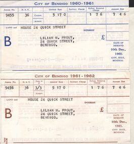 Bendigo Historical Society Inc.
Document - L. PROUT COLLECTION: CITY OF BENDIGO RATE NOTICES
Two city of Bendigo Rate Notices. The first is for 1960-1961 and the second for 1961-1962. Land and house at 24 Quick Street in the name of Lilian M. Prout. The amount due on both is 7 pounds, 4 shillings and 6 pence.organization, government, city of bendigo -
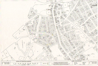 Bendigo Historical Society Inc.
Map - LONG GULLY HISTORY GROUP COLLECTION: LONG GULLY AREA
Copy of a map showing streets and allotments in the Long Gully area, last updated 30/05/97, printed 19/06/97. Made by the Land Titles Office. Some street names, reserves and allotment numbers are printed on the map.bendigo, history, long gully history group, the long gully history group - long gully area, land titles office, office of surveyor general, city of bendigo, shire of marong, state electricity commission -
 Bendigo Historical Society Inc.
Document - MCCOLL, RANKIN AND STANISTREET COLLECTION: GOLD MINING LEASE CROWN LAND, 1937
Document : McColl, Rankin and Stanistreet: gold mining lease crown land 10916 Bendigo. Foolscap size document, includes map County of Bendigo, Parish of Mandurang. Dated 1937 between King George VI and John Jepson Stanistreet.person, mining, john jepson stanistreet, mccoll, rankin and stanistreet: bendigo, mining, goldmining, john stanistreet -
Bay Steamers Maritime Museum
Framed photograph, Lindsay Rex, S. T. Wattle on low loader passing under Bolte bridge, 22/10/2009
Photogtoraph taken during the removal of Wattle from the River Yarra to its temporary storage and restoration site at No 24 South Wharf, Port Melbourne. A very significant moment in the life of the Wattle as this was the first day of the major restoration project that continues from 2009 through 2012 aiming to finish in mid 2013. Prior to this restoration project there was a long lead up to find funding and resources to restore the Wattle and ensure that Wattle was not scrapped. The majority of this preparation and restoration work was and continues to be completed by volunteers.Gilded wooden frame around a colour photograph. Steam Tug Wattle facing aft on a low loader which is passing under the Bolte Bridge. This was towards the end of the tug's land journey from Victoria Harbour to 24 South Wharf.wattle, bolte bridge, river yarra, steam tug, restoration, low loader, port melbourne -
 Whitehorse Historical Society Inc.
Legal record - Document, Forest Hill, 12/08/1913
Photocopy of Certificate of Title. Vol 3715 Fol. 742903 to Julius Draeger, 12 August 1913, for fifteen acres of land being part of Crown Portion 94, including plan of subdivision (P72294) cancelling title. [Contract of Sale ND567]Photocopy of Certificate of Title. Vol 3715 Fol. 742903 to Julius Draeger, 12 August 1913, for fifteen acres of land being part of Crown Portion 94, including plan of subdivision (P72294) cancelling title. [Contract of Sale ND567]Photocopy of Certificate of Title. Vol 3715 Fol. 742903 to Julius Draeger, 12 August 1913, for fifteen acres of land being part of Crown Portion 94, including plan of subdivision (P72294) cancelling title. [Contract of Sale ND567]glebe street, forest hill, land subdivision, draeger, carl julius otto, vicki street, bindy street, lee-ann street -
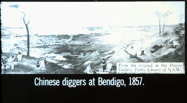 Bendigo Historical Society Inc.
Slide - DIGGERS & MINING. THE CHINESE ON THE GOLD FIELDS, c1857
Diggers & Mining. The Chinese on the Gold Fields. Slide: Chinese diggers at Bendigo, 1857. Slide shows Chinese panning for gold in the almost baron land of Bendigo. Possibly along side the Bendigo Creek. Markings: 28. Used as a teaching aid.hanimounteducation, tertiary, goldfields -
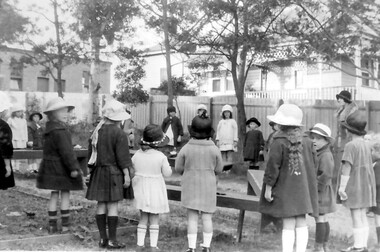 Surrey Hills Historical Society Collection
Photograph, Holy Trinity kindergarten group, 1924, 1924
Norman Carter took many photos of Surrey Hills and Mont Albert from the 1920s; many were associated with events and activities of the Church of England.Black and white photo showing a group of 16 children, mostly girls, and a teacher standing in a circle around a number of benches in the rear of Holy Trinity's land. All are wearing hats. The house behind the church in Montrose Street can be seen.On the back in ink: "Kindergarten outdoors / Leader:- Miss P. Cornell / 18th. May 1924"churches, holy trinity church, anglican church, kindergartens, miss patsy cornell, montrose street, children -
University of Melbourne, Burnley Campus Archives
Newspaper - Newspaper Cutting, The Geelong Advertiser, Horticultural Society of Victoria, 1860
Photocopy of an article in the Geelong Advertiser 15 October, 1860 p3. Description of the first show of the season which included model fruit. Mention of a grant of money to be provided by the Government for the establishment of a Horticultural Garden on a large piece of land provided by the Government.the geelong advertiser, garden show, wax models of fruit, government grant, establishment of burnley gardens -
 Bendigo Historical Society Inc.
Document - RESIDENCE AREAS REGISTER: DOCUMENTS FROM VOLUME 19, 1920-1940
Documents: Collection of drawings, sketches of land allocations (with names) and plans that relate to Residence Areas Register Volume 19.Match page numbers 0f Volume 19 - 11006.1 (Box 56) Covers 1920s to 1930s. Sorted by page number.land sales, residence areas, plans, sandhurst, bendigo -
 Bacchus Marsh & District Historical Society
Map, Maddingley Township, Parish of Parwan, circa 1890s
Maddingley is a locality or township within the broader township area of Bacchus Marsh. This map is not dated. However features in Maddingley which appeared in the 1880s and 1890s are present in the map, These include the Bacchus Marsh Railway Station and the Bacchus Marsh Showgrounds. The main residential and commercial area of Maddingley is shown on this map in an area bounded by Bacchus Street, Barry Street, Griffith Street and Maddingley Road. Other streets visible are Franklin Street, Inglis Street, Labilliere Street, McCrae Street, Moore Street and part of Station Street.A single page paper map showing land allotments, streets, rivers, creeks, park lands, the railway line and Bacchus Marsh railway station in the township of Maddingley. The map is pasted into a bound volume containing 76 maps or plans in total. bacchus marsh victoria maps, maddingley victoria maps, land use, maddingley victoria history -
Port Melbourne Historical & Preservation Society
Audio - PMHPS Meeting, Frank Callaghan, Frank Gordon & Co, Estate agents, Glen Stuart, 25 May 1998
Recording of PMHPS Meeting on 25.05.1998. Recording done by Glen STUART at Port Town Hall. Speaker was Frank CALLAGHAN from Estate Agents Frank Gordon & Co. Discussing land/property sales in Port. Recording duration 49:36.business and traders, frank gordon & co, frank callaghan, built environment - domestic -
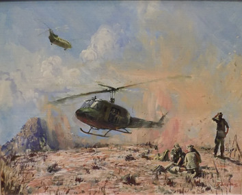 Geoffrey Kaye Museum of Anaesthetic History
Painting, Bruce Fletcher, Dust Off, 1980
The painting was donated to ANZCA in 1995 by Dr Bernard Dunn. Bruce Fletcher, from Melbourne Victoria, studied under William Dargie, who had been an official war artist during the second world war. Fletcher followed the same pathway as his mentor and was the first of two official war artists appointed during the Vietnam War. His artwork are held in the art collection of the Australin War Memorial, Canberra. The title of the painting, 'Dust Off' is a term adopted in Vietnam which refers to the medical evacuation of sick or wounded soldiers, from the field, by a helicopter. It was originally a radio call sign selected from a US Navy Signal Operations book in 1963. [ref. 'Medicine at War. 1950-1972'].In June 2012, a Royal Children's Hospital Anaesthetic Registrar attended a College Tour conducted by Dr Rod Westhorpe when he saw the painting and informed us that the term 'Dust off' emanates from the Korean War and is in fact the acronym for Decisive, Unwavering, Support to our Fighting Forces'. The painting was based on a black and white photograph taken in Vietnam in 1971. An image of the photograph is located in the electronic supplementary file. Oil painting on board of a scene in which a military helicopter is about to land with a group of soldiers in the foreground, one wounded and one soldier standing. A cargo military helicopter is in the distance flying away from the scene. The painting is set in a gold frame.[plaque affixed to centre front of frame] DUST OFF \ BY BRUCE FLETCHER \ DEPICTING THE MEDICAL EVACUATION \ OF WOUNDED SOLDIERS FROM THE FIELD \ IN VIETNAM \ PRESENTED BY \ DR BERNARD L. DUNNpainting, dunn, bernard, fletcher, bruce, vietnam war, dust off -
 Kew Historical Society Inc
Photograph - 8 roomed DF Brick Villa, Kew, J E Barnes, c.1920
Subdivision plans are historically important documents used as evidence of the growth of suburbs in Australia. They frequently provide information about when the land was sold on which a built structure was subsequently constructed as well as evidence relating to surveyors and real estate and financial agents. The numerous subdivision plans in the Kew Historical Society's collection represent working documents, ranging from the initial sketches made in planning a subdivision to printed plans on which auctioneers or agents listed the prices for which individual lots were sold. In a number of cases, the reverse of a subdivision plan in the collection includes a photograph of a house that was also for sale by the agent. These photographs provide significant heritage information relating house design and decoration, fencing and household gardens. The photograph is of additional aesthetic significance as it was photographed by J. E. Barnes. Josiah Earl Barnes is a nationally significant photographer. He was also the most important photographer to have worked in Kew. He was active as a photographer in the district from c.1906 until his death in 1921. Best known as 'the Embarkation Photographer' (see the Australian War Memorial collection), J. Earl Barnes was also the official photographer employed by the Borough (and later Town, then City) of Kew. He clearly also completed commercial jobs for local businesses, as is the case in this photograph of a house for a local real estate and financial agent.A photograph, mounted on board of a double fronted Federation-era brick villa in Kew, photographed for a local real estate agent and financier by J. E. Barnes of Kew. On the reverse of the photograph is a subdivision plan for the Normanby Estate, East Kew - 2016.0039.1. As can be seen from the image, there is a large tear on the surface of the photograph.The brown card on which the photograph is mounted includes the following handwritten description, which may aid the identification of the house: "Kew, 3 minutes from tram, 8 roomed DF Brick Villa, tile roof including two attics, sleepout, bathroom, heater, E Light, Entrance Hall, double doors, leadlights, laundry, garden, lawns, land 75 x 170, 1975 pounds". Also photographers inscription on mount, lower left: J. E. Barnes / Photo / Phone 1966 Haw. KEW.j. e. barnes, josiah earl barnes, j. earl banes - photographer, architecture - federation style, houses - kew, real estate photographs -
 Ringwood and District Historical Society
Newspaper, Scrapbook Clipping, Library Collection, Ringwood, Victoria
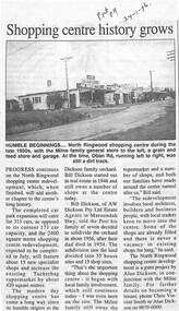
Newspaper Clipping from "The Post", 24-1-1996. P9. Shopping centre history growsProgress continues on the North Ringwood shopping centre redevelopment, adding shops and extra parkinbg spaces. The Milne and Dickson families are still involved in the shopping centre, since the land had its beginning as an orchard -
Port Melbourne Historical & Preservation Society
Plan - Proposed footbridge over the Lagoon, Bridge Street, Port Melbourne, 1863
Plan of proposed footbridge over the Lagoon in line of Bridge StreetIn ink on reverse, two small drawings: elevation land view over a distance of 25.00 chains (colour tinted), and Plan view, section of an unidentified street:In pencil on reverse, notation '107 Albert Street'sandridge lagoon, robert h morgan -
 Bendigo Historical Society Inc.
Document - MANUSCRIPT: THE ''HISTORY OF OLD INGLEWOOD'' (NO ACTUAL TITLE)
Thirty paged manuscript re the ''History of old Inglewood'' (No actual title or stated author. The 'Preface' (last page) states that in 1961 the town would celebrate its centenary and, also, that it lost its official identity (amalgamation with the Shire of Korong). Comprises:Introduction; Aboriginal life and early history of interaction with settlers; Major Mitchell exploration in area (''Yarrayne'' as name given for the Loddon; Mt Korong - aboriginal ''Barrabungale''); Pioneers on the Loddon - land tenure (Order of Council 1847), ref to Simson (Donald Campbell; Hector Norman); Charlotte Plains (run); John Catto (of Loddon) and John Catto (of Berlin); William Allen; Alexander Moffat Allen; Mr Sellars; 1852 gold rush to Mt Korong (surface); 1859 discovery of gold at Inglewood ( A J Thompson, T Thompson, T Harvey); detail of gold mining in Inglewood; Borough of Inglewood (1863); growth of the town - hotels, banks, newspapers; 1863 fire in township; fire brigade at Inglewood; selection of land; the ''Land Convention''; the ''Duffy Act''; land selection; 'modern' developments in Inglewood(rail, gas); Jack Donaldson - runner 100 yds sprint title; armed services involvement of Inglewood (WW1 & WW2); government departments.inglewood, history, early history, lodden, mt korong, donald campbell, hector norman, inglewood fire brigade, duffy act, jack donaldson, alexander moffat, john catto, major mitchell, ww1, ww2. aboriginal life, order of council 1947. -
 Bendigo Historical Society Inc.
Document - H. A. & S. R. WILKINSON COLLECTION: CONTRACT OF SALE
Contract of sale dated 14th December, 1959 between Messrs. K. R. & K. S. Johnson (vendor) and Mr. T. E. Turner (purchaser). Solicitor for vendor: Hyett, Willis & Hyett, Bull Street, Bendigo. Solicitor for purchaser: Tatchell, Dunlop, Smalley & Balmer, Williamson Street, Bendigo. Property 189-191 Mitchell Street, Bendigo, being land coloured red on the map in the margin of the title part of Crown allotment 8 section 51C, being land described in certificate f title volume 6511 folio 146, together with right of carriage way over the ponds coloured brown on the said map, and together with a right to use land coloured yellow on the said map for party wall purposes together with the use of the wall which was on the 11thOctober, 1905 standing on the said land coloured yellow. Price undisclosed. Attached: business card Hillier Parker, 6 hand written notes and drawing, 1 statement pursuant to section 34 of the estate agents act 1956, 1 cover note from the united insurance company, 2 copies of engagement or appointment in writing pursuant to section 33 of the estate agents act, 1956.organization, business, h.a. & s.r wilkinson real estate -
 Bendigo Military Museum
Photograph - 4th Field Survey Squadron – Operation ARIGHT 93, Queensland, 1993
This is a set of 42 photographs taken during 4th Field Survey Squadron’s deployment on Operation ARIGHT 93 in North Queensland from the 30th of August to the 8th of October 1993. The Survey Field Completion area of operations was Weipa near the top end of the Cape York Peninsula. Survey parties conducted field checking of topographic maps covering Bamaga, Heathlands, Weipa, Lockhart River and Strathgordon in Perentie 110 Series Survey variant FFR Land Rovers. Hand-held Trimble and Magellan GPS receivers were used to assist with navigation and to position remote isolated features. Three Bell Kiowa LOH helicopters provided by 162 Recce Sqn supported field checking operations. Supplementary and Vital Asset Protection photography was taken by air camera operators in AAAvn Nomad aircraft from 173 Survl Sqn fitted with an RC10 aerial camera.This is a set of 42 photographs taken in 1993 durin8g 4th Field Survey Squadron’s deployment on Operation ARIGHT in North Queensland. The colour photographs are on 35mm negative film and are part of the Army Survey Regiment’s Collection. The photographs were scanned at 96 dpi. .1) - Photo, colour, 1993. Survey party in Perentie 110 Series Land Rover navigates through Cape York Peninsula sand hills. .2) - Photo, colour, 1993. Cape York Peninsula sand hills. .3) - Photo, colour, 1993. Cape York Peninsula Island. .4) - Photo, colour, 1993. Survey party in Perentie 110 Series Land Rover enters a Cape York Peninsula beach. .5) - Photo, colour, 1993. SPR Kim Baker takes a break on a Cape York Peninsula beach. .6) - Photo, colour, 1993. L to R: MAJ Andy Cordova (USA Exchange) from the Army Survey Regiment and unidentified civilians. .7) to .14) - Photo, colour, 1993. Cape York Peninsula topography. .15) - Photo, colour, 1993. Unidentified surveyor in Bell Kiowa LOH helicopter. .16) - Photo, colour, 1993. Bell Kiowa LOH helicopter circles base camp. .17) to .18) - Photo, colour, 1993. Cape York Peninsula topography. .19) - Photo, colour, 1993. Vehicle convoy taking a break. L to R: LT John Bath (Detachment OC), unidentified (x2), SPR Chris Pearse. .20) - Photo, colour, 1993. Vehicle convoy taking a break. .21) - Photo, colour, 1993. Vehicle convoy ready to go. SPR Chris Pearse. .22) - Photo, colour, 1993. Vehicle convoy on the move. .23) - Photo, colour, 1993. Cape York Peninsula topography. .24) - Photo, colour, 1993. Unidentified personnel. .25) - Photo, colour, 1993. SGT Neale ‘Tex’ Houston. .26) - Photo, colour, 1993. Ground below a Bell Kiowa LOH helicopter .27) - Photo, colour, 1993. L to R: SPR Mark Sinderberry and CPL Stuart Adrain in a Bell Kiowa LOH helicopter. .28) & .29) - Photo, colour, 1993. Ground below a Bell Kiowa LOH helicopter. .30) - Photo, colour, 1993. Base camp viewed from a Bell Kiowa LOH helicopter. .31) - Photo, colour, 1993. Cape York Peninsula topography in recovery after burn-off. .32) & .33) - Photo, colour, 1993. SPR Kim Baker contemplates crossing this bridge in his Land Rover. .34) - Photo, colour, 1993. SPR Kim Baker takes a break next to a billabong. .35) - Photo, colour, 1993. Survey party in Perentie 110 Series Land Rover crosses a creek. .36) - Photo, colour, 1993. Cape York Peninsula bush fire in distance. .37) - Photo, colour, 1993. Survey party in Perentie 110 Series Land Rover traverses a sand hill. .38) - Photo, colour, 1993. SPR Kim Baker. .39) - Photo, colour, 1993. Cape York Peninsula bush fire. .40) - Photo, colour, 1993. Cape York Peninsula topography. .41) & .42) - Photo, colour, 1993. Cape York Peninsula sand hills..1P to .42P – There are no personnel identified. ‘1993 OP ARIGHT’ annotated on negative sleeve.royal australian survey corps, rasvy, 4 fd svy sqn, op aright 93 -
 Warrnambool and District Historical Society Inc.
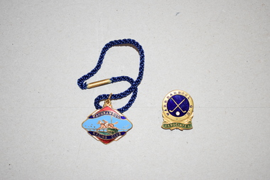
Badges (2), 1 Stokes, 1960s
These two badges came from the estate of Dorothy and Agnes Ardlie of Warrnambool. Dorothy Ardlie (1910-1993) and Agnes Ardlie (1915-1993) were the daughters of Arthur and Ethel Ardlie of Warrnambool, the granddaughters of the prominent Warrnambool lawyer, William Ardlie and his wife Mary and the great granddaughters of John and Mary Ardlie, pioneer settlers in Warrnambool. The badges appear to have belonged to Agnes Ardlie who was known to have been a keen sportswoman. The Warrnambool Racing Club was founded in the 1870s and annually produced badges for members, both men and women. Female membership of the Warrnambool Golf Club was well established by 1890 and the course then was in Albert Park. These two badges are of interest as having local provenance, belonging to a member or members of a prominent family in Warrnambool in the mid 20th century..1 This is a metal badge in an elliptical shape with gold edging. The image on the badge shows a horse and jockey clearing a hurdle with wording around the image. The colours used are blue, red, gold and green. The badge has a metal clip at the top with a blue cord attached. The back of the badge has wording imprinted on it. .2 This is an oval-shaped metal badge with an image of two golf clubs in blue and gold and the word ‘Associates’ in gold and green. On the back is a metal clip and some hand writing scratched on. The maker’s name cannot be deciphered. .1 Warrnambool Racing Club Not Transferable Season 1965-66 9 Stokes .2 Warrnambool G.C. Associates Ardlie A.A. ardlie family, history of warrnambool -
 Bendigo Historical Society Inc.
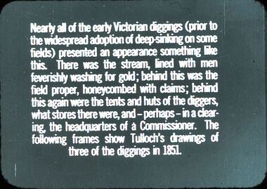
Slide - DIGGERS & MINING: THE DIGGINGS - THE DIGGERS
Diggers & Mining: The Diggings - The Diggers. Slide reads: Nearly all of the early Victorians diggings (prior) to the widespread adoption of deep skinking on some fields) presented an appearance something like this. There was the stream, lined with men feverishly washing for gold; behind this was the field proper, honeycombed with claims; behind this again were the tents and huts of the diggers, what stores there were, and - perhaps - in a clearing, the headquarters of a Commissioner. The following frames show Tulloch's drawings of three of the diggings in 1851. Markings: 2 994.LIF 6. Used as a teaching aid.hanimounteducation, tertiary, mining -
 University of Melbourne, Burnley Campus Archives
Album - Colour prints and negatives, Kodak, Preparations for 1991 Centenary Celebrations, 1990-1991
Colour photographs taken in late Spring. Includes negatives. Also extra copies in spares.(1) Administration Building. (2) Trees. (3,4) Celebration with cake. Peter Esdale 4th from left standing, Joss Tonkin (Archivist) far right standing. (5-8) Renovating Luffmann Ponds, Paula Cave, Gardener. (9) Dairy before being renovated for Centenary, known as Landscape Shed. (10) Michael Nechwatel, Handyman clearing out Dairy prior to renovation. (11-14) Renovating Dairy.administration building, trees, celebration, cake, peter esdale, joss tonkin, archivist, renovations, luffmann ponds, paula cave, gardener, dairy, centenary, landscape shed, michael nechwatel, handyman, lily ponds -
 Falls Creek Historical Society
Document - Site 4 - Design Of Extension Of Christie Street Completed
Bob (Herman) Hymans (a former member of the Royal Netherlands Navy) was born in Bloemendaal, Holland on 30th September 1922. During World War II he fought against the Japanese in the Dutch East Indies (now Indonesia) and was imprisoned in Changi and on the Burma Railway. After gaining qualifications as a Ski Instructor, Bob arrived in Falls Creek in July 1950. Working as an Instructor and Supervisor at Bogong Lodge, Bob decided his future was in accommodation. He was successful in negotiating an indenture for land from the State Electricity Commission (SEC). It took Bob two years to build his Grand Coeur Chalet but, tragically, it was burned down in August 1961. Bob also built the first Chairlift in Australia. This was a single chairlift and the structure was built from wooden electricity poles. He was constantly full of new ideas and proposals for the village. Bob Hymans died on 7th July 2007. This Collection of documents and letters tells the story of Bob's endeavours to develop Falls Creek into the ski village it is today.This letter is significant because it reflects the relationship between Bob Hymans, the State Electricity Commission and the Management Committee.A letter to Mr. Hymans' from the SEC outlining changes to be made to the land divisions in Christie Street. The intention was to create two separate sites - Site 4 and Site 4A. SIte 4 was the location of Mr Hymans' existing accommodation. He had submitted a proposal for development of Site 4A. The dimensions of each site and the proposed rentals is included in this letter. His current lease would expire on the 31st October 1964, so Mr Hymans needed to indicate what future lease arrangement he desired to pursue.falls creek tourist area management committee, bob hymans, falls creek administration -
 Orbost & District Historical Society
book, A History of the Aboriginal people of East Gippsland by Kym Thompson, January, 1985
A manuscript book with a pink cover. A History of the Aboriginal People of East Gippsland by Kym Thompson. It is a report for the Land Conservation Council, Victoria, 1985. Contains archaeological research, history of white invasion and matters related to the preservation of sites of significance in the area. 284pp.book australian-aborigines land-conservation-council thompson-kym -
Glenelg Shire Council Cultural Collection
Postcard - Postcard - Casterton, Victoria, c. 1946
SOURCED FROM CASTERTON TOWN HALL (FORMER SHIRE OF GLENELG)Black and white photo postcard. Casterton 1946 flood. Man in overalls in foreground behind barbed wire fence, several 44 gallon drums. Buildings on left, tractor towing horse float, whole area flooded, no dry land visible.Back: Purple stamp 'POSTCARD' Purple photographer's stampcasterton, flood, 1946, tourism -
Glenelg Shire Council Cultural Collection
Photograph - Photograph - aerial view of Portland, c. 1954
Black and white aerial photograph of coastline around Portland. Black border, scale all sides, 5 rows of 3 't' at regular intervals. Bottom half ocean, top half land, separated by beach, further left than 8471Front: '607 - 90 ' - handwritten, white, borderaerial photography, central portland, portland harbour, south west coastline -
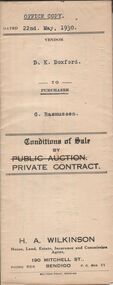 Bendigo Historical Society Inc.
Document - H.A. & S.R. WILKINSON COLLECTION: CONDITION OF SALE
Conditions of sale by private contract dated 22nd May, 1930 between D.K Doxford (seller) and G. Rasmussen (buyer) for land situate in Charles Street, Bendigo, together with 5-roomed weatherboard dwelling and all sundry. Price 440 pounds.organization, business, h.a. & s.r wilkinson real estate -
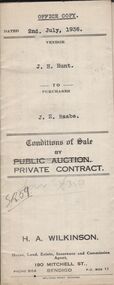 Bendigo Historical Society Inc.
Document - H.A. & S.R. WILKINSON COLLECTION: CONDITION OF SALE
Conditions of sale by private contract dated 2nd July, 1936 between J.H. Hunt (seller) and J.E. Raabe (buyer) for land situate No.7 Drought Street, together with 5-roomed weatherboard dwelling and all sundry. Price 475 pounds.organization, business, h.a. & s.r wilkinson real estate -
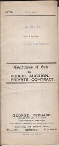 Bendigo Historical Society Inc.
Document - H.A. & S. R. WILKINSON COLLECTION: CONDITION OF SALE
Conditions of sale by private contract dated 20th. February, 1926 between R. Rigby and H. A. Wilkinson for land situate in Allingham Street, Golden Square at present occupied by vendor together with 4-roomed weatherboard dwelling for the price of 225 pounds.organization, business, h.a. & s.r wilkinson real estate -
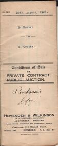 Bendigo Historical Society Inc.
Document - H.A. & S.R. WILKINSON COLLECTION: CONDITION OF SALE
Conditions of sale by private contract dated 10th. August, 1928 between S. Hunter and G. Coates for land at the corner of Clark and Haman Streets, Bendigo together with water pipes, W.C. and all sundry for the price of 27 pounds and 10 shillings.organization, business, h.a. & s.r wilkinson real estate