Showing 23747 items
matching sardine-creek
-
 Bendigo Historical Society Inc.
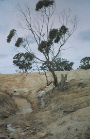
Slide - KURTING, Dec 1968
Slide. Kurting. Young man standing beside a small creek near a gum tree , near the construction site.slide, bendigo, kurting., kurting. -
 Hume City Civic Collection
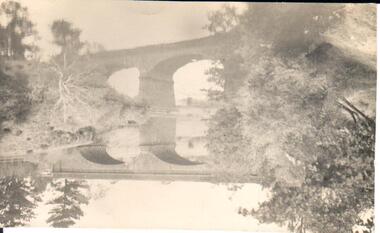
Photograph
A black and white photograph of a bluestone arched bridge over Jackson Creek in Macedon Street. Taken at Easter 1934.on back: written in pen; Bridge @ Sunbury / Easter 1934cullinan, uraina, eileen, sunbury, jackson creek, macedon street, bulla, bridges, bluestone bridge, 1930s, george evans collection -
 Lakes Entrance Regional Historical Society (operating as Lakes Entrance History Centre & Museum)
Postcard
Black and white postcard showing two horse drawn wagons crossing Bunga Creek on old Bunga roadwaterways, islands, buildings -
 Clunes Museum
Photograph
COLOUR PHOTOGRAPH AREA NEAR CREEK PREPARED AND TREES PLANTED DURING EARLY DAYS OF CLUNES GUN CLUBlocal history, photography, photographs, gun club -
Clunes Museum
Booklet, MELBOURNE WALKING CLUB, THE MELBOURNE WALKER, 1977
MELBOURNE WALKING CLUB GUIDE TO WALKINGBOOKLET: IMAGE OF PEOPLE CAMPING ALONG THE SIDE OF A CREEK, PITCHED TENT IN THE FOREFROUND ON THE FRONT COVER 80 PAGESnon-fictionMELBOURNE WALKING CLUB GUIDE TO WALKINGreference, booklet, guide book -
 Clunes Museum
Photograph, CIRCA 1859
NEGATIVE OF THIS PHOTO IS AT LATROBE LIBRARY, LATROBE STREET, MELBOURNE. THE PHOTO WAS GIVEN TO THE MUSEUM BY MR.F.C.WEICKHARDT, 1970.A PHOTOGRAPH OF THE PORT PHILLIP MINE BATTERY TAKEN FROM NO.3 CAMP PARADE, CLUNES, OPPOSITE SIDE OF CREEK.local history, photography, photographs, mining -
 Clunes Museum
Photograph
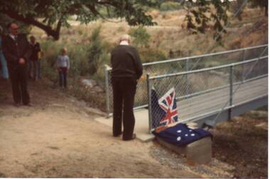
FRANK COLLINS, PRESIDENT C.T.D.A CUTTING RIBBON TO OPEN SUSPENSION BRIDGE ACROSS CRESWICK CREEK CLUNES 14.4.1986local history, photography, photographs, bridges -
 Clunes Museum
Photograph
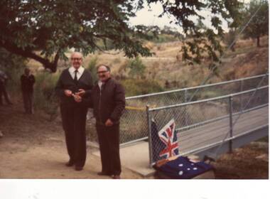
C.T.D.A. PRESIDENT, FRANK COLLINS AND UNKNOWN PERSON DURING OPENING OF SUSPENSION BRIDGE OVER CREAWICK CREEK, CLUNES.local history, photography, photographs, bridges -
 Clunes Museum
Photograph
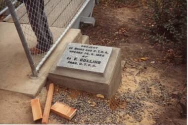
THE PLAQE AT THE SUSPENSION BRIDGE ACROSS CRESWICK CREEK OPENED BY FRANK COLLINS PRESIDENT C.T.D.A. 13/4/1986local history, photography, photographs, bridges -
Whitehorse Historical Society Inc.
Book, Archaeological Excavation, 2000
An archaeological excavation of Mitcham Road Creek CrossingAn archaeological excavation of Mitcham Road Creek Crossing 9H7922-0229), Mitcham, Victoria. October 2000. Project no 1881.An archaeological excavation of Mitcham Road Creek Crossing archaeological sites, historic buildings, mitcham road, mitcham, roads and streets, vicroads -
 Whitehorse Historical Society Inc.
Article, Burwood Link Pedestrian Bridge, 2018
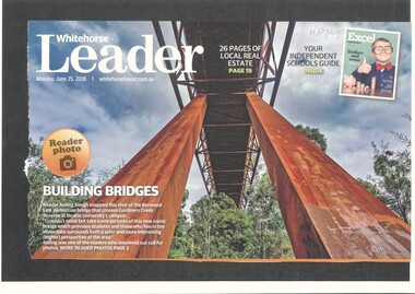
Sketch map of location of potteries in the area bounded by Middleborough, Springfield, Mitcham Roads and Burwood Highway.Photograph of the Burwood Link Pedestrian Bridge at Gardiners Creek Reserve provided by Whitehorse Leader reader Aisling Keogh.Sketch map of location of potteries in the area bounded by Middleborough, Springfield, Mitcham Roads and Burwood Highway.deakin university burwood campus, burwood link pedestrian bridge, gardiners creek reserve -
 Whitehorse Historical Society Inc.
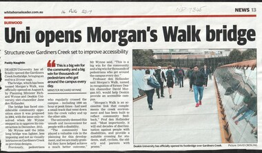
Article, Uni Opens Morgan's Walk Bridge, 2017
Deakin University has opened the Gardiner's Creek footbridge, called Morgan's Walk ending a 13 year saga.deakin university burwood campus -
Ballarat Heritage Services
Photograph - Colour, Clare Gervasoni, Seventh Street, Hepburn Springs, 2015, 25/08/2015
Colour photograph showing a block of land about to be built on at the Spring Creek side of Seventh Street in Hepburn Springs.hepburn springs -
Lakes Entrance Regional Historical Society (operating as Lakes Entrance History Centre & Museum)
Postcard, 1930 c
Also three small black and white postcards taken from same viewing point Metung donated by Peter Harper 04462.1, 04462.2, 04462.3Black and white postcard of timbered shore of Chinamans Creek looking south towards Bancroft Bay Metung Victoriaroads and streets -
Lakes Entrance Regional Historical Society (operating as Lakes Entrance History Centre & Museum)
Photograph, Lakes Post Newspaper, 1/04/1994 12:00:00 AM
Black and white photograph showing Sue Gilliland on DeRay in action during the Salt Creek Campdraft Johnsonville Victoriasports -
 Southern Sherbrooke Historical Society Inc.
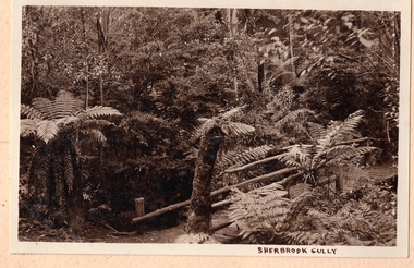
Photograph, Sherbrooke Gully
Fern gully in Sherbrooke Forest. A bridge with long log sides crosses a creek. Tree ferns edge the track. -
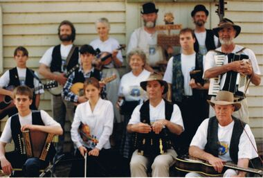
 Bendigo Historical Society Inc.
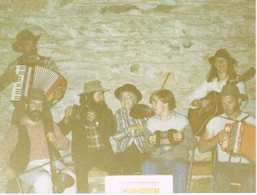
Photograph - PETER ELLIS COLLECTION: EMU CREEK BUSH BAND
Colour photograph. Quite faded. Emu Creek Bush Band. Piano accordion. Concertina. Violin. Guitar. Accordion.photo, group, emu creek bush band -
 Bendigo Historical Society Inc.
Photograph - PETER ELLIS COLLECTION: EMU CREEK BUSH BAND
Black and white photograph. White edges. Discolouration across photo. Peter Ellis. Emu Creek Bush Band.entertainment, music, emu creek bush band -
 Bendigo Historical Society Inc.
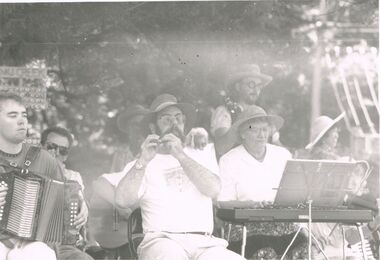
Photograph - PETER ELLIS COLLECTION: EMU CREEK BUSH BAND
Colour photograph. Emu Creek Bush Band. Instruments. Back of photo reads: Photo shoot - 1st CD.entertainment, music, emu creek bush band -
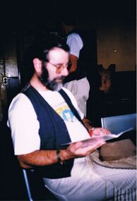 Bendigo Historical Society Inc.
Photograph - PETER ELLIS COLLECTION: MAN SITTING
Colour photograph. Man sitting looking at booklet. Quite out of focus. Emu Creek Bush Band shirt.photo, person, male -
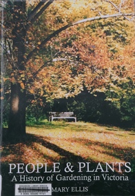 Kew Historical Society Inc
Book, Mary Ellis, People & Plants: A history of gardening in Victoria, 2003
Fish Creek., Victoria : Mary Ellis : c2003 172 p. : ill.(some col.)., ports. : 30 cm. non-fictiongardening - victoria - history, mary ellis, gardens -- victoria -- history., gardeners -- victoria -- biography. -
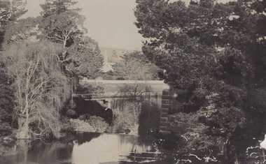 Sunbury Family History and Heritage Society Inc.
Photograph, c 1910
The photograph was taken from the iron bridge on the Rupertswood Estate. The tower of the Rupertswood Mansion can be seen in the distance. The Eadie family were business people and millers in Sunbury.A post card featuring a dark sepia image of a creek with a large house in the distance. There is a hand written message on the back.Written on the back: Dear old boy Many happy returns of the 8th. I . . . . . . . . . . . . making the . . . .Yours ever Will. Iron bridge at Rupertswood. Mr Hal Eadie Dannevirke NZ.rupertswood mansion, jacksons creek -
Stawell Historical Society Inc
Memorabilia - Realia, c1800's
Barnes Honey Jar 18 oz net. Found in Creek between Brunel & Railway Street Great Westernstawell -
 Tarnagulla History Archive
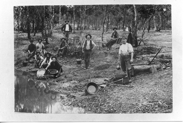
Photograph, Gold panners, Tarnagulla, 19th Century
Donald Clark Collection. A monochrome photograph depicting men panning for gold at a stream of water, probably at Sandy Creek (Tarnagulla). Copy photograph. -
City of Kingston
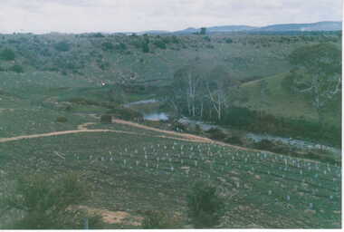
Photograph - Colour, c. 1993
Patterson Lakes is a suburb in the City of Kingston that is built one kilometre upstream of the mouth of the Patterson River. The area is bordered by the Patterson River and Eel Race Drain which enters the Kananook Creek. The suburb consists predominantly of newer housing developments and the tidal canal system of the development joins Port Phillip Bay.Patterson Lakes and the Kananook Creek were previously part of the extensive Carrum Carrum Swamp. The area was once a source of fish and eels for the Mayone-Bulluk clan of the Bunurong people. Over time the area was drained and in 1973 investigations commenced into the development of a unique residential area that would be built adjacent to canals and waterways. It was originally proposed to be known as "Gladesville". The development would give the suburb's homeowners access to Port Phillip Bay "from their back door". Circa 1974, the area was rezoned from rural to residential and named Patterson Lakes. Development has been continuous since the 1970s with construction of residential housing, schools, shopping centres, marinas, a hotel and library.Laminated colour aerial photograph of the Carrum and Patterson Lakes region within City of Kingston. This 1993 image includes Patterson River Secondary College, Roy Dore Reserve, Kananook Creek and Nepean Highway. The railway line can be seen as it veers inland from Eel Race Road, Seaford. The section of Palm Beach Drive, Curlew Point Drive, Snapper Point Drive, Clipper Island and Myola Street in Patterson Lakes appears to be a recent development with many spare blocks and new houses under construction.patterson lakes, seaford, kananook creek, carrum carrum swamp, canals and waterways -
Bendigo Historical Society Inc.
Map - CORNELLA : COUNTY OF BENDIGO, 13-4-32
Map. Cornella, County of Bendigo, County of Rodney, Colbinabbin, Gobarup, Redcastle, Toolleen, Kangaroo Creek, Cornella Creek. By authority H.J. Green, Govt. Printer. Photo-Lithographed at the Department of Lands and Survey, Melbourne. 13-4-32. Price 2/-. (number 123 in map cupboard 1)H.J. Green, Govt.Printermap, bendigo, cornella -
Bendigo Historical Society Inc.
Map - HARCOURT : COUNTY OF BENDIGO, 23-3-10
Map. County of Bendigo, County of Talbot, Sutton Grange, Ravenswood, Walmer, Faraday, Castlemaine, Axe Creek, Barkers Creek, Melbourne to Echuca Railway, Victorian Water Supply in Connection with Barkers Creek Reservoir. Victorian Water Supply Reserve, Mt. Alexander State Forest. Three areas reserved for Sericulture (Silkworms). Photo-Lithographed at the Dept. of Lands and Survey, Melbourne by T.F. McGauran 23-3-10. Price 1/-. (number 101 in map cupboard 1)T.F. McGauranmap, bendigo, harcourt -
Bendigo Historical Society Inc.
Map - HEATHCOTE : COUNTY OF BENDIGO
Map. Heathcote, County of Bendigo, County of Dalhousie, Knowsley, Knowsley East, Dargile, Costerfield, Warrowitue, Tooborac, Langwornor, Argyle Station Ground, Bendigo to Heathcote to Kilmore Railway Line, Township of Heathcote, C.R.B. Main Road. Mount Ida Creek, Wild Duck Creek, Meadow Valley Creek. By Authority H.J. Green, Govt. Printer, Photo-Lithographed at the Department of Lands and Survey, Melbourne by W.J. Butson, Price 1/-. (number 91 in map cupboard 1)H.J. Green Govt. Printer.map, bendigo, heathcote -
Southern Sherbrooke Historical Society Inc.
Information folder - Menzies Creek Rural Fire Brigade
Folder containing information pertaining to Menzies Creek Rural Fire Brigade. Contents: -pamphlet, Does the hat fit?, CFA recruitment material -insert to above, containing contact details for MCRFB -newsletter, "Menzies Creek Blazer", Vols. 1-4, 227 Oct 1997-23 Dec 1998 -newsletter, "Word Back", winter/spring 2002, summer 2003 -article, "The merry men (and women) of Menzies Creek", photocopy, no source shown, dated 1980 by handmenzies creek rural fire brigade -
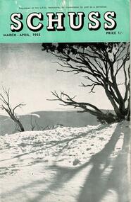 Falls Creek Historical Society
Journal - Schuss Vol. 21. No. 2 March - April 1955
Schuss was advertised as Victoria’s Official Ski Journal It was issued monthly from 1935 to 1961 except during the war when summer issues covered two months. This continued after the war, but it averaged 10 issues annually over its 25 year life. Schuss was published by the Ski Club of Victoria which had a membership of 38 Ski Clubs and demanded to be recognised as the prime authority on skiing in the state. The other 30 ski clubs with 85% of the members disagreed and the politics of skiing became heated. These clubs formed the Federation of Victorian Ski Clubs with their own journal, Ski Horizon. With the establishment of the Victorian Ski Association, Ski-Horizon published its last issue in Nov - Dec. 1955 and the role of the official journal was fully taken over by “Schuss”. This item is significant because it contains stories, images and information documenting the development of the ski industry in Victoria.The journal features stories and events chronicling developments in Victoria and internationally. Items related to the Falls Creek Area in this issue include:- Page 39 - An apology from Harold and Jean Cuming over to belief that they would have a transport tow based at Mt. Buller in the coming season. The Forestry Commission of Victoria had not approved their application. They later established a business at Falls Creek. Page 49 - Photo by S. Flattley "Spring snow conditions on the Frying Pan Spur, Fails Creek, in October, 1954."schuss journal, harold cuming, jean cuming, s. flattley