Showing 8440 items
matching dandenong
-
 Mt Dandenong & District Historical Society Inc.
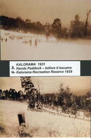
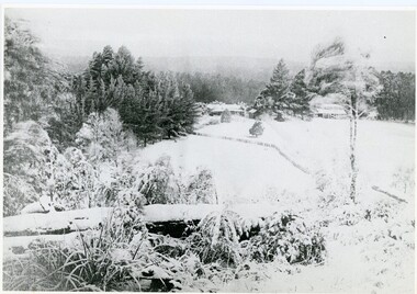
Photograph, Kalorama Snow Scenes 2 & 3, c1931
2 & 3 Snow at Hand's Paddock (Kalorama Memorial Reserve 1939) c1931.kalorama memorial reserve, snow -
 Mt Dandenong & District Historical Society Inc.
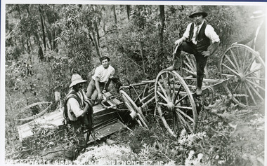
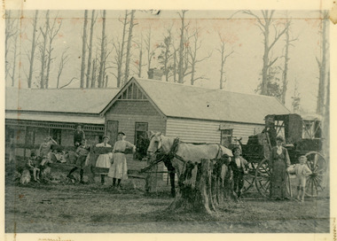
Photograph, The Wagonette Disaster 27th December 1911, 1911
This accident occurred at Devil's Elbow where now the Old Coach Road and Jasper Road meet at a cliff face. John Lundy-Clarke wrote a ballad about the mishap, probably combining fact and fancy. The wagonette was returning from an excursion to the Brooklyn Guest House in Montrose. Apparently only the horses were killed in the accident. See 'The Brooklyn Dray". The photograph shows local men inspecting the wreckage. (Not passengers as they were injured).devil's elbow, kalorama, john lundy-clarke, wagonette -
 Mt Dandenong & District Historical Society Inc.
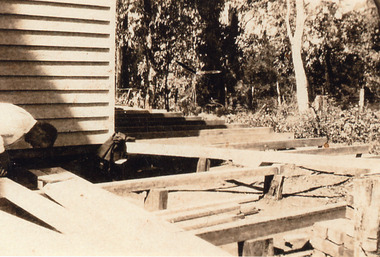
Photograph, Building Work at Kamanange, Kalorama
Close up view of unknown man working on an addition to the Robinson holiday house Kamanange.kamanange, robinson, kalorama -
 Mt Dandenong & District Historical Society Inc.
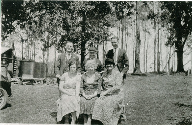
Photograph, Group at the Log Cabin
The Log Cabin Cafe was built by Jack Dodd for Miss Agnes Portelli in 1926. Miss Portelli ran the Log Cabin for many years with assistance from her niece, Evelyn Earney (nee Anstey) and other local girls. The photograph shows Evelyn Earney (LHS), Agnes Portelli (Centre) with unnamed visitors.mount dandenong, log cabin, agnes portelli, jack dodd, evelyn earney -
 Mt Dandenong & District Historical Society Inc.
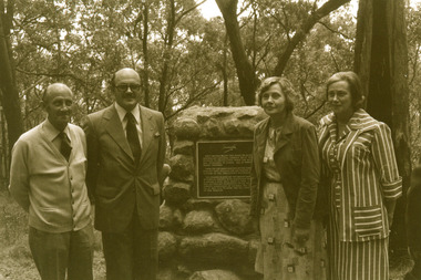
Photograph, Visitors to the site of the Kyeema Crash 1978, 1978
Three visitors at the cairn marking the site of the October 1938 crash of the aircraft Kyeema.air crash, kyeema, mt dandenong, cairn -
 Mt Dandenong & District Historical Society Inc.
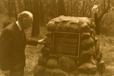
Photograph, Kyeema Crash Site Cairn 1978, 1978
Macarthur Job at the cairn unveiled at the 40 year anniversary of the crash of the aircraft Kyeema (October 1938).air crash, kyeema, cairn, mt dandenong -
 Mt Dandenong & District Historical Society Inc.
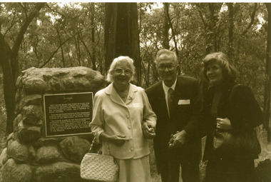
Photograph, Group at the Kyeema Aircraft Crash Cairn 1978, 1978
Family of the Hugo Gramp, who perished in the Kyeema crash, 25th October 1938, at the memorial plaque unveiled on the 40th anniversary of the disaster. L - R Mervyn Gramp, Colin Gramp, Enid Schultz, Fiona Nettlebeck. air crash, kyeema, hugo gramp, mervyn gramp, fiona nettlebeck, colin gramp, enid schultz, cairn, mt dandenong -
 Mt Dandenong & District Historical Society Inc.
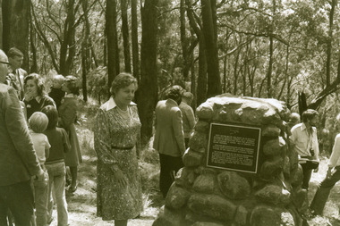
Photograph, Unveiling of the Kyeema Cairn October 25, 1978
Mrs Sybil Gramp, daughter-in-law of passenger Hugo Gramp, unveils the cairn's memorial plaque on the accident's 40th anniversary in 1978. Sybil Gramp was also a grand-daughter of one of the other victims, Mrs Elizabeth Schrader.air crash, kyeema, sybil gramp, hugo gramp, elizabeth schrader, cairn, mt dandenong -
 Mt Dandenong & District Historical Society Inc.
Photograph, The Settlement of Harmony Vale 1913, 1913
View of the settlement of Harmony Vale taken in 1913 with the guest house Kia Ora, built by George Barber in 1909, in the foreground. This photograph has a detailed inscription on the back handwritten by John Lundy-Clarke.The settlement of Harmony Vale 1913. The large home in foreground is the Guest House “Kia Ora” owned by George Barber on Lot 25 of the Village Settlement. The house above it to the left was Richardson’s house. The home of Jeanie who had left it when the picture was taken.The buildings furthest to the right of “Kia Ora” were the homestead of Isaac Jeeves of 1863 – 1871 the building furthest right with the black opening in it was the house with the tree fern floor. The flat ground above and left of Isaac’s pointed roof barn is where the creek changed its course in the 1934 flood and destroyed £4000 worth of the Rowse family’s tulip bulbs. Above the flat is Francis Matthew Child’s homestead, in the creek to the right of which can be seen the horizontal structure of the swing bridge to the sawmill of the Childs Bros which cannot be seen but in the forest to the right of the mill (bridge) can be seen a number of logs in the mill yard. The two cleared strips immediately behind Childs home were the Richardson’s original holdings and the house in the gully at the far side of the great clearing is that of the guest house “Glenrivers” belonging to W Lucas and his wife Catherine nee Child. The Richardson homestead “Harmony Vale” is behind the forest trees in the right centre. The picture gives a full view of how the settlement was cut into the centre of the great forest. george barber, kia ora, harmony vale, barber, jeanie richardson, richardson, child, matthew child, kia-ora guest house, guest house, glenrivers -
 Mt Dandenong & District Historical Society Inc.
Photograph, Jasper Road Near Erith Lane 1920, 1920
View of Jasper Road, near Erith Lane taken in 1920. The road is tree lined with two significant gum trees in the foreground. This photograph has a detailed inscription on the back handwritten by John Lundy-Clarke in 1974.Jasper Road near Erith Lane 1920. This road has only a narrow right of way. It was put in as a road to serve “Cherry Farm”, connecting it to the Coach Road at the Elbow in 1904. It joins a wide surveyed road running from Inverness Road to the Coach Road at the Elbow and could possibly have been surveyed by Thomas Hand at the same time as Inverness Road. The name Jasper now applies to full length between Erith Lane and Coach Road. McGivern Bros widened it in 1937 and J L Clarke removed and stored much of the rock quarried in the widening. This was later sold to Dick Moorby who sold it to the builders of St Michaels Church in Falls Road. Comment by John Lundy-Clarke 10.5.1974 jasper road, erith lane, john lundy-clarke -
 Mt Dandenong & District Historical Society Inc.
Photograph, A View Over Mountain Grange 1921, 1921
A view of Mountain Grange Homestead built by Thomas Hand with buildings and ground covered in snow. The photograph has historical information on the back handwritten by John Lundy-Clarke in 1976.1921 A view over “Mountain Grange” from the side of Mt Kalorama above where Grange Road is now. On the left of the homestead is the avenue of pine trees under which the annual Sunday School picnic was held. On the right is the giant pine that still stands (1976) and the great barn. The separate kitchen of the homestead can be clearly seen. mountain grange, snow, john lundy-clarke, thomas hand -
 Mt Dandenong & District Historical Society Inc.
Photograph, View From George Barber's Home On Olinda Creek Towards The Gap. c1905, 1905
Black and white photograph showing view towards The Gap (Jeeves Saddle), (Five Ways) taken c1905. Detailed inscription on back handwritten by John Lundy-Clarke in 1973.1905 (c ) view from Barber’s home on Olinda Creek, towards the Gap, then known as Jeeves Saddle. Barber’s stable in foreground. “Shiloah” Complex centre right. Tait’s house in gully just left of centre. Logan’s house can just be seen under magnifier at top of same gully near line of Barber’s Road. “Kalorama” just below lowest portion of Gap skyline with Barnes (Paynters) house “Iona” to its left. Photo copied 1973. JLC. george barber, shiloah, kalorama, iona, olinda creek, the gap, jeeves saddle, tait, paynter, barber -
 Mt Dandenong & District Historical Society Inc.
Photograph, Isaac Jeeves First Home On Running Creek 1917, 1917
Enlargement of photograph taken by Norman Rowse in 1917 that shows the first home of Isaac Jeeves built at the Running (Olinda) Creek. This photograph has a detailed inscription on the back handwritten by John Lundy-Clarke in 1974.Enlargement of photo taken by Norman Rowse in 1917 of the group of buildings erected as his first home by Isaac Jeeves at the 800° contour on the Running (Olinda) Creek on Crown Allotment 925A. The small building on the right behind the pony and the fowls was Isaac’s first substantial home and was occupied in 1858 he having lived in camp on the creek as a miner since 1855. The tall building on left was barn built in the sixties and the large roof behind was the five roomed house with a tree fern floor. This last building was of blackwood entirely above the floor and was built in the early sixties. The two old homes were pulled down by the Rowses in 1918 and the tree fern floor was pulled up by Len Childs in 1933.norman rowse, isaac jeeves, len childs, running creek -
 Mt Dandenong & District Historical Society Inc.
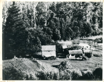
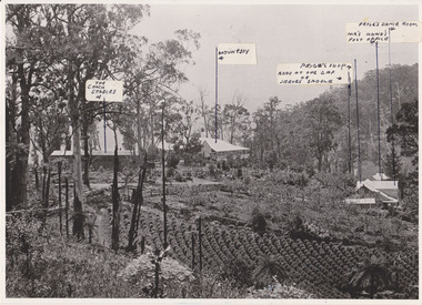
Photograph, 1908 View of Kalorama Gap From the Main Road, 1908
View of the Kalorama Gap from main Road (now Ridge Road), looking across Walker's raspberry patch with Mountjoy coaching stables on the LHS and Mountjoy Guest House in centre. Price's house and shop on the RHS.mountjoy, walker, raspberry, coach, stables -
 Mt Dandenong & District Historical Society Inc.
Photograph, 1908 View of the Kalorama Gap from Main Road With Labelling, 1908
Photograph with labels attached to front identifying buildings. View of the Kalorama Gap from main Road (now Ridge Road), looking across Walker's raspberry patch with Mountjoy coaching stables on the LHS and Mountjoy Guest House in centre. Price's house and shop on the RHS. This photograph has a detailed inscription on the back handwritten by John Lundy-Clarke in 1974.1908 View of the Kalorama Gap from main Road – now Ridge Road above Lot 2 of the Village Settlement. Looking across Walker’s raspberry patch with “Mountjoy” coaching stables on left. “Mountjoy” in centre. Prices house and shop on right with Hands “Beulah Tearooms” above Prices roof. On hillside beyond Hand’s is the slope now taken up by Kalorama Terrace. Walker’s well, then newly dug is in lower right hand corner below the tree fern head. Mt Kalorama is the hill top right. Track leaving Main Road left is Walker’s entrance drive.kalorama, kalorama gap, walker, beulah tea rooms, price, hand, mountjoy, mt kalorama -
 Mt Dandenong & District Historical Society Inc.
Photograph, View from 'Forest Edge', 1973
Photograph taken in 1973 from the property 'Forest Edge', the home of early settler George Barber. This photograph has a detailed inscription on the back handwritten by John Lundy-Clarke in 1973.Taken November 1973 by JLC. View looking from “Forest Edge” George Barber’s old home towards Price’s Lot 18. Gap on right skyline. Broadways house centre on Lot 18. Lot 25 in foreground recently cleared by Merchant Builders. Kia Ora site centre left. forest edge, george barber, price, kia ora -
 Mt Dandenong & District Historical Society Inc.
Photograph, 'Callum House' - Bill Farndon's Guest House 1911, 1911
Front view of Callum House located on the corner of Falls and Farndons Roads. Built by Bill Farndon. In the background are trees killed by bushfires in 1897. There is a horse and buggy in the foreground. Figures standing have been identified as (from LHS) Jim Clarke, Len Farndon, Jack Clarke, Essie Farndon, Rhoda farndon, Doug Farndon, Mrs Farndon. Driver is Bill Campbell. This photograph has a detailed inscription on the back handwritten by John Lundy-Clarke in 1974.1911 “Callum House” Farndon’s guest house corner of Fall’s and Farndon’s Roads. Later “Bonvenu” and again “The Oaks”. Showing the trees killed by bushfires in 1897. Figures standing are from left – Jim Clarke, Len Farndon, Jack Clarke, Essie Farndon, Rhoda Farndon, Doug Farndon, Mrs. Farndon. Bill Campbell driving.callum house, benvenu, the oaks, essie farndon, bill farndon, rhoda farndon, bill campbell, jim clarke, jack clarke, doug farndon -
 Mt Dandenong & District Historical Society Inc.
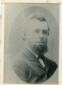
Photograph, Thomas Hand 1839-1888
Copy of a formal photograph showing head and shoulders of Thomas Hand, 1839-1888. This photograph has a detailed inscription on the back handwritten by John Lundy-Clarke in 1974.Thomas Hand 1839-1888 Surveyor for Upper Yarra Road Board 1862-1872. Engineer for Shire of Lillydale 1872-1888. Father of Kate, Eva, Eliza, Florence, Mabel, Alice, Frederick and William. Married Eliza Erith 1862. Owner of “Mountain Grange” in the present district of Kalorama. Copy of photograph in possession of his daughter Mabel made by JLC in 1974. thomas hand, mountain grange -
 Mt Dandenong & District Historical Society Inc.
Photograph, View of valley looking south over 'Kalorama' towards falls, 1908
View taken 1908 looking south over 'Kalorama', home of Ellis and Eliza Jeeves, across the valley towards the falls.This photograph has a detailed inscription on the back handwritten by John Lundy-Clarke in 1974.View taken 1908 of valley looking south over “Kalorama” towards the falls. House right of “Kalorama” was Paynter’s “Iona” on Lot 29. Faintly below line of Barber’s Road above “Kalorama” is Logan’s house on Lot 28. House against orchard was Pimm’s later Prince’s Lot 19. Big trees on right were on Price’s Lot 18 and were between Tosari Rd and Rosemont Cres. It was FROM one of these being cut up in 1931 that the round length log weighing ½ a ton got away from the splitters and raced down the hill in bounces, one of which cleared Barber’s Rd and Logan’s house in leaping from the fence line above the road.kalorama, paynter, iona, barbers road, ellis jeeves -
 Mt Dandenong & District Historical Society Inc.
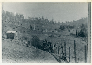
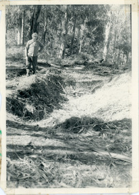
Photograph, Pit Silo 1974 view, 1974
Photograph taken in 1974 showing John Lundy-Clarke standing beside the pit silo he dug in he 1920s on Dunbar's Lot 20 of the Village Settlement. The pit silo was to hold cut maize to turn into silage for a food supply for the cows in the winter.A 1974 view of the pit silo and its maker at Lot 20 of the Village Settlement (Dunbar’s lot) The trees in the background cover the landslide of 1891-1934.pit silo, john lundy-clarke -
 Mt Dandenong & District Historical Society Inc.
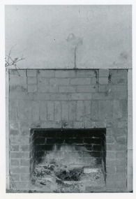
Photograph, Open Fire Place in Worker's Cottage, 1972
Photograph taken in 1972 showing an open fire place built of recycled brick in a worker's cottage. This photograph has a detailed inscription on the back handwritten by John Lundy-Clarke in 1974.Open fire place in workers cottage built of bricks from house built for John William Richardson 1897. Chimney built for Rowses by J. Lundy-Clarke May 1938. Picture taken 18-11-72 Richardsons house was pulled down by Rowse Bros. 1937-8. fireplace, richardson, rowse, john lundy-clarke -
 Mt Dandenong & District Historical Society Inc.
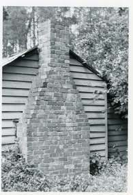
Photograph, Rowse Brothers Worman's Cottage, 1972
1972 photograph of the Rowse Brothers workman's cottage built on the bank of the Olinda Creek in 1938.This photograph has a detailed inscription on the back handwritten by John Lundy-Clarke in 1974.Rowse Bros Workman’s Cottage built in 1938 on bank of the Olinda Creek at the 800’ contour on Crown Allotment 925B of materials and bricks taken on demolishing in the same year the house built in 1897 for J.W. Richardson before his marriage to Jeanie Green and their family’s home till 1912 when they went to Queensland. Sold to Rowses in 1913 was Rowse family home till the thirties then workman’s cottage. Chimney built by J. Lundy-Clarke. Picture Dec 1972 by JLC.rowse, workman's cottage, richardson, olinda creek, kalorama, chimney -
 Mt Dandenong & District Historical Society Inc.
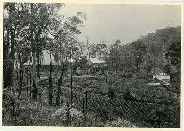
Photograph, 1913 View Over Logan's House in Village Settlement, 1913
Photograph taken in 1913 from Barbers Road showing the view down the valley. Roof in foreground is house on Bob Logan's Lot 28 in the Village Settlement. This photograph has a detailed inscription on the back handwritten by John Lundy-Clarke in 1974.1913 view over Logan’s house on Village Settlement Lot 28 taken from Barber’s Road. This is the house that the runaway log leaped over in 1930 to land far down the orchard row beyond the house. “Shiloah” is centre partly behind the clump of trees and the paddocks of Child and Richardsons pioneer selections are in the background. Link Road is centre right.logan, bob logan, robert logan, barbers road, shiloah, child, richardson, link road -
 Mt Dandenong & District Historical Society Inc.
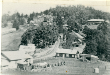
Photograph, Kalorama Gap in 1927, 1927
View of the Kalorama Gap (FiveWays) in 1927. Buildings shown are Jeeves' Garage, FiveWays Cafe, Nicholl's Store, Mountjoy. CRB Main Road, Ridge Road, Old Coach Road and barber's Road also visible. This photograph has a detailed inscription on the back handwritten by John Lundy-Clarke in 1974. The Kalorama Gap in 1927. Showing Jeeves Garage Fiveways Cafe Nicholls Store 'Mountjoy' C.R.B Main Rd Center Ridge Road Right of Center Old Coach Road lower right corner behind shed Barber's Road going left through clump of trees in center kalorama gap, kalorama, fiveways, fiveways cafe, jeeves, jeeves garage, garage, nicholls store, mountjoy, barbers road, old coach road, ridge road, main road, crb road -
 Mt Dandenong & District Historical Society Inc.
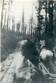
Photograph, View From Seat of Jeeves Coach, c1921
View the driver would have from horse drawn coach. CRB (Main) Road between Wombat Road and Falls Road. c1921. This photograph has a detailed inscription on the back handwritten by John Lundy-Clarke in 1974.View from seat of Jeeves Coach over horses while being driven along the new CRB road between Wombat Road and Falls Rd 1921.wombat road, falls road, crb road, jeeves coach, horse -
 Mt Dandenong & District Historical Society Inc.
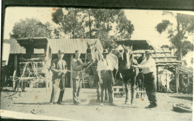
Photograph, Mountjoy Coach Yard 1920
Mountjoy coach yard 1920. Men standing with two horses are L - R Ellis Jeeves, Hubert Jeeves, Len Jones, Walter Jeeves.mountjoy, coach, stables, ellis jeeves, walter jeeves, hubert jeeves, len jones, jeeves -
 Mt Dandenong & District Historical Society Inc.
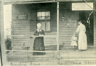
Photograph, Eliza Hand on the Verandah of her Shop 1907, 1907
1907 photoghraph of Eliza Hand (Grandma Hand), Florence Hand (Aunt Florrie) and little Gert on the verandah of the Beulah Tea Rooms at FiveWays (The Gap). This photograph has a detailed inscription on the back handwritten by John Lundy-Clarke in 1974.1907. Eliza Hand on the verandah of her shop at Kalorama gap with her daughter Florence. Opened as "Beulah Tearooms" it was made a post office in 1909 and Florence Hand became post mistress. It remained active till 1923 when, the building having been sold to Miss McPhee she built the Fiveways store alongside and moved the post office to another room. The verandah was pulled down but the room is still there (1974) facing Ridge Road at the west end of the complex. Eliza died 1918. Florence died 1968.beulah tea rooms, fiveways, the gap, florence hand, eliza hand, miss mcphee, post office -
 Mt Dandenong & District Historical Society Inc.
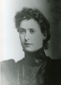
Photograph, Jeanie Richardson
Photograph of studio portrait taken of Jeanie Richardson, wife of John William (Willie) Richardson, who was the son of Jabez Richardson an early pioneer of the area. This photograph has a detailed inscription on the back handwritten by John Lundy-Clarke.Jeanie Richardson nee Green. Born 1871. Died 1916. Mother of Reuben, William, Jean. Copy of photo held by Reuben Richardson of Roma. richardson, jeanie richardson, reuben richardson, jabez richardson -
 Mt Dandenong & District Historical Society Inc.
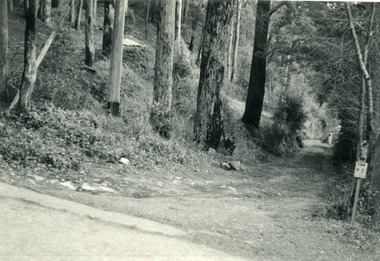
Photograph, The Wagon Road, c1970s
The old Wagon Road built 1876-1878. This photograph has a detailed inscription on the back handwritten by John Lundy-Clarke in 1974.The Wagon Road. Built 1876 – 8. The first settler’s road in the Ranges as apart from Dray Tracks. Was built through Jeeves Selection, Crown Allotment “C” named “Jeeves saddle” and removed the monopoly held over travel through the Gap. jeeves saddle, kalorama, road, wagon road, john lundy-clarke -
 Mt Dandenong & District Historical Society Inc.
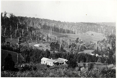
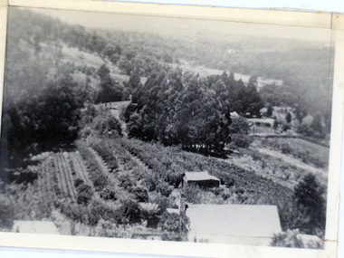
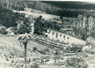
Photograph, The Valley of the Harmony Vale Settlement c1910, 1973
Scene looking across the valley of Harmony Vale from Barbers Road. c1910. Photograph copied by John Lundy-Clarke in 1973. This photograph has a detailed inscription on the back handwritten by John Lundy-Clarke in 1974.The valley of the Harmony Vale settlement on the Olinda Creek from Barbers Road. "Shiloah" on far left centre. John William Richardson's home among trees left of centre. Homestead Harmony Vale above log yard (see below) and among orchard trees. Child Bros sawmill and log yard with logs among trees above flat cultivation right of centre. Bert Childs home beyond "Harmony Vale". Lucas' "Glenrivers" is in gully above main clearing centre top left. Frank Childs home among trees centre of picture. Taken about 1910 by Rose Series. Copied 1974 JLC.kalorama, harmony vale, olinda creek, barbers road, shiloah, sawmill, child, bert child, glenrivers