Showing 10388 items
matching plan
-
 Kew Historical Society Inc
Book, Helen Baker, Historic Buildings: Windsor and Richmond, 1967
[Sydney], 1967 67 p. : illus., facsims., maps, plans ; 26 cm. non-fictionhistoric buildings - windsor (nsw), historic buildings - richmond (nsw) -
 University of Melbourne, Burnley Campus Archives
Pamphlet, Native Grasslands and Indigenous Flora Gardens
native gardens, australian native plants -
University of Melbourne, Burnley Campus Archives
Sketch, Perennial Border
Design by Geoff Olive for annual display of perennial border c. 2002 - not fully implementedgeoff olive, andrew smith, burnley gardens, perennial border -
Tarnagulla History Archive
Research file: Planning Records for Bicentennial Celebrations, Bicentennial, 1988
Donald Clark Collection A red binder containing planning records for Australia's Bicentennial celebrations held in Tarnagulla. tarnagulla, bicentennial, community celebrations, commemorations -
 Melbourne Legacy
Document, Annual ANZAC Commemoration preparations 1989, 1989
Details of discussions of the annual Anzac Commemoration Ceremony for Students with the Department of Education in 1989 regarding the 1990 ceremony. The ceremony provides a valuable opportunity for students to gain an appreciation of the Anzac spirit, the significance of the Shrine and the meaning of Anzac Day.A record of planning undertaken for the annual ceremony at the Shrine for school students by the Commemoration committee. Also that it was part of an original archive set up with S17 being document number 17 in the 'Shrine' archive.Minutes of a meeting and memo regarding planning for the Annual Anzac Commemoration Service for Students.Handwritten in blue pen 'TV coverage / S17'anzac commemoration for students, wreath laying ceremony -
 Warrnambool and District Historical Society Inc.
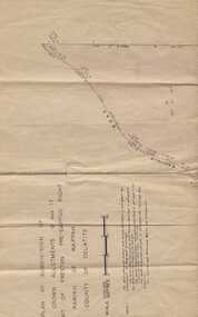
Subdivision plan, Part of Preston Estate Parish of Wappan
This map possibly relates to land of John Bostock at Preston, Delatite. Part of a collection of papers relating to the Bostock family one of the earliest pioneering families in Warrnambool.Cream coloured map printed in black with sections coloured in pink. Plan of subdivision of part of crown allotments 15 and 17 and part of Preston pre- emptive right, Parish of Wappan, County of Delatite.warrnambool,bostock,augustus bostock map, delatite map,district of wappan map, -
Clunes Museum
Drawing, ALF LOWTHER, CRUSHING WORKS PORT PHILLIP COMPANY, UNKNOWN
PHOTOCOPY OF A DRAWING OF THE CRUSHING WORKS OF THE PORT PHILLIP COMPANY, CLUNESON REVERSE: HANDWRITTEN ON REVERSE OF PLAND "PORT PHILLIP MINE, PHOTOCOPY OF DRAWINS ALF LOWTHER BENDIGO" PRINTED ON FRONT PLAN L812port phillip mine, plans, crushing works -
 University of Melbourne, Burnley Campus Archives
Plan, Pruning Garden, 1985-1995
Set of Concept Plans for the design of a Pruning Garden in the Field Station. (1) Pencil drawing on tracing paper, "Pruning Garden Field Station." (2) On tracing paper, "Concept Plan Pruning Garden Field Station VCAH Burnley 25.03.1995 by "JK". (3) 3 copies of (2) on paper. (4) 4 reduced size copies with some annotation. (5) Typed list, "Plants for Pruning Garden." (6) Tracing paper copy, Pruning Garden VCAH Burnley, Aug 1985. Scale 1: (7) Hard copy of (6).pruning, field station, vcah, burnley, gardens -
University of Melbourne, Burnley Campus Archives
Plan, 25 Wakanui Street, 1996
Plans for a garden at 25 Wakanui Street by Holmes Design. (1) Point Location Data showing plumbing fixtures. (2) Tracing paper and paper copies Dwg No 13 Site Inventory & Analysis 4/6/96. Scale 1:100. (3) Coloured tracing paper and paper copies, Dwg No 15 Preliminary Plan 6/6/96. Scale 1:100. (4) Tracing paper and paper copies Dwg No 16 Section View Backyard 6/6/96. Scale 1:50. (5) Photocopy of Certificate of Title and Sewerage.wakanui street, holmes design -
 Bendigo Historical Society Inc.
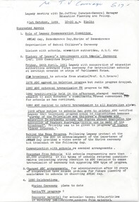
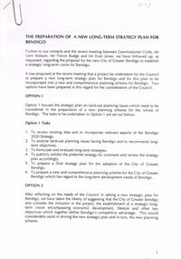
Document - VERN ROBSON COLLECTION: LONG TERM STRATEGY PLAN FOR BENDIGO
A4 document: 14 pages. document outlines long term strategy plan proposal, to feed into 2020 plan. Meeting between Commissioner Crofts, Mr. Vern Robson, Mr. Trevor Budge and Mr Evan Jones.bendigo, council, plan for strategy plan -
Bendigo Historical Society Inc.
Map - CAMPBELL COLLECTION: BENDIGO & DISTRICT MAPS, 14-6-29
Map. Eppalock, Sedgwick and Strathfieldsaye. Scale 20 chains to 1 inch. Total area 3972 acres. Prepared in W.P.B. from Assessment Plan and Parish Plans. H.A. Darby. (number 378 in map cupboard 1)H.A.Darbymap, bendigo, agricultural lands -
 Bendigo Historical Society Inc.
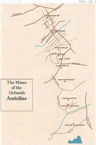
Document - THE MINES OF THE DEBORAH ANTICLINE
Plan of the mines along the Deborah Anticline: Deborah Consolidated, Deborah Associated, Deborah United, Deborah Extended, South Deborah, No. 2 shaft, Deborah North Deborah, Central Deborah, Monument Hill are all sited on the plan.Philip Wilkin, volunteer, BHSbendigo, mining, deborah line of reef -
 Bendigo Historical Society Inc.
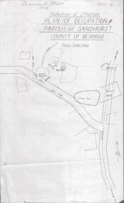
Photograph - DIAMOND HILL 1936, PLAN OF OCCUPATION
Print of 'Application of J. Hattam, plan of occupation parish of Sandhurst, County of Bendigo' Plan shows Post Office site, large dam, 'formerly cultivated site near Post Office'. A un-named gully is marked.bendigo, mining, diamond hill -
Clunes Museum
Map - CLUNES TOWN HALL AND COURTHOUSE COMPLEX, FALKINGER ANDRONAS
CLUNES TOWN HALL AND COURT HOUSE COMPLEX - PROPOSED REFURBISHMENT ARCHITECT DRAWINGS: ,1 SITE AND ROOF PLAN .2 GROUND FLOOR PLAN .3 EAST ELEVATION .4 WEST ELEVATION .5 ABC/FASSADEStown hall and courthouse drawings, proposed refurbishment -
 Melbourne Tram Museum
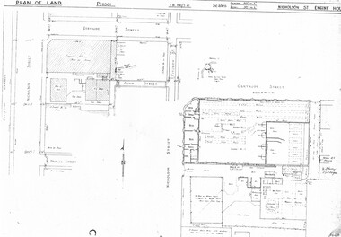
Drawing, Melbourne & Metropolitan Tramways Board (MMTB), "Nicholson St Engine House", c1938
Photocopied plans or drawings on A3 sheets of the "Nicholson St Engine House" at corner of Gertrude and Nicholson St, Fitzroy. P8501 - plan showing the location, adjacent properties and details of the Engine House - dated 3-2-1938.trams, tramways, drawings, depots, property, cable trams, engine houses, nicholson st, gertrude st -
 Bendigo Historical Society Inc.
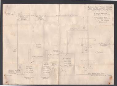
Document - BILL ASHMAN COLLECTION: CORRESPONDENCE
Detailed pencil drawn plan of the hot water system for Gifford's Mount Gambia Hotel, SA. Plan includes where Scalebuoys are situated, capacity of hot water cylinder and boilers. Also measurements of the height of taps and shower.sciences, bill ashman collection - correspondence, gifford's mount gambia hotel sa -
Port Melbourne Historical & Preservation Society
Plan - Annotated and handcoloured by Peter Libbis to indicate his research into Libbis family residences and hotels on copy of a section of an MMBW map, Melbourne and Metropolitan Board of Works, c. 1980s
Peter LIBBIS obtained these copies from the MMBW when he researched his family history in the 1980s. He has annotated them, colour in hotels etc. Donated to Society in 1997.One of a group of 19 photocopies of various 20th century MMBW plans, annotated/coloured in to indicate residences of Libbis family and local hotels, by Peter LIBBIS in family and hotel research - Beach, Nott to Dow,South of Graham - date unknownbusiness and traders - hotels, built environment - domestic, transport - railways, melbourne and metropolitan board of works, libbis family -
Port Melbourne Historical & Preservation Society
Plan - Annotated and handcoloured by Peter Libbis to indicate his research into Libbis family residences and hotels on copy of a section of an MMBW map, Melbourne and Metropolitan Board of Works, c. 1980s
Peter LIBBIS obtained these copies from the MMBW when he researched his family history in the 1980s. He has annotated them, colour in hotels etc. Donated to Society in 1997.One of a group of 19 photocopies of various 20th century MMBW plans, annotated/coloured in to indicate residences of Libbis family and local hotels, by Peter LIBBIS in family and hotel research - Railway, Montague to Ingles Street (South Melbourne mostly)business and traders - hotels, built environment - domestic, transport - railways, melbourne and metropolitan board of works, libbis family -
Port Melbourne Historical & Preservation Society
Plan - Annotated and handcoloured by Peter Libbis to indicate his research into Libbis family residences and hotels on copy of a section of an MMBW map, Melbourne and Metropolitan Board of Works, c. 1980s
Peter LIBBIS obtained these copies from the MMBW when he researched his family history in the 1980s. He has annotated them, colour in hotels etc. Donated to Society in 1997.One of a group of 19 photocopies of various 20th century MMBW plans, annotated/coloured in to indicate residences of Libbis family and local hotels, by Peter LIBBIS in family and hotel research - Princes, Graham to Liardet (portion thereof; i.e. of 671.18)business and traders - hotels, built environment - domestic, transport - railways, melbourne and metropolitan board of works, libbis family, thomas libbis -
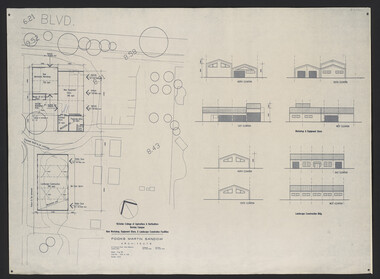 University of Melbourne, Burnley Campus Archives
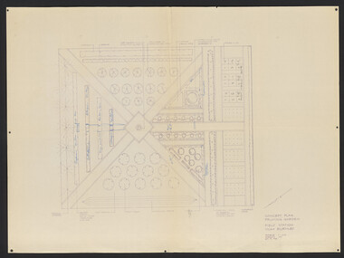
Plan, Fooks Martin Sandow Pty. Ltd, Victorian College of Agriculture & Horticulture Burnley Campus New Workshop, Equipment Store, & Landscape Construction Facilities, 1996
Plans by Fooks Martin Sandow, August 1996. Scale 1:200. (1) New Mechanics Workshop, New Equipment Store, etc. and Landscape Construction, with Elevations. (2) Layout of Equipment Store - where each piece of equipment to be placed.vcah, fooks martin sandow, equipment store, landscape construction -
Glenelg Shire Council Cultural Collection
Plan - Plans / Line Drawing Port of Portland Slipway Steel Vessel 'Cape Peron', 13/12/1989
Front: 'Bilge keel, 60" Bilge keel 62" ' - pencil on two of the line drawingsport of portland -
Bendigo Historical Society Inc.
Document - MARKS COLLECTION: SECTION OF MAIN CHANNEL
Plan drawn on waxed type paper, fragile. Written in centre of map 'Section on Centre of Main Channel , Scale horizontal 2 chs, vertical 10ft., to an inch'. Plan shows Melbourne Road on top section. Written in red ink '5,000,000 galls in 24 hours = 3472.2 gals per minute'. Plan located in documents from George Lansell auction.bendigo, mining, water channel section -
Kew Historical Society Inc
Archive (Sub-series) - Lyons, Dorothy File, Kew Historical Society, 'Ivy Grange', 1-3 Malmsbury Street, 1970
Various partiesReference, Research, InformationSecondary Values (KHS Imposed Order)Subject file containing brief notes on the history of the Ivy Grange compiled from various sources plus correspondence and planning documents relating to plans submitted to the City of Kew to alter the portico facing Malmsbury Street, Kew. These plans predated the first Kew Urban Conservation Study (Sanderson, 1988). There is also one newspaper article relating to the sale of the house in 2005.kew historical society - archives, kew - history, ivy grange - 1-3 malmsbury street - kew (vic), mansions - kew (vic), david beath (1835-1922), architects - victoria - charles vickerskew historical society - archives, kew - history, ivy grange - 1-3 malmsbury street - kew (vic), mansions - kew (vic), david beath (1835-1922), architects - victoria - charles vickers -
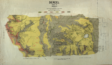 Federation University Historical Collection
Map, Dereel, County of Grenville, 1890, 1890
Dereel is in western Victoria.Geological map of Dereel in the County of Grenville featuing six colours (predominantly grey and yellow). WGS 84 Centroid Lat: 37 degrees 48 feet 50 inches S Long:143 degrees 42 feet 10 inches S N-S: 6.4 km E-W: 15.2 km dereel, ferdinand krause, crown lands department, plan -
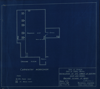 Federation University Historical Collection
Ballarat School of Mines Carpentry Workshop, 03/10/1939
carpentry workshop, plan, ballarat school of mines, k. wood -
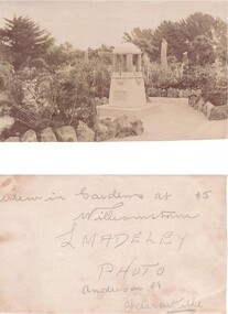 Williamstown Botanic Gardens- Hobsons Bay City Council
Postcard - Willliamstown Botanic Gardens
The original postcards in this series (2013.002 to 2013.018) were generously loaned to Williamstown Botanic Gardens by a private collector for copying. The fountain is located on the southern side of the ornamental lake and was erected to celebrate the jubilee of the municipality (17 March 1906). Controversy surrounded the commission for the design and construction of the fountain, as it was originally assigned to a contractor in Carlton. Williamstown residents insisted the fountain be designed and constructed locally, and on December 1906 the fountain was tendered by local firm Bliss and Sons and opened for public use in 1906. The fountain features a symmetrical plan, consisting of fur granite columns supporting a granite canopy and is fully operational following restoration work in 2013. The idea for the fountain came from an elderly resident of Williamstown who suggested the council follow the example of Ballarat’s gardens with its many statues and monuments. The postcards are evidence of the interest the gardens held as a subject for postcard publishers. The text and images provide a snapshot into fashions, social interests and concerns of the time. The professionally produced images provide a pictorial history of Gardens including changing planting styles, various structures and features of the Gardens eg the aviary, cannons, the fountain, the second Curator’s Lodge and gates. The images offer an opportunity to compare garden vistas with the present day. The significance of the fountain is its reflection of how Williamstown people felt for their Gardens and the importance placed on investing in locally operated business. It was noted in the Brief Jottings column of the Williamstown Chronicle, February 24 1906, the fountain is a “We favor the erection of the jubilee fountain in the Giffard-street (Williamstown Botanic) Gardens. Ornaments of that kind there will make that beauty spot even more attractive.” Sepia scene of a fountain situated on paths bordered with rocks. The fountain in on a plinth with a plaque. The fountain features a symmetrical plan, consisting of four granite columns supporting a granite canopy. High stumps of trees are just behind the fountain with larger trees in the background to the right and left of the image.Postcard, Gardens, Post-Card, Williamstown-Botanic-Gardens, Hobsons-Bay-City-Council, Jubilee-fountain, fountain drinking-fountain, granite, Bliss-and-Sons, Madeleypostcard, gardens, post-card, williamstown-botanic-gardens, hobsons-bay-city-council, jubilee-fountain, fountain drinking-fountain, granite, bliss-and-sons, madeley -
Port Melbourne Historical & Preservation Society
Plan - Annotated and handcoloured by Peter Libbis to indicate his research into Libbis family residences and hotels on copy of a section of an MMBW map, Melbourne and Metropolitan Board of Works, c. 1980s
Peter LIBBIS obtained these copies from the MMBW when he researched his family history in the 1980s. He has annotated them, colour in hotels etc. Donated to Society in 1997.One of a group of 19 photocopies of various 20th century MMBW plans, annotated/coloured in to indicate residences of Libbis family and local hotels, by Peter LIBBIS in family and hotel research - Railway yards, Ross and Clark, South Graham c 1950sbusiness and traders - hotels, built environment - domestic, transport - railways, melbourne and metropolitan board of works, libbis family -
University of Melbourne, Burnley Campus Archives
Plan, Alterations and Refurbishment of the Centen nial Display Building, 1990
Specification of workmanship and materials to be used in the construction of: Alterations and Refurbishment of the Centennial Display Building at Victorian College of Agriculture and Horticulture, Burnley for VCAH by Urban Spaces Pty. Ltd., Architects. Includes Plans and Elevations, and Presentation Drawings. Provenance Geoff C(?) 19.08.91. vcah, centennial -
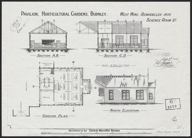 University of Melbourne, Burnley Campus Archives
Plan, Pavilion, Horticultural Gardens, Burnley, 1916
1 large and 2 identical smaller photocopies. Pavilion, Horticultural Gardens, Burnley. Elevations and Ground Plan of "West Wing Remodelled into Science Room." Stamp GB 5173. Stamp date Dec 7th 1916. From Public Records Office.pavilion, burnley gardens, burnley school of horticulture -
University of Melbourne, Burnley Campus Archives
Plan, Light Framed Lecture Theatre, 1989-1990