Showing 183009 items
matching 27-schutt-street
-
 The 5th/6th Battalion Royal Victoria Regiment Historical Collection
Container - Goblet RMR Coy
Presented to Support Company 5/6 RVR by Maj P.G Donoghue 27 Aug 1991Goblet ornate turning between base and cup. Inscribed "the RMR coy spt coy 5/6 RVR Presented by Maj P.G Donoghue 27 Aug 1991the RMR coy spt coy 5/6 RVR Presented by Maj P.G Donoghue 27 Aug 1991regimental property, rmr, 5/6 rvr, support company -
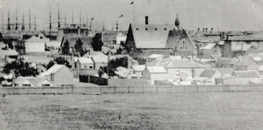
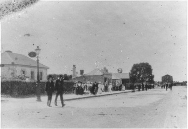 Port Fairy Historical Society Museum and Archives
Photograph
This is a rare photograph of Bank Street as there are none of the buildings shown in this photograph left standing.Black and white photograph of Bank Street early 1900’sstreet, town, bank street, sackville street, windmill -
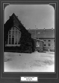 Federation University Historical Collection
Photograph - Framed Photograph, Ballarat Teachers' College
These images were hung in the corridor of the University of Ballarat School of Education (Mount Helen). It most probably dates from around the time of the transfer of the College. The Ballarat Teachers' College was established after the Victorian State Government and the State Education Department decided to establish two provincial teachers' colleges, at Ballarat and Bendigo. On 04 May 1926 W.H. Ellwood (Principal), Miss A. Bouchier, and Mr A.B. Jones, welcomed the first enrolment of 61 students to undertake the one year course. In 1927 the College moved to the former Ballarat East Town Hall in Barkly Street, which was remodelled for their use. It closed in December 1931 due to the Great Depression. In 1946 Ballarat Teachers' College reopened and relocated to the Dana Street State School. The building used by the Teachers' College was the original bluestone building facing Doveton Street South. It was originally planned to open as a women's college, for whom the residence at 130 Victoria Street was purchased, but the decision was made to admit resident men from Ballarat. Mr T.W. Turner was appointed as Principal in 1951 and directed the introduction of a two year course for the Trained Primary Teachers' Certificate. The former one year course was terminated at the end of 1951. In 1958 the College was relocated to a custom built facility at Gillies Street, in close proximity to the Ballarat Botanical Gardens. Numbers increased with the introduction of the Trained Infant Teachers' Certificate course under the guidance of Mary Egan. With the introduction of a three year Diploma Course in 1968 accommodation became cramped. The introduction of the Diploma of Teaching (Primary) led to the Trained Infant Teachers' Certificate being discontinued in 1969, and the end of the Trained Primary Teachers' Certificate in 1969. Secondary Art and Craft students began studies at Ballarat Teachers' College in 1969 under Mr Ted Doney. In 1971 Mr D. Watson was appointed Principal. The State College of Victoria was proclaimed by Order in Council on 24 July 1973, and Ballarat Teachers' College became a constituent college of the State College of Victoria, and was known as State College of Victoria, Ballarat. By 1975 the College moved to Mount Helen as part of the Ballarat College of Advanced Education. Pre service teachers currently undertake their studies on the Mount Helen Campus of Federation University. ("Ruffians Attempted to Carry of the School Tent: A History of State Education in Ballarat", 1974, p73-4.) Framed black and white photograph of: .1) the former Ballarat East Town Hall .2) the old Dana Street Primary School during the era it was used as the Ballarat Teachers' College. The photographed is surrounded by a green matboard. .3) Ballarat Teachers' College, Gillies Street.Plaque under photo "Ballarat Teachers' College Doveton Street 1926, 1946-1957 (Part of Dana Street Primary School No. 33)ballaratteachers college, dana street primary school, teacher education, 00607 -
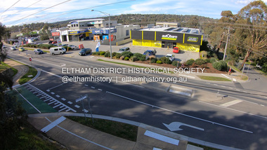 Eltham District Historical Society Inc
Photograph, Peter Pidgeon, Shops at corner of Bolton Street and Brougham Street, Eltham, 2 Aug. 2022
View looking east from Bolton Street near Brougham Street, Eltham taken from PETStock looking over the industrial area of ElthamBorn Digitaleltham, bolton steet, industry, petstock eltham central, autobarn, shops, brougham street, eltham ridge -
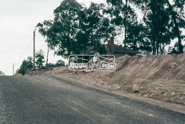 Eltham District Historical Society Inc
Slide, Looking north along Bolton Street at intersection with Godalmin Street;, Eltham, 18 July 1972, 1972
Reconstruction works by Eltham Shire Council, Bolton Street, Eltham, 18 July 1972 House visible is present day No. 1 Godalmin Street35 mm colour positive transparency Mount - Agfacolor Service (Blue)bolton steet, eltham, eltham shire council, godalmin street, infrastructure, road construction -
 Eltham District Historical Society Inc
Slide, Looking north along Bolton Street at intersection with Godalmin Street;, Eltham, 18 July 1972, 1972
Reconstruction works by Eltham Shire Council, Bolton Street, Eltham, 18 July 1972 House visible is present day No. 1 Godalmin StreetDigital panorama created from two 35 mm colour positive transparency Mount - Agfacolor Service (Blue)bolton steet, eltham, eltham shire council, godalmin street, infrastructure, road construction -
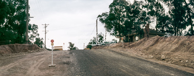
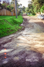
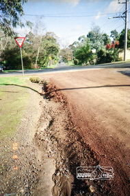
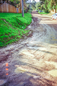 Eltham District Historical Society Inc
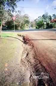
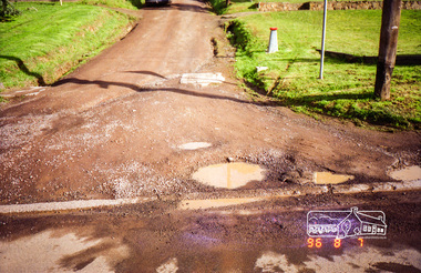
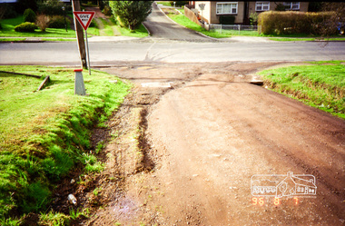
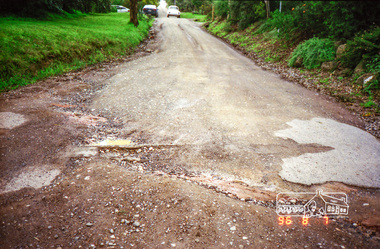
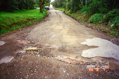
Photograph, Road surface conditions around Eltham: Looking east along Franklin Street from intersection with Bible Street, 7 Aug 1996, 1996
Shows sections of Franklin, John and Napoleon streets were still unmade as of late 1996 and the condition of those roads with potholes at the intersections with Bible Street.Reflects on the changing nature of the local street-scape and housesRoll of 35mm colour negative film, 7 stripsKodak Gold 100-5eltham, napoleon street, bible street, franklin street, john street -
 Eltham District Historical Society Inc
Photograph, Road surface conditions around Eltham: Looking west along Franklin Street at intersection with Bible Street, 7 Aug 1996, 1996
Shows sections of Franklin, John and Napoleon streets were still unmade as of late 1996 and the condition of those roads with potholes at the intersections with Bible Street.Reflects on the changing nature of the local street-scape and housesRoll of 35mm colour negative film, 7 stripsKodak Gold 100-5eltham, napoleon street, bible street, franklin street, john street -
 Eltham District Historical Society Inc
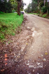
Photograph, Road surface conditions around Eltham: Looking west along John Street at the intersection with Bible Street, 7 Aug 1996, 1996
Shows sections of Franklin, John and Napoleon streets were still unmade as of late 1996 and the condition of those roads with potholes at the intersections with Bible Street.Reflects on the changing nature of the local street-scape and housesRoll of 35mm colour negative film, 7 stripsKodak Gold 100-5eltham, napoleon street, bible street, franklin street, john street -
 Eltham District Historical Society Inc
Photograph, Road surface conditions around Eltham: Looking east along John Street at the intersection with Bible Street, 7 Aug 1996, 1996
Shows sections of Franklin, John and Napoleon streets were still unmade as of late 1996 and the condition of those roads with potholes at the intersections with Bible Street.Reflects on the changing nature of the local street-scape and housesRoll of 35mm colour negative film, 7 stripsKodak Gold 100-5eltham, napoleon street, bible street, franklin street, john street -
 Eltham District Historical Society Inc
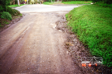
Photograph, Road surface conditions around Eltham: Napoleon Street looking east from intersection with Bible Street, 7 Aug 1996, 1996
Shows sections of Franklin, John and Napoleon streets were still unmade as of late 1996 and the condition of those roads with potholes at the intersections with Bible Street.Reflects on the changing nature of the local street-scape and housesRoll of 35mm colour negative film, 7 stripsKodak Gold 100-5eltham, napoleon street, bible street, franklin street, john street -
 Eltham District Historical Society Inc
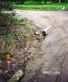
Photograph, Road surface conditions around Eltham: Napoleon Street looking west across Bible Street, 7 Aug 1996, 1996
Shows sections of Franklin, John and Napoleon streets were still unmade as of late 1996 and the condition of those roads with potholes at the intersections with Bible Street.Reflects on the changing nature of the local street-scape and housesRoll of 35mm colour negative film, 7 stripsKodak Gold 100-5eltham, napoleon street, bible street, franklin street, john street -
 Eltham District Historical Society Inc
Photograph, Road surface conditions around Eltham: Napoleon Street at Bible Street, Eltham, looking south-east, 7 Aug 1996, 1996
Shows sections of Franklin, John and Napoleon streets were still unmade as of late 1996 and the condition of those roads with potholes at the intersections with Bible Street.Reflects on the changing nature of the local street-scape and housesRoll of 35mm colour negative film, 7 stripsKodak Gold 100-5eltham, napoleon street, bible street, franklin street, john street -
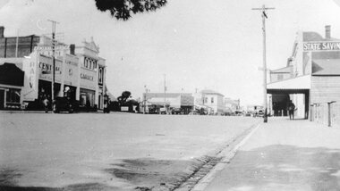 Stawell Historical Society Inc
Photograph, Main Street Stawell looking East from St Georges Street with McClure's Garage, Post Office & the State Savings Bank on right 1930
Main Street Stawell McClure's garage Post Office State Savings Bank on Right. 1930 looking East from St Georges Streetstawell businesses streetscape -
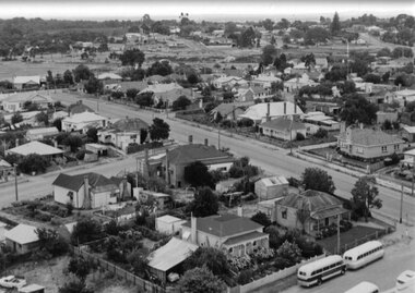 Stawell Historical Society Inc
Photograph, Panorama of Stawell from the top of St. Matthew’s Spire with the Childe Street and Wimmera Street intersection on the right
Panorama of Stawell from the top of St. Matthew’s Spire. Childe Street and Wimmera Street intersection at right of photograph. Kings Buses in right corner.stawell, streetscape -
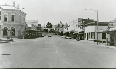 Stawell Historical Society Inc
Photograph, Main Street Stawell looking East from west of Wimmera Street
Stawell Main Street looking East from west of Wimmera Street. Post office on left Post Office Arcade on right. Vehicles in distance.stawell streetscape -
 Eltham District Historical Society Inc
Photograph, Looking down Pryor Street to Main Road, Eltham, c.1960
Eltham Plumbing Supplies (Lennie Whiteway Plumbing) located on the right side of the street. It later became the Eltham Bookshop and sold cane ware as well. On the corner with Main Road is the local branch of the State Bank of Victoria. The building still stands and is the present day Westpac bank branch. The Railway Station Master's house on opposite side was later demolished to make way for a carpark. 27 Aug 1963: Pettion for Bankruptcy re Jeanette Patricia Whiteway of 88 Napoleon Street, Eltham, house duties, and lately carrying on a business at Pryor Street, Eltham in partnership with another as a plumber under the names Eltham Plumbing Supplies and L. & J.P. Whiteway 1963 'SEQUESTRATION ORDERS AND FIRST MEETINGS', Commonwealth of Australia Gazette (National : 1901 - 1973), 12 September, p. 3259. , viewed 10 Jul 2018, http://nla.gov.au/nla.news-article241015035 Orders for discharge of bankruptcy suspended till 23 March 1967 for Leonard Whiteway and Jeanette Patricia Whiteway of 5 John Street, Eltham 1967 'NOTICE OF ORDERS OF DISCHARGE', Commonwealth of Australia Gazette (National : 1901 - 1973), 11 May, p. 2427. , viewed 10 Jul 2018, http://nla.gov.au/nla.news-article241040009Black and white photograph prints (x3) Negative (copy) 4x5 large format Black and White (x2)Shire of Elthampryor street, eltham plumbing supplies, main road, eltham, eltham bookshop, jeanette patricia whiteway, lennie whiteway plumbing, leonard whiteway, state bank of victoria, station masters house, westpac bank -
 Port Melbourne Historical & Preservation Society
Photograph - View of Port Melbourne, c.1890
.The view of Port Melbourne looking towards the sailing ships moored at Railway Pier is believed to have been taken from the Fire Tower off Liardet Street. Swallow's chimney can be seen behind the Graham Street Methodist church. This photograph is a part of a wider view of an original photograph taken for International Exhibition of 1873.View of Port Melbourne looking towards Town Pier with Swallow 's chimney behind the Graham Street Methodist Church.On back Methodist Church Graham Street Swallow's Chimney in Back groundreligion - methodist church graham street, swallow & ariell ltd, fire tower -
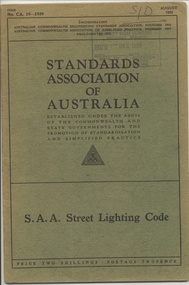 Ballarat Tramway Museum
Book, Australian Standards Association, "SAA Street Lighting Code", 1939
Book - 28 pages + slight Green covers, side stapled, issued by the Australian Standards Association, "SAA Street Lighting Code" August 1939, CAA. 19-1939 providing standards for the lighting of intersections, streets, location and mounting of lights, and the type of units.On top right hand corner has stamp of the "SEC Ballarat Branch stamp, and dated 8. Dec. 1939" and letters S/D in pencil.trams, tramways, lights, standards -
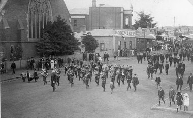 Stawell Historical Society Inc
Photograph, Street Parade in Main Street led by Stawell Band near Holy Trinity Church
Main Street. Street Parade led by Stawell Band near Holy Trinity Church. Bootmaker Mr Webster. Barker Bros Grocers. Town Hall. stawell -
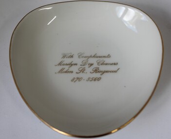 Ringwood and District Historical Society
Souvenir - Dish, small, Fine China Australia, Westminster China, Small ovoid shaped Westminster China dish - cream with narrow gold rim and gold inscription - With Compliments, Marilyn Dry Cleaners, Molan Street, Ringwood 870-8560
Small ovoid shaped china bowl - cream with narrow gold rim. +Additional Keywords: Marilyn Dry CleanersWith compliments, Marilyn Dry Cleaners, Molan Street, Ringwood 870-8560 (on base - see maker) -
 Ringwood and District Historical Society
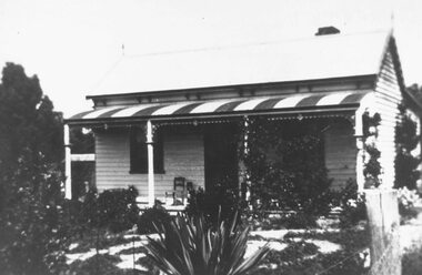
Photograph, Murfet's House, New Street. 1910
Written on backing sheet, "Murfet's House, New Street. 1910. Now Lawrence and Hansen (no date)". -
 Ringwood and District Historical Society
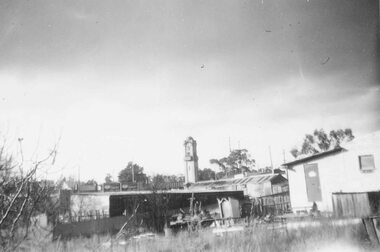
Photograph, Ringwood Clock tower from outside Presbyterian Church, Adelaide Street - 1957
Written next to photograph, "Clock tower from outside Presbyterian Church, Adelaide Street - 1957." -
 Ringwood and District Historical Society
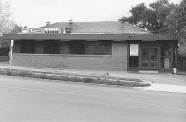
Photograph, Kenlaural Dance Studio, 35 Ringwood Street, Ringwood 1981
Written on back of photograph, "Kenlaural Dance Studio, 35 Ringwood Street. 30/9/81". -
 Ringwood and District Historical Society
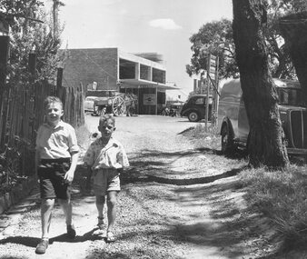
Photograph, Midway Arcade, Ringwood, being built. Lane went to Adelaide Street - 1956
2 young boys in lane (unidentified)Written on backing sheet, "Midway Arcade being built. Lane went to Adelaide Street - 1956". -
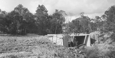 Ringwood and District Historical Society
Photograph, Bridge over Mullum Creek under construction, Oliver Street. 1963
2 photographsWritten on back of photograph, "Bridge over Mullum Creek, Oliver Street. 17/11/1963"