Showing 10708 items matching "east melbourne"
-
 Bendigo Historical Society Inc.
Document - CONNELLY, TATCHELL, DUNLOP COLLECTION: LEGAL PAPERS, 1886
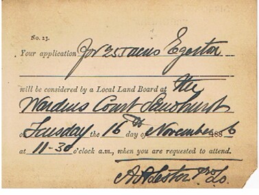
Documents. Connelly, Tatchell & Dunlop - Legal Papers. 1 - 1886 - Letter from Meudell George D re Holloway. Letterhead - Horrell & Meudell (R F Horrell & G D Meudell), Auditors, Secretaries and Accountants, 10 Market Buildings, William Street, Melbourne. 2 - 1886 - Post Office Telegraph 4 Nov 1886 for Merrifield S from Bruce T?, St Kilda asking, 'Where is Penders blackboy Pompey'. Reply from Merrifield mentions 'Pompey was remanded Melbourne on Friday last. Enquire at watch tower there.' Also mentions 'I don't know whether Mr Bruce is Pompey's friend or Caesars (Mr Penders)' on Attached handwritten note dated 4 Nov 1886. 3 - 1886 - Letter from Williams A M, Solicitor, 28 Queen Street, Melbourne re Bagot? V Budden 4 - 1886 - Post card to Suffern? Mr William James, Elmore from Lester A,A. Land Officer, re 255 acres, Egerton. Mentions Wardens Court, Sandhurst. 5 - 1886 - Letter from Drues W T, 19 Temple Court re A'Becketts fees. 6 - 1886 - Letter from Barrett Henry, Runnymede East.cottage, miners, connelly, tatchell & dunlop, meudell george d, holloway, horrell & meudell, merrifield s, bruce t?, penders, pompey, caesars, williams a m, bagot, budden, suffern mr william james, lester a a, drues w t, a'becketts, barrett henry -
 Bendigo Historical Society Inc.
Photograph - SMALL PORTRAIT PHOTOGRAPH BOY IN UNIFROM
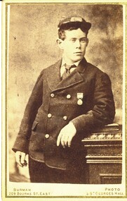
Small portrait photograph of a young male in unifrom with medal, photographer Burmans 209 Bourke St East near Parliament Houses and StGeorges hall Melbourne.Burmansphotograph, portrait, male -
 Bendigo Historical Society Inc.
Map - WANURP : COUNTY OF BENDIGO, 1-12-33
Map. Wanurp, County of Bendigo, Terrick Terrick East, Pannoobamawm, Milloo, Dingee, Mitiamo. Photo-Lithographed at the Dept. of Lands and Survey, Melbourne. Price 1/-. 1-12-33. By authority H.J. Green, Govt. Printer. (number 26 in map cupboard 1)H.J. Green, Govt. Printermap, bendigo, wanurp -
Bendigo Historical Society Inc.
Map - POWLETT : COUNTY OF BENDIGO, 2-12-15
Map. Powlett, County of Bendigo, County of Gladstone, Janiember West, Janiember East, Yarrayne, Salisbury West, Kurting, Korong, River Loddon. By Authority Albert J. Mullett, Government Printer, Melbourne. Photographed at the Department of Lands and Survey, Melbourne by W. J. Butson.2-12-15. Price 1/-. (number 119 in map cupboard 1)Albert J. Mullett, Government Printermap, bendigo, powlett -
Bendigo Historical Society Inc.
Map - BENDIGO, 1916
Map. Bendigo, Gunbower, Gladstone, Talbot, Dalhousie, Rodney, Jarklan, Calivil, Hayanmi, Mitiamo, Wanurp, Pannoobamawm, Bamawm, Millewa, Ballendella, Janiember West, Janiember East, Pompapiel, Talambe, Dingee, Milloo, Pannoomilloo, Rochester West, Yarrayne, Salisbury, Yallook, Tandarra, Kamarooka, Warragamba, Diggorra, Minto, Bridgewater, Yarraberb, Neilborough, Whirrakee, Egerton, Elmore, Nolan, Goornong, Bagshot, Huntly, Derby, Leichardt, Nerring, Tarnagulla, Woodstock, Marong, Sandhurst, Wellsford, Bendigo, Axedale, Strathfieldsaye, Eppalock, Kimbolton, Lyell, Sedgwick, Mandurang, Lockwood, Ravenswood, Shelbourne, Laanecoorie. Price 3/-. Smaller map of State of Victoria. Lithographed at the Department of Lands and Survey, Melbourne. 1916. Scale : Two miles to one inch. Map was in book form. (number 62 in map cupboard 1)map, bendigo, bendigo -
Bendigo Historical Society Inc.
Map - JANIEMBER EAST : COUNTY OF BENDIGO, 15-1-34
... Bendigo janiember east H.J. Green, Govt. Printer, Melbourne. Map ...Map. Janiember East, County of Bendigo, Jarklan, Pompapiel, Yarrayne, Powlet, Janiember West, Serpentine Creek, Caney's Blind Creek Long Plain Creek, Loddon River. By authority : H.J. Green, Govt. Printer, Melbourne. Drawn and reproduced at the Department of Lands and Survey, Melbourne, Victoria. Price 2/-. 15-1-34. (number 45 in map cupboard 1)H.J. Green, Govt. Printer, Melbourne.map, bendigo, janiember east -
Bendigo Historical Society Inc.
Map - DARGILE : COUNTY OF BENDIGO, November 1953
Map. Dargile, County of Bendigo, County of Rodney, Cornella Creek, Northern Highway, Crosbie, Redcastle, Knowsley East, Heathcote, Costerfield, Moormbool West. By authority W.M. Houston, Government Printer. Drawn and reproduced at the Department of Lands and Survey, Melbourne. November 1953. Price 2/-. (number 115 in map cupboard 1)W.M Houston, Government Printermap, bendigo, dargile -
Bendigo Historical Society Inc.
Map - CROSBIE : COUNTY OF BENDIGO, 1970
Map. Crosbie, County of Bendigo, County of Rodney, Toolleen, Weston, Dargile, Knowsley East, Redcastle, Township of Toolleen, Northern Highway, Mt.Pleasant Creek. By Authority R.H. Rixon, Government Printer, Melbourne. Drawn and reproduced at the Department of Lands and Survey, Melbourne. 1970. Price $1.00. (number 114 in map cupboard 1)R.H. Rixon, Government Printer, Melbourne.map, bendigo, crosbie -
Bendigo Historical Society Inc.
Map - CROSBIE : COUNTY OF BENDIGO, 28-9-76
Map. Crosbie, County of Bendigo, County of Rodney, Mt. Pleasant Creek, Weston, Toolleen, Redcastle, Dargile, Knowsley East. W.E. Porter, draughtsman, August 1878. Photo-Lithographed at the Department of Lands and Survey, Melbourne, J. Noune,28-9-76. (number 113 in map cupboard 1)W.E. Porter, Draughtsmanmap, bendigo, crosbie -
Bendigo Historical Society Inc.
Map - WESTON : COUNTY OF BENDIGO : COUNTY OF RODNEY, 4-5-21
Map. Weston, County of Bendigo, County of Rodney, Muskerry, Crosbie, Knowsley East, Knowsley, Axedale. Back Creek. By authority A.J. Mullett, Government Printer, Melbourne. Photo-Lithographed at the Department of Lands and Survey, Melbourne by W.J. Butson 4-5-21. Price 1/-. (number 108 in map cupboard 1)A.J. Mullett, Government Printer, Melbourne.map, bendigo, weston -
Bendigo Historical Society Inc.
Map - KNOWSLEY EAST : COUNTY OF BENDIGO, 18-112-77
Map. Knowsley East, County of Bendigo, County of Rodney, Weston, Knowsley, Crosbie, Dargile, Heathcote, Forest Creek, Shingle Hut Creek, Mt. Camel Estate, Sheep Station Creek, Mount Ida Creek. Photo-graphed at the Department of Lands and Survey, Melbourne by J. Noune 18-12-77, (number 104 in map cupboard 1)J. Nounemap, bendigo, knowsley east -
Bendigo Historical Society Inc.
Map - KNOWSLEY : COUNTY OF BENDIGO, 7-11-1941
Map. Knowsley, County of Bendigo, County of Rodney, Weston, Axedale, Eppalock, Knowsley East, Langwornor, Heathcote, Campaspe River, Mt. Ida Creek or Wild Duck Creek, Sandhurst and Heathcote Railway, Kilmore-Heathcote-Bendigo Road. Knowsley Station Ground. Shingle Hut Creek, Forest Creek. By authority H.E. Daw, Government Printer, Melbourne. Drawn and reproduced at the Department of Lands and Survey, Melbourne. 7-11-1941. Price 2/-. (number 103 in map cupboard 1)H.E. Daw, Government Printer, Melbourne.map, bendigo, knowsley -
Bendigo Historical Society Inc.
Map - KNOWSLEY : COUNTY OF BENDIGO, 21-1-19
Map. Knowsley, County of Bendigo, County of Rodney, Weston, Crosbie, Knowsley, Dargile, Heathcote, Shingle Hut Creek, Sheep Station Creek, Forest Creek, Bendigo and Wallan Railway, Mt. Ida Creek. By authority A.J. Mullett, Government Printer, Melbourne. Photo-Lithographed at the Department of Lands and Survey, Melbourne by W.J. Butson 21-1-19, Price 1/-. (number 102 in map cupboard 1)A.J. Mullett, Government Printer, Melbourne.map, bendigo, knowsley east -
Bendigo Historical Society Inc.
Map - HEATHCOTE : COUNTY OF BENDIGO
Map. Heathcote, County of Bendigo, County of Dalhousie, Knowsley, Knowsley East, Dargile, Costerfield, Warrowitue, Tooborac, Langwornor, Argyle Station Ground, Bendigo to Heathcote to Kilmore Railway Line, Township of Heathcote, C.R.B. Main Road. Mount Ida Creek, Wild Duck Creek, Meadow Valley Creek. By Authority H.J. Green, Govt. Printer, Photo-Lithographed at the Department of Lands and Survey, Melbourne by W.J. Butson, Price 1/-. (number 91 in map cupboard 1)H.J. Green Govt. Printer.map, bendigo, heathcote -
Bendigo Historical Society Inc.
Map - YARRAYNE : COUNTY OF BENDIGO, 6-1-32
Map. Yarrayne, County of Bendigo, Janiember East; Pompapiel, Salisbury, Bridgewater, Salisbury West, Powlett. Photo-Lithographed at the Department of Lands and Survey, Melbourne. Price 2/-. 6-1-32. (number 12 in map cupboard 1)H.J. Green, Government Printermap, bendigo, yarrayne -
Bendigo Historical Society Inc.
Map - WANURP : COUNTY OF BENDIGO, 1-12-33
Map. Wanurp, County of Bendigo, Terrick Terrick East, Mitiamo, Milloo, Pannoobamawm. By authority H.J. Green, Government Printer.Photo-Lithographed at the Department of Lands and Survey, Melbourne. Price 2/-. 1-12-33. (number 9 in map cupboard 1)H.J. Green, Government Printermap, bendigo, wanurp -
Bendigo Historical Society Inc.
Map - POMPAPIEL : COUNTY OF BENDIGO, 1-10-27
Map. Pompapiel, County of Bendigo, Calivil, Janiember East, Yarrayne, Salisbury, Yallook, Talambe, Judyong Creek, Bullock Creek, Pompapiel Creek, Edeyrn Estate. Photo-Lithographed at the Department of Lands and Survey, Melbourne by W.J. Butson, 1-10-27, Price 1/-. (number 4 in map cupboard 1)W.J. Butson, Government Printermap, bendigo, pompapiel -
Bendigo Historical Society Inc.
Map - PANNOOBAMAWM : COUNTY OF BENDIGO, 1957
Map. Pannoobamawm, County of Bendigo. By Appointment W.M. Houston, Government Printer, Melbourne. Drawn and reproduced at the Department of Lands and Survey, Melbourne. Price 2/-.1957. Turrumberry, Terrick Terrick East, Wanurp,Pannoomilloo, Bamawm, Pannoobamawm. (number 2 in map cupboard 1)W.M. Houston, Government Printermap, bendigo, pannoobamawm -
Port Melbourne Historical & Preservation Society
Plan - Inner East, Ferry Terminal, Station Pier, Port Melbourne, Engineering Division, Port of Melbourne Authority, 1983
Plan - General arrangement - Station Pier - Inner East - ferry terminalmelbourne harbor trust - port of melbourne authority -
Port Melbourne Historical & Preservation Society
Plan - New gantry, Inner East, Ferry Terminal, Station Pier, Port Melbourne, Engineering Division, Port of Melbourne Authority, 23 Apr 1985
Plan - General arrangement of new gantry at Station Pier Inner East Ferry Terminalmelbourne harbor trust - port of melbourne authority -
Port Melbourne Historical & Preservation Society
Plan - Operation geometry of gantry, Inner East, Ferry Terminal, Station Pier, Port Melbourne, Engineering Division, Port of Melbourne Authority, 27 May 1985
Plan - Operation geometry of gantry at Station Pier Inner East Ferry Terminalmelbourne harbor trust - port of melbourne authority -
Port Melbourne Historical & Preservation Society
Plan - Operation geometry of temporary gantry, Inner East, Ferry Terminal, Station Pier, Port Melbourne, Engineering Division, Port of Melbourne Authority, 20 May 1985
Plan - Operation geometry of temporary gangway at Station Pier Inner East Ferry Terminalmelbourne harbor trust - port of melbourne authority -
Port Melbourne Historical & Preservation Society
Map - MMBW, 1895
MMBW 1895 Plan No's. 344 to 349 Segment: Ingles to Bridge, Nott to Esplanade East (on south) Scale 40ft=1" (large)311/H 22melbourne and metropolitan board of works, port melbourne town hall, built environment, business and traders - hotels -
Port Melbourne Historical & Preservation Society
Postcard - Railway Pier, Port Melbourne, 1914
Collected by Alison Kelly when she was caretaking the Missions to Seamen Building 1987-90.One of six postcards, mostly various angles and times of Railway Pier, Port Melbourne. Hand tinted view of east side of Railway Pier, two steamers, one paddlesteamer and train at right.piers and wharves - railway pier -
Port Melbourne Historical & Preservation Society
Photograph - Gasworks demolition, 1979
Six small photographs of gasworks demolition in about 1979 1. Lagoon, Esplanade East, boundary of Lagoon Reserve 2. Upright crash frame 3. Mangled cranes 4. Graham st 5. Fallen crane 6. Fallen cranebuilt environment - industrial, utilities - gas, gasworks, demolition, sandridge lagoon, lagoon reserve -
Port Melbourne Historical & Preservation Society
Photograph - Resiting eastern kiosk, Station Pier, Port Melbourne, Ron Laing, 1993
The kiosk was turned sideways to make room for the TT Lines truck park. It was later extended to the east to create a 90 seat restaurant, known at the turn of the century as Cafe Limani. Part of Ron Laing's collection of photographs taken around Port Melbourne over a thirteen year period. Donated to the PMH&PS by the photographer.A set of 18 colour photographs showing the re-siting of the eastern kiosk on Station Pier (later Cafe Limani) c 1993piers and wharves - station pier, ron laing -
Port Melbourne Historical & Preservation Society
Photograph - Demolition east wing (finger pier) and construction of truck bay and ramp for Abel Tasman and Spirit of Tasmania, Station Pier, Port Melbourne, Ron Laing, 1986 - 1999
Part of Ron Laing's collection of photographs taken around Port Melbourne over a thirteen year period. Donated to the PMH&PS by the photographer.A set of fifty-three colour photographs c1992 covering the demolition of the east wing or finger pier of Station Pier, and construction of the new truck bay and ramp for the Abel Tasman and Spirit of Tasmania.piers and wharves - station pier, ron laing, tt-line co pty ltd -
Port Melbourne Historical & Preservation Society
Photograph - Various reserves, Port Melbourne, Ron Laing, 1986 - 1999
Part of Ron Laing's collection of photographs recording Port Melbourne over a thirteen year period. Donated to the PMH&PS by the photographer.A set of 42 colour photographs of the various reserves including Garden City Reserve, West Gate Park and ibis, Boulevard and site from Webb Dock, new Evans Street gardens on the old railway sidings, and panorama looking east from Webb Dock. 1990sbuilt environment, natural environment, parks and gardens, ron laing -
Port Melbourne Historical & Preservation Society
Photograph - Princes Pier, Port Melbourne, 1940 - 1941
Small sepia photograph of Princes Pier with gantry to left of gatehouse. Ship at inner East. Crowd on gantry and on wharfPort Melbourne 1940-41 (in ballpoint on reverse)piers and wharves - princes pier -
 Port Melbourne Historical & Preservation Society
Photograph - 324-364 Bay Street, east side from Behan & Speed to Spring Street corner, Port Melbourne, Janet and Allen Walsh, 1973
Shot in 1973 with particular interest in architectureSet of 31 photographs taken in June and July 1973 Bay st, east side from Bridge StIdentified and dated on back in inkbuilt environment - commercial, built environment - domestic, built environment - industrial, janet walsh, allen walsh, bay street, bridge street