Showing 123968 items matching "main-road"
-
 Eltham District Historical Society Inc
Photograph, Liz Pidgeon, Heritage Excursion; Eltham Lower Park Walk and Talk, 1 July 2017, 1 July 2017
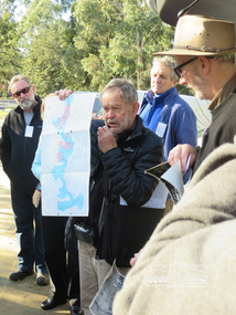
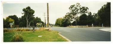
Newsletter No., 234, June 2017 Heritage Excursion - Saturday 1st July - Eltham Lower Park - Walk and Talk Eltham Lower Park has played an important part in the history of our area since the early days of European settlement when it was used by local residents as an informal racecourse. Prior to that its location at the junction of the Diamond Creek and the Yarra River made it an important meeting place for the Wurundjeri people. The park combines formal elements and sporting facilities with remnant bushland that is of environmental significance. It is home to sporting and horse riding clubs, popular play spaces and the Diamond Valley Miniature Railway, which attracts large numbers of visitors. The park will be the venue for our July excursion which will comprise a walk of about 3.5 km around the park and adjacent areas. Along the way we will discuss the history and natural history of the area. The path along the creek and the river provides a pleasant and scenic walk. This walk on Saturday 1st July is about 3.5 km in length and will take 2 to 2.5 hours. It will start at 2pm at the Main Road car park at the front of the park. (Melway ref 21 H 10). Born Digitalelection day, heritage excursion, activities, eltham district historical society, eltham lower park -
 Eltham District Historical Society Inc
Photograph, Liz Pidgeon, Heritage Excursion; Eltham Lower Park Walk and Talk, 1 July 2017, 1 July 2017
Newsletter No., 234, June 2017 Heritage Excursion - Saturday 1st July - Eltham Lower Park - Walk and Talk Eltham Lower Park has played an important part in the history of our area since the early days of European settlement when it was used by local residents as an informal racecourse. Prior to that its location at the junction of the Diamond Creek and the Yarra River made it an important meeting place for the Wurundjeri people. The park combines formal elements and sporting facilities with remnant bushland that is of environmental significance. It is home to sporting and horse riding clubs, popular play spaces and the Diamond Valley Miniature Railway, which attracts large numbers of visitors. The park will be the venue for our July excursion which will comprise a walk of about 3.5 km around the park and adjacent areas. Along the way we will discuss the history and natural history of the area. The path along the creek and the river provides a pleasant and scenic walk. This walk on Saturday 1st July is about 3.5 km in length and will take 2 to 2.5 hours. It will start at 2pm at the Main Road car park at the front of the park. (Melway ref 21 H 10). Born Digitalheritage excursion, activities, eltham district historical society, eltham lower park -
 Eltham District Historical Society Inc
Photograph, Liz Pidgeon, Heritage Excursion; Eltham Lower Park Walk and Talk, 1 July 2017, 1 July 2017
Newsletter No., 234, June 2017 Heritage Excursion - Saturday 1st July - Eltham Lower Park - Walk and Talk Eltham Lower Park has played an important part in the history of our area since the early days of European settlement when it was used by local residents as an informal racecourse. Prior to that its location at the junction of the Diamond Creek and the Yarra River made it an important meeting place for the Wurundjeri people. The park combines formal elements and sporting facilities with remnant bushland that is of environmental significance. It is home to sporting and horse riding clubs, popular play spaces and the Diamond Valley Miniature Railway, which attracts large numbers of visitors. The park will be the venue for our July excursion which will comprise a walk of about 3.5 km around the park and adjacent areas. Along the way we will discuss the history and natural history of the area. The path along the creek and the river provides a pleasant and scenic walk. This walk on Saturday 1st July is about 3.5 km in length and will take 2 to 2.5 hours. It will start at 2pm at the Main Road car park at the front of the park. (Melway ref 21 H 10). Born Digitalheritage excursion, activities, eltham district historical society, eltham lower park, sign, shared path -
 Greensborough Historical Society
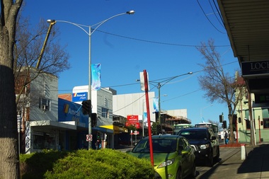
Photograph - Digital image, Marilyn Smith, New construction, Main Street Greensborough, 19/08/2015
New development at 78 Main Street Greensborough. Photo centres on the Amcal Chemist at 100 Main Street.Digital copy of colour photographmain street greensborough -
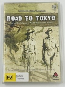 4th/19th Prince of Wales's Light Horse Regiment Unit History Room
Film - DVD, Road To Tokyo
DVD in CaseRoad To Tokyothe last brutal year of ww2 in the pacific -
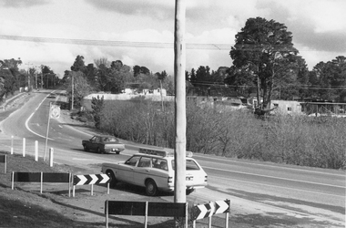
 Ringwood and District Historical Society
Photograph, Intersection of Warrandyte Road with Old Warrandyte Road and Tortice Dr. 1981
Written on back of photograph, "19/6/81. Looking south-west from intersection of Warrandyte Road with Old Warrandyte Road and Tortice Dr." -
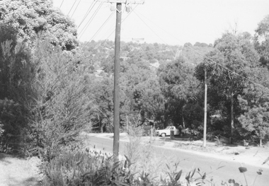
 Ringwood and District Historical Society
Photograph, Junction of Warrandyte Road, Old Warrandyte Road and Tortice Drive, North Ringwood looking south 1981
Written on back of photograph, "19/6/81. The junction of Warrandyte Road, Old Warrandyte Road and Tortice Drive, North Ringwood looking south." -
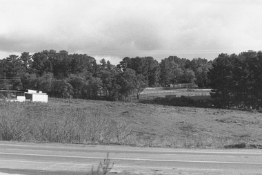
 Ringwood and District Historical Society
Photograph, Looking from Glenvale Road North Ringwood, across Glenvale towards Deep Creek Road 1982
Written on back of photograph, "21/4/82. Looking from Glenvale Road across Glenvale towards Deep Creek Road seen in distance." -
 Ringwood and District Historical Society
Postcard, View of Ringwood looking East from Warrandyte Road /Whitehorse Road intersection. Circa 1916
Sepia photograph on front of Postcard"Written on back of Postcard" View of Ringwood looking East from Warrandyte Road/Whitehorse Road intersection. Circa 1916. Presbyterian Church in foreground -
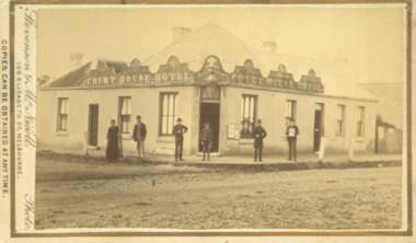 Bacchus Marsh & District Historical Society
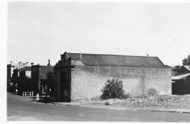
Photograph, Court House Hotel Main Street Bacchus Marsh 1883
This building on the corner of Court House Place and Main Street Bacchus Marsh was a licensed hotel since 1864. Prior to 1864 the building was in use as a saddlery business, established by Joseph Purday and Alfred Smith. In 1864, Purday and Alfred Tanner converted the shop to a hotel. Tanner, followed by his wife Ann, were licensees until 1892. The hotel signage above the door features the Prince of Wales feathers, an acknowledgement of the Prince of Wales Volunteer Light Horse Werribee unit which used the hotel for their meetings. In 1911 the single-storey hotel was demolished and a two-storey brick hotel was built. The identities of the five men and one woman in the photo are not known. The woman at the left of the group is possibly Ann Tanner who was the licensee around the time this photograph was taken. Small sepia unframed photograph on card with gold border framing photograph. Housed in the album, 'Photographs of Bacchus Marsh and District in 1883 by Stevenson and McNicoll'. A group of five men and one woman can be seen standing in front of the Court House Hotel building, Main Street Bacchus Marsh. A large ornate sign around the roofline bears the words “Courthouse Hotel”. Above the door a sign featuring the Prince of Wales feathers also has the name “Ann Tanner.” One of the men is displaying a document which apparently is of some importance, now lost.On the front: Stevenson & McNicoll. Photo. 108 Elizabeth St. Melbourne. COPIES CAN BE OBTAINED AT ANY TIME. On the back: LIGHT & TRUTH inscribed on a banner surmounted by a representation of the rising sun. Copies of this Portrait can be had at any time by sending the Name and Post Office Money Order or Stamps for the amount of order to STEVENSON & McNICOLL LATE BENSON & STEVENSON, Photographers. 108 Elizabeth Street, MELBOURNE. stevenson and mcnicoll 1883 photographs of bacchus marsh and district, hotels bacchus marsh, court house hotel bacchus marsh -
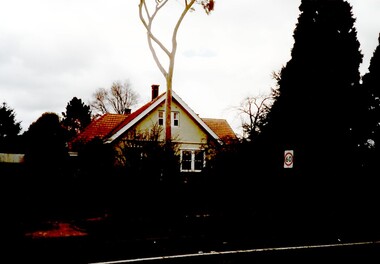 Surrey Hills Historical Society Collection
Photograph, 627 Whitehorse Road, Surrey Hills
This has been a home/surgery for a number of general practitioners. Dr Hedley Francis Summons is listed on the 1931 and 1936 electoral roll as resident / practising here. He was born in Kew in 1899 (died in 1967) and married Elsie Florence Finlayson in 1925. They had a son and daughter. In 1937 the family returned to Melbourne from Edinburgh. He became Lt Colonel of the 2nd 9th Field Ambulance, 2nd AIF in WW2. He was taken POW on the fall of Singapore and there is a portrait of him by Murray Griffin done in Changi. Dr Lorimer Grant Morton (1904-1989) graduated in 1931 and was registered at 627 Whitehorse Road in that year until c1937. Dr Alan Herbert McNaughton graduated in 1932 and was the general practitioner during the WW2. He is listed at the address in the 1942 and 1943 electoral roll. He married Nancy Winifred Bottomley in 1940. Dr Jack Ramsay Collie (1914-1990) was a general practitioner at 627 Whitehorse Road from c1954-1980. He served in RAN in WW2; married Mary Sewell Graham in 1945 and had a son and a daughter. 627 Whitehorse Road probably ceased as a medical practice after his retirement. Sale history: Sold in November 2007 by Marshall White Real Estate for $1.455M Sold in September 2011 by Jellis Craig real Estate for $1.75MThe house is significant as an example of past practice of general practitioners having their surgeries as part of their home. This example is from a later date than the Surrey Hills Medical Centre (SHMC) at 174 Union Road, which was purpose-built for Dr James Landells Blakie in c1911. In this case the building has reverted to domestic use, whereas in the case of SHMC its use became solely medical.A coloured photograph of a house with an established garden and a wire fence along the front. A tall gum tree stands in front of the house.surrey hills, whitehorse road, doctors, dr hedley francis summons, dr jack ramsay collie, (miss) mary sewell graham, (mrs) mary sewell collie, dr donald malcolm collie, (miss) elsie florence finlayson, (mrs) elsie florence summons, dr alan herbert mcnaughton, (mrs) nancy winifred mcnaughton, dr lorimer grant morton -
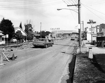 Greensborough Historical Society
Photograph - Digital Image, Main Street upgrade 1978c, 1978c
Photograph of upgrade works in lower Main Street area, taken c1978. Shows roadworks on Main Street Greensborough.Digital copy of black and white photographmain street greensborough -
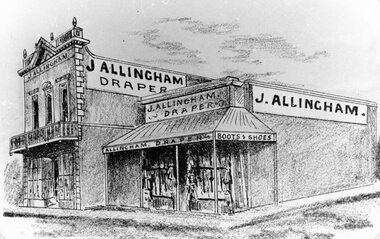 Stawell Historical Society Inc
Drawing, Mr J Allingham, Draper in Main Street Stawell from the P.C. News Supplement 1888 -- Sketch
J Allingham Draper Main Street from P.C. News Supplement 1888 Approx 149 Main Streetstawell businesses -
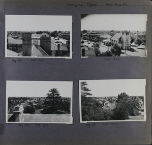 Glen Eira Historical Society
Album - Album page, Myoora, 405 Alma Road, Circa 1972
This photograph is part of the Caulfield Historical Album 1972. This album was created in approximately 1972 as part of a project by the Caulfield Historical Society to assist in identifying buildings worthy of preservation. The album is related to a Survey the Caulfield Historical Society developed in collaboration with the National Trust of Australia (Victoria) and Caulfield City Council to identify historic buildings within the City of Caulfield that warranted the protection of a National Trust Classification. Principal photographer thought to be Trevor Hart, member of Caulfield Historical Society. Most photographs were taken between 1966-1972 with a small number of photographs being older and from unknown sources. All photographs are black and white except where stated, with 386 photographs over 198 pages.Victorian Heritage Register (VHR) Number H0490 From the Victorian Heritage Register Database - Citation for Myoora https://vhd.heritagecouncil.vic.gov.au/places/275 (as at 6/10/2020) Myoora, 405 Alma Road, North Caulfield, was designed by Reed, Henderson & Smart and can be attributed to Anketell Henderson. It was built in 1886 and 1887 for Thomas Christian, who had founded the fabled gold mine, the Day Dawn at Charters Towers. He never occupied the house although his widow lived there for some time. The house was subdivided into three and later six flats. Myoora was one of many large mansions on broad acres with gardens in Caulfield. Perhaps the grandest was Labassa. The mansions date from the 1850s through to the late 1890s. The siting of Myoora on a ridge influenced its planning and composition. A central hall and corridor along the ridge is entered from the centre of the more formal north facade. The entrance is marked by an elaborately detailed tower. A stair turret provides a second accent. The western end of the building is completed by a massively detailed chimney as the service wing. The south facade enjoyed an outlook to port phillip from a two-storey cast iron verandah. Bay windows, chimneys, the tower and the turret and minor details are brought together in a sophisticated asymmetrical composition. This is reflected in the planning. The asymmetry of Myoora pivoting on the tower is the most notable feature of the building. The walls are built of cement rendered brick. The cement render has not been painted. The roof is slate. The balconies and verandah are cast iron. The footings and cellar are bluestone. The architectural firm Reed, Henderson & Smart was very prominent in Victoria in the nineteenth century. Anketell Henderson was an eminent and well respected member of the profession. He worked successfully in London and interstate as well as in Victoria. They were better known for commercial and public buildings. Myoora is an important private commission. The style of Myoora is a combination of details from the Continental and English Renaissance through the boom style and the Queen Anne style. There is also an early influence from the American Romanesque style especially in the stair turret. The latter style was important at the turn of the century and Myoora is a significant precursor. Other buildings of a similar scale survive in Caulfield and elsewhere. Labassa, the most fabulous, is quite different stylistically as are most of the other comparable mansions. Stonnington is perhaps closer but relies on different details from the Queen Anne style and lacks any American influence. For its historical associations through its owners and architects, for its style and composition and for its intactness, Myoora is significant at a State level. The craftmanship of Myoora is what could be expected of a building of the time and type. It is relatively intact and in fair condition. The main staircase has been removed, minor alterations to decorative features have occurred and additions have been made to the exterior.Page 18 of Photograph Album including four black and white photographs. All are arranged in landscape orientation with two on the top half of the page and the other two below.Handwritten: views from "Myoora" 405 Alma Road / [top right hand] / Neg 188 Dec 1972 [under top left photo] / Dec 1972 [under top right photo] / Neg 184 Dec 1972 [under bottom left photo] / Neg 168 Dec 1972 [under bottom right photo] / 18 [bottom right]caulfield north, trevor hart, alma road, mansion, myoora, tower, thomas christian, 1880's, queen anne, turret, cement rendered brick, unpainted, balconies, verandahs, anketell henderson, continental and english renaissance, american romanesque, cast iron balconies, panoramic views, streetscapes, cast iron work, reed henderson & smart, asymmetrical style, gardens, slate roofs -
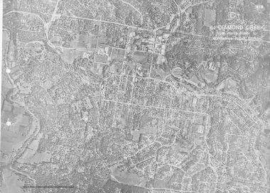 Eltham District Historical Society Inc
Work on paper (Sub-Item) - Aerial Photograph, Diamond Creek from Yarra River to Wattletree Road, Eltham
Black and white aerial photograph witrh key features around the central place of Eltham township marked inluding Yarra River, Main Road, Bridge Street and Ryans Road, Eltham North land development, real estate, aerial view, eltham, eltham north -
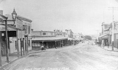 Stawell Historical Society Inc
Photograph, Lower Main Street Stawell looking West 1906 -- 2 Photos -- 1 Colour
Lower Main Street Stawell 1906 Bull and Mouth Hotel. Carters Boot Shop. Main Street looking Weststawell streetscape -
 Stawell Historical Society Inc
Photograph, Stawell Pleasant Creek News Newspaper Office in Main Street corner of Layzell Street 1938
Stawell News Newspaper Office 191 Main Street Stawell. NE Corner of Main Street and Layzell Street in 1938 -
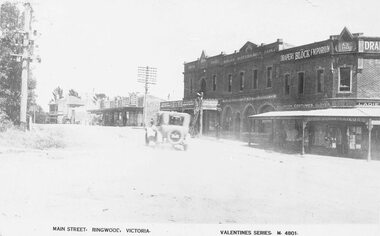 Ringwood and District Historical Society
Photograph, Maroondah Highway Central, Ringwood. Main Street looking west. Adelaide St. corner on right. c1924
Photograph (3 copies- 2 large black and white, 1 sepia postcard) Typed below one of the photographs, "Maroondah Highway looking west. Shops to right now Eastland carpark. Shops in centre are opposite station entrance" Typed below other copy: "Main St. looking west. Adelaide St corner on right. c1924." Typed on sepia postcard copy: "Main Street, Ringwood, Victoria. Valentines Series. M4801." -
 Tatura Irrigation & Wartime Camps Museum
Photograph, Goulburn Waranga No.2 Main Channel, 1957
Taken by the photographer for Victoria State Rivers and Water Supply Commission.Large sepia photograph dry mounted to cream board. Excavated channel with three levels - water in the lowest level, truck facing forward, second level, gang of workmen far distant on lowest level. Trees on horizon beyond top of bank.Below photo: "Goulburn-Waranga No.2 Channel"irrigation, channel, goulburn, waranga, victoria state rivers and water supply commission -
 Nillumbik Shire Council
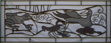
Deborah Halpern (b.1957 Melb) with Malcolm Laurence (b.1974 Melb), Malcolm Laurence, The Spirit of Nillumbik (balustrade panels x11); Location: Eltham Town Square - Main St, Eltham, 2001
In October 2000, Council invited three artists from the region (Deborah Halpern, Matcham Skipper, Tony Trembath) to submit designs for a sculpture / public art work for the Eltham Town Square. The commission was paid for by supermarket giant Safeway (Woolies) as part of its supermarket permit, which required them to contribute to beautification work in the Town Square.This is the first of three parts. The 'Spirit of Nillumbik' is a celebration of the artistic spirit of Eltham and surrounding communities. Each area is identified through the flora and fauna represented in the panels. The work honours the many creative artists and architects, past and present, who have built homes and shaped lives and livelihoods with their unique creative spirit. Halpern describes her work as a public expression of their individual and collective visions. Halpern acknowledges these contributions to our hand-made history and the influence they have on the character and identity of Eltham and Nillumbik. Five picture and six woven balustrades each made out of welded steel / organic wrought iron and coated with wax. Imagery (flora - plants, landscapes and fauna - animals, birds, reptiles, insects) are all based on the local environment. There is also a relevant aboriginal presence amongst each of the panels. Each panel represents the different areas that make up the Shire. 'Water' for Warrandyte, 'Kangaroos' for Christmas Hills, 'Cockatoos and 'Valley Creek Flats' for Hurstbridge, 'Wombats', 'Bluetongues' and 'Possums' for St. Andrews/Kinglake, 'Orchids' for Panton Hill, 'Cows' and 'Grapevines' for the Kangaroo Gound Hill landmark. N/Apublic art, nillumbik, fauna, flora, wrought iron, balustrade, halpern, laurence, kangaroo, eltham town square, spirit, warrandyte, christmas hills, kangaroo ground, hurstbridge, kinglake, panton hill, water, valley creek flats, cockatoos -
 Nillumbik Shire Council
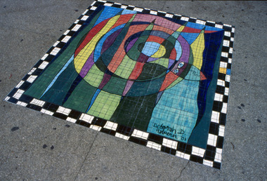
Floor mosaic: Deborah Halpern (b.1957 Melb.), Deborah Halpern, The Spirit of Nillumbik (Mosaic), Location: Eltham Town Square - Main St, Eltham, 2001
In October 2000, Council invited three artists from the region (Deborah Halpern, Matcham Skipper, Tony Trembath) to submit designs for a sculpture / public art work for the Eltham Town Square. The commission was paid for by supermarket giant Safeway (Woolies) as part of its supermarket permit, which required them to contribute to beautification work in the Town Square. This is the second of three parts. The 'Spirit of Nillumbik' is a celebration of the artistic spirit of Eltham and surrounding communities. Each area is identified through the flora and fauna represented in the panels. The work honours the many creative artists and architects, past and present, who have built homes and shaped lives and livelihoods with their unique creative spirit. Halpern describes her work as a public expression of their individual and collective visions. Halpern acknowledges these contributions to our hand-made history and the influence they have on the character and identity of Eltham and Nillumbik. Square floor mosaic. Black and white chequered border. Multicoloured coiled snake intercepted with six multicoloured peaks. Made up of small mosaic tiles and hand painted. Hand painted artist signature bottom right hand side. 'Deborah D. Halpern '01'eltham, halpern, mosaic, snake, square, laurence, painted, tiles, spirit, nillumbik -
 Tatura Irrigation & Wartime Camps Museum
Photograph, Whim Inn Corner, Hogan Street and Dhurringile Road, Tatura
Shows picture of Whim Inn corner, Hogan Street and Dhurringile Road, Tatura. Colour photograph showing the intersection of Hogan Street, and Dhurringile Road, Tatura. Known as Whim Inn corner. Before round about put in. Photograph stuck onto piece of white cardboard. hogan street tatura, dhurringile road tatura, whim inn tatura -
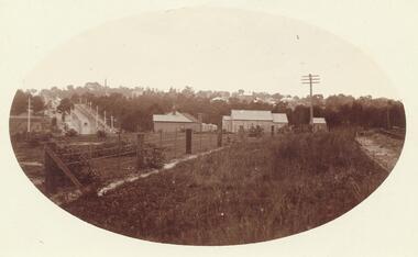
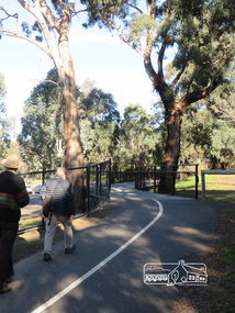 Eltham District Historical Society Inc
Photograph, Liz Pidgeon, Heritage Excursion; Eltham Lower Park Walk and Talk, 1 July 2017, 1 July 2017
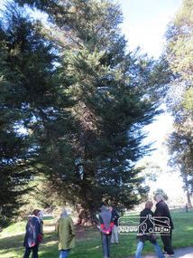
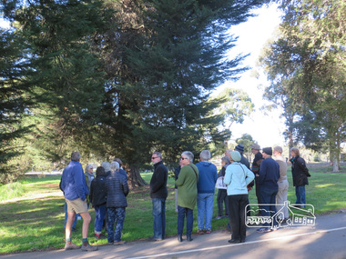
Walking along the shared pathway of the Diamond Creek Trail Newsletter No., 234, June 2017 Heritage Excursion - Saturday 1st July - Eltham Lower Park - Walk and Talk Eltham Lower Park has played an important part in the history of our area since the early days of European settlement when it was used by local residents as an informal racecourse. Prior to that its location at the junction of the Diamond Creek and the Yarra River made it an important meeting place for the Wurundjeri people. The park combines formal elements and sporting facilities with remnant bushland that is of environmental significance. It is home to sporting and horse riding clubs, popular play spaces and the Diamond Valley Miniature Railway, which attracts large numbers of visitors. The park will be the venue for our July excursion which will comprise a walk of about 3.5 km around the park and adjacent areas. Along the way we will discuss the history and natural history of the area. The path along the creek and the river provides a pleasant and scenic walk. This walk on Saturday 1st July is about 3.5 km in length and will take 2 to 2.5 hours. It will start at 2pm at the Main Road car park at the front of the park. (Melway ref 21 H 10). Born Digitalheritage excursion, activities, eltham district historical society, eltham lower park, walking, diamond creek trail, shared pathway -
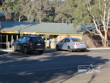 Eltham District Historical Society Inc
Photograph, Liz Pidgeon, Heritage Excursion; Eltham Lower Park Walk and Talk, 1 July 2017, 1 July 2017
Sports pavilion with signage for Eltham Lacrosse Club and Lower Eltham Cricket Club Newsletter No., 234, June 2017 Heritage Excursion - Saturday 1st July - Eltham Lower Park - Walk and Talk Eltham Lower Park has played an important part in the history of our area since the early days of European settlement when it was used by local residents as an informal racecourse. Prior to that its location at the junction of the Diamond Creek and the Yarra River made it an important meeting place for the Wurundjeri people. The park combines formal elements and sporting facilities with remnant bushland that is of environmental significance. It is home to sporting and horse riding clubs, popular play spaces and the Diamond Valley Miniature Railway, which attracts large numbers of visitors. The park will be the venue for our July excursion which will comprise a walk of about 3.5 km around the park and adjacent areas. Along the way we will discuss the history and natural history of the area. The path along the creek and the river provides a pleasant and scenic walk. This walk on Saturday 1st July is about 3.5 km in length and will take 2 to 2.5 hours. It will start at 2pm at the Main Road car park at the front of the park. (Melway ref 21 H 10). Born Digitalheritage excursion, activities, eltham district historical society, eltham lower park, pavilion, sports pavilion, eltham lacrosse club, lower eltham cricket club, car parking -
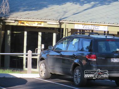 Eltham District Historical Society Inc
Photograph, Liz Pidgeon, Heritage Excursion; Eltham Lower Park Walk and Talk, 1 July 2017, 1 July 2017
Sports pavilion with signage for Eltham Lacrosse Club and Lower Eltham Cricket Club Newsletter No., 234, June 2017 Heritage Excursion - Saturday 1st July - Eltham Lower Park - Walk and Talk Eltham Lower Park has played an important part in the history of our area since the early days of European settlement when it was used by local residents as an informal racecourse. Prior to that its location at the junction of the Diamond Creek and the Yarra River made it an important meeting place for the Wurundjeri people. The park combines formal elements and sporting facilities with remnant bushland that is of environmental significance. It is home to sporting and horse riding clubs, popular play spaces and the Diamond Valley Miniature Railway, which attracts large numbers of visitors. The park will be the venue for our July excursion which will comprise a walk of about 3.5 km around the park and adjacent areas. Along the way we will discuss the history and natural history of the area. The path along the creek and the river provides a pleasant and scenic walk. This walk on Saturday 1st July is about 3.5 km in length and will take 2 to 2.5 hours. It will start at 2pm at the Main Road car park at the front of the park. (Melway ref 21 H 10). Born Digitalheritage excursion, activities, eltham district historical society, eltham lower park, pavilion, eltham lacrosse club, eltham cricket club -
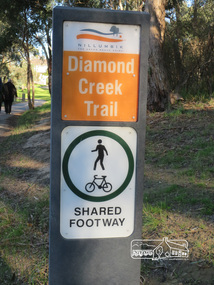 Eltham District Historical Society Inc
Photograph, Liz Pidgeon, Heritage Excursion; Eltham Lower Park Walk and Talk, 1 July 2017, 1 July 2017
Sign produced by Shire of Nillumbik: Diamond Creek Trail shared footway Newsletter No., 234, June 2017 Heritage Excursion - Saturday 1st July - Eltham Lower Park - Walk and Talk Eltham Lower Park has played an important part in the history of our area since the early days of European settlement when it was used by local residents as an informal racecourse. Prior to that its location at the junction of the Diamond Creek and the Yarra River made it an important meeting place for the Wurundjeri people. The park combines formal elements and sporting facilities with remnant bushland that is of environmental significance. It is home to sporting and horse riding clubs, popular play spaces and the Diamond Valley Miniature Railway, which attracts large numbers of visitors. The park will be the venue for our July excursion which will comprise a walk of about 3.5 km around the park and adjacent areas. Along the way we will discuss the history and natural history of the area. The path along the creek and the river provides a pleasant and scenic walk. This walk on Saturday 1st July is about 3.5 km in length and will take 2 to 2.5 hours. It will start at 2pm at the Main Road car park at the front of the park. (Melway ref 21 H 10). Born Digitalelection day, heritage excursion, activities, eltham district historical society, eltham lower park, sign -
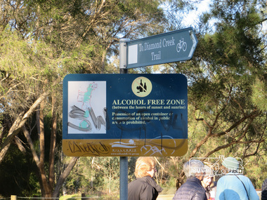 Eltham District Historical Society Inc
Photograph, Liz Pidgeon, Heritage Excursion; Eltham Lower Park Walk and Talk, 1 July 2017, 1 July 2017
Signage - To Diamond Creek Trail and Alcohol free zone Newsletter No., 234, June 2017 Heritage Excursion - Saturday 1st July - Eltham Lower Park - Walk and Talk Eltham Lower Park has played an important part in the history of our area since the early days of European settlement when it was used by local residents as an informal racecourse. Prior to that its location at the junction of the Diamond Creek and the Yarra River made it an important meeting place for the Wurundjeri people. The park combines formal elements and sporting facilities with remnant bushland that is of environmental significance. It is home to sporting and horse riding clubs, popular play spaces and the Diamond Valley Miniature Railway, which attracts large numbers of visitors. The park will be the venue for our July excursion which will comprise a walk of about 3.5 km around the park and adjacent areas. Along the way we will discuss the history and natural history of the area. The path along the creek and the river provides a pleasant and scenic walk. This walk on Saturday 1st July is about 3.5 km in length and will take 2 to 2.5 hours. It will start at 2pm at the Main Road car park at the front of the park. (Melway ref 21 H 10). Born Digitalelection day, heritage excursion, activities, eltham district historical society, eltham lower park, sign, alcohol free zone -
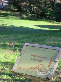 Eltham District Historical Society Inc
Photograph, Liz Pidgeon, Heritage Excursion; Eltham Lower Park Walk and Talk, 1 July 2017, 1 July 2017
Information Board - Lenister Farm Wetlands Newsletter No., 234, June 2017 Heritage Excursion - Saturday 1st July - Eltham Lower Park - Walk and Talk Eltham Lower Park has played an important part in the history of our area since the early days of European settlement when it was used by local residents as an informal racecourse. Prior to that its location at the junction of the Diamond Creek and the Yarra River made it an important meeting place for the Wurundjeri people. The park combines formal elements and sporting facilities with remnant bushland that is of environmental significance. It is home to sporting and horse riding clubs, popular play spaces and the Diamond Valley Miniature Railway, which attracts large numbers of visitors. The park will be the venue for our July excursion which will comprise a walk of about 3.5 km around the park and adjacent areas. Along the way we will discuss the history and natural history of the area. The path along the creek and the river provides a pleasant and scenic walk. This walk on Saturday 1st July is about 3.5 km in length and will take 2 to 2.5 hours. It will start at 2pm at the Main Road car park at the front of the park. (Melway ref 21 H 10). Born Digitalheritage excursion, activities, eltham district historical society, eltham lower park, information board, lenister farm -
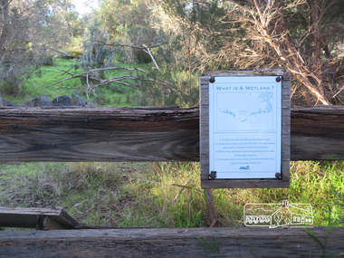 Eltham District Historical Society Inc
Photograph, Liz Pidgeon, Heritage Excursion; Eltham Lower Park Walk and Talk, 1 July 2017, 1 July 2017
Sign on trail - what is a wetland Newsletter No., 234, June 2017 Heritage Excursion - Saturday 1st July - Eltham Lower Park - Walk and Talk Eltham Lower Park has played an important part in the history of our area since the early days of European settlement when it was used by local residents as an informal racecourse. Prior to that its location at the junction of the Diamond Creek and the Yarra River made it an important meeting place for the Wurundjeri people. The park combines formal elements and sporting facilities with remnant bushland that is of environmental significance. It is home to sporting and horse riding clubs, popular play spaces and the Diamond Valley Miniature Railway, which attracts large numbers of visitors. The park will be the venue for our July excursion which will comprise a walk of about 3.5 km around the park and adjacent areas. Along the way we will discuss the history and natural history of the area. The path along the creek and the river provides a pleasant and scenic walk. This walk on Saturday 1st July is about 3.5 km in length and will take 2 to 2.5 hours. It will start at 2pm at the Main Road car park at the front of the park. (Melway ref 21 H 10). Born Digitalheritage excursion, activities, eltham district historical society, eltham lower park, sign