Showing 3609 items
matching street map
-
 Tramways/East Melbourne RSL Sub Branch - RSL Victoria Listing id: 27511
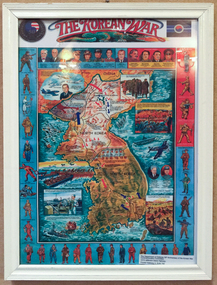
Poster - Print, The Korean War
'The Department of Defence 50th Anniversary of the Korean War Commemoration Committee. 1213 Jefferson Davis Highway Crystal Gateway 4, Suite 702'Framed print of an illustrated image detailing the Korean War. Image details a map of Korea, all political personal involved, and each nation involved wearing their uniform. Small insert under frame states: 'The Department of Defence 50th Anniversary of the Korean War Commemoration Committee. 1213 Jefferson Davis Highway Crystal Gateway 4, Suite 702'korean war, 50th anniversary of korean war, korea map, illustration -
 Southern Sherbrooke Historical Society Inc.
Map - photocopy
A photocopy taken from the original land sale map provided to the society through Karel Coxell of Stockdale & Leggo. The original maps are stored in large bound account books and were originally the propert of McNally Real Estate. The books are held (in 2A3 photocopy of plan of survey of part of Crown Allotments 20 & 21, section C, parish of Narre Worran, County of Mornington. Clements Ave and environs in Belgrave Heights"Villette Estate" in top LH corner, "Locality Plan" in bottom LH corner, "Not in sale" written on one block and crossed out. All handwritten in pencil on original. "Colby Drive " and "Verona Street" added in pencil to copy.land sales, advertisements, subdivision -
 South Gippsland Shire Council
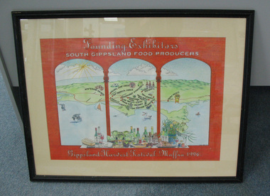
Poster, Framed, Founding Exhibitors, 1996
Framed colour poster titled: "Founding Exhibitors" produced by the South Gippsland Food Producers for the Gippsland Harvest Festival in 1996. Features drawing of orange arched windows with map of Wilsons Promotory in distance. On the map a number of local businesses are highlighted. Variety of foods and wines feature in the front of the arches. Cream card window mount. Dark brown wood frame. -
 South Gippsland Shire Council
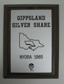
Plaque, Gippsland Silver Share
Wood plaque with silver engraved plate affixed to front. Features a map of Victoria in the centre and logoat bootom edge. Dark polished timber. -
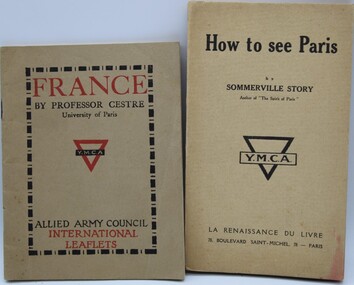
 Ringwood RSL Sub-Branch
Booklet, Paris map
... Ringwood RSL Sub-Branch 16 Station Street Ringwood ...Map of Paris and info booklet for Englishmen and Americans and toilet guide -
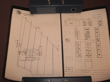 Wangaratta High School
WHS Map Drawings, 1984
Two black and white rolled-up scaled drawings of the existing school buildings with labelled classrooms, each mounted on black card. This item is was a part of a time capsule buried in Wangaratta High School grounds in 1984 -
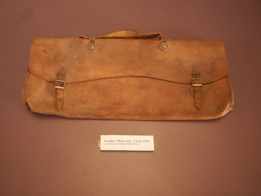 Wangaratta High School
WHS Leather Map Case, Circa 1916
Orange-brown leather map case with metal buckles. -
 Ringwood RSL Sub-Branch
Documents WW1, C WW1
... Ringwood RSL Sub-Branch 16 Station Street Ringwood ...1040.1 Map of London for sailors and soldiers (produced by the YMCA).1040.2 London Omnibus map 1040.3 YMCA Guide to France 1040.4 How to see Paries (as recommended by the YMCA) 1040.5 Penny Guide of Stratford-On-Avon 1040.6 The tramway Guide to Glasgow 1040.7 Silk ribbon Overseas Christmas Greeting 1918. -
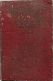 Ringwood RSL Sub-Branch
Book, Manual of Map Reading, 1955
Hard cover book with fold out maps with 132 printed pages text. Author - The War Office 1955Airphoto reading, Field sketching. -
 Ringwood RSL Sub-Branch
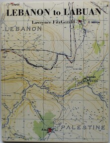
Book - WW2, Lebanon to Labuan, June 1980
Hard cover with dust cover. 124 pages with black and white photos. The story of the Australian Army map makers. -
 Ringwood RSL Sub-Branch
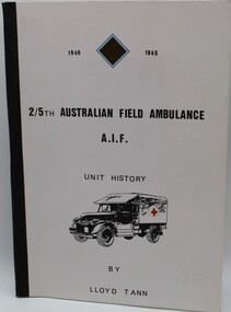
Book - WW2, 2/5th Australian Field Ambulance, 1987
Soft cover with black and white prints and maps. 125 pages. A history of the 2/5 Australian Field Ambulance in WW2. -
 Ringwood RSL Sub-Branch
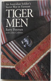
Book - Vietnam, Tiger Men, 1988
An Australian Soldier's Secret War in Vietnam. Soft cover, no dust cover. 245 pages with black and white prints and maps -
 Ringwood RSL Sub-Branch
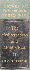
Book - WW2, Mediteranean and Middle East volume 2, 1954
Volume 2 392 pages Maps and black and white prints -
 Ringwood RSL Sub-Branch
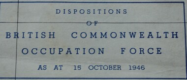
Document, July 1946
... Ringwood RSL Sub-Branch 16 Station Street Ringwood ...Map of Southern Japan showing dispositions of British Commonwealth Occupation Forces as at 15 October 1946 -
 Royal District Nursing Service (now known as Bolton Clarke)
Photograph - Photograph, black and white, Barry Sutton, 01.05.1974
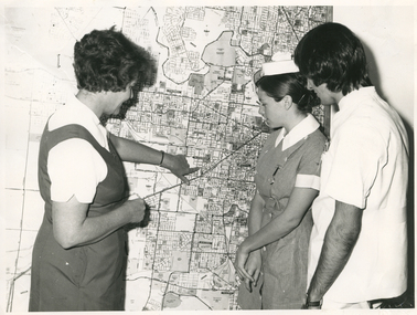
Sister Ellen Anderson is the Supervisor of the Royal District Nursing Service, (RDNS) Footscray Centre. She is wearing her RDNS uniform of a short sleeve white blouse under a royal blue V neck tunic style dress. Sr. Anderson is showing two Student nurses from Western General Hospital the map with the areas covered by Footscray Centre. The map had different colour pins to identify streets where patients lived who were currently receiving nursing care from RDNS Sisters working in these areas (districts).During their training, Student nurses from several hospitals either attended the Royal District Nursing Service (RDNS), Education Department, or, a RDNS Nurse Educator travelled to the appropriate hospital’s Education Department to educate the Trainees on District nursing through the RDNS Community Nursing Program. Following the lectures Students went to a RDNS Centre and each Student accompanied a Trained nurse (Sister) for a week observing and gaining knowledge of all facets of nursing care in the home. This gave them an insight into the home conditions and situations patients faced after discharge from hospital. During 1971 there were 584 Student nurses who received field experience with RDNS. From its inception as Melbourne District Nursing Society (MDNS), in 1885, their Trained nurses (Nurses) worked in specific areas, 'districts'. The first Nurse worked east and west, between Victoria Parade and Flinders Street and, north and south, between Spencer Street and Spring Street. When a second Nurse was employed they divided this area at Elizabeth Street so each Nurse could attend to patients in the same area giving continuity of care. As the Society expanded, becoming Melbourne District Nursing Service, then, with Royal patronage, Royal District Nursing Service (RDNS) many Centres were opened throughout the Melbourne Metropolitan area and outer suburbs. The District nurse's areas (districts) grew and were divided within Shire boundaries for e.g. Knox 1, Knox 2, Knox 3, Knox 4, within the area of the Shire of Knox. A map covering the Centre’s Districts was attached to a wall, and its different colour pins identified streets where patients lived who were currently receiving nursing care from the RDNS Trained nurses (Sisters) working in these areas (districts).On the left of this black and white photograph is Royal District Nursing Service (RDNS), Sister Ellen Anderson, who has short dark curly hair and is wearing her RDNS uniform of a short sleeve white blouse under a dark V neck tunic style frock. She is standing side-on, towards the right of the photograph, and with her left hand is pointing to an area on a large map attached to the wall in the background. To her right, is a Student nurse who is facing Sr. Anderson, and looking at the area on the map. Under her white nurses cap, she has her long dark hair drawn back, and is wearing her hospital uniform of a short sleeve checked dress with white collar and cuffs; a nursing watch is attached to its upper left; her hands are clasped in front of her. To her right, is a male Student nurse who has collar length straight dark hair, and is wearing white trousers and a short sleeve white top with pens in the left upper pocket. He is looking at the areas on the map.. Barry Sutton MA 77 informationroyal district nursing service, rdns, rdns education, rdns centre, rdns district map, sister ellen anderson -
 Royal District Nursing Service (now known as Bolton Clarke)
Photograph - Photograph, black and white, Barry Sutton, 01.05.1974
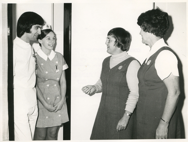
The photograph is taken at Western General Hospital. Royal District Nursing Service (RDNS) Nurse Educator, Sister Nan Deakin, after teaching the RDNS Community Nursing Education program to the Western General's two Student nurses is introducing them to Sister Ellen Anderson, Supervisor of the RDNS Footscray Centre. Sr. Anderson will arrange for the Students to go on District nursing visits with RDNS Trained nurses (Sisters) from Footscray Centre who administer nursing care in the community. Sister Deakin is wearing the RDNS winter uniform of a blue/grey skivvie under a blue/grey V neck tunic style frock made of herringbone winter material. Sister Anderson is wearing the RDNS summer uniform of a white short sleeve blouse under a royal blue V neck tunic style frock. The RDNS logo is seen on the upper left on both uniforms.During their training, Student nurses from several hospitals either attended the Royal District Nursing Service (RDNS), Education Department, or, a RDNS Nurse Educator travelled to the appropriate hospital’s Education Department to educate the Trainees on District nursing through the RDNS Community Nursing Program. Following the lectures Students went to an RDNS Centre and each Student accompanied a Trained nurse (Sister) for a week observing and gaining knowledge of all facets of nursing care in the home. This gave them an insight into the home conditions and situations patients faced after discharge from hospital. During 1971 there were 584 student nurses who received field experience with RDNS. From its inception as Melbourne District Nursing Society (MDNS), in 1885, their Trained nurses (Nurses) worked in specific areas, 'districts'. The first Nurse worked east and west, between Victoria Parade and Flinders Street and, north and south, between Spencer Street and Spring Street. When a second Nurse was employed they divided this area at Elizabeth Street so each Nurse could attend to patients in the same area giving continuity of care. As the Society expanded, becoming Melbourne District Nursing Service, then, with Royal patronage, Royal District Nursing Service (RDNS) many Centres were opened throughout the Melbourne Metropolitan area and outer suburbs. The District nurse's areas (districts) grew and were divided within Shire boundaries for e.g. Knox 1, Knox 2, Knox 3, Knox 4, within the area of the Shire of Knox. A map covering the Centre’s Districts was attached to a wall, and its different colour pins identified streets where patients lived who were currently receiving nursing care from the RDNS Trained nurses (Sisters) working in these areas (districts).On the far left of this black and white photograph is a male Student nurse, who has collar length, straight dark hair. He is wearing his hospital uniform of white trousers and top. To his right, is a Student nurse who is wearing her white nursing cap, with motif in the centre front, over her long drawn back dark hair. and her short sleeve uniform checked frock, with white two breasted buttons down it, and with white collar and cuffs. A nursing watch is attached to its upper left. Both are standing in the dark framed doorway of a room and are looking to the right and smiling at Royal District Nursing Service (RDNS), Nurse Educator, Sister Nan Deakin. She has short dark hair; is wearing glasses, and is wearing her RDNS uniform of a light grey skivvie under a darker V neck tunic style frock. To the right of her, is RDNS Sister Ellen Anderson who has short curly dark hair and is wearing her RDNS uniform of a white short sleeve blouse, under a dark V neck tunic style frock. They are standing side-on facing the Students. Barry Sutton MA 78royal district nursing service, rdns, rdns education, western general hospital students, sister nan deakin, sister ellen anderson -
Moorabbin Air Museum
Map (Item) - BOAC Britannia Fleet London to Colombo Route Map BA774
-
Moorabbin Air Museum
Work on paper (Item) - CAC Map, CAC Map- untitiled
Commonwealth Aircraft Corporation -
Moorabbin Air Museum
Map (Item) - RACV Royal Automobile Club Melbourne Victoria and Suburbs map
... Moorabbin Air Museum Moorabbin Airport 12 First Street ... -
Moorabbin Air Museum
Map (Item) - Ansett Route Map - Broken Hill <> Alice Springs
-
Moorabbin Air Museum
Equipment (Item) - J B Ryan Collection Navigator's Equipment and Survival Kit see Description for details
-
Moorabbin Air Museum
Document (Item) - Ansett Map of Operations in Northern Queensland, Cairns Aerial Service
Contains two copies of an undated map of Ansett routes in Northern Queensland. -
Moorabbin Air Museum
Souvenir (Item) - Ansett - Souvenir of Ansett & TAA inflight menus and old tickets AND Qantas route maps & menus
-
Moorabbin Air Museum
Map (Item) - Map of Port Melbourne & Coode Island Rifle Range circa 1950s-60s
... Moorabbin Air Museum Moorabbin Airport 12 First Street ... -
Moorabbin Air Museum
Booklet - Information and Route Maps System of the Golden Jets, Ansett
-
Moorabbin Air Museum
Booklet (Item) - Ansett Engineering Advertisement Booklet with Map of Ansett Facilities, Ansett Engineering Resources
Booklet features colour photographs advertising the various facilities Ansett can offer to potential customers -
Moorabbin Air Museum
Souvenir (Item) - Ansett - flight souvenirs, maps, company manners, staff booklets, Boeing 727 Fan Jet, Marketing Booklets
-
Moorabbin Air Museum
Document (Item) - 1970 Melbourne University Thesis on Australian Civil Aviation includes many newspaper articles and Kyeema crash map, Civil Aviation by G Shearer
-
Moorabbin Air Museum
Map (Item) - Associated Area Terminal Charts - Various
-
 Ballarat Tramway Museum
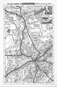
Map, Broadbent's, "Broadbent's Map 193 Bendigo", 1950s
... Map of Bendigo showing streets, with the tram routes... Parade Ballarat Ballarat goldfields Map of Bendigo showing ...Map of Bendigo showing streets, with the tram routes in dotted lines. Has a legend, scale and continuation maps. Gives an address of 475 Collins St Melbourne and a Melbourne telephone number - MR 2021.Yields information about Bendigo and its tram lines. Broadbents was a prolific publisher of maps. Map - single sided card, pocket map priced at 1/- - undated.bendigo, tramways, tram lines, maps, broadbents