Showing 32303 items
matching c
-
 Eltham District Historical Society Inc
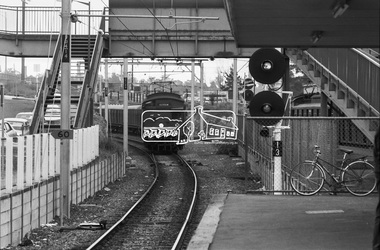
Photograph, George Coop, A Tait (Red Rattler) train departs Greensborough Railway Station bound for Princes Bridge, c. October 1982, 1982
Digital TIFF file Scan of 35mm Ilford FP4 black and white transparencygreensborough railway station, hurstbridge line, red rattler, tait train -
 Eltham District Historical Society Inc
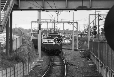
Photograph, George Coop, A Tait (Red Rattler) train arrives at Greensborough Railway Station bound for Eltham, c. October 1982, 1982
Digital TIFF file Scan of 35mm Ilford FP4 black and white transparencygreensborough railway station, hurstbridge line, red rattler, tait train -
 Eltham District Historical Society Inc
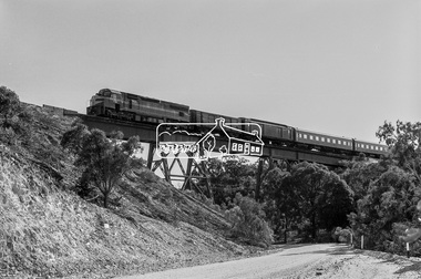
Photograph, George Coop, C-class Diesel Locomotive, C506, possibly at Ballan, en route to Ballarat, 18 October 1982, 1982
Digital TIFF file Scan of 35mm Ilford FP4 black and white transparencyballan, ballarat, c506, c-class diesel locomotive -
 Eltham District Historical Society Inc
Photograph, Birch Cottage, Eltham-Yarra Glen Road, c.1970, 1970
GC advised that when they first arrived in Eltham in the late 1960s, he would enjoy driving out to Yarra Glen. The Eltham-Yarra Glen road was unmade at the time. He passed this residence on the north side of the road. It was totally remote. GC found the juxtaposition of this little cottage with its surburban wire gate out in the remoteness of the landscape intriguing. Since then the road has been reconstructed and diverted away from the cottage which is now owned by Parks Victoria.Digital TIFF file Scan of 35mm Ilford HP4 black and white transparencyIlford HP4birch cottage, christmas hills, early settlers, edwin samuel birch, eltham-yarra glen road, honor mary birch, honor mary williams, john hill, watsons creek -
 Eltham District Historical Society Inc
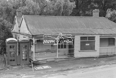
Photograph, Warrandyte Post Office, c.1972, 1972
The weatherboard building was built in the 1870s. It operated as a post office from 1876-1972. In 1988, the Warrandyte Historical Society took over the building and created a museum - https://whsoc.org.au/who-we-are/Of regional significance as an early building demonstrating the typical characteristics of early timber structures, and for its historical importance as the only relatively intact building in the town's main street dating from the gold mining period. It is also of local social significance for its important and continuing associations with the social and economic life of the town for over 100 years. - Victorian Heritage DatabaseDigital TIFF file Scan of 9 x 12.5 cm black and white printwarrandyte post office, telephone box, weatherboard house -
 Eltham District Historical Society Inc
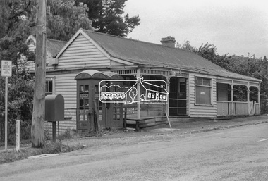
Photograph, Warrandyte Post Office, c.1972, 1972
The weatherboard building was built in the 1870s. It operated as a post office from 1876-1972. In 1988, the Warrandyte Historical Society took over the building and created a museum - https://whsoc.org.au/who-we-are/Of regional significance as an early building demonstrating the typical characteristics of early timber structures, and for its historical importance as the only relatively intact building in the town's main street dating from the gold mining period. It is also of local social significance for its important and continuing associations with the social and economic life of the town for over 100 years.- Victorian Heritage DatabaseDigital TIFF file Scan of 9 x 12.5 cm black and white printwarrandyte post office, telephone box, post office -
 Eltham District Historical Society Inc
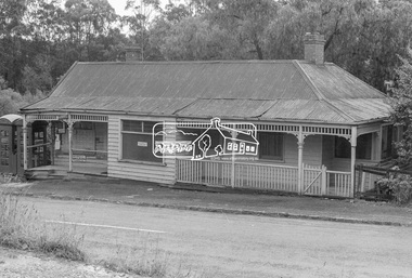
Photograph, Warrandyte Post Office, c.1972, 1972
The weatherboard building was built in the 1870s. It operated as a post office from 1876-1972. In 1988, the Warrandyte Historical Society took over the building and created a museum - https://whsoc.org.au/who-we-are/Of regional significance as an early building demonstrating the typical characteristics of early timber structures, and for its historical importance as the only relatively intact building in the town's main street dating from the gold mining period. It is also of local social significance for its important and continuing associations with the social and economic life of the town for over 100 years.- Victorian Heritage DatabaseDigital TIFF file Scan of 9 x 12.5 cm black and white printwarrandyte post office -
 Eltham District Historical Society Inc
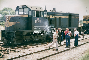
Photograph, Wheat train derailment near the yards of Dunolly Railway Station, Dunolly, Victoria, c.1975, 1975
GC visited Dunolly with his late father-in-law who used to be a gold miner up there. They were going past the station and noticed a wheat train had derailed in the yards and so he took the opportunity to photograph the goings-on. The fellow in the light grey slacks and beige shirt with tie approached GC and asked him what he was doing. He proposed that GC leave or alternatively, take as many photographs as he desired and then send him a complete set of prints, which GC did.Digital TIFF file Scan of 12.6 x 18.6 cm colour printb class diesel-electric locomotive, b80, derailment, dunolly, dunolly railway station, t-364, t-383, t-class diesel electric locomotive, victorian railways, wheat train -
 Eltham District Historical Society Inc
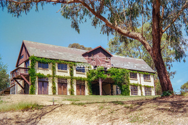
Negative - Photograph, "The Barn", built by Jelbart, c.1945, 93 Arthur Street, Eltham, 1998c
Statement of Significance Last updated on - January 5, 2010 REVISED STATEMENT OF SIGNIFICANCE, CONTEXT, 2010 What is significant? The c1950s Jelbart residence and the c1945 barn, the garden and the gate posts and the surrounding site to the extent of the title boundaries. How is it significant? The Jelbart house and barn are historically and architecturally significant to the Shire of Nillumbik. The garden and the gate posts are historically and aesthetically significant to the Shire of Nillumbik. Why is it significant? The Jelbart house and barn are historically significant because they are unusually large and because together they comprise one of the oldest groups of substantial mud brick buildings erected during the 20th century in the Shire of Eltham and foreshadow the large mud brick residences of the 1960s and 1970s for which the area is well known (Criteria A & B). The buildings are architecturally significant because their construction (using timber post framing and mud brick walling) is a characteristic feature of what became known as the 'Eltham style'- which was prevalent in the area during the mid and latter parts of the 20th century (Criteria D & A). The garden and the gate posts - The garden is historically significant because it is a remainder of a large holding of 200 acres associated with the house (Criterion A).The gate posts are historically and aesthetically significant because they were taken from a 19th-century Toorak mansion and because their removal and re-use illustrates the practice of recycling material from demolished buildings that was one of the characteristic features of 'Eltham-style' architecture (Criteria A, D & E).Roll of 35mm colour negative film, 8 strips and associated 10 x 15 cm colour printKodak Gold 100-5arthur street, eltham, jelbart barn -
 Eltham District Historical Society Inc
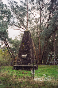
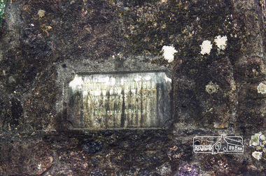
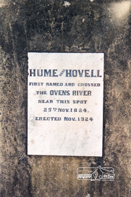
Photograph, Hume and Hovell Monument, Back Creek Road, old Back Creek school site, Back Creek, c.1998, 1998c
Stage 3 tour of Hume and Hovell monuments organised by Russell Yeoman. At the centenary of Hume and Hovell exploration in 1924 a committee was formed to co-ordinate and organise local celebrations along the route from Albury to Corio Bay. An itinerary was created for the unveiling ceremonies giving the hour and date for each place concerned from 15 to 21 November 1924. Thirty-three monuments or cairns were erected at Violet Town, Euroa, Avenel, Seymour, Broadford, Kilmore, Mount Bland, Bulla, Moyhu, Hansonville, Benalla, Samaria, Swanpool, Yarck, Yea, The Horn (Buffalo), Myrtleford, Whorouly, Everton, Murmungee, Stanley, Back Creek, Allan's Flat, Staghorn Flat, Ebden, Bethanga, Hume Reservoir, Strath Creek, Deer Park, Werribee, Lara, Bulla, Everton.Roll of 35mm colour negative film, 7 stripsKodak Gold 200-6activities, back creek, hume and hovell, monument -
 Eltham District Historical Society Inc
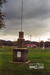
Photograph, Hume and Hovell Monument, Memorial Park Sports Ground, Whorouly, c.1998, 1998c
Stage 3 tour of Hume and Hovell monuments organised by Russell Yeoman. At the centenary of Hume and Hovell exploration in 1924 a committee was formed to co-ordinate and organise local celebrations along the route from Albury to Corio Bay. An itinerary was created for the unveiling ceremonies giving the hour and date for each place concerned from 15 to 21 November 1924. Thirty-three monuments or cairns were erected at Violet Town, Euroa, Avenel, Seymour, Broadford, Kilmore, Mount Bland, Bulla, Moyhu, Hansonville, Benalla, Samaria, Swanpool, Yarck, Yea, The Horn (Buffalo), Myrtleford, Whorouly, Everton, Murmungee, Stanley, Back Creek, Allan's Flat, Staghorn Flat, Ebden, Bethanga, Hume Reservoir, Strath Creek, Deer Park, Werribee, Lara, Bulla, Everton.Roll of 35mm colour negative film, 7 stripsKodak Gold 200-6activities, back creek, hume and hovell, monument -
 Eltham District Historical Society Inc
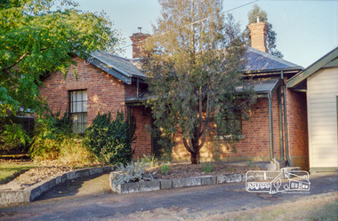
Photograph, Former Police Residence, 728 Main Road, Eltham, c. April 1998, 1998
Just prior to be becoming the Local History Centre and home to Eltham District Historical Society.Roll of 35mm colour negative film, 2 stripsKodak Gold 200-6eltham district historical society, main road, local history centre -
 Eltham District Historical Society Inc
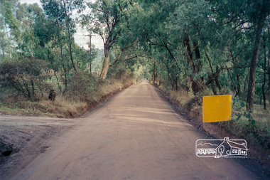
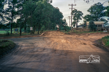
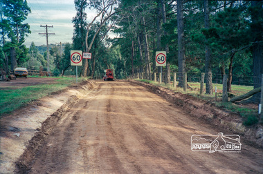
Photograph, Roadworks prior to sealing along Mount Pleasant Road near the junction with Reynolds Road, Eltham, c.1988, 1988c
Roll of 35mm colour negative film, 7 stripsFuji 1001988, eltham shire council, infrastructure, mount pleasant road, reynolds road, road construction -
 Eltham District Historical Society Inc
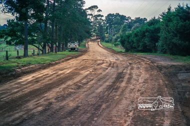
Photograph, Roadworks prior to sealing along Mount Pleasant Road near the junction with Reynolds Road, Eltham, c.1988, 1988c
Lou Siluzio's Blueberry farm, Lot 1, Mount Pleasant Road at corner of Reynolds RoadRoll of 35mm colour negative film, 7 stripsFuji 1001988, eltham shire council, infrastructure, mount pleasant road, reynolds road, road construction, blueberry farm, lou siluzio -
 Eltham District Historical Society Inc
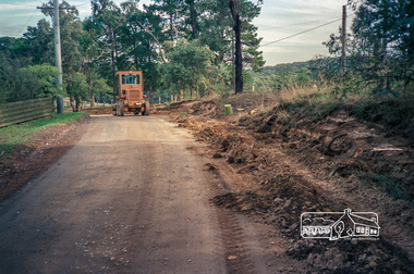
Photograph, Roadworks prior to sealing along Mount Pleasant Road near the junction with Reynolds Road, Eltham, c.1988, 1988c
Roll of 35mm colour negative film, 7 stripsFuji 1001988, eltham shire council, infrastructure, mount pleasant road, reynolds road, road construction -
 Eltham District Historical Society Inc
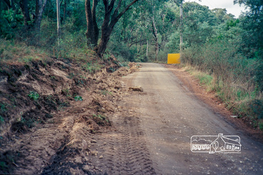
Photograph, Roadworks prior to sealing along Mount Pleasant Road near the junction with Reynolds Road, Eltham, c.1988, 1988c
Roll of 35mm colour negative film, 7 stripsFuji 1001988, eltham shire council, infrastructure, mount pleasant road, reynolds road, road construction -
 Eltham District Historical Society Inc
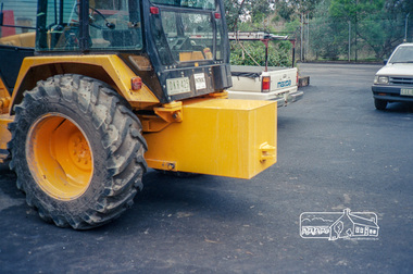
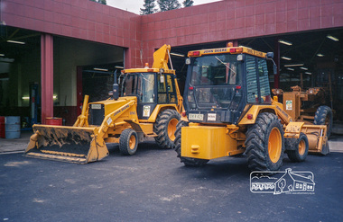
Photograph, Shire of Eltham earthmoving equipment at the Council Depot, Brisbane Street, Eltham, c.1988, 1988c
Site is now Eltham Fort Knox.Roll of 35mm colour negative film, 7 stripsFuji 100eltham shire council, infrastructure, depot, eltham fort knox, equipment -
 Eltham District Historical Society Inc
Photograph, Shire of Eltham earthmoving equipment at the Council Depot, Brisbane Street, Eltham, c.1988, 1988c
Site is now Eltham Fort Knox. These registration plates were issued in 1988.Roll of 35mm colour negative film, 7 stripsFuji 100eltham shire council, infrastructure, depot, eltham fort knox, equipment -
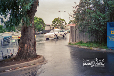
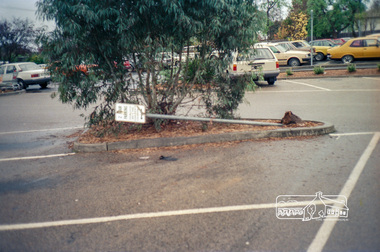
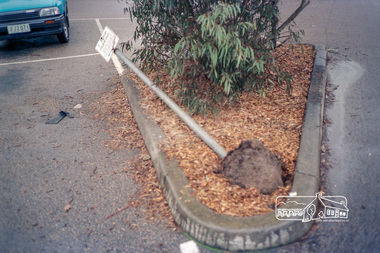
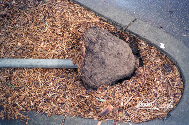
 Eltham District Historical Society Inc
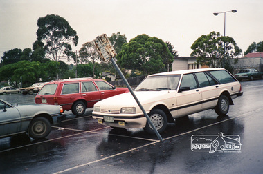
Photograph, Luck Street carpark, Eltham, c.1988, 1988c
Carpark located on the southern side of Luck Street behind what was then Franklins, now Dan Murphy's. Registration DFC issued 1987.Roll of 35mm colour negative film, 7 stripsFuji 100eltham shire council, infrastructure, carparks, dan murphy's, franklins supermarket, luck street -
 Eltham District Historical Society Inc
Photograph, Luck Street carpark, Eltham, c.1988, 1988c
Carpark located on the southern side of Luck Street behind what was then Franklins, now Dan Murphy's.Roll of 35mm colour negative film, 7 stripsFuji 100eltham shire council, infrastructure, carparks, dan murphy's, franklins supermarket, luck street -
 Eltham District Historical Society Inc
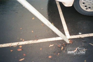
Photograph, Luck Street carpark, Eltham, c.1988, 1988c
Carpark located on the southern side of Luck Street behind what was then Franklins, now Dan Murphy's. Registration DJZ issued 1988.Roll of 35mm colour negative film, 7 stripsFuji 100eltham shire council, infrastructure, carparks, dan murphy's, franklins supermarket, luck street -
 Eltham District Historical Society Inc
Photograph, Luck Street carpark, Eltham, c.1988, 1988c
Carpark located on the southern side of Luck Street behind what was then Franklins, now Dan Murphy's.Roll of 35mm colour negative film, 7 stripsFuji 100eltham shire council, infrastructure, carparks, dan murphy's, franklins supermarket, luck street -
 Eltham District Historical Society Inc
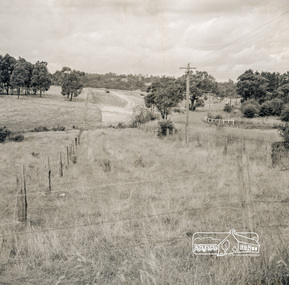
Photograph, Looking east from the northern side of Lower Plenty Road (opposite Bannockburn Road) as it crosses the Watsonia Drain, Viewbank, c.1965, 1965c
Transmission power lines visible in distance behind the Lower Plenty Hotel (in centre upper) and parts of Heidelberg Golf Club. In the foreground a bulldozer can be seen commencing roadworks for the re-alignment of Lower Plenty Road for the new Lower Plenty Bridge crossing.Medium format 120 6x6 black and white negative film, 1 frameheidelberg golf club, lower plenty, lower plenty hotel, road construction, viewbank, watsonia drain