Showing 4547 items matching "historical map"
-
 Whitehorse Historical Society Inc.
Map, Springfield Road, Blackburn, 1924
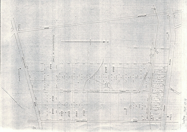
Plan of subdivision, parts of Crown Portions 73 and 74, parish of Nunawading, County of Bourke.Plan of subdivision, parts of Crown Portions 73 and 74, parish of Nunawading, County of Bourke. Passed by MMBW 24 May 1924. Subdivision not implemented. Originally owned by Leonard Sherwin Bayley, then by Edward Henry Pearce, then by Ron Pearce. Part compulsorily acquired as site for Blackburn High School. With historical notes by Ron Pearce.Plan of subdivision, parts of Crown Portions 73 and 74, parish of Nunawading, County of Bourke. bayley, leonard sherwin, pearce, edward h, pearce, ronald harry, orchards, blackburn high school, north blackburn square shopping centre -
Whitehorse Historical Society Inc.
Map, Council facilities, c1992
Map of City of Nunawading with parks and facilities marked and indexed.Map of City of Nunawading with parks and facilities marked and indexed.Map of City of Nunawading with parks and facilities marked and indexed.recreation facilities, city of nunawading, maternal and child health centres, senior citizens centres, parks and reserves, libraries, child care -
 Whitehorse Historical Society Inc.
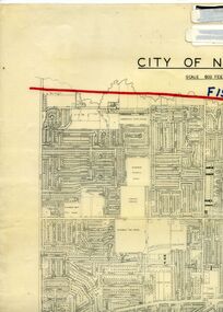
Legal record - Map, F19 freeway, 1/12/1977 12:00:00 AM
Approximate alignments of F19(Eastern) Freeway, F9 and Scoresby Freeway, marked on 1973 edition of City of Nunawading map,Approximate alignments of F19(Eastern) Freeway, F9 and Scoresby Freeway, marked on 1973 edition of City of Nunawading map, Scale 800 ft = 1 inch.Approximate alignments of F19(Eastern) Freeway, F9 and Scoresby Freeway, marked on 1973 edition of City of Nunawading map, freeways, city of nunawading, eastern freeway, scoresby freeway -
Whitehorse Historical Society Inc.
Map, Community facilities, 1/10/1981 12:00:00 AM
Map of the City of Nunawading showing community facilitiesMap of the City of Nunawading showing community facilitiesMap of the City of Nunawading showing community facilitiesparks and reserves, city of nunawading, schools, senior citizens centres, maternal and child health centres, post offices, police stations, preschools -
Whitehorse Historical Society Inc.
Map, Parks and recreation facilities, 1/06/1995 12:00:00 AM
Map of the City of Whitehorse with parks and reserves marked and indexedMap of the City of Whitehorse with parks and reserves marked and indexed.Map of the City of Whitehorse with parks and reserves marked and indexedcity of whitehorse, parks and reserves, bicycle paths, recreation facilities, blackburn, blackburn north, blackburn south, burwood east, forest hill, mitcham, nunawading, vermont, vermont south -
Whitehorse Historical Society Inc.
Map, Waverley, c1985
Map of Waverley, including Box Hill Soiuth, Blackburn South, Vermont, Vermont South, Burwood East, Burwood, Ashburton, Mount Waverley, Glen Waverley, Oakleigh South, Clayton North and Mulgrave.Map of Waverley, including Box Hill Soiuth, Blackburn South, Vermont, Vermont South, Burwood East, Burwood, Ashburton, Mount Waverley, Glen Waverley, Oakleigh South, Clayton North and Mulgrave. UBD map issued by Nicholls Gledhill Real Estate Agents. Scale 1:50,000.Map of Waverley, including Box Hill Soiuth, Blackburn South, Vermont, Vermont South, Burwood East, Burwood, Ashburton, Mount Waverley, Glen Waverley, Oakleigh South, Clayton North and Mulgrave. blackburn south, burwood east, vermont, vermont south, forest hill -
Whitehorse Historical Society Inc.
Map, City of Whitehorse, 1/03/1995 12:00:00 AM
Map of City of Whitehorse prepared by Richard Meloni showing roads, railways, creeks.Map of City of Whitehorse prepared by Richard Meloni showing roads, railways, creeks.Map of City of Whitehorse prepared by Richard Meloni showing roads, railways, creeks.blackburn, nunawading, blackburn south, mitcham, vermont, vermont south, blackburn north, forest hill, burwood east, city of whitehorse -
Whitehorse Historical Society Inc.
Map, City of Nunawading, c1975
Map of City of Nunawading, showing location of 186 parks and reserves.Map of City of Nunawading, showing location of 186 parks and reserves. Scale 1:10,000 with list of streets and their map coordinates.Map of City of Nunawading, showing location of 186 parks and reserves. city of nunawading, parks and reserves -
Whitehorse Historical Society Inc.
Map, Heritage overlay map, 1/02/1999 12:00:00 AM
City of Whitehorse heritage review : Heritage overlay map.City of Whitehorse heritage review : Heritage overlay map.City of Whitehorse heritage review : Heritage overlay map.city of whitehorse, historic buildings, blackburn, blackburn south, blackburn north, mitcham, nunawading, forest hill, vermont, vermont south, burwood east -
Whitehorse Historical Society Inc.
Map, Shire of Blackburn and Mitcham, 1938
Plan of Shire of Blackburn and Mitcham showing sections and lot numbers. Scale 8 chains to 1 inch.Plan of Shire of Blackburn and Mitcham showing sections and lot numbers. Scale 8 chains to 1 inch.Plan of Shire of Blackburn and Mitcham showing sections and lot numbers. Scale 8 chains to 1 inch.shire of blackburn and mitcham, blackburn, blackburn north, blackburn south, burwood east, forest hill, mitcham, nunawading, vermont, vermont south -
Whitehorse Historical Society Inc.
Map, Shire of Blackburn and Mitcham, c1935
Map of Shire of Blackburn and Mitcham showing refuse collection days, sections and lot numbers. Scale 8 chains to 1 inch.Map of Shire of Blackburn and Mitcham showing refuse collection days, sections and lot numbers. Scale 8 chains to 1 inch.Map of Shire of Blackburn and Mitcham showing refuse collection days, sections and lot numbers. Scale 8 chains to 1 inch.shire of blackburn and mitcham, blackburn, blackburn north, blackburn south, burwood east, forest hill, mitcham, nunawading, vermont, vermont south -
Whitehorse Historical Society Inc.
Map, City of Nunawading, 1/02/1973 12:00:00 AM
Map of City of Nunawading shoeing open creeks or watercourses and watercourses that have been piped.Map of City of Nunawading shoeing open creeks or watercourses and watercourses that have been piped. Scale: 800 feet =1 inchMap of City of Nunawading shoeing open creeks or watercourses and watercourses that have been piped. blackburn, blackburn north, blackburn south, burwood east, forest hill, mitcham, nunawading, vermont, vermont south, city of nunawading, creeks -
Whitehorse Historical Society Inc.
Map, Shire of Blackburn and Mitcham, 10/10/1939 update
Map of Shire of Blackburn and Mitcham showing Departmental ball hydrants and departmental pillar ball hydrants.Map of Shire of Blackburn and Mitcham showing Departmental ball hydrants and departmental pillar ball hydrants. Scale 8 chains to 1 inch.Map of Shire of Blackburn and Mitcham showing Departmental ball hydrants and departmental pillar ball hydrants.shire of blackburn and mitcham, fire hydrants, blackburn, blackburn north, blackburn south, burwood east, forest hill, mitcham, nunawading, vermont, vermont south -
Whitehorse Historical Society Inc.
Map, Melbourne and suburbs, 1923
Section of map 'Melbourne and Suburbs' compiled at the Department of Lands and Survey, Melbourne by E. S. Hilcke, March 1923, reprinted 1940.Section of map 'Melbourne and Suburbs' compiled at the Department of Lands and Survey, Melbourne by E. S. Hilcke, March 1923, reprinted 1940. Scale 40 chains: 1 inch. - Shire of Blackburn and MitchamSection of map 'Melbourne and Suburbs' compiled at the Department of Lands and Survey, Melbourne by E. S. Hilcke, March 1923, reprinted 1940.department of lands and surve, melbourne and suburbs -
 Whitehorse Historical Society Inc.
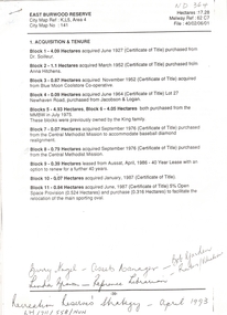
Letter - Correspondence, East Burwood Reserve, 1993
Various documents relating to the establishment of East Burwood ReserveVarious documents relating to the establishment of East Burwood Reserve including acquisition of land, details, plans, locality map, news cuttings and photographs. Appears to be copy of Nunawading City Council File April 1993Various documents relating to the establishment of East Burwood Reserve sportsgrounds, east burwood reserve, soilleur (dr), hitchens, anna, blue moon fruit co-operative ltd., jacobson and logan, king family, central methodist mission, aussat, tally ho, sewart, bill -
 Whitehorse Historical Society Inc.
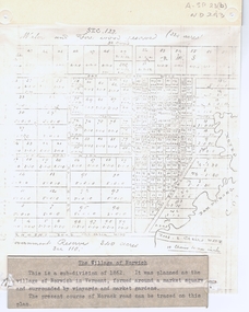
Document, The Village of Norwich, C1862
Map showing the planned village of NorwichMap showing the planned village of Norwich in Vermont about 1862Map showing the planned village of Norwichland settlement, morack road, vermont south, barkly street, vermont, george street, william street -
Whitehorse Historical Society Inc.
Pamphlet - Advertising brochure, Kenmare Heights Estate, 1927
Clearing sale by public auction , Saturday 26/11/1927 of Kenmare Heights Estate Mont Albert, Situated between Belmore Road, Boundary Road, Strabane Avenue, Union Road and Dunloe Avenue. Advertising material and mapknight & harwood auctioneer, auctions, kenmare height estate, union road mont albert, belmore road, relowe crescent, whitehorse road, evalina street, francesca street, mozelle street, dunloe avenue -
Whitehorse Historical Society Inc.
Pamphlet, Go bush in Nunawading, 1986
A leaflet with names, locations and map of bushland parks in Nunawading.A leaflet with names, locations and map of bushland parks in Nunawading.A leaflet with names, locations and map of bushland parks in Nunawading.city of nunawading. parks and recreation department., parks and reserves -
 Whitehorse Historical Society Inc.
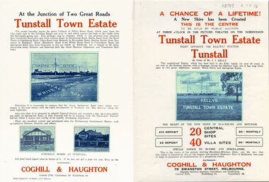
Legal record - Document, Tunstall Town Estate
Land subdivision at Tunstall 1926 bounded by Springvale Road, Whitehorse Road, Railway Parade.Land subdivision at Tunstall 1926 bounded by Springvale Road, Whitehorse Road, Railway Parade. Original in Haughton Maps LaTrobe LibraryLand subdivision at Tunstall 1926 bounded by Springvale Road, Whitehorse Road, Railway Parade. land subdivision, springvale road, nunawading, railway parade, kelly, j, nunawading state school, no. 4190, shire of blackburn and mitcham, whitehorse road, silver grove, glendale street -
 Whitehorse Historical Society Inc.
Document, Map of Vermont & Mitcham
Copy of map showing land in Mitcham and Vermont areasCopy of map showing land in Mitcham and Vermont areas bounded by Whitehorse , Mitcham, Canterbury and Heatherdale roads.Copy of map showing land in Mitcham and Vermont areasland subdivision, whitehorse road, mitcham, heatherdale road, canterbury road, vermont, mitcham road -
Whitehorse Historical Society Inc.
Pamphlet, Schwerkolt Cottage Mitcham
A pamphlet issued by City of NunawadingA pamphlet issued by City of Nunawading on Schwerkolt Cottage with photographs and location map.A pamphlet issued by City of Nunawading schwerkolt cottage, city of nunawading -
 Whitehorse Historical Society Inc.
Document - Leaflet, Blackburn Land Sale, 19/11/1910 12:00:00 AM
Pamphlets showing sale of land Gardenia Street, Blackburn and surrounding streets.Pamphlets showing sale of land Gardenia Street, Blackburn and surrounding streets. Schedule of prices. Hand drawn mapPamphlets showing sale of land Gardenia Street, Blackburn and surrounding streets.blackburn township estate co. ltd., blackburn railway station, south parade blackburn, laburnum street, blackburn, the avenue blackburn, fuschia street blackburn, linum street blackburn, main street, t.r.b.morton. & son, land subdivision -
Whitehorse Historical Society Inc.
Map, Austral Park, Mitcham, 1907
Advertisement for subdivision of area south of Mitcham Railway Station.Advertisement for subdivision of area south of Mitcham Railway Station. Includes area now site of Mitcham reservoir. Some details of main buildings in Mitcham and Vermont.Advertisement for subdivision of area south of Mitcham Railway Station. land subdivision, mitcham, mitcham road, mitcham, calcutta street, mitcham, delhi street, mitcham, meerut street, mitcham, simla street, mitcham, agra street, mitcham, lucknow street, mitcham, mitcham reservoir, austral park mitcham -
Whitehorse Historical Society Inc.
Map, Applied for the Roman Catholic Church, 1848
Photocopy of manuscript map inscribed 'Reserve 40 Parish of Nunawading'.Photocopy of manuscript map inscribed 'Reserve 40 Parish of Nunawading'. Streets not named. Note on verso: Site reserved for Roman Catholic Church in Nunawading c1848 (Cr Riversdale and Warrigal Roads)Photocopy of manuscript map inscribed 'Reserve 40 Parish of Nunawading'. churches, catholic church, riversdale road, surrey hills, warrigal road, surrey hills -
Whitehorse Historical Society Inc.
Map, Plan of the Parish of Nunawading, 1853
Photocopy of map showing names of selectors, also list of references to the corners of allotments.Photocopy of map showing names of selectors, also list of references to the corners of allotments. Note on verso:'Gardiners Creek, Ballyshanassey township surveyed by H. Parmein, Surveyor General's Office Nov 30, 1853 also Reference to the Corners of allotments' (Plan 428)Photocopy of map showing names of selectors, also list of references to the corners of allotments. land subdivision, gardiners creek, ballyshanassy, parmein, h, burwood east, maps -
Whitehorse Historical Society Inc.
Map, Site for Wesleyan Church, Nunawading, 1855
Photocopy of manuscript map showing names of landholders.Photocopy of manuscript map showing names of landholders. Note on verso: Plan of allotments in the City of Melbourne appropriated to the Wesleyans. Site for Wesleyan Church, Nunawading 1848 (Corner of Burwood and Elgar Roads - S of Burwood, W of Elgar)Photocopy of manuscript map showing names of landholders. churches, wesleyan church, burwood, burwood road, burwood, elgar road, burwood, maps -
Whitehorse Historical Society Inc.
Map, The Parish of Nunawading, 1853
Photocopy of manuscript plan with allotments numbered and some named.Photocopy of manuscript plan with allotments numbered and some named. Note on verso: The Parish of Nunawading in the County of Bourke; lithographed at the Surveyor General's office by J.Jones Jan 18th 1853. Endorsed Sale Plan 271. Dray tracks, water holes and terrain indicated.Photocopy of manuscript plan with allotments numbered and some named. land subdivision, maps, parish of nunawading, jones, j -
Whitehorse Historical Society Inc.
Map, Parish of Nunawading, 1853
Photocopy of manuscript map with allotments numbered and named.Photocopy of manuscript map with allotments numbered and named. Note on verso: Parish of Nunawading, County of Bourke. Gardiners Creek, Ballyshanassey Township, surveyed by H. Parmein, Surveyor General's office, Nov 30th 1853 [enlargement of ND2801, no list of corner references]Photocopy of manuscript map with allotments numbered and named. maps, gardiners creek, ballyshanassy, burwood east, parmein, h -
Whitehorse Historical Society Inc.
Map, Boroondara, Nunawading, 1853
Map of section of Parishes of Boroondara and NunawadingMap of section of Parishes of Boroondara and Nunawading with allotments numbered and named. Note on verso: Boroondara and Nunawading c1853.Map of section of Parishes of Boroondara and Nunawading maps, parish of nunawading, parish of boroondara -
Whitehorse Historical Society Inc.
Map, Parish of Boroondara and Parish of Nunawading, 1850
Photocopy of manuscript map.Photocopy of manuscript map. Note on verso: Plan of 22 portions marked in the Parish of Boroondara and 6 portions in the Parish of Nunawading c1850Photocopy of manuscript map. maps, parish of boroondara, parish of nunawading