Showing 123968 items matching "main-road"
-
 Eltham District Historical Society Inc
Photograph, Liz Pidgeon, Heritage Excursion; Eltham Lower Park Walk and Talk, 1 July 2017, 1 July 2017
Faded Information Board - Wetland Wildlife situated in Lenister Wetlands Newsletter No., 234, June 2017 Heritage Excursion - Saturday 1st July - Eltham Lower Park - Walk and Talk Eltham Lower Park has played an important part in the history of our area since the early days of European settlement when it was used by local residents as an informal racecourse. Prior to that its location at the junction of the Diamond Creek and the Yarra River made it an important meeting place for the Wurundjeri people. The park combines formal elements and sporting facilities with remnant bushland that is of environmental significance. It is home to sporting and horse riding clubs, popular play spaces and the Diamond Valley Miniature Railway, which attracts large numbers of visitors. The park will be the venue for our July excursion which will comprise a walk of about 3.5 km around the park and adjacent areas. Along the way we will discuss the history and natural history of the area. The path along the creek and the river provides a pleasant and scenic walk. This walk on Saturday 1st July is about 3.5 km in length and will take 2 to 2.5 hours. It will start at 2pm at the Main Road car park at the front of the park. (Melway ref 21 H 10). Born Digitalheritage excursion, activities, eltham district historical society, eltham lower park, information board -
 Eltham District Historical Society Inc
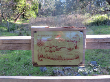
Photograph, Liz Pidgeon, Heritage Excursion; Eltham Lower Park Walk and Talk, 1 July 2017, 1 July 2017
Information Board : Not just a pretty place Newsletter No., 234, June 2017 Heritage Excursion - Saturday 1st July - Eltham Lower Park - Walk and Talk Eltham Lower Park has played an important part in the history of our area since the early days of European settlement when it was used by local residents as an informal racecourse. Prior to that its location at the junction of the Diamond Creek and the Yarra River made it an important meeting place for the Wurundjeri people. The park combines formal elements and sporting facilities with remnant bushland that is of environmental significance. It is home to sporting and horse riding clubs, popular play spaces and the Diamond Valley Miniature Railway, which attracts large numbers of visitors. The park will be the venue for our July excursion which will comprise a walk of about 3.5 km around the park and adjacent areas. Along the way we will discuss the history and natural history of the area. The path along the creek and the river provides a pleasant and scenic walk. This walk on Saturday 1st July is about 3.5 km in length and will take 2 to 2.5 hours. It will start at 2pm at the Main Road car park at the front of the park. (Melway ref 21 H 10). Born Digitalelection day, heritage excursion, activities, eltham district historical society, eltham lower park, information board -
 Eltham District Historical Society Inc
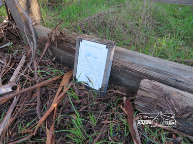
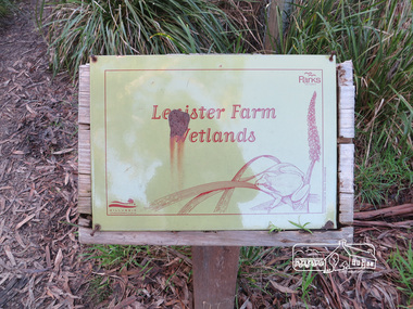
Photograph, Liz Pidgeon, Heritage Excursion; Eltham Lower Park Walk and Talk, 1 July 2017, 1 July 2017
Information Board with rust - Lenister Farm Wetlands Newsletter No., 234, June 2017 Heritage Excursion - Saturday 1st July - Eltham Lower Park - Walk and Talk Eltham Lower Park has played an important part in the history of our area since the early days of European settlement when it was used by local residents as an informal racecourse. Prior to that its location at the junction of the Diamond Creek and the Yarra River made it an important meeting place for the Wurundjeri people. The park combines formal elements and sporting facilities with remnant bushland that is of environmental significance. It is home to sporting and horse riding clubs, popular play spaces and the Diamond Valley Miniature Railway, which attracts large numbers of visitors. The park will be the venue for our July excursion which will comprise a walk of about 3.5 km around the park and adjacent areas. Along the way we will discuss the history and natural history of the area. The path along the creek and the river provides a pleasant and scenic walk. This walk on Saturday 1st July is about 3.5 km in length and will take 2 to 2.5 hours. It will start at 2pm at the Main Road car park at the front of the park. (Melway ref 21 H 10). Born Digitalelection day, heritage excursion, activities, eltham district historical society, eltham lower park, information board, lenister farm wetlands -
 Eltham District Historical Society Inc
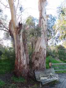
Photograph, Liz Pidgeon, Heritage Excursion; Eltham Lower Park Walk and Talk, 1 July 2017, 1 July 2017
Connecting trunks of gum trees near the viewing platform on the Diamond Creek. Newsletter No., 234, June 2017 Heritage Excursion - Saturday 1st July - Eltham Lower Park - Walk and Talk Eltham Lower Park has played an important part in the history of our area since the early days of European settlement when it was used by local residents as an informal racecourse. Prior to that its location at the junction of the Diamond Creek and the Yarra River made it an important meeting place for the Wurundjeri people. The park combines formal elements and sporting facilities with remnant bushland that is of environmental significance. It is home to sporting and horse riding clubs, popular play spaces and the Diamond Valley Miniature Railway, which attracts large numbers of visitors. The park will be the venue for our July excursion which will comprise a walk of about 3.5 km around the park and adjacent areas. Along the way we will discuss the history and natural history of the area. The path along the creek and the river provides a pleasant and scenic walk. This walk on Saturday 1st July is about 3.5 km in length and will take 2 to 2.5 hours. It will start at 2pm at the Main Road car park at the front of the park. (Melway ref 21 H 10). Born Digitalheritage excursion, activities, eltham district historical society, eltham lower park, gum trees -
 Eltham District Historical Society Inc
Photograph, Liz Pidgeon, Heritage Excursion; Eltham Lower Park Walk and Talk, 1 July 2017, 1 July 2017
Information Board titled: Family Nature Trail - History of the land of Lower Eltham Park Newsletter No., 234, June 2017 Heritage Excursion - Saturday 1st July - Eltham Lower Park - Walk and Talk Eltham Lower Park has played an important part in the history of our area since the early days of European settlement when it was used by local residents as an informal racecourse. Prior to that its location at the junction of the Diamond Creek and the Yarra River made it an important meeting place for the Wurundjeri people. The park combines formal elements and sporting facilities with remnant bushland that is of environmental significance. It is home to sporting and horse riding clubs, popular play spaces and the Diamond Valley Miniature Railway, which attracts large numbers of visitors. The park will be the venue for our July excursion which will comprise a walk of about 3.5 km around the park and adjacent areas. Along the way we will discuss the history and natural history of the area. The path along the creek and the river provides a pleasant and scenic walk. This walk on Saturday 1st July is about 3.5 km in length and will take 2 to 2.5 hours. It will start at 2pm at the Main Road car park at the front of the park. (Melway ref 21 H 10). Born Digitalheritage excursion, activities, eltham district historical society, eltham lower park, information board, trail -
 Eltham District Historical Society Inc
Photograph, Liz Pidgeon, Heritage Excursion; Eltham Lower Park Walk and Talk, 1 July 2017, 1 July 2017
Information board titled "erosion control" including a photo and causes produced by the Shire of Nillumbik Newsletter No., 234, June 2017 Heritage Excursion - Saturday 1st July - Eltham Lower Park - Walk and Talk Eltham Lower Park has played an important part in the history of our area since the early days of European settlement when it was used by local residents as an informal racecourse. Prior to that its location at the junction of the Diamond Creek and the Yarra River made it an important meeting place for the Wurundjeri people. The park combines formal elements and sporting facilities with remnant bushland that is of environmental significance. It is home to sporting and horse riding clubs, popular play spaces and the Diamond Valley Miniature Railway, which attracts large numbers of visitors. The park will be the venue for our July excursion which will comprise a walk of about 3.5 km around the park and adjacent areas. Along the way we will discuss the history and natural history of the area. The path along the creek and the river provides a pleasant and scenic walk. This walk on Saturday 1st July is about 3.5 km in length and will take 2 to 2.5 hours. It will start at 2pm at the Main Road car park at the front of the park. (Melway ref 21 H 10). Born Digitalheritage excursion, activities, eltham district historical society, eltham lower park, erosion, information board -
 Eltham District Historical Society Inc
Photograph, Liz Pidgeon, Heritage Excursion; Eltham Lower Park Walk and Talk, 1 July 2017, 1 July 2017
Plaque explaining "Indigenous grasses of Nillumbik" from the Shire of Nillumbik Newsletter No., 234, June 2017 Heritage Excursion - Saturday 1st July - Eltham Lower Park - Walk and Talk Eltham Lower Park has played an important part in the history of our area since the early days of European settlement when it was used by local residents as an informal racecourse. Prior to that its location at the junction of the Diamond Creek and the Yarra River made it an important meeting place for the Wurundjeri people. The park combines formal elements and sporting facilities with remnant bushland that is of environmental significance. It is home to sporting and horse riding clubs, popular play spaces and the Diamond Valley Miniature Railway, which attracts large numbers of visitors. The park will be the venue for our July excursion which will comprise a walk of about 3.5 km around the park and adjacent areas. Along the way we will discuss the history and natural history of the area. The path along the creek and the river provides a pleasant and scenic walk. This walk on Saturday 1st July is about 3.5 km in length and will take 2 to 2.5 hours. It will start at 2pm at the Main Road car park at the front of the park. (Melway ref 21 H 10). Born Digitalheritage excursion, activities, eltham district historical society, eltham lower park, information board, indigenous grass, indigenous plants -
 Eltham District Historical Society Inc
Photograph, Liz Pidgeon, Heritage Excursion; Eltham Lower Park Walk and Talk, 1 July 2017, 1 July 2017
Area planted with indigenous plants with information sign board Newsletter No., 234, June 2017 Heritage Excursion - Saturday 1st July - Eltham Lower Park - Walk and Talk Eltham Lower Park has played an important part in the history of our area since the early days of European settlement when it was used by local residents as an informal racecourse. Prior to that its location at the junction of the Diamond Creek and the Yarra River made it an important meeting place for the Wurundjeri people. The park combines formal elements and sporting facilities with remnant bushland that is of environmental significance. It is home to sporting and horse riding clubs, popular play spaces and the Diamond Valley Miniature Railway, which attracts large numbers of visitors. The park will be the venue for our July excursion which will comprise a walk of about 3.5 km around the park and adjacent areas. Along the way we will discuss the history and natural history of the area. The path along the creek and the river provides a pleasant and scenic walk. This walk on Saturday 1st July is about 3.5 km in length and will take 2 to 2.5 hours. It will start at 2pm at the Main Road car park at the front of the park. (Melway ref 21 H 10). Born Digitalheritage excursion, activities, eltham district historical society, eltham lower park, indigenous plants -
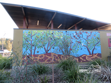 Eltham District Historical Society Inc
Photograph, Liz Pidgeon, Heritage Excursion; Eltham Lower Park Walk and Talk, 1 July 2017, 1 July 2017
Mural artwork painted on the wall divider of the new toilet block at Eltham Lower Park Newsletter No., 234, June 2017 Heritage Excursion - Saturday 1st July - Eltham Lower Park - Walk and Talk Eltham Lower Park has played an important part in the history of our area since the early days of European settlement when it was used by local residents as an informal racecourse. Prior to that its location at the junction of the Diamond Creek and the Yarra River made it an important meeting place for the Wurundjeri people. The park combines formal elements and sporting facilities with remnant bushland that is of environmental significance. It is home to sporting and horse riding clubs, popular play spaces and the Diamond Valley Miniature Railway, which attracts large numbers of visitors. The park will be the venue for our July excursion which will comprise a walk of about 3.5 km around the park and adjacent areas. Along the way we will discuss the history and natural history of the area. The path along the creek and the river provides a pleasant and scenic walk. This walk on Saturday 1st July is about 3.5 km in length and will take 2 to 2.5 hours. It will start at 2pm at the Main Road car park at the front of the park. (Melway ref 21 H 10). Born Digitalheritage excursion, activities, eltham district historical society, eltham lower park, mural, tiolet block -
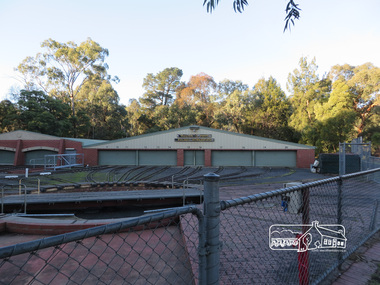 Eltham District Historical Society Inc
Photograph, Liz Pidgeon, Heritage Excursion; Eltham Lower Park Walk and Talk, 1 July 2017, 1 July 2017
Diamond Valley Miniature Railway Sheds Newsletter No., 234, June 2017 Heritage Excursion - Saturday 1st July - Eltham Lower Park - Walk and Talk Eltham Lower Park has played an important part in the history of our area since the early days of European settlement when it was used by local residents as an informal racecourse. Prior to that its location at the junction of the Diamond Creek and the Yarra River made it an important meeting place for the Wurundjeri people. The park combines formal elements and sporting facilities with remnant bushland that is of environmental significance. It is home to sporting and horse riding clubs, popular play spaces and the Diamond Valley Miniature Railway, which attracts large numbers of visitors. The park will be the venue for our July excursion which will comprise a walk of about 3.5 km around the park and adjacent areas. Along the way we will discuss the history and natural history of the area. The path along the creek and the river provides a pleasant and scenic walk. This walk on Saturday 1st July is about 3.5 km in length and will take 2 to 2.5 hours. It will start at 2pm at the Main Road car park at the front of the park. (Melway ref 21 H 10). Born Digitalheritage excursion, activities, eltham district historical society, eltham lower park, diamond valley miniature railway -
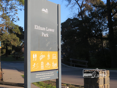 Eltham District Historical Society Inc
Photograph, Liz Pidgeon, Heritage Excursion; Eltham Lower Park Walk and Talk, 1 July 2017, 1 July 2017
Eltham Lower Park sign with Council logo at the entrance of the Park. Newsletter No., 234, June 2017 Heritage Excursion - Saturday 1st July - Eltham Lower Park - Walk and Talk Eltham Lower Park has played an important part in the history of our area since the early days of European settlement when it was used by local residents as an informal racecourse. Prior to that its location at the junction of the Diamond Creek and the Yarra River made it an important meeting place for the Wurundjeri people. The park combines formal elements and sporting facilities with remnant bushland that is of environmental significance. It is home to sporting and horse riding clubs, popular play spaces and the Diamond Valley Miniature Railway, which attracts large numbers of visitors. The park will be the venue for our July excursion which will comprise a walk of about 3.5 km around the park and adjacent areas. Along the way we will discuss the history and natural history of the area. The path along the creek and the river provides a pleasant and scenic walk. This walk on Saturday 1st July is about 3.5 km in length and will take 2 to 2.5 hours. It will start at 2pm at the Main Road car park at the front of the park. (Melway ref 21 H 10). Born Digitalelection day, heritage excursion, activities, eltham district historical society, eltham lower park, sign -
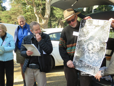 Eltham District Historical Society Inc
Photograph, Liz Pidgeon, Heritage Excursion; Eltham Lower Park Walk and Talk, 1 July 2017, 1 July 2017
Local historian Russell Yeoman with EDHS President Jim Connor Newsletter No., 234, June 2017 Heritage Excursion - Saturday 1st July - Eltham Lower Park - Walk and Talk Eltham Lower Park has played an important part in the history of our area since the early days of European settlement when it was used by local residents as an informal racecourse. Prior to that its location at the junction of the Diamond Creek and the Yarra River made it an important meeting place for the Wurundjeri people. The park combines formal elements and sporting facilities with remnant bushland that is of environmental significance. It is home to sporting and horse riding clubs, popular play spaces and the Diamond Valley Miniature Railway, which attracts large numbers of visitors. The park will be the venue for our July excursion which will comprise a walk of about 3.5 km around the park and adjacent areas. Along the way we will discuss the history and natural history of the area. The path along the creek and the river provides a pleasant and scenic walk. This walk on Saturday 1st July is about 3.5 km in length and will take 2 to 2.5 hours. It will start at 2pm at the Main Road car park at the front of the park. (Melway ref 21 H 10). Born Digitalheritage excursion, activities, eltham district historical society, eltham lower park, russell yeoman, jim connor -
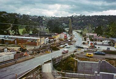 Greensborough Historical Society
Photograph - Digital Image, Main Street upgrade 1960s, 1978c
Photograph of upgrade works in lower Main Street area, taken in the late 1960s. Shows construction of rail bridge and Main Street.Digital copy of colour photographmain street greensborough -
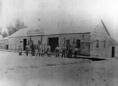 Stawell Historical Society Inc
Photograph, W & J Heal Blacksmiths & Wheelwrights in Upper Main Street with workmen at the front. Three photographs at same time
Group of workmen in front of W & J Heals Blacksmiths and Wheelwrights Upper Main Street located at extreme top of Main Street.Three similar photographs of Blacksmiths and Wheelwrights Coachbuilder and Painter building. stawell business -
 Eltham District Historical Society Inc
Photograph, Barry Philp, Jim Archbold's house in Ingrams Road, Research, c.1969
Jim Archbolds house in Ingrams Road. Photographer Barry Philp lived at 1569 Main Road directly opposite the school. "The photo looks like it was taken from our place looking northwest to Jim's."research (vic.), house, ingrams road, jim archbold -
 Kew Historical Society Inc
Photograph - Corner of Normanby and Parkhill Roads, Kew, 1926
The section of Normanby Road, Kew from Cotham Road to Parkhill Road was officially gazetted in 1865. The part of Normanby Road between Parkhill Road and Harp Road was gazetted ten years later in 1875. Parkhill (sometimes Park Hill) Road East and Parkhill Road West were both gazetted in 1865.Original, black and white positive print of a photograph taken from a house in Normanby Road across the road to another house on the corner of Normanby and Parkhill Roads. The hills of Kew can be seen in the background. The main house in the photo is 57 Normanby Road.Inscribed verso: "Normanby Rds and Parkhill Rds corner " normanby road -- kew (vic.), parkhill road -- kew (vic.), 57 normanby road -- kew (vic.) -
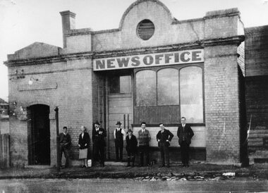
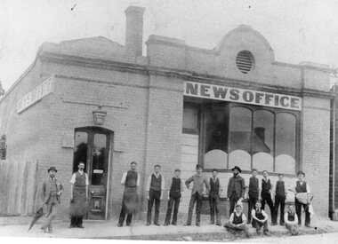 Stawell Historical Society Inc
Photograph, Stawell Pleasant Creek News Newspaper Office in Main Street corner of Layzell Street
Staff in front of Stawell News Newspaper Office 191 Main Street Stawell. 1886. NE Corner of Main Street and Layzell Street. -
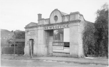 Stawell Historical Society Inc
Photograph, Stawell Pleasant Creek News Newspaper Office in Main Street corner of Layzell Street c1960
Stawell News Newspaper Office 191 Main Street Stawell. NE Corner of Main Street and Layzell Street in derelict state. C1960 -
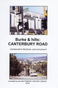 Ringwood and District Historical Society
Book, Burke & Hills: Canterbury Road Camberwell to Montrose, by Heathmont History Group - 2014
Soft cover book of 40 pages with spiral wire spine. Compilation of images and descriptive timeline of the geology, geography and European settlement history of Canterbury Road.Soon after beginning at Burke Road Camberwell, Canterbury Road moves into the gentle hills of Canterbury, then on to Surrey Hills, Box Hill and Forest Hill. Further along past these three "hills" come three "monts" - Vermont, Heathmont and at its other end, Montrose, by then in the foothills of the Dandenongs. Grand homes and churches at one end, major and minor shopping centres along the 25km, factories now where farms were, big box stores, fast food outlets, train stations, resrvoir, traffic, residential stretches, modern apartment blocks, parklands, child-minding centres, sporting ovals, a sewage farm, hotels, quarries, commercial developments, plant nurseries, a golf course, bridges, memorials, Asian food shops, telecommunication towers, bushland, creeks, crossroads, traffic lights, mansions, orchards, swamps ... Delaneys Road, renamed Canterbury Road after a 19th century Victorian Governor, is a fascinating study in land use and history as suburban Melbourne has continually diversified and pushed outwards. Compiled by Heathmont History Group, Rita James, Les Prato, Betty Colbert, Jeff Leipold, Gerry Robinson (convenor). -
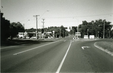 Ringwood and District Historical Society
Photograph-B&W, Joan Walker, East Ringwood 2000-Taken at the cnr: Mount Dandenong Road and Dublin Road (Maroondah Hospital in the distance), 2000
East Ringwood 2000-Taken at the cnr: Mount Dandenong Road and Dublin Road (Maroondah Hospital in the distance.- B&W Photo from Album 6501 -
 Ringwood and District Historical Society
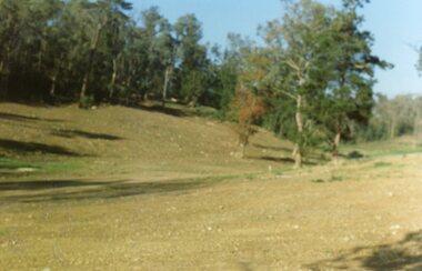
Photograph, Site of the main body of Loughnan's Lake, North Ringwood on 10 June 1978. the rope tree was on the slope, far left
E550 N6 Part of a 51-photo record of the development of the "Kubis" Estate, Ringwood North, including road works to Debbie Place, Kubis Drive, Werac Drive, Manuelo Drive, Iluka Place and Glenvale Road. From the Jack Lundy Clarke collection. -
 Ringwood and District Historical Society
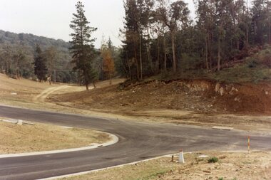
Photograph, Kubis Estate, North Ringwood in April 1978. Looking west across Kubis and Werac Drives over the full length of Loughnan's Lake site. Main pool was behind the lone pine
E548 N29 Part of a 51-photo record of the development of the "Kubis" Estate, Ringwood North, including road works to Debbie Place, Kubis Drive, Werac Drive, Manuelo Drive, Iluka Place and Glenvale Road. From the Jack Lundy Clarke collection. -
 Marysville & District Historical Society
Photograph (Item) - Black and white photograph, c1940s
A black and white photograph of the Marysville-Buxton Road in Marysville in Victoria.A black and white photograph of the Marysville-Buxton Road in Marysville in Victoria. This road leads from Murchison Street, which is the main street, in Marysville in Victoria.Buxton Roadmarysville-buxton road, marysville, victoria, murchison street -
 Vision Australia
Photograph - Image, St Kilda Road building in 2010, 6/1/2010
In 2007, Vision Australia sold it's iconic 557-563 St Kilda Road site. The historic bluestone building was in need of renovation and repair, had limited space for staff and clients and with more demand for services in suburban and regional areas, did not meet the needs of the national organisation. The purchaser was mainly interested in the Ormond Hall section, which they sub-divided off and sold to the tenant of the Belgian Beer Cafe. The remainder of the site was then sold on to another developer. Unable to quickly proceed with their plans on developing the site for residential buildings, the site fell into some disrepair in the interim which was when these images were taken. Later the site was sold again and residential buildings now occupy part of the block. 20 images taken of and from St Kilda Road buildingroyal victorian institute for the blind, buildings, myer house, ferguson and urie -
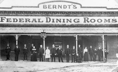 Stawell Historical Society Inc
Photograph, Berndt’s Federal Dining Rooms in Upper Main Street Big Hill c1900
Berndt’s Federal Dining Rooms upper Main Street Big Hill beside Forester Hotel on corner of Main Street and Patrick Street c1900stawell -
 Stawell Historical Society Inc
Photograph, Stawell Pleasant Creek News Newspaper Office in Main Street corner of Layzell Street
Staff in front of Stawell Pleasant Creek News Newspaper Office 191 Main Street Stawell. NE Corner of Main Street and Layzell Street stawell -
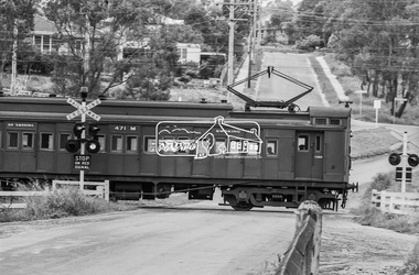 Eltham District Historical Society Inc
Photograph, Single Motor Carriage 471M Tait (Red Rattler) train passing through the level crossing at Wattletree Road, Eltham, c.1970, 1970
Note the blue stone edging surrounding the grassy island in the intersection. This stone was originally part of the blue stone lock-up situated behind the Police Station and residence at 728 Main Road (present day Local History Centre and home to Eltham District Historical Society). Following a redesign of the intersection the stone was again relocated back to 728-730 Main Road for use as garden edging.Digital TIFF file Scan of 35mm Ilford HP4 black and white transparency471m, 728 main road, local history centre, lockup, police station, red rattler, single motor carriage, tait train, wattletree road -
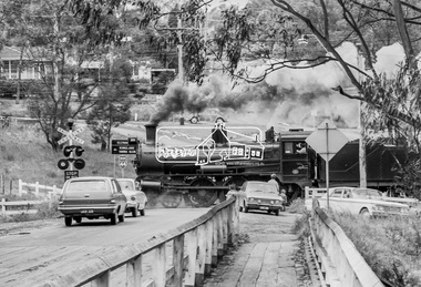 Eltham District Historical Society Inc
Photograph, Steam locomotive D639 with Tait (Red Rattler) carriages passing through the level crossing at Wattletree Road, Eltham bound for Hurstbridge, c.1970, 1970
Note the blue stone edging surrounding the grassy island in the intersection. This stone was originally part of the blue stone lock-up situated behind the Police Station and residence at 728 Main Road (present day Local History Centre and home to Eltham District Historical Society). Following a redesign of the intersection the stone was again relocated back to 728-730 Main Road for use as garden edging.Digital TIFF file Scan of 35mm Ilford HP4 black and white transparency728 main road, d-639, eltham, level crossing, local history centre, lockup, main road, police station, railway parade, red rattler, steam engine, wattletree road, wattletree road bridge -
 Ringwood and District Historical Society
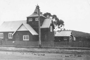
Photograph, Church of England, Ringwood - C/r Main St. & Pratt St - before moving (undated)
Inscription on back of small photograph reads, "Church of England, Ringwood - C/r Main St. & Pratt St. On Whitehorse Rd. before moving to Ringwood St." -
 Eltham District Historical Society Inc
Photograph, Liz Pidgeon, Heritage Excursion; Eltham Lower Park Walk and Talk, 1 July 2017, 1 July 2017
Sign: Nillumbik Shire Council Pony Club area dogs must be leashed horses must not be ridden on asphalt pathways Newsletter No., 234, June 2017 Heritage Excursion - Saturday 1st July - Eltham Lower Park - Walk and Talk Eltham Lower Park has played an important part in the history of our area since the early days of European settlement when it was used by local residents as an informal racecourse. Prior to that its location at the junction of the Diamond Creek and the Yarra River made it an important meeting place for the Wurundjeri people. The park combines formal elements and sporting facilities with remnant bushland that is of environmental significance. It is home to sporting and horse riding clubs, popular play spaces and the Diamond Valley Miniature Railway, which attracts large numbers of visitors. The park will be the venue for our July excursion which will comprise a walk of about 3.5 km around the park and adjacent areas. Along the way we will discuss the history and natural history of the area. The path along the creek and the river provides a pleasant and scenic walk. This walk on Saturday 1st July is about 3.5 km in length and will take 2 to 2.5 hours. It will start at 2pm at the Main Road car park at the front of the park. (Melway ref 21 H 10). Born Digitalelection day, heritage excursion, activities, eltham district historical society, eltham lower park, sign, eltham pony club