Showing 7474 items
matching the road to lower plenty
-
 Greensborough Historical Society
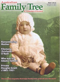
Journal, Australian Family Tree Connections, Australian Family Tree Connections August 2002
... Greensborough Historical Society 34A Glenauburn Road Lower ...Monthly, holdings include 23 issues August 2002 -May 2015Printed in colour and black & white, photographs family history -
 Greensborough Historical Society
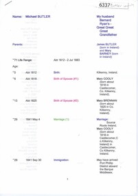
Genealogical Document, Michael Butler and family, 2017_
... Greensborough Historical Society 34A Glenauburn Road Lower ...Michael Butler and his family are recorded as living on the Plenty River in 1840. Later records and Titles give the address as Clear Hills near Greensborough. The location appears to be in Plenty.17 pages, including family tree and copies of titlesbutler family, michael butler, clear hills, plenty -
 Greensborough Historical Society
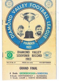
Magazine, Diamond Valley Football League, Diamond Valley Football League; Souvenir Record 1983, 17/09/1983
... Greensborough Historical Society 34A Glenauburn Road Lower ...Diamond Valley Football League; Souvenir Record 1983 Grand Final. A Grade teams Greensborough v BundooraPhotocopy of Football Recordgreensborough football club, diamond valley football league, bundoora football club -
 Greensborough Historical Society
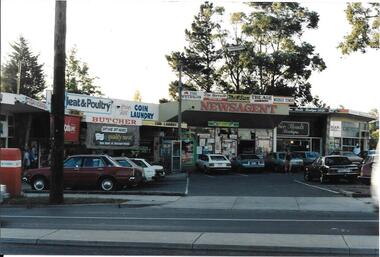
Photograph, Ian Bennetts, Briar Hill Shops 1990.1, 1990_
... Greensborough Historical Society 34A Glenauburn Road Lower ...Briar Hill shops, corner Mountainview Road and Sherbourne Road.Photographs taken in 1990, many businesses have changed but the buildings remain in 2019.Colour photograph"Briar Hill shops 1990" (photo taken by Ian Bennetts)briar hill, mountainview road briar hill, sherbourne road briar hill -
 Greensborough Historical Society
Photograph, Ian Bennetts, Briar Hill Shops 1990.2, 1990_
... Greensborough Historical Society 34A Glenauburn Road Lower ...Briar Hill shops, corner Mountainview Road and Sherbourne Road.Photographs taken in 1990, many businesses have changed but the buildings remain in 2019.Colour photograph"Briar Hill shops 1990 (photo taken by Ian Bennetts)"briar hill, mountainview road briar hill, sherbourne road briar hill -
 Greensborough Historical Society
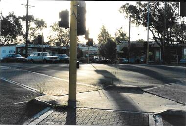
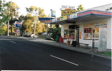
Photograph, Ian Bennetts, Looker Road Montmorency Shops 1990, 1990_
... Plenty Lower Plenty melbourne Photograph Looker Road Montmorency ...Looker Road shops,Looker Road Montmorency.Photographs taken in 1990, many businesses have changed but the buildings remain in 2019.Colour photograph"Looker Rd shop 1990 Monty. (photo taken by Ian Bennetts)"montmorency, looker road montmorency -
 Greensborough Historical Society
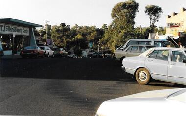
Photograph, Ian Bennetts, Were Street Montmorency Shops 1990.1, 1990_
... Greensborough Historical Society 34A Glenauburn Road Lower ...Shops corner Were Street and Rattray Road Montmorency. 1990Photographs taken in 1990, many businesses have changed but the buildings remain in 2019.Colour photograph"Montmorency 1990. Cnr Were St + Rattray Rd (photo taken by Ian Bennetts)"montmorency, were street montmorency, rattray road montmorency -
 Greensborough Historical Society
Photograph, Ian Bennetts, Were Street Montmorency Shops 1990.2, 1990_
... Greensborough Historical Society 34A Glenauburn Road Lower ...Shops in Were Street Montmorency. 1990Photographs taken in 1990, many businesses have changed but the buildings remain in 2019.Colour photograph"Montmorency. .Were St. 1990 (photo taken by Ian Bennetts)"montmorency, were street montmorency -
 Greensborough Historical Society
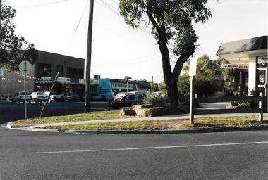
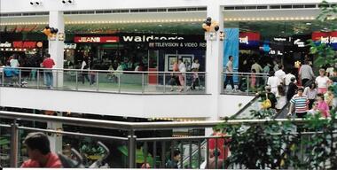
Photograph, Ian Bennetts, Greensborough Plaza 1990.1, 1990_
... Greensborough Historical Society 34A Glenauburn Road Lower ...Greensborough Plaza. 1990Photographs taken in 1990, many businesses have changed and there have been extensions and renovations to the shopping centre.Colour photograph"Greensborough Plaza 1990 (photo taken by Ian Bennetts)" -
 Greensborough Historical Society
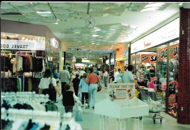
Photograph, Ian Bennetts, Greensborough Plaza 1990.2, 1990_
... Greensborough Historical Society 34A Glenauburn Road Lower ...Greensborough Plaza. 1990Photographs taken in 1990, many businesses have changed and there have been extensions and renovations to the shopping centre.Colour photograph"Greensborough Plaza 1990 (photo taken by Ian Bennetts)" -
 Greensborough Historical Society
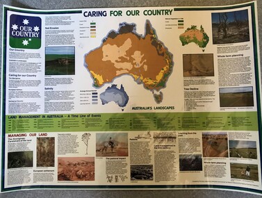
Poster, National Farmer's Federation et al, Caring for our Country, 1988c
... Greensborough Historical Society 34A Glenauburn Road Lower ...A timeline of land management including indigenous care and the impact of European settlement from 1988 to 1987. Includes maps showing present land use and vegetation coverage in 1788. Prepared by Tim Gurry for the National Farmer’s FederationLaminated poster, printed in colour on one side.land management, farming, salinity -
![Poster, The Age et al, Time Chart of Australian History [to 1980], 1980c](/media/collectors/4f729f5697f83e03086015b8/items/5cbeb83e21ea680ef0fa5549/item-media/5cbeb8f821ea680ef0fb5238/item-fit-380x285.jpg) Greensborough Historical Society
Greensborough Historical SocietyPoster, The Age et al, Time Chart of Australian History [to 1980], 1980c
... Greensborough Historical Society 34A Glenauburn Road Lower ...A timeline of Australian history from the first Australians, European exploration and discovery to 1980. Prepared by Ila Brown for The Age. Includes timeline, maps and photographsSet of 4 laminated posters, printed in colour on one side.australia history, australia exploration -
 Greensborough Historical Society
Map, Australia. Department of Minerals and Energy, Melbourne, topographic map, 1970_
... Greensborough Historical Society 34A Glenauburn Road Lower ...A topographic map of Victoria with Melbourne as the centre. Provisional edition showing contours in feet. International map of the world [scale] 1:1,000,000. Prepared by the Department of Minerals and Energy, Canberra in 1970.A pre-metric map, shows the Hume Highway travelling through towns such as Seymour and Benalla, now by-passed by the Hume Freeway.Map, printed in colour on one side.victoria - maps -
 Greensborough Historical Society
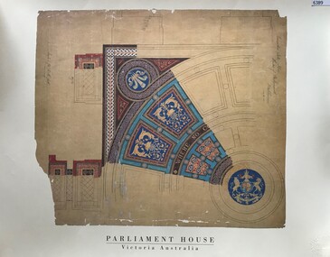
Poster, Parliament House Victoria, Parliament House Victoria: Vestibule: Encaustic tile floor, 1879_
... Greensborough Historical Society 34A Glenauburn Road Lower ...A facsimile of an original floor tile design for Parliament House Melbourne. An illustration by Peter Kerr, architect, of the vestibule pattern using encaustic tiling imported from England in 1879.Facsimile poster, printed in colour on one side.parliament house melbourne -
 Greensborough Historical Society
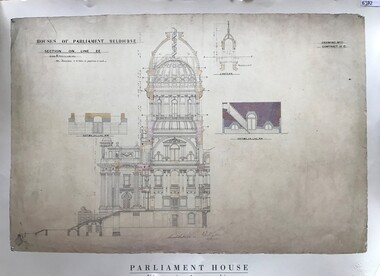
Poster, Parliament House Victoria, Parliament House Victoria: Main entrance. Portico, vestibule and dome, 1879_
... Greensborough Historical Society 34A Glenauburn Road Lower ...A facsimile of the original main entrance, portico, vestibule and dome for Parliament House Melbourne. An illustration by Peter Kerr, architect, 1879. The dome above the vestibule was never built.Facsimile poster, printed in colour on one side.parliament house melbourne -
 Greensborough Historical Society
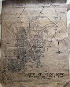
Map, City of Heidelberg, - excluding the North Ward, 1959, 27/05/1959
... Greensborough Historical Society 34A Glenauburn Road Lower ...Map of City of Heidelberg showing municipal and ward boundaries; North Ward is excluded from this map.Blue print map"Scale 20 chns to an inch. G.M.H. 27.5.59"city of heidelberg, heidelberg - maps -
 Greensborough Historical Society
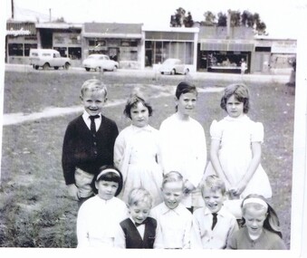
Photograph, Keith Willimott, Children at Church of Holy Spirit Watsonia c1968, 1968c
... Greensborough Historical Society 34A Glenauburn Road Lower ...Holy Spirit Church of England Sunday School Watsonia c1968 Back row: Ian Hatfield, Front row: Julie Mullinger? Mark Miller, Mark Ballard, Ken Willimott & Ann Hogan. Behind the children are the Watsonia Road shops, corner Watsonia Road and Morwell Avenue.Black and white photograph"Holy Spirit C of E Sunday School Watsonia 1968? Back row Ian Hatfield Front row Julie Mullinger? Mark Miller, Mark Ballard, Ken Willimott & Ann Hogan"holy spirit church of england watsonia, willimott family, morwell avenue watsonia, watsonia road watsonia -
 Greensborough Historical Society
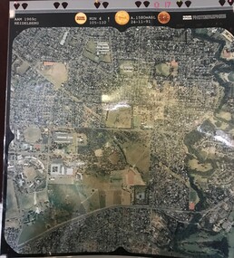
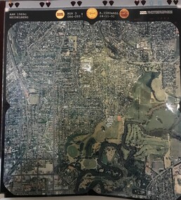
Aerial Photograph, AAM Photographics, Heidelberg AAM1969c 086, 24/11/1991
... Greensborough Historical Society 34A Glenauburn Road Lower ...One of a series of four overlapping aerial photographs of the Heidelberg/Greensborough areas in 1991, covering Simpson Barracks, Macleod, Rosanna, Viewbank, Watsonia & Yallambie. North boundary Yallambie Road; West boundary Hurstbridge railway.Laminated colour aerial photographssimpson barracks, yallambie, watsonia, macleod, rosanna, viewbank -
 Greensborough Historical Society
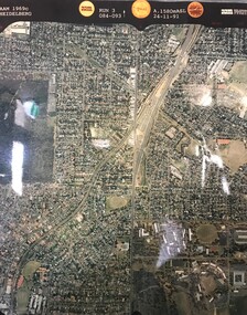
Aerial Photograph, AAM Photographics, Heidelberg AAM1969c 106, 24/11/1991
... Plenty River, South boundary Lower Plenty Road.... Plenty River, South boundary Lower Plenty Road. simpson barracks ...One of an overlapping series of aerial photographs of the Heidelberg/Greensborough areas in 1991, covering the Simpson Barracks, Greensborough & Viewbank. North boundary Nell Street, East boundary Plenty River, South boundary Lower Plenty Road.Laminated colour aerial photographsimpson barracks, greensborough, viewbank -
 Greensborough Historical Society
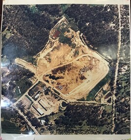
Aerial Photograph, AAM Photographics, Heidelberg AAM1969c 084, 24/11/1991
... Greensborough Historical Society 34A Glenauburn Road Lower ...One of an overlapping series of aerial photographs of the Heidelberg/Greensborough areas, covering Greensborough, Macleod, Viewbank & Yallambie. North boundary Nell Street, South boundary Simpson BarracksLaminated colour aerial photographgreensborough, viewbank, yallambie -
 Greensborough Historical Society
Aerial Photograph, AAM Photographics, Heidelberg AAM1969c 088, 24/11/1991
... Greensborough Historical Society 34A Glenauburn Road Lower ...One of a series of overlapping aerial photographs of the Heidelberg/Greensborough area, covering Eaglemont, Heidelberg, Ivanhoe East & Viewbank. North boundary Hurstbridge railway, South boundary Ivanhoe East, East boundary Bulleen RoadLaminated colour aerial photographeaglemont, heidelberg, ivanhoe east, viewbank -
 Greensborough Historical Society
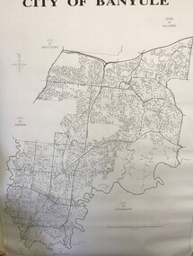
Maps, Banyule City Council, City of Banyule, 1970c
... Greensborough Historical Society 34A Glenauburn Road Lower ...Street map of City of Banyule. No physical features.Black and white map of City of Banyule. Scale: 8 cm:1 km. banyule city council -
 Greensborough Historical Society
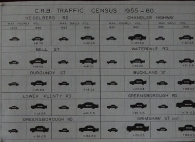
Diagram, C. R. B. Traffic Census 1955-1960, 07/06/1960
... Greensborough Historical Society 34A Glenauburn Road Lower ...The Country Roads Board, which had responsibility for major metropolitan roads, conducted a census of maximum hourly and daily traffic volumes recorded in 1955 and 1960 on 10 major roads in the Heidelberg and Greensborough areas.Black and white table G.M.H.traffic, heidelberg, greensborough, country roads board -
 Greensborough Historical Society
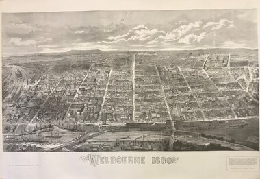
Engraving, Melbourne 1880, 1880_10
... Greensborough Historical Society 34A Glenauburn Road Lower ...This engraving of Melbourne CBD was originally issued as a supplement to the "Illustrated Australian News" in October 1880 to coincide with the opening of the Melbourne International Exhibition. The National Library of Australia, which holds the original, published a reproduction c. 1980.Black & white reproduction of original engraving held by the National Library of Australia.melbourne -
 Greensborough Historical Society
Map, Municipality of Heidelberg Plan No. 480, 17/10/1948
... Greensborough Historical Society 34A Glenauburn Road Lower ...Map shows streets, buildings, river and major drainage easements in area covered by West boundary Sellars Street, North boundary Yando Street & South boundary Grimshaw Street. Adjoins Map No. 481 to East. Black & white map, features marked in green, gradients in red. Scale: 160 feet to 1 inchgreensborough -
 Greensborough Historical Society
Map, Municipality of Heidelberg Plan No. 481, 23/9/1949
... Greensborough Historical Society 34A Glenauburn Road Lower ...Central area of Greensborough, South boundary Grimshaw Street, showing river and buildings in green and gradients in red. Adjoins Map No. 480 to West.Black & white map with features in red and green. Scale: 160 feet to 1 inch.greensborough, grimshaw street greensborough -
 Greensborough Historical Society
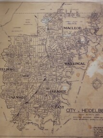
Map, City of Heidelberg: Municipal and Ward boundaries, 1967c
... Greensborough Historical Society 34A Glenauburn Road Lower ...This map of the City of Heidelberg was issued subsequent to the separation of Heidelberg's North Ward to become the Shire of Diamond ValleyBlack on waxed paper. Scale: 20 chs to 1 inchG M Hutchins. 50c.city of heidelberg, heidelberg -
 Greensborough Historical Society
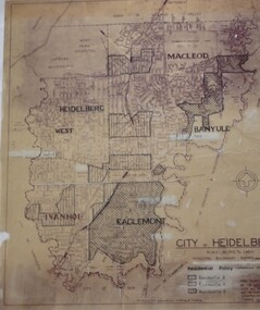
Map, City of Heidelberg: Residential Policy, 1976c
... Greensborough Historical Society 34A Glenauburn Road Lower ...Shows residential zones 3, 4 & 5 established by Residential Policy adopted 13/12/1976Black print on waxed paper. Scale: 20 chs to 1 inchG M Hutchins. $1city of heidelberg, heidelberg -
 Greensborough Historical Society
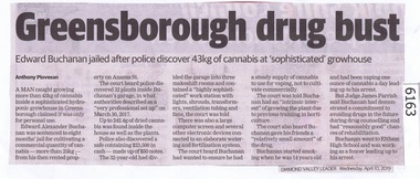
Newspaper Clipping, Diamond Valley Leader, Greensborough drug bust, 10/04/2019
... Greensborough Historical Society 34A Glenauburn Road Lower ...A man caught growing more than 43kg of cannabis inside a sophisticated hydroponic growhouse in Greensborough claimed it was only for personal use.News article 1 page, black text.greensborough, canabis, anama street greensborough, drugs -
 Greensborough Historical Society
Newspaper Clipping, Diamond Valley Leader, Tuning in to help addicts, 10/04/2019
... Greensborough Historical Society 34A Glenauburn Road Lower ...People battling gambling problems have a new resource to turn to with a podcast being launched by Banyule Community Health, run by former addict Shayne RodgersNews article 1 page, black text.banyule community health, shayne rodgers, gambling addiction