Showing 11111 items
matching planning
-
 Federation University Historical Collection
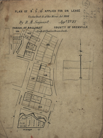
Plan, Lease Applied for by R.M. Serjeant, c1890, c1890
Plan of a lease showing streets around Skipton and Windermere Streets, Redan. Scale 4 chains to 1 inch (!:3168)serjeant, r.m.serjeant, robert m. serjeant, george street, skiptn street, windermere stret, rubicon stret, cobdon street, ascot street, lease, redan, ballarat, robert malachi serjeant, band of hope and albion mine -
 Federation University Historical Collection
Plan, Plan of Mount Helen, 7/7/1964
Plan of Subdivisions to Mount Helen, Shire of Buninyong, Sheet 1 and Sheet 2 Scale 200 feet to one inchmidland highway, gear avenue, eddy avenue, shire avenue, boak avenue, moss avenue, rathkeale avenue, ingliston avenue, chatham avenue, mardango drive, nyora grove, yarana drive, shakespeare avenue, marina avenue, landale avenue, lylia avenue, recreation road, olympic avenue, the gums, heather avenue, dallas avenue, jones avenue, sebastopol mount clear road -
Federation University Historical Collection
Poster, University of Ballarat Camp Street Campus, 2000, 2000
The University of Ballarat became Federation University Australia in 2014. The Camp Street Campus was later known as the Arts Academy. Framed poster of a collage of images showing plans for the University of Ballarat Camp Street Campus, later known as the Arts Academy. "In acknowledgement of the joint agreement to redevelop historic camp Street as a dynamic arts precinct utilising the central business district area of Ballarat."arts academy, camp street precinct, camp street, arts precinct -
 Federation University Historical Collection
Plan, Ballarat School of Mines E.J. Tippett Learning Resource Centre Signs, 19/05/1986
Plans for signage of the Ballarat Sxhool of Mine Library - The E.J. Tippett Learning Resource Centre. Includes front elevation of building. plan, tippett library, e.j. tippett library, e.j. tippett learning resource centre, gadsden signs, ballarat schoo of mines -
 Ringwood and District Historical Society
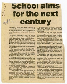
Newspaper - Clipping, Norwood High School, Ringwood, Victoria - "School aims for the next century"
Newspaper report June1987 outlining 21st century planning workshop topics addressed by council president Mr Max Williams. -
 Bendigo Historical Society Inc.
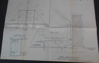
Plan - GOLDEN SQUARE HIGH SCHOOL COLLECTION: PLAN BASKETBALL AND TENNIS COURTS
Golden Square High School proposed basketball and tennis courts site extracted from P.W.D. plan 65-474education, secondary, golden square -
Bendigo Historical Society Inc.
Document - NEW CHUM LINE OF REEF - REFERENCE FOR CALEB THOMAS PLANS
Two handwritten pages of reference numbers for Caleb Thomas plans. The numbers refer to mines on the New Chum Line of Reef.document, gold, new chum line of reef, new chum line of reef, reference for caleb thomas plans, new chum bellevue & railway reserve, bellevue & new chum, shenandoah, shamrock, old chum, little chum, new chum trib, young chum, cravens, garibaldi, no 1 ellesmere coy, new chum consolidated, ellesmere, new chum united, lansell's 222 (denis), lansell's 222 (new shaft), koch & hildebrandt (lansell's 222), lazarus co, sheer legs, old chum, new chum & victoria, north old chum, lansell's 180, victoria quartz, gt cent vic, victoria consols, victoria reef co (ironbark), hercules, energetic ladder shaft, energetic shaft -
 Bendigo Historical Society Inc.
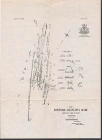
Map - STRUGNELL COLLECTION: HUSTLER'S LINE OF REEFS, BENDIGO, September 1913
Map, Hustler's Line of Reefs, Fortuna Hustler's Mine, Plan, Plate No.11(2).Bulletin No 33 Signed H.A.Whitelaw.Underground Survey Office, Bendigo.map, bendigo, fortuna hustler's mine -
 Bendigo Historical Society Inc.
Document - FORTUNA COLLECTION: BENDIGO FORTUNA VILLA AUCTION
Plan of Fortuna Villa and grounds loose page intended as part of 12th april 2013 Auction Document Cat No 6763.1bendigo, buildings, fortuna villa, bendigo fortuna villa -
Port Melbourne Historical & Preservation Society
Map - Albert Park, South Melbourne and part of Port Melbourne, MMBW
Melbourne and Metropolitan Board of Works Plan 9E-NE depicting Albert Park, S. Melbourne and (part of) Port Melbourne.mmbw, melbourne and metropolitan board of works -
Port Melbourne Historical & Preservation Society
Plan - Outer berth Passenger Terminal fit-out, Station Pier, PMA, P B Keighran, Port of Melbourne Authority, 1987
Port of Melbourne Authority revised floor and section plans for Station Pier Outer Berth passenger Terminal Fit-out.piers and wharves - station pier -
Port Melbourne Historical & Preservation Society
Plan - Upper Bay Street, annotated by Marilyn Allport showing names of various residents, mid 20th C, Marilyn Allport
Marilyn Allport annotated plan of upper Bay St area showing names of various residents in mid 20th centurynotations are in pencilbuilt environment - domestic, built environment - commercial, industry, families, war - world war ii, marilyn allport, max allport, janet bolitho -
Port Melbourne Historical & Preservation Society
Plan - Toll bar, house and closet, Sandridge, Charles Clay?, Borough Surveyor, 1860s - 1870s
Plan and elevation for Borough of Sandridge toll bar, house and closet, hand drawn and coloured 1860s-70s. Master copy.Signed by Chas. Clay, Suveyor and John L. Forrester (?) and witnessed bt Thomas R. Warren (?).built environment - civic, charles clay, thomas peek warren, john l forrester -
Port Melbourne Historical & Preservation Society
Plan, 1870s
Unidentified, undated plans believed to be for the Market shed, market site (ref Turnbull/U'ren pp 102-9, 132)engineering department - borough of sandridge, market reserve -
Port Melbourne Historical & Preservation Society
Plan - Williamstown Road from Salmon Street to Prohasky Street, Engineering Department, Town of Port Melbourne, 1893 - 1919
Plan of Williamstown Road (Reconstruction of pitched portion). From Salmon Street to Prohasky Street. 1893 Loan Number 5.Reverse side - Williamstown Road, west of Salmon (Pitcher Construction).engineering - roads streets lanes and footpaths -
Port Melbourne Historical & Preservation Society
Map - Melbourne and suburbs, MMBW, 8 Dec 1909
MMBW map of Melbourne and suburbs - Record plan up to July 1st 1913 (scale 3/4" = 1 mile)engineering - board of works, calder e oliver, russwaul(?) -
NMIT (Northern Melbourne Institute of TAFE)
Report: Visual and Performing Arts Centre: concept proposal NMCOT 1990
A4 size bound report with clear plastic cover. Text covers 26 pages plus plans, tables, images.northern metropolitan college of tafe, reports, nmit -
Bendigo Historical Society Inc.
Document - VICTORIA HILL - VICTORIA HILL AND NEW CHUM HILL
Typed notes on Victoria Hill and New Chum Hill. Notes give location, value of gold and plans for a mining museum.document, gold, victoria hill, victoria hill, victoria hill and new chum hill, john neil macartney, the age, the australasian, bendigo goldfields registry 1871, victoria reef quartz mine, north old chum, victoria consols, new chum and victoria, pioneer, lansell 222 mine, lazarus, barnet lazarus, mt. alvernia hospital, fortuna villa, george lansell, a. h. q. survey regiment, central red white and blue, hudsons, burrowes & sterry, b c v channel 8, bendigo and district tourist association, section 14 of the lands act 1958, mr a r richardson, cr t r flood, tourist association -
 Bendigo Historical Society Inc.
Document - MCCOLL, RANKIN AND STANISTREET COLLECTION: NORTH MONUMENT
Documents: Manilla folder - Plan of area applied for on lease No. 10023 Ben. Prospectus of the Monument Hill Gold Mining Company.MCCOLL RANKIN & STANISTREETorganization, business, gold mining lease, mccoll rankin & stanistreet -
 Bendigo Historical Society Inc.
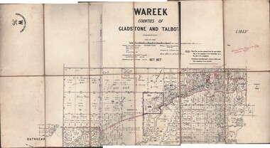
Map - JACK FLYNN COLLECTION: WAREEK, Examined 1918
Map: L.1053. Parish of Wareek, Counties of Gladstone and Talbot. Parish plan. Looks like half of the sheet is missing.Second Issue. Examined by S.F. Green. July 1918. William J. Swan, Draughtsman, August 1884. Photo-Lithographic Fac-Simile, W 36.map, gladstone, parish plan, wareek -
NMIT (Northern Melbourne Institute of TAFE)
Report: Strategy plan 1991 Northern Metropolitan College of TAFE
A4 size bound booklet of 72 pages. Years 1991-1993. Also 59 page Management plan 1991.reports, northern metroplitan college of tafe, nmit -
Bendigo Historical Society Inc.
Map - PART PARISHES OF SANDHURST MARONG AND NERRING, No date visible
Map: Section of a Parish plan of Bendigo, covering Ironbark, Eaglehawk and Myers Flat ( number 145 in Map Cupboard 1)map, bendigo, city streets, parish of sandhurst, parish of marong, parish of nerring, ironbark, eaglehawk, myers flat -
Bendigo Historical Society Inc.
Map - BENDIGO IRRIGATION SETTLEMENT, 12/02/1908
Map: Plan of Bendigo Irrigation Settlement, Parishes of Sandhurst and Wellsford, County of Bendigo ( number 160 in Map Cupboard 1)map, bendigo, irrigation settlement, bendigo irrigation settlement, parishes of sandhurst and wellsford, county of bendigo -
Bendigo Historical Society Inc.
Map - TOWNSHIP OF KANGAROO FLAT, 27/01/1932
Map: Township of Kangaroo flat, Parish of Sandhurst , County of Bendigo. Parish plan ( number 194 in Map Cupboard 1)map, bendigo, township, kangaroo flat -
Bendigo Historical Society Inc.
Map - BOROUGH OF EAGLEHAWK, 30/11/1931
Map: Borough of Eagle hawk, Parish of Nerring. Parish plan with coloured areas ( number 185 in Map Cupboard 1)map, bendigo, parish plan, borough of eaglehawk, parish of nerring -
Bendigo Historical Society Inc.
Map - TARNAGULLA (PARTS), Circa 1880's
Map: Compilation of 3 hand draughted parish plans showing portions of Tarnagulla (number 261 in map cupboard 1)map, parish plan, tarnagulla -
Bendigo Historical Society Inc.
Map - TOWNSHIP OF HEATHCOTE (PART), 11/04/1935
Map: Township of Heathcote (part), Parish of Heathcote, County of Dalhousie. Parish plan (number 259 in map cupboard 1)map, dalhousie, township, heathcote, copunty of dalhousie -
Bendigo Historical Society Inc.
Map - HUNTLY (PART) RESURVEY, Circa 1877
Map: Huntly [part) resurvey, Parish of Huntly, County of Bendigo. Parish plan ( number 243 in Map Cupboard 1)map, bendigo, parish plan, huntly -
Bendigo Historical Society Inc.
Map - PARISH OF EPPALOCK RESURVEY, 23/05/1876
Map: Parish of Eppalock resurvey, County of Bendigo, hand draughted Parish plan ( number 240 in Map Cupboard 1)map, bendigo, parish plan, eppalock, resurvey -
Bendigo Historical Society Inc.
Map - SANDHURST (PART), Circa 1880's
Map: Parish plan showing the area Specimen Hill Road and Inglewood St. ( number 222 in Map Cupboard 1)map, bendigo, parish plan, specimen hill rd. inglewood st.